Stateline Lookout Trail Photos


You might also consider
More like Stateline Lookout Trail
Recommended Reviews - Stateline Lookout Trail
Start your review...

Reviews With Photos


Wow! The views from the lookout are amazing. This is a must see while in the area. *Double check directions beforehand. Some Yelpers have added detailed information on how to get there and where to park. The walk up the paved road is short and relatively painless due to it being on a paved road. My friend and I spent time at the lookout taking in all of the beauty that the lake and surrounding area offer. It was very peaceful up there.

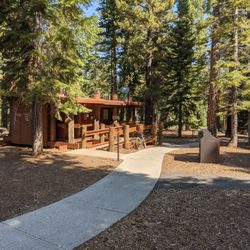
The last time we hiked Stateline Fire Lookout, the trail was deeply covered with snow so it was a little challenging but we enjoyed it. We hiked it again a couple days ago on a gorgeous day and it was spectacular! It is not a long hike (less than 2 miles roundtrip) but the steep climb on the way up makes it feel like a nice little workout. And we were rewarded with gorgeous landscape views of our beautiful Lake Tahoe. If you hike it, make sure you include the little loop at the top along with heading to the lookout in the middle (where there are bathrooms, if needed). Check out AllTrails for specifics. There is plenty of parking along the street at the trailhead.
")

I always look for pictures of the parking area, I couldn't find any so I'm posting them here. Hope this helps others who choose to do this hike and need visual advice. Go past Tahoe Biltmore Lodge & Casino, go slow so you don't miss Reservoir Road (I almost missed it) where you will turn left. Then turn right when you see the "Fire Lookout" sign in front of what appeared to be a fire station (I can't remember). Drive all the way up until you reach a steady incline, once you begin seeing cars parked along the right side of the road, park like them. Then walk up to the closed off uphill gate to begin the trail. FYI in March, you can easily walk the trail without your normal shoes.

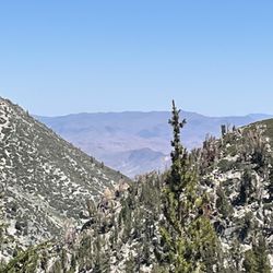
WHEN: May 29 @ 1:30pm Not a busy day for hiking at all. There was a lot of parking at the side of the road. This is one of the easiest hikes out of multiple trails at Lake Tahoe. It was straight incline for about a mile or so to get to the lookout area. It was a very simple hike that requires endurance and cardio. The lookout is marvelous, overlooking the Nevada and California sides of Lake Tahoe. Great spot for photo taking. If you go during the late spring, I suggest hiking before the sun is blaring, which is before noon.

Stateline Fire Lookout is a secluded "hidden gem" that not many folks here in Lake Tahoe visit. It's situated near the Biltmore Lodge and it's a straightforward hike, overall, with pretty views of the North Lake Tahoe region. Backing up just a little.....this trail and scenic overlook is difficult to find, at least it was for me. Good thing, though...if you plug "Stateline Lookout Trail" into Google Maps like I did, it'll very much help you find this trailhead. One thing....when you do arrive here, basically you're looking for a GREEN GUARD GATE. Although it appears as though there's no accessible hiking area, just park on the side of the road, get out of your car, and start walking behind the green gate and you're on your way!. Lol....I tell ya, I got so confused about finding this place at first, because the green guardrail gate seemed like a very "no access" zone. But this is the true beginning of the trail. I had researched that upon arriving at the pinnacle of this hike, you can circumnavigate around the top, crossing into and out of the Nevada/California border and capturing all sorts of angles of this picturesque setting.....yet when I thought I found this path, it quickly ended. There was no further exploration or self guiding footpath. Ultimately I was simply left with appreciating the scenic views and wonderful landscape of Lake Tahoe below. (It is possible my info and research about this trail could have been outdated that they eliminated the walkway at the peak). Regardless....the backdrop, epic terrain and pristine waters of Lake Tahoe below made this hike worthwhile. Although I mentioned the climb to the top is straightforward, it is sort of strenuous as you ascend uphill the entire way for roughly 3/4's of a mile. But, you can certainly take your time and there's no rush to the top. Upon arriving to the summit, you can sneak through an alleyway that grants clear access and visibility to almost all of the Tahoe region. Photos here were fantastic, and I even safely climbed on some rocks lending to the perfect setting! As you approach the peak, this little footpath is off to the left. It can't be missed. Also, up at the mountaintop is a guarded circular overlook gazing down onto Kings Beach. Unfortunately I found this section to be a little tight quartered and the ledge and hand rails sort of obstructed some of my photographing. You can stand on top of the brick wall ledge, but it distorts your size with the distance of the background beyond you (if you understand what I mean, lol). Overall though, Stateline Fire Lookout is a casual, relatively undiscovered part of Lake Tahoe. It's good for capturing glimpses of the surrounding water, beach coastline and panoramic terrain around you. Especially, when I visited back in June in the height of travel season, all of Lake Tahoe was highly crowded and yet this trail made for a pleasant off the beaten path escape.

If you want a quick, all skill levels hike with a killer view- this is the one. The first two-thirds is a steep grade fire access road that is paved and wide. Near the top is a narrow side trail (also paved) on the left that has several benches and historical facts along the way. This path will take you on a full loop around the actual lookout point with spectacular views of both the Nevada and California sides of the lake, as well as Crystal Bay and King's Beach. There are bathrooms (when season permits) and picnic tables near the top. Of course the best view is at the very top, where the original lookout tower used to be. Do yourself a favor and make this one.

This ended up being one of our two "family hikes" while staying in Lake Tahoe. Our kids, ages 5, 3, and 1 (walking - almost 2), were able to make it up and down the hill on their own due to the ease, width and grade of this cool little trail! There's some parking along the paved road at the corner of Lakeview Avenue and Lookout Road, right in front of the gate which serves as the trailhead. We hopped out and made the hike to the lookout at the top in about 35 minutes, and that was with stopping a few times for pictures along the way. The lookout at the top has benches and a perch overlooking Kings Beach, Crystal Bay, Agate Bay, and the lake at large. There are even permanent restrooms! I highly recommend this to the families out there - it's a great taste of the natural side of Tahoe and is do-able even for really little ones! ....and, mild enough for the moms and dads who end up having to carry the little ones if/when they do get a little fussy or tired :)

Found this lookout on Trip Advisor as we were looking for a nice lookout point during our visit to Lake Tahoe. The lookout is up the road from the Biltmore hotel. Park at the green gate and walk up the paved road to the lookout. There is a restroom and a few lookout points as well as a well-defined hiking trail leading down from the lookout. The paved road up from the gated entrance is about a half mile or so. I'd say it took us about 15 minutes to reach the lookout. We were all wearing slippers, so it's quite easy.

I'm shocked we didn't see more people on this hike! We did the popular Monkey rock and eastshore bike trails but thought stateline fire had the best views. I don't think this trail is difficult to find. We put in Stateline fire lookout trail on our Waze app and it took us directly there. When you get close, just start looking for a green service gate on the right side that says do not enter. Do a u-turn and park across the street with the other cars. Your hike starts behind the green gate. Very straight forward hike but not the easiest because it's steep uphill for almost the entire way. You can veer off the main path and go to the left to read some history regarding the trail and take in the views or sit on one of the beaches to rest. Once at the top, you can see the entire Lake Tahoe with King's beach directly below. We soaked in the breathtaking backdrop for at least 30 minutes. Time it correctly and do a sunset hike here. The view is epic!

Just a short drive from The Tahoe Biltmore you'll find this little gem of a hike that offers up some of the most spectacular high elevation views of Lake Tahoe. The hike is a steady uphill climb up a paved fire road and is great for all ages. There is a restroom at the top and several Vista points for viewing the lake along a well maintained trail at the top. Be sure to pack a lunch because you'll want to linger and soak in the beauty of the Lake. You won't find any signs pointing the way as you drive up to the trailhead. Take Reservoir Road at 28 and the Tahoe Biltmore Lodge, then turn right at the firehouse. Continue up the hill until you see a U.S. Forest Service road with a locked gate across it. Do not park in front of or block the gate. Park on the shoulder of Lakeview Avenue across from the gate.

We parked on the side of the road and made our way up. The hike is 1.7 miles long. The path was straightforward, but there were some small patches of snow. At the end, you are rewarded with a view of the lake. read more


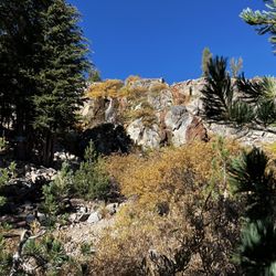
This was a quick hike to gain epic views of North Lake Tahoe. It is a 1.7 mile loop with an elevation gain of 340 feet near Crystal Bay. The location can be tricky to find, just don't pass Reservoir Road which is easy to do. It's really more of a fire road that is paved with a steep grade up to the top. The cool thing about this fun adventure is that the trail begins in Nevada and ends in California at the lookout. The views are absolutely phenomenal at the top and you will find it hard to leave. The actual fire lookout no longer exists. Along the loop you will find several benches and signs with information about the history of the North Shore of Lake Tahoe. The signage was added in 1996 and could stand to be updated. This is definitely a must stop when in this area of Lake Tahoe. *Parking is within a neighborhood so be careful where you park and most of all #LeaveNoTrace read more


11 months ago
Quick little hike, about a mile and a half from gate to top to back down again. It's a 300 foot elevation climb in only about 30-40 minutes so be prepared/ advised thats fairly steep for 6750 feet above sea level. When you do get up there it's beautiful- pretty much see the whole lake from there! read more

6 months ago
9 months ago
Great light hike. Parking is limited along the rode so I recommend going early. Hike is inclined the whole way but it's paved which made it easier. The views were amazing and I would go again. read more

2 years ago
Nice easy hike (about a mile) with amazing views of Lake Tahoe, Stateline area and Kings Beach. Several benches along the trail and in warmer weather, picnic tables. read more


Wow! The views from the lookout are amazing. This is a must see while in the area. *Double check directions beforehand. Some Yelpers have added detailed information on how to get there and where to park. The walk up the paved road is short and relatively painless due to it being on a paved road. My friend and I spent time at the lookout taking in all of the beauty that the lake and surrounding area offer. It was very peaceful up there. read more

3 years ago
The last time we hiked Stateline Fire Lookout, the trail was deeply covered with snow so it was a little challenging but we enjoyed it. We hiked it again a couple days ago on a gorgeous day and it was spectacular! It is not a long hike (less than 2 miles roundtrip) but the steep climb on the way up makes it feel like a nice little workout. And we were rewarded with gorgeous landscape views of our beautiful Lake Tahoe. If you hike it, make sure you include the little loop at the top along with heading to the lookout in the middle (where there are bathrooms, if needed). Check out AllTrails for specifics. There is plenty of parking along the street at the trailhead. read more


2 years ago
Reading the reviews on directions were helpful. Don't follow google maps. The path is paved to the top. There are dirt paths along the edge with historical plaques (well worn out). Great views! read more
 - Hiking Near Me - Kings Beach, California")


4 years ago
I always look for pictures of the parking area, I couldn't find any so I'm posting them here. Hope this helps others who choose to do this hike and need visual advice. Go past Tahoe Biltmore Lodge & Casino, go slow so you don't miss Reservoir Road (I almost missed it) where you will turn left. Then turn right when you see the "Fire Lookout" sign in front of what appeared to be a fire station (I can't remember). Drive all the way up until you reach a steady incline, once you begin seeing cars parked along the right side of the road, park like them. Then walk up to the closed off uphill gate to begin the trail. FYI in March, you can easily walk the trail without your normal shoes. read more


WHEN: May 29 @ 1:30pm Not a busy day for hiking at all. There was a lot of parking at the side of the road. This is one of the easiest hikes out of multiple trails at Lake Tahoe. It was straight incline for about a mile or so to get to the lookout area. It was a very simple hike that requires endurance and cardio. The lookout is marvelous, overlooking the Nevada and California sides of Lake Tahoe. Great spot for photo taking. If you go during the late spring, I suggest hiking before the sun is blaring, which is before noon. read more


Stateline Fire Lookout is a secluded "hidden gem" that not many folks here in Lake Tahoe visit. It's situated near the Biltmore Lodge and it's a straightforward hike, overall, with pretty views of the North Lake Tahoe region. Backing up just a little.....this trail and scenic overlook is difficult to find, at least it was for me. Good thing, though...if you plug "Stateline Lookout Trail" into Google Maps like I did, it'll very much help you find this trailhead. One thing....when you do arrive here, basically you're looking for a GREEN GUARD GATE. Although it appears as though there's no accessible hiking area, just park on the side of the road, get out of your car, and start walking behind the green gate and you're on your way!. Lol....I tell ya, I got so confused about finding this place at first, because the green guardrail gate seemed like a very "no access" zone. But this is the true beginning of the trail. I had researched that upon arriving at the pinnacle of this hike, you can circumnavigate around the top, crossing into and out of the Nevada/California border and capturing all sorts of angles of this picturesque setting.....yet when I thought I found this path, it quickly ended. There was no further exploration or self guiding footpath. Ultimately I was simply left with appreciating the scenic views and wonderful landscape of Lake Tahoe below. (It is possible my info and research about this trail could have been outdated that they eliminated the walkway at the peak). Regardless....the backdrop, epic terrain and pristine waters of Lake Tahoe below made this hike worthwhile. Although I mentioned the climb to the top is straightforward, it is sort of strenuous as you ascend uphill the entire way for roughly 3/4's of a mile. But, you can certainly take your time and there's no rush to the top. Upon arriving to the summit, you can sneak through an alleyway that grants clear access and visibility to almost all of the Tahoe region. Photos here were fantastic, and I even safely climbed on some rocks lending to the perfect setting! As you approach the peak, this little footpath is off to the left. It can't be missed. Also, up at the mountaintop is a guarded circular overlook gazing down onto Kings Beach. Unfortunately I found this section to be a little tight quartered and the ledge and hand rails sort of obstructed some of my photographing. You can stand on top of the brick wall ledge, but it distorts your size with the distance of the background beyond you (if you understand what I mean, lol). Overall though, Stateline Fire Lookout is a casual, relatively undiscovered part of Lake Tahoe. It's good for capturing glimpses of the surrounding water, beach coastline and panoramic terrain around you. Especially, when I visited back in June in the height of travel season, all of Lake Tahoe was highly crowded and yet this trail made for a pleasant off the beaten path escape. read more


8 years ago
If you want a quick, all skill levels hike with a killer view- this is the one. The first two-thirds is a steep grade fire access road that is paved and wide. Near the top is a narrow side trail (also paved) on the left that has several benches and historical facts along the way. This path will take you on a full loop around the actual lookout point with spectacular views of both the Nevada and California sides of the lake, as well as Crystal Bay and King's Beach. There are bathrooms (when season permits) and picnic tables near the top. Of course the best view is at the very top, where the original lookout tower used to be. Do yourself a favor and make this one. read more


This ended up being one of our two "family hikes" while staying in Lake Tahoe. Our kids, ages 5, 3, and 1 (walking - almost 2), were able to make it up and down the hill on their own due to the ease, width and grade of this cool little trail! There's some parking along the paved road at the corner of Lakeview Avenue and Lookout Road, right in front of the gate which serves as the trailhead. We hopped out and made the hike to the lookout at the top in about 35 minutes, and that was with stopping a few times for pictures along the way. The lookout at the top has benches and a perch overlooking Kings Beach, Crystal Bay, Agate Bay, and the lake at large. There are even permanent restrooms! I highly recommend this to the families out there - it's a great taste of the natural side of Tahoe and is do-able even for really little ones! ....and, mild enough for the moms and dads who end up having to carry the little ones if/when they do get a little fussy or tired :) read more


12 years ago
Found this lookout on Trip Advisor as we were looking for a nice lookout point during our visit to Lake Tahoe. The lookout is up the road from the Biltmore hotel. Park at the green gate and walk up the paved road to the lookout. There is a restroom and a few lookout points as well as a well-defined hiking trail leading down from the lookout. The paved road up from the gated entrance is about a half mile or so. I'd say it took us about 15 minutes to reach the lookout. We were all wearing slippers, so it's quite easy. read more


I'm shocked we didn't see more people on this hike! We did the popular Monkey rock and eastshore bike trails but thought stateline fire had the best views. I don't think this trail is difficult to find. We put in Stateline fire lookout trail on our Waze app and it took us directly there. When you get close, just start looking for a green service gate on the right side that says do not enter. Do a u-turn and park across the street with the other cars. Your hike starts behind the green gate. Very straight forward hike but not the easiest because it's steep uphill for almost the entire way. You can veer off the main path and go to the left to read some history regarding the trail and take in the views or sit on one of the beaches to rest. Once at the top, you can see the entire Lake Tahoe with King's beach directly below. We soaked in the breathtaking backdrop for at least 30 minutes. Time it correctly and do a sunset hike here. The view is epic! read more


4 years ago
Just a short drive from The Tahoe Biltmore you'll find this little gem of a hike that offers up some of the most spectacular high elevation views of Lake Tahoe. The hike is a steady uphill climb up a paved fire road and is great for all ages. There is a restroom at the top and several Vista points for viewing the lake along a well maintained trail at the top. Be sure to pack a lunch because you'll want to linger and soak in the beauty of the Lake. You won't find any signs pointing the way as you drive up to the trailhead. Take Reservoir Road at 28 and the Tahoe Biltmore Lodge, then turn right at the firehouse. Continue up the hill until you see a U.S. Forest Service road with a locked gate across it. Do not park in front of or block the gate. Park on the shoulder of Lakeview Avenue across from the gate. read more

 - Hiking Near Me - Kings Beach, California")


7 years ago
Awesome hike that leads to a beautiful scenery up top. Lots of places to sit once you make the somewhat steep hike up. (It was steep for us because we are wimpy Floridians who don't have mountains ) great hidden hike that wasn't very crowded read more


8 years ago
Short hike, but worth the view, especially if you make it to a sunset. It is not too high up the hill and very do-able for children even when it has snow. There are many families that take this hike up because it is easy, fast and provides one with a spectacular reward. In fact, my son and I have done this hike twice. I hope to share this one with all my friends when we visit Tahoe. read more


9 years ago
TAKE. THIS. TRAIL! This is one of the best "hikes" I've ever experienced. Somewhat tucked away it took my fiancé and I a few trips around the block to find. Parking along side of the road is plenty and the path is paved the entire ascent. A mile up a moderately steep climb, this gem will forever be a stop for the family. So rewarding at the top. Simple vault restrooms sit at the place of the old tower and there is an interactive loop trail (paved) and a rock lined vista point. Could not have been happier with our time up here! read more


8 years ago


7 years ago
9 years ago
10 years ago
11 years ago
10 years ago
More info about Stateline Lookout Trail
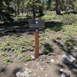
Forest Service Road 1601
Kings Beach, CA 96143
Directions
Hours
Outdoor Amenities
Ask the Community - Stateline Lookout Trail
Review Highlights - Stateline Lookout Trail
You might also consider


Why does Yelp recommend reviews?
2 reviews that are not currently recommended
The reviews below are not factored into the business's overall star rating.
6 years ago
9 years ago
Stateline Lookout Trail - hiking - Updated May 2026
Best of Kings Beach
People found Stateline Lookout Trail by searching for…
Things to Do in Kings Beach, CA
Beautiful Views in Kings Beach, CA
Hiking Trails in Kings Beach, CA
Places to Take Pictures in Kings Beach, CA
Scenic View in Kings Beach, CA
Watch Sunset in Kings Beach, CA
Walking Trails in Kings Beach, CA
Scenic Overlook in Kings Beach, CA
Scenic Drive in Kings Beach, CA
Fishing Spots in Kings Beach, CA
Photo Spots in Kings Beach, CA
Picnic Areas in Kings Beach, CA
Secluded Spots in Kings Beach, CA
Off Road Trails in Kings Beach, CA
Secret Spots in Kings Beach, CA
Lookout Points in Kings Beach, CA
Sunset View in Kings Beach, CA
View Points in Kings Beach, CA
Trending Searches in Kings Beach, CA
Boat Rental near Stateline Lookout Trail
Botanical Gardens near Stateline Lookout Trail
Bounce House Rentals near Stateline Lookout Trail
Campgrounds near Stateline Lookout Trail
Cherry Picking near Stateline Lookout Trail
Cliff Jumping near Stateline Lookout Trail
Dog Friendly Things To Do near Stateline Lookout Trail
Flower Fields near Stateline Lookout Trail
Flower Shop near Stateline Lookout Trail
Garage Sales near Stateline Lookout Trail
Hair near Stateline Lookout Trail
Lakes & Ponds near Stateline Lookout Trail
Nurseries & Gardening near Stateline Lookout Trail
Outdoor Activities near Stateline Lookout Trail
Outdoor Furniture Stores near Stateline Lookout Trail
Parks near Stateline Lookout Trail
Party Equipment Rentals near Stateline Lookout Trail
Pedicure near Stateline Lookout Trail
Pick Your Own Farms near Stateline Lookout Trail
Picnic Areas near Stateline Lookout Trail
Places To Take Pictures near Stateline Lookout Trail
Running Trails near Stateline Lookout Trail
Scenic Drive near Stateline Lookout Trail
Secret Spots near Stateline Lookout Trail
Strawberry Picking near Stateline Lookout Trail
Sunrise View near Stateline Lookout Trail
Swimming Holes near Stateline Lookout Trail
Table And Chair Rentals near Stateline Lookout Trail
Browse Articles
Browse Nearby
BEST of Kings Beach, California Coffee near Stateline Lookout Trail
BEST of Kings Beach, California Restaurants near Stateline Lookout Trail
BEST of Kings Beach, California Things to Do near Stateline Lookout Trail
BEST of Kings Beach, California Breakfast near Stateline Lookout Trail
BEST of Kings Beach, California Parks near Stateline Lookout Trail
BEST of Kings Beach, California Lakes near Stateline Lookout Trail
BEST of Kings Beach, California Hotels near Stateline Lookout Trail
BEST of Kings Beach, California Campgrounds near Stateline Lookout Trail
BEST of Kings Beach, California Sledding near Stateline Lookout Trail
Browse Brands
Related Searches in Kings Beach, CA
Affordable Kayak Rental Services in Kings Beach, California
Best Fishing Locations and Guides in Kings Beach, California
Best Places for Horseback Riding in Kings Beach, California
Best Sledding Spots and Fun in Kings Beach, California
Best Waterfalls and Swimming Holes in Kings Beach, California
Check Out Off Road Trails in Kings Beach, California
Discover Dog Friendly Trails to Explore in Kings Beach, California
Discover Kid Friendly Hiking Trails in Kings Beach, California
Discover Scenic Mountain Bike Trails Near Kings Beach, California
Discover Scenic Waterfall Spots in Kings Beach, California
Discover a Hiking Trail in Kings Beach, California
Discover the Best Night Hike Trails in Kings Beach, California
Dog-Friendly Hikes With Dogs in Kings Beach, California
Enjoy Camping Adventures Around Kings Beach, California
Enjoy Exciting Mountain Biking Adventures in Kings Beach, California
Enjoy Kayaking Adventures in Kings Beach, California
Enjoy Tent Camping Spots Around Kings Beach, California
Enjoy a Beautiful Waterfall Hike in Kings Beach, California
Enjoy the Best Picnic Spots and Ideas in Kings Beach, California
Enjoy the Best Tubing Experiences in Kings Beach, California
Enjoy the Best Walking Path in Kings Beach, California
Enjoy the Best Walking Trails in Kings Beach, California
Exciting Cliff Jumping Spots in Kings Beach, California
Experience Thrilling White Water Rafting in Kings Beach, California
Explore Beautiful Parks and Green Spaces in Kings Beach, California
Explore Easy Hikes Perfect for All in Kings Beach, California
Explore Fun Activities to Do in Kings Beach, California
Explore Popular Campgrounds Near Kings Beach, California
Explore the Best Beach Spots in Kings Beach, California
Explore the Best Boating Spots in Kings Beach, California
Explore the Best Swimming Holes Around Kings Beach, California
Explore the Best Trail Options in Kings Beach, California
Family Friendly Hiking With Kids in Kings Beach, California
Find Beautiful Views in Kings Beach, California
Find Popular Ziplining Spots Around Kings Beach, California
Find the Best Scenic View Locations in Kings Beach, California
Hike the Popular Waterfall Trail in Kings Beach, California
Hiking Trails With Waterfalls in Kings Beach, California
Off Leash Dog Hiking Trails in Kings Beach, California
Plan a Scenic Drive Route Near Kings Beach, California
Popular Outdoor Activities to Try in Kings Beach, California
Popular Picnic Spots to Visit in Kings Beach, California
Safe River Swimming Areas in Kings Beach, California
Safe and Fun Parks for Kids in Kings Beach, California
Top Running Trails to Explore in Kings Beach, California
Top Swimming Lakes to Enjoy in Kings Beach, California
Top Swimming Spots and Pools in Kings Beach, California
Top Things to Do With Kids in Kings Beach, California
Walk Dog Friendly Hiking Trails in Kings Beach, California
Walk the Best Paved Walking Trails in Kings Beach, California
People who viewed Stateline Lookout Trail also viewed
Tahoe Rim Trail to Picnic Rock Viewpoint
16 reviews
Mt Rose Hike
26 reviews
Tahoe East Shore Trail
43 reviews
Shirley Lake Trail
55 reviews
Truckee River Bike Trail
21 reviews
Five Lakes Trail
10 reviews
Lake Margaret
13 reviews
Lake Tahoe Nevada State Park - Memorial Point
24 reviews
Spooner Lake
18 reviews
Truckee Legacy Trail - Glenshire
13 reviews