Sleeping Beauty Mountain Photos


More like Sleeping Beauty Mountain
Recommended Reviews - Sleeping Beauty Mountain
Start your review...

9 years ago
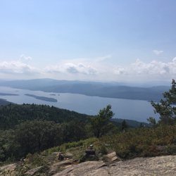
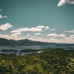
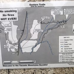
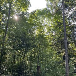
A great hike of moderate difficulty. The summit is lovely, with beautiful views of Lake George and the surrounding mountains. Some areas of the trail are fairly eroded, but there were crews there working to protect the trail and divert water. Even with a full parking lot, the hike was long enough that we didn't see people very often along the way. We saw some families with little ones, but none near the top, so I'm not sure how far they made it. This wouldn't be an easy hike carrying kids, and I don't think most kids under 10 would stick it through to the end. A few portions are pretty steep, so it'd be tough on little legs. The one downside is that apparently Dacy Clearing Road isn't always fully open to vehicles, so rather than parking closer to the trailhead, you may have a few extra miles to walk on a gravel road. This takes your roundtrip from approximately 5 miles to roughly 8. read more


One of the most beautiful places I've hiked in. The view from the summit is spectacular on a sunny summer day, and probably even better in the fall. The hike to the top can be long or short, depending on your skill level, and how you want it to be. If you choose to do a longer hike, you can park at the Hogtown parking lot at the bottom. If you choose the shorter path ( 1.8 mi) to the summit, you must drive further down a dirt path (if the gate to go further is open) for another mile or so and park at the Dacy clearing. The hike itself is not bad. It can be a little rocky and steep, but if you're in average shape, you should be okay. It is for the average to moderate hikers. There were a lot of families with smaller children and dogs when I went. It's definitely something a family can enjoy. If you go on a nice day, I would recommend bringing lunch or snacks with you. It was really nice to eat with a view of the Adirondacks, and Lake George. read more


8 years ago
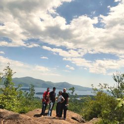
Beautiful moderate hike great for teens and up little ones may have trouble getting to the summit due to the length of the hike took me my girlfriend and father about 1.25hrs. Probably longer if you take the time to enjoy the unique features of the adirondacks. The reward at the top I won't spoil it but it is well worth it. Power up to the top and reap the benefits you will not be disappointed with the views and how peaceful it is up at the top even if there is 20 people already up there. It will give you everything you want out of a hike! Hopefully you enjoy as much as we did! read more

7 years ago
8 years ago
More info about Sleeping Beauty Mountain


Sleeping Beauty Mountain - hiking - Updated May 2026
Best of Fort Ann
People found Sleeping Beauty Mountain by searching for…
Things to Do in Fort Ann, New York
Fireworks in Fort Ann, New York
Playgrounds in Fort Ann, New York
Watch Sunset in Fort Ann, New York
Hiking Trails in Fort Ann, New York
Beautiful Views in Fort Ann, New York
Scenic Views in Fort Ann, New York
Sunset View in Fort Ann, New York
Walking Trails in Fort Ann, New York
Waterfalls and Swimming Holes in Fort Ann, New York
Basketball Courts in Fort Ann, New York
Scenic Overlook in Fort Ann, New York
Lakes & Ponds in Fort Ann, New York
Secret Spots in Fort Ann, New York
Parks for Kids in Fort Ann, New York
Dog Swimming in Fort Ann, New York
River Swimming in Fort Ann, New York
Fishing Spots in Fort Ann, New York
Fun Things to Do at Night in Fort Ann, New York
Easy Hikes in Fort Ann, New York
Off Road Trails in Fort Ann, New York
Waterfalls in Fort Ann, New York
Trending Searches in Fort Ann, NY
Browse Articles
Browse Brands
Related Searches in Fort Ann, NY
Best Fishing Locations and Guides in Fort Ann, New York
Best Nature Trails for Hiking in Fort Ann, New York
Best Places for Horseback Riding in Fort Ann, New York
Best Places for Stunning Views in Fort Ann, New York
Best Waterfalls and Swimming Holes in Fort Ann, New York
Check Out Off Road Trails in Fort Ann, New York
Discover Baseball Fields Around Fort Ann, New York
Discover Dog Friendly Trails to Explore in Fort Ann, New York
Discover Popular Bike Trails in Fort Ann, New York
Discover Scenic Creeks to Explore in Fort Ann, New York
Discover Scenic Mountain Bike Trails Near Fort Ann, New York
Discover Soccer Fields in Fort Ann, New York Near You
Discover Stunning Skyline View Spots in Fort Ann, New York
Discover Top Nature Parks to Visit in Fort Ann, New York
Discover a Hiking Trail in Fort Ann, New York
Discover the Best Beaches in Fort Ann, New York
Discover the Best Night Hike Trails in Fort Ann, New York
Dog-Friendly Hikes With Dogs in Fort Ann, New York
Enjoy the Best Night View Spots in Fort Ann, New York
Enjoy the Best Picnic Spots and Ideas in Fort Ann, New York
Enjoy the Best Tubing Experiences in Fort Ann, New York
Enjoy the Best Walking Trails in Fort Ann, New York
Exciting Cliff Jumping Spots in Fort Ann, New York
Experience Stunning Sunset Views in Fort Ann, New York
Explore Beautiful Parks and Green Spaces in Fort Ann, New York
Explore Easy Hikes Perfect for All in Fort Ann, New York
Explore Family-Friendly Zoos and Wildlife in Fort Ann, New York
Explore Free Picnic Areas Around Fort Ann, New York
Explore Nature Spots Around Fort Ann, New York
Explore Popular Campgrounds Near Fort Ann, New York
Explore Popular Scenic Overlook Points in Fort Ann, New York
Explore Popular Scenic Views Near Fort Ann, New York
Explore Popular View Points Around Fort Ann, New York
Explore Secret Spots Worth Visiting in Fort Ann, New York
Explore Summer Camps for All Ages in Fort Ann, New York
Explore Top Gyms in Fort Ann, New York Now
Explore Volleyball Courts Available in Fort Ann, New York
Explore the Best Boating Spots in Fort Ann, New York
Explore the Best Swimming Holes Around Fort Ann, New York
Explore the Best Trail Options in Fort Ann, New York
Family Friendly Hiking With Kids in Fort Ann, New York
Find Beautiful Views in Fort Ann, New York
Find Cozy Camping Cabins in Fort Ann, New York
Find Parks and Recreation Activities in Fort Ann, New York
Find Top-Rated Waterfalls in Fort Ann, New York Now
Find the Best Playgrounds to Visit in Fort Ann, New York
Find the Best Scenic View Locations in Fort Ann, New York
Find the Best Swimming Pools in Fort Ann, New York Today