Taconic Mountains Ramble Photos


More like Taconic Mountains Ramble
Recommended Reviews - Taconic Mountains Ramble
Start your review...

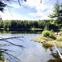
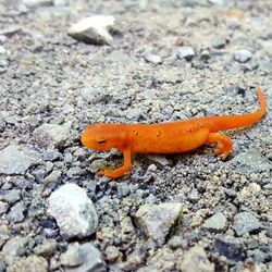
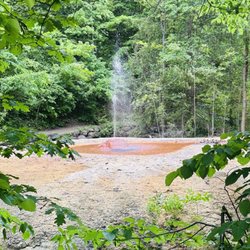
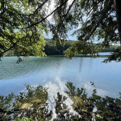
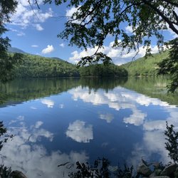
We spent way more time than expected trying to find this place. Loads of winding dirt roads, and hairpin turns brought us to someone's house via our GPS. After 45 minutes of driving, we decided to call it a lost cause, and set our GPS for home, however, several hundred feet ahead we saw a hand painted sign (!) for a state park. We had found it, albeit nearly impossible to find. The park we visited was the Zen Garden. A really nice little place with pools, bridges, a ladder, chairs and a great view. It was worth the effort to find, because we de-stressed and relaxed in the near perfect silence. We also saw plenty of wildlife ranging from frogs and tadpoles to chipmunks and dragonflies. A nice break and escape from civilization. read more


5 years ago
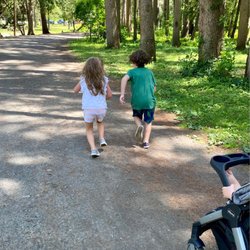
Not particularly difficult to find. Pay attention to the location on your maps app and it should be no problem. Japanese garden was great for little kids. Very beautiful and fun for the to climb around and cross many little bridges. We didn't get to hike too much as it was a touch more difficult than we would like for our very young children. I would highly recommend. read more


6 years ago
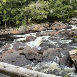
Really terrific little place. You can do all the East and West trails as well as the Japanese garden in 2.5hrs or so if you are in shape. Not well marked for the road you turn onto to get into the park. Near Hubbardton battlefield. read more

More info about Taconic Mountains Ramble
321 St John Rd
Castleton, VT 05735
Directions
Hours
Outdoor Amenities
Other Amenities


Why does Yelp recommend reviews?
1 review that is not currently recommended
The reviews below are not factored into the business's overall star rating.
8 years ago
Taconic Mountains Ramble - hiking - Updated July 2026
Best of Castleton
People found Taconic Mountains Ramble by searching for…
Hiking Trails With Waterfalls in Castleton, Vermont
Things to Do in Castleton, Vermont
Waterfalls and Swimming Holes in Castleton, Vermont
Playgrounds in Castleton, Vermont
Waterfalls in Castleton, Vermont
Beautiful Views in Castleton, Vermont
Parks for Kids in Castleton, Vermont
Camping Sites in Castleton, Vermont
Swimming in Castleton, Vermont
Fun Things to Do With Kids in Castleton, Vermont
Off Leash Dog Hikes in Castleton, Vermont
View Points in Castleton, Vermont
Playgrounds for Kids in Castleton, Vermont
Picnic Areas in Castleton, Vermont
Easy Hikes in Castleton, Vermont
Hiking Trails Kid Friendly in Castleton, Vermont
Public Showers in Castleton, Vermont
Running Trails in Castleton, Vermont
Camping Cabins in Castleton, Vermont
Hiking With Kids in Castleton, Vermont
Picnic Spots in Castleton, Vermont
Scenic Views in Castleton, Vermont
Trending Searches in Castleton, VT
Berry Picking near Taconic Mountains Ramble
Campgrounds near Taconic Mountains Ramble
Cliff Jumping near Taconic Mountains Ramble
Fireworks near Taconic Mountains Ramble
Kayak Rental near Taconic Mountains Ramble
Lakes near Taconic Mountains Ramble
Lakes & Ponds near Taconic Mountains Ramble
Off Road Trails near Taconic Mountains Ramble
Picnic Areas near Taconic Mountains Ramble
Playgrounds near Taconic Mountains Ramble
River Tubing near Taconic Mountains Ramble
Scenic Drive near Taconic Mountains Ramble
Secret Spots near Taconic Mountains Ramble
Strawberry Picking near Taconic Mountains Ramble
Swimming Holes near Taconic Mountains Ramble
Browse Articles
Browse Nearby
Browse Brands
Related Cost Guides
Related Searches in Castleton, VT
Affordable Canoe Rental Options in Castleton, Vermont
Affordable Kayak Rental Services in Castleton, Vermont
Best Fishing Locations and Guides in Castleton, Vermont
Best Off Leash Dog Parks in Castleton, Vermont
Best Places for Horseback Riding in Castleton, Vermont
Best Pontoon Boat Rentals Near Castleton, Vermont
Best Sledding Spots and Fun in Castleton, Vermont
Best Things to Do on a Rainy Day in Castleton, Vermont
Browse Top Hotels in Castleton, Vermont for Your Stay
Check Out Off Road Trails in Castleton, Vermont
Discover Kids Indoor Play Area Venues in Castleton, Vermont
Discover Lakes & Ponds to Explore in Castleton, Vermont
Discover Top Boat Tours in Castleton, Vermont for All Ages
Discover the Best Beaches in Castleton, Vermont
Discover the Best Running Track in Castleton, Vermont
Dog-Friendly Hikes With Dogs in Castleton, Vermont
Enjoy Hiking Adventures in Castleton, Vermont
Enjoy a Relaxing Bed & Breakfast Experience in Castleton, Vermont
Enjoy the Best Tubing Experiences in Castleton, Vermont
Experience the Best Family Fun in Castleton, Vermont for All
Explore Beautiful Parks and Green Spaces in Castleton, Vermont
Explore Bike Rentals Throughout Castleton, Vermont
Explore Family-Friendly Zoos and Wildlife in Castleton, Vermont
Explore Free Things to Do Around Castleton, Vermont
Explore Fun Activities to Do in Castleton, Vermont
Explore Hotels & Travel Options in Castleton, Vermont
Explore Jet Skis for Sale or Rent in Castleton, Vermont
Explore Landmarks & Historical Buildings in Castleton, Vermont
Explore Popular Boat Charters Near Castleton, Vermont
Explore Popular Campgrounds Near Castleton, Vermont
Explore Popular RV Parks Around Castleton, Vermont
Explore Popular Recreation Centers Around Castleton, Vermont
Explore Secret Spots Worth Visiting in Castleton, Vermont
Explore Summer Camps for All Ages in Castleton, Vermont
Explore Top Dog Parks in Castleton, Vermont Near You
Explore Top Gyms in Castleton, Vermont Now
Explore the Best Boating Spots in Castleton, Vermont
Explore the Scenic River in Castleton, Vermont
Find Fun Kids Activities Outdoor in Castleton, Vermont
Find the Best Party Boat Experiences in Castleton, Vermont
Find the Best Playgrounds to Visit in Castleton, Vermont
Find the Best Swimming Pools in Castleton, Vermont Today
Fun Things for Kids in Castleton, Vermont
Hiking Trails With Waterfalls in Castleton, Vermont
Popular Fishing Spots to Explore in Castleton, Vermont
Popular Kids Activities in Castleton, Vermont
Popular Places to Take Pictures in Castleton, Vermont
Popular Things to Do in Castleton, Vermont