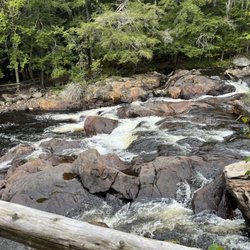
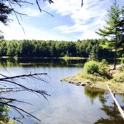
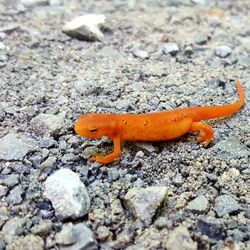
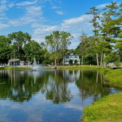
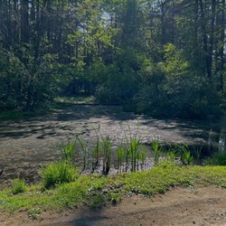
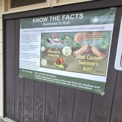
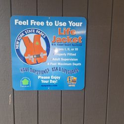
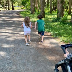
Hackensack Mountain Trailhead Photos


More like Hackensack Mountain Trailhead
Recommended Reviews - Hackensack Mountain Trailhead


More info about Hackensack Mountain Trailhead
93 Schroon River Rd
Warrensburg, NY 12885
Directions
Hours
Outdoor Amenities


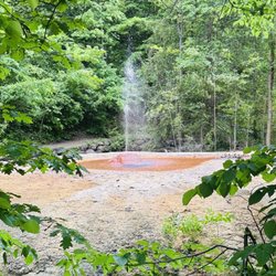


Hackensack Mountain Trailhead - parks - Updated July 2026
Best of Warrensburg
People found Hackensack Mountain Trailhead by searching for…
Hiking in Warrensburg, New York
Things to Do in Warrensburg, New York
Playgrounds in Warrensburg, New York
Hiking Trails in Warrensburg, New York
Running Trails in Warrensburg, New York
Parks for Kids in Warrensburg, New York
View Points in Warrensburg, New York
Hiking With Kids in Warrensburg, New York
Playgrounds for Kids in Warrensburg, New York
Easy Hikes in Warrensburg, New York
Walking Trails in Warrensburg, New York
Scenic Views in Warrensburg, New York
Picnic Areas in Warrensburg, New York
Places to Take Pictures in Warrensburg, New York
Parks With Pull Up Bars in Warrensburg, New York
Waterfall in Warrensburg, New York
Scenic Overlook in Warrensburg, New York
Hiking Trails Kid Friendly in Warrensburg, New York
State Parks in Warrensburg, New York
Off Road Trails in Warrensburg, New York
Beautiful Views in Warrensburg, New York
Fall Foliage in Warrensburg, New York
Trending Searches in Warrensburg, NY
Baseball Fields near Hackensack Mountain Trailhead
Boardwalk near Hackensack Mountain Trailhead
Boat Rental near Hackensack Mountain Trailhead
Cliff Jumping near Hackensack Mountain Trailhead
Day Trips near Hackensack Mountain Trailhead
Dog Friendly Beaches near Hackensack Mountain Trailhead
Fireworks near Hackensack Mountain Trailhead
Fishing Spots near Hackensack Mountain Trailhead
Jet Ski Rental near Hackensack Mountain Trailhead
Kayak Rental near Hackensack Mountain Trailhead
Lakes near Hackensack Mountain Trailhead
Paddle Boat Rentals near Hackensack Mountain Trailhead
Places To Swim near Hackensack Mountain Trailhead
River Swimming near Hackensack Mountain Trailhead
River Tubing near Hackensack Mountain Trailhead
Splash Pad near Hackensack Mountain Trailhead
Strawberry Picking near Hackensack Mountain Trailhead
Sunbathing near Hackensack Mountain Trailhead
Swimming Holes near Hackensack Mountain Trailhead
Swimming Lakes near Hackensack Mountain Trailhead
U Pick Farms near Hackensack Mountain Trailhead
Browse Articles
Browse Nearby
BEST of Warrensburg, New York Restaurants near Hackensack Mountain Trailhead
BEST of Warrensburg, New York Playgrounds near Hackensack Mountain Trailhead
BEST of Warrensburg, New York Coffee near Hackensack Mountain Trailhead
BEST of Warrensburg, New York Things to Do near Hackensack Mountain Trailhead
BEST of Warrensburg, New York Picnic Areas near Hackensack Mountain Trailhead
BEST of Warrensburg, New York Campgrounds near Hackensack Mountain Trailhead
BEST of Warrensburg, New York Breakfast near Hackensack Mountain Trailhead
BEST of Warrensburg, New York Sledding near Hackensack Mountain Trailhead
BEST of Warrensburg, New York Snow Tubing near Hackensack Mountain Trailhead
Browse Brands
Related Searches in Warrensburg, NY
Best Fun Things to Do in Warrensburg, New York
Best Water Parks for Kids in Warrensburg, New York
Check Out Great Playgrounds in Warrensburg, New York
Check Out Off Road Trails in Warrensburg, New York
Discover Baseball Fields Around Warrensburg, New York
Discover Free Parking Options in Warrensburg, New York
Discover Fun Activities to Do in Warrensburg, New York
Discover Popular Photo Spots in Warrensburg, New York
Discover Top Nature Parks to Visit in Warrensburg, New York
Discover the Best Beaches in Warrensburg, New York
Enjoy Tent Camping Spots Around Warrensburg, New York
Enjoy a Dog Beach Day in Warrensburg, New York
Enjoy the Best Family Activities in Warrensburg, New York
Enjoy the Best Picnic Spots and Ideas in Warrensburg, New York
Enjoy the Best Walking Trails in Warrensburg, New York
Explore Free Things to Do Around Warrensburg, New York
Explore Kid Friendly Places and Events in Warrensburg, New York
Explore Landmarks & Historical Buildings in Warrensburg, New York
Explore Popular Campgrounds Near Warrensburg, New York
Explore Popular Picnic Areas Around Warrensburg, New York
Explore Popular RV Parks Around Warrensburg, New York
Explore Popular Recreation Centers Around Warrensburg, New York
Explore Popular Scenic Views Near Warrensburg, New York
Explore Scenic Lakes to Visit in Warrensburg, New York
Explore Summer Camps for All Ages in Warrensburg, New York
Explore Top Dog Parks in Warrensburg, New York Near You
Explore Top Gyms in Warrensburg, New York Now
Explore the Best Swimming Holes Around Warrensburg, New York
Find Beautiful Views in Warrensburg, New York
Find Top Skate Parks in Warrensburg, New York for All Skill Levels
Find Top Skating Rinks in Warrensburg, New York for All Ages
Find the Best Parks for Picnics in Warrensburg, New York
Find the Best Swimming Pools in Warrensburg, New York Today
Have Fun at a Splash Pad in Warrensburg, New York
Hiking Trails With Waterfalls in Warrensburg, New York
Locate a Public Shower Facility in Warrensburg, New York
Perfect Spots to Watch Sunset in Warrensburg, New York
Picnic Areas With BBQ Pits Available in Warrensburg, New York
Popular Fishing Spots to Explore in Warrensburg, New York
Popular Kids Activities in Warrensburg, New York
Popular Outdoor Activities to Try in Warrensburg, New York
Popular Places to Take Pictures in Warrensburg, New York
Popular Things to Do in Warrensburg, New York
Popular Things to See in Warrensburg, New York
Top Hiking Trails to Explore in Warrensburg, New York
Top Swimming Lakes to Enjoy in Warrensburg, New York
Top Swimming Spots and Pools in Warrensburg, New York
Top Things to Do With Kids in Warrensburg, New York
Top-Rated Basketball Courts to Play at in Warrensburg, New York