Cancel

    Open app

    Search

    Moxham Mountain Trail

    3.0 (1 review)

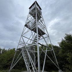
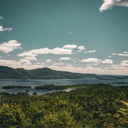
    Moxham Mountain Trail Photos

    You might also consider

    Recommended Reviews - Moxham Mountain Trail

    Your trust is our priority, so businesses can't pay to alter or remove their reviews. Learn more about reviews.
    Yelp app icon
    Browse more easily on the app
    Review Feed Illustration
    Photo of Ryan F.
    519
    2052
    7706

    6 years ago

    Helpful 0
    Thanks 0
    Love this 0
    Oh no 0

    Verify this business for free

    People searched for Hiking 137 times last month within 15 miles of this business.

    Verify this business

    Sleeping Beauty Mountain - Mid October, Sleeping Beauty Summit.

    Sleeping Beauty Mountain

    (5 reviews)

    A great hike of moderate difficulty. The summit is lovely, with beautiful views of Lake George and…read morethe surrounding mountains. Some areas of the trail are fairly eroded, but there were crews there working to protect the trail and divert water. Even with a full parking lot, the hike was long enough that we didn't see people very often along the way. We saw some families with little ones, but none near the top, so I'm not sure how far they made it. This wouldn't be an easy hike carrying kids, and I don't think most kids under 10 would stick it through to the end. A few portions are pretty steep, so it'd be tough on little legs. The one downside is that apparently Dacy Clearing Road isn't always fully open to vehicles, so rather than parking closer to the trailhead, you may have a few extra miles to walk on a gravel road. This takes your roundtrip from approximately 5 miles to roughly 8.

    One of the most beautiful places I've hiked in. The view from the summit is spectacular on a sunny…read moresummer day, and probably even better in the fall. The hike to the top can be long or short, depending on your skill level, and how you want it to be. If you choose to do a longer hike, you can park at the Hogtown parking lot at the bottom. If you choose the shorter path ( 1.8 mi) to the summit, you must drive further down a dirt path (if the gate to go further is open) for another mile or so and park at the Dacy clearing. The hike itself is not bad. It can be a little rocky and steep, but if you're in average shape, you should be okay. It is for the average to moderate hikers. There were a lot of families with smaller children and dogs when I went. It's definitely something a family can enjoy. If you go on a nice day, I would recommend bringing lunch or snacks with you. It was really nice to eat with a view of the Adirondacks, and Lake George.

    Cascade Mountain

    Cascade Mountain

    (17 reviews)

    One of my favorite hikes in the high peak region -- it's a great starter one to those interested in…read moredoing a high peak. You combine it with Porter to get two mountains off your list, for the "physical price" of doing one! This is a gentle mountain, but still should not be taken lightly as it is a high peak and it will challenge you, no matter how fit you might be. I've climbed this in the summer 2-3 times and at least 2-3 times in the winter. I prefer doing it in the winter personally for less crowds and beautiful ice covered pine sights and an Arctic wonderland, but either one is gorgeous. Parking is free, but limited...come early to try to snag a spot. Doing both mountains will only add an hour or so to your total hike time, so don't be afraid to tackle both even if you might be tired after hitting Cascade. I think Cascade is good to hit first and then head over to Porter, but honestly either one will work well. Plan 3-8hours round trip, depending on your level of physical ability. Come prepared and know the conditions, talk to the rangers or other hikers so you know what to expect.

    One of the 46 high peaks and known to be the easiest and quickest round trip hike! This means that…read moreyou should expect it to be the busiest as well! Early birds will get the parking spots, but during the warmer season, early may mean arriving before 6:30am for optimal parking! A phenomenal panoramic view that gives a great view from anywhere you decide to post up on the top for a quick snack. You can also hike this to mount porter which is another high peak of the 46er club! For avid hikers/trail runners, you could really round trip in under 2 hours. For new mountain hikers, best to expect a 4-5 hour trek for those who aren't use to the 2000 feet of elevation gain.

    Prospect Mountain

    Prospect Mountain

    (58 reviews)

    Super cool and beautiful place to hike there are an abundance of trails a few picnic areas and for…read morethose of you who don't wanna hike you can drive up to the top! Currently it's free to drive up as when I passed the toll booth it stated so! This one will be short and sweet as it's just beautiful here in the trees overlooking the lake! Overall this was an awesome find and the view the breeze blowing through my hair was satisfying beyond any means as this chill relaxing spot was much needed!

    This is an excellent autumn hike with amazing views. Although short at only two miles from…read moretrailhead to summit, you'll need proper shoes for this hike and you will warm up due to the steep grade and moderate rock scrambling. We took the red trail all the way to the top and we took the blue trail on the way down (it merges with the red trail). I'm giving four stars because the trail marking are really good, except where they aren't and just disappear for a while or entirely. The red trail is mostly well marked, though there were still times when we just had to keep heading up the mountain because we couldn't find the next marker. On our way down, the blue trail was really, really well marked until it just stopped and we could not find another marker. I'm not a fan of going off trail because I know it can be dangerous and it can be damaging to local ecosystems, but without a clear trail to follow and nearly a mile into the woods, we did the best we could (kept heading downhill and to the right hoping to find the red trail, but eventually finding the road anyway). If you start at the trailhead, you will walk up metal stairs and onto a walkway over the highway. From there, you'll follow the trail about a mile up where you will find a road. Beware of traffic, cross the road, and you'll have another mile to go to reach the summit (you can take red or blue trail) where there is a parking lot and great viewing.

    Moxham Mountain Trail - hiking - Updated May 2026

    Loading...
    Loading...
    Loading...