Shieling Forest Photos


You might also consider
More like Shieling Forest
Recommended Reviews - Shieling Forest
Start your review...

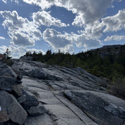
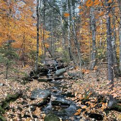
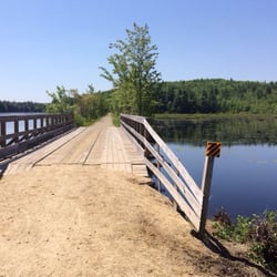
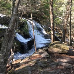
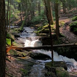
Great location for hiking and a great asset to the community. There is parking for probably 12+ cars and the non profit organizations use their facilities for meetings. Hike is pretty mild with some crossing and mostly shaded area beautiful scene for both the summer and winter. read more


3 years ago
More info about Shieling Forest
395 Old Street Rd
Peterborough, NH 03458
Directions
(603) 431-6774
Call Now
Hours
Outdoor Amenities


Shieling Forest - hiking - Updated June 2026
Best of Peterborough
People found Shieling Forest by searching for…
Things to Do in Peterborough, NH
Easy Hikes in Peterborough, NH
Hiking Trails in Peterborough, NH
Scenic Views in Peterborough, NH
Walking Trails in Peterborough, NH
Off Leash Dog Hikes in Peterborough, NH
Places to Swim in Peterborough, NH
Running Trails in Peterborough, NH
Off Road Trails in Peterborough, NH
Swimming Holes in Peterborough, NH
Waterfalls in Peterborough, NH
Night Hiking in Peterborough, NH
Watch Sunset in Peterborough, NH
Fun Things to Do With Kids in Peterborough, NH
Lakes & Ponds in Peterborough, NH
Jogging Trails in Peterborough, NH
Open Today in Peterborough, NH
Attractions in Peterborough, NH
Waterfall Hike in Peterborough, NH
Trending Searches in Peterborough, NH
Amusement Parks near Shieling Forest
Black Owned Nail Salons near Shieling Forest
Boat Rental near Shieling Forest
Cliff Jumping near Shieling Forest
Dog Friendly Trails near Shieling Forest
Fishing Spots near Shieling Forest
Free Kids Activities near Shieling Forest
Jet Ski Rental near Shieling Forest
Outdoor Activities near Shieling Forest
Pick Your Own Farms near Shieling Forest
Public Shower near Shieling Forest
Running Trails near Shieling Forest
Scenic Drive near Shieling Forest
Secluded Spots near Shieling Forest
Soccer Store near Shieling Forest
Splash Pad near Shieling Forest
Strawberry Picking near Shieling Forest
Sunrise View near Shieling Forest
Swimming Holes near Shieling Forest
Swimming Lakes near Shieling Forest
Swimming Pools near Shieling Forest
Watch Sunset near Shieling Forest
Browse Articles
Browse Nearby
Browse Brands
Related Searches in Peterborough, NH
Affordable Kayak Rental Services in Peterborough, New Hampshire
Best Fishing Locations and Guides in Peterborough, New Hampshire
Best Places for Horseback Riding in Peterborough, New Hampshire
Best Sledding Spots and Fun in Peterborough, New Hampshire
Best Waterfalls and Swimming Holes in Peterborough, New Hampshire
Check Out Off Road Trails in Peterborough, New Hampshire
Discover Lakes & Ponds to Explore in Peterborough, New Hampshire
Discover Popular Photo Spots in Peterborough, New Hampshire
Discover a Hiking Trail in Peterborough, New Hampshire
Discover the Best Night Hike Trails in Peterborough, New Hampshire
Dog-Friendly Hikes With Dogs in Peterborough, New Hampshire
Enjoy Camping Adventures Around Peterborough, New Hampshire
Enjoy Exciting Mountain Biking Adventures in Peterborough, New Hampshire
Enjoy Tent Camping Spots Around Peterborough, New Hampshire
Enjoy the Best Tubing Experiences in Peterborough, New Hampshire
Enjoy the Best Walking Trails in Peterborough, New Hampshire
Exciting Cliff Jumping Spots in Peterborough, New Hampshire
Explore Beautiful Parks and Green Spaces in Peterborough, New Hampshire
Explore Bike Rentals Throughout Peterborough, New Hampshire
Explore Easy Hikes Perfect for All in Peterborough, New Hampshire
Explore Fun Activities to Do in Peterborough, New Hampshire
Explore Popular Campgrounds Near Peterborough, New Hampshire
Explore Popular RV Parks Around Peterborough, New Hampshire
Explore Popular Scenic Overlook Points in Peterborough, New Hampshire
Explore Scenic Lakes to Visit in Peterborough, New Hampshire
Explore Top Dog Parks in Peterborough, New Hampshire Near You
Explore the Best Beach Spots in Peterborough, New Hampshire
Explore the Best Boating Spots in Peterborough, New Hampshire
Family Friendly Hiking With Kids in Peterborough, New Hampshire
Find Beautiful Views in Peterborough, New Hampshire
Find Popular Ziplining Spots Around Peterborough, New Hampshire
Find the Best Playgrounds to Visit in Peterborough, New Hampshire
Find the Best Scenic View Locations in Peterborough, New Hampshire
Hiking Trails With Waterfalls in Peterborough, New Hampshire
Off Leash Dog Hiking Trails in Peterborough, New Hampshire
Plan a Scenic Drive Route Near Peterborough, New Hampshire
Popular Fishing Spots to Explore in Peterborough, New Hampshire
Popular Outdoor Activities to Try in Peterborough, New Hampshire
Popular Things to Do in Peterborough, New Hampshire
Safe River Swimming Areas in Peterborough, New Hampshire
Safe and Fun Parks for Kids in Peterborough, New Hampshire
Top Climbing Spots and Gyms in Peterborough, New Hampshire
Top Paddleboarding Activities in Peterborough, New Hampshire
Top Places for Snorkeling in Peterborough, New Hampshire
Top Playgrounds for Kids to Enjoy in Peterborough, New Hampshire
Top Running Trails to Explore in Peterborough, New Hampshire
Top Swimming Lakes to Enjoy in Peterborough, New Hampshire
Top Things to Do With Kids in Peterborough, New Hampshire
Visit Popular BBQ Park Locations in Peterborough, New Hampshire
Walk Dog Friendly Hiking Trails in Peterborough, New Hampshire
People who viewed Shieling Forest also viewed
Heads Pond Trail
3 reviews
Chesterfield Gorge
1 review
Keene Rail Trails
1 review
Rockingham Recreational Trail, Depot Road
1 review
Garwin Falls
1 review
Chesterfield Gorge
6 reviews
Otter Brook State Park
1 review
Susan N. McLane Audubon Center and Silk Farm Wildlife Sanctuary
1 review
Edward Macdowell Dam
1 review
Lake Potanipo
2 reviews