1. Railroad Square

0

Keene, NH

Cancel

Open app

Search

Railroad Square

5.0 (1 review)

Railroad Square Photos

Recommended Reviews - Railroad Square

Your trust is our priority, so businesses can't pay to alter or remove their reviews. Learn more about reviews.
Yelp app icon
Browse more easily on the app
Review Feed Illustration
Photo of Jeremy J.
1821
6712
76971

5 years ago

Helpful 18
Thanks 0
Love this 19
Oh no 0

Verify this business for free

People searched for Parks 103 times last month within 15 miles of this business.

Verify this business

Monadnock State Park - White Dot trail

Monadnock State Park

4.7(43 reviews)
10.6 mi

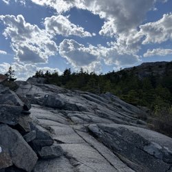
I have hiked A LOT of mountains in New England but I had never hiked the mountain it seemed like…read moreeveryone I knew had hiked. Fortunately, I had the opportunity to change that and now I can see what all the hubbub is about. What a great mountain with fantastic views. After doing a bit of homework, I realized it was in my best interest to make a park reservation so that I could secure a parking space for the day at the start of the trailheads I was eyeing for the next day. As one of the most hiked mountains (in the world?), this park reports hosting a massive number of visitors each year and from first hand experience, I can attest that it is a busy one. The $15 was worth the peace of mind and my ability to pull right in and hop onto the trail. I had a hard time locating their "opening hours" but I arrived shortly after 8am with about 20 cars there ahead of me. I really appreciated the park ranger that checked me in for my reservation at the Poole Road entrance. Incredibly welcoming, inquisitive about plans, quick to offer advice for the best experience, and even shared a weather update (30 mph+ winds at the summit that day) before I was on my way. Supplied with a paper map and an idea which trails would be least busy and most scenic, I felt well-prepared for an enjoyable morning on the mountain. I opted to start out on the White Dot Trail. For less crowds, I branched off to the Cascade Link, then hooked a left onto the Red Spot Trail which delivered me to the summit. Gaining elevation at a slow and steady pace, I found the whole climb quite enjoyable. I rejoined the crowd at the summit but still with plenty of room for photos of the scenery and some quiet time to enjoy a snack. Wide open, bald summit with views for days. I would have stayed longer if not for the strong winds. After nestling in between the rocks away from the air currents to enjoy a brief snack, I was on my way down the mountain via the White Cross Trail. There were even glimpses of Boston in the distance! Each trail was clearly marked by it namesake (literally white dots, red dots, and white crosses) which made wayfinding a breeze. That said, I still came across a party or two that had gotten turned around. Do your homework, connect to a trail app if you have the means, practice your map reading skills, and heed the recommendations of the rangers and you should have the basic tools you need to keep you on track and still smiling. So many trails and options that can keep you coming back for more. The visitor center at this entrance was a welcome amenity, restrooms, and all. I cannot comment on the park store because it was closed for lunch when I was finishing up. All in all I got in just under 5 miles using the route that I did. Beautiful peak, beautiful day. Highly recommend.

Great day hike and not for those with weak ankles! Took the white dot trail up and used the white…read morecross trail to come down. Forgot the bug spray which would have kept the critters at bay with much of the trail having slow or puddled water. Parking wasn't too crowded, $15 for access to park. Snack and gift shop in the lot and the headquarters building just up the trail. Great restroom facility to use prior to starting the hike as well. Very rocky terrain all the way up, clearly marked with white dots (crosses as well for the return). Enjoyed the fact there were multiple volunteer guides hiking or positioned at locations (one steady at fork for dot/cross) if needed. Had low reception all through the hike for emergencies as well. Beautiful views towards the top and of course 360 once on the summit. Definitely worth the time spent. Pack in pack out, bring water and snacks along with the spray (both bug and sun)! Enjoyed a quick snack on the top with the views and a quick tsp of the marker before heading back down. Time to get up to the peak, what are you waiting for?!

Photos
Monadnock State Park - Along or near the White Dot Trail

Along or near the White Dot Trail

Monadnock State Park - Trails

Trails

Monadnock State Park

See all

Mt. Ascutney State Park

Mt. Ascutney State Park

4.5(20 reviews)
36.3 mi

This one will be hard to relive... its been two weeks and we still are emotionally and physically…read morerecovering from this hike. We are still to this day on our hands and knees picking up the pieces to a broken relationship. Caused by yes you guessed it, Mt. Ascutney. We wake up, eager to start our day, After a hectic dinner (peep Sawtooth review) we were ready for a fresh start, and dom finally took off the mascot costume. "I'm starving, I haven't eaten since the DOUBLE burger last night." "Theres no time, we need to conquer him." We both look in the distance to Mt. Ascutney and we are on the same page. We need a WIN. We probably hop skip and hike our asses to the parking lot where we drive over. Not much there. We get out and are met with a ridiculously humid day after the weather app misinformed us about a 78 degree day. with a slight chance of RAINNNNNN (No Snapple Element) We start on our expedition up this treacherous path. Our first warning comes to us. A woman running for her life to her car, pratically levitating (No Dua Lipa) down the mountain as if a mysterious force (mint) was calling for her. We turn to each other and figure "Hey this might not be too bad." (look into camera) little did we know she was just estatic to be freed from the shackles of Mt. Ascutney. We shake off (No Taylor) the first step jitters and get on our merry way. As we continue up the mountain, I begin throwing distractions at Dom so he doesnt notice the silence. "How was your week?" (I didn't care one bit, just focusing on my breathing pattern) Slowly but surely the altitude catches up with us, guys we are at LEAST 1,000 feet above sea level. And we might as well jumped into that same sea with the amount of sweat we were producing. Embarassed we let yum yums pass... We stop, to admire the view and kill time. Little did we know this mountain was killing us. Frazzled, our thoughts begin getting the best of us. I have no other choice but to make up scenarios where I kill Dom. Looking at each other we know what had to be done, we cant conquer this mountain we must turn back. DID YOU REALLY THINK WE DID THAT. IF YOU DID, DONT READ THE REST OF THIS REVIEW YOU DONT KNOW THE FIRST THING ABOUT US. We say, hey if people need help, we help. We are people, and we need help. After taking a measily four steps down the mountain we remember who the FUCK we are. We are Ariaanddom. What would our yelp followers, friends, family, service workers, first responders (fuck it) and most importantly John Taboada think of us. We persevered up this mountain. For another .2 miles and then we realize this was crazy people shit. And went and got a mint. We tapped into sandwiches too, please take a look at our next review.

We pulled up to the ticket booth just off the main road at around 2:15 p.m. on a weekday. After…read morepaying our $5 per person, it took another 15 - 20 minutes to drive up the twisting road to the parking lot closest to the summit. There was only one other car parked there, though the lot looked like it could hold 35 - 40 cars. The hike from there was then a minimum of 0.6 miles (rocky and occasionally steep) to a lookout tower (25 feet tall, maybe). The summit was another 0.1 miles but probably wasn't even as high as the tower. We took the Slot trail up since it appeared to be more gradual (but was a bit longer). On the way back, we opted for the other option: the Slab trail (which was steeper but had steps cut into the dirt or fashioned from large stones, in spots). I would classify this hike as short but moderate. The tower views were pretty nice. It probably took us a bit over an hour to hike up and back.

Photos
Mt. Ascutney State Park - From the tower - 1.

From the tower - 1.

Mt. Ascutney State Park - Along the trail.

Along the trail.

Mt. Ascutney State Park - Gorgeous views!

See all

Gorgeous views!

Living Memorial Park

Living Memorial Park

4.0(2 reviews)
16.6 mi

Driving by and I saw this wooden covered bridge so we had to pull over and check it out! So glad…read morewe did, The bridge is located right with this cute,well cared for small park. Well maintained trees, bushes and plants. Love to see how well they take care of the landscape here, also lots of garbage cans around. The park even has a few benches to sit and relax on. The wooden covered bridge was very cool to see and walk through. No cars allowed.... so this allows you to walk right inside the bridge ( love that there is a picnic bench inside too)The bridge goes over a small stream loaded with rocks and wildlife. On the outside of the bridge there are also another pathway to get a closer look at the stream. Very cute area perfect for a quick lunch break and rest before getting back on the road.

Living Memorial Park is a local gem. Just past the quaint Creamery Covered Bridge off Rt 9, you'll…read morefind this park, central to the Brattleboro community. On one side of the entrance around the corner from the public pool there are play areas, basketball hoops, a gazebo and benches. Residents and non-residents alike may use the pool and small children's water park for a small fee. There are public bathrooms, but they are what you would expect from an old, public park bathroom...built with concrete blocks and minimally cleaned (ie: kinda gross), but at least they're available. On the other side of the entrance is a baseball field. In the winter, the hill is a popular spot for sledding and skiing. There is a T-bar and the capacity to make snow. Many local children get their start skiing here because it is incredibly inexpensive to buy a day pass and free for children under 5. If you venture further up the hill you'll find other fields, an ice skating rink, a small outdoor stage, and a picnic pavilion. The views from the top of the hill are beautiful, and from the top there are hiking trails through the woods around the park.

Photos
Living Memorial Park

See all

Railroad Square - parks - Updated November 2026

Loading...
Loading...
Loading...