Cancel

    Open app

    Search

    Keene Rail Trails

    5.0 (1 review)

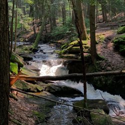
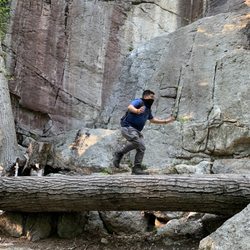
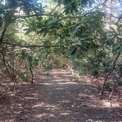
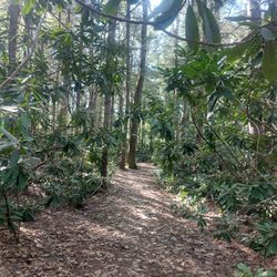
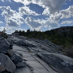
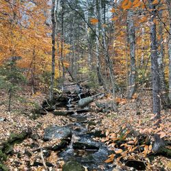
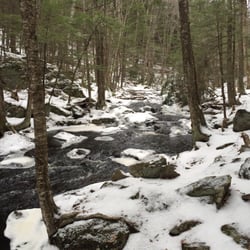
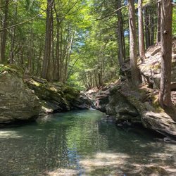
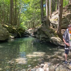
    Keene Rail Trails Photos

    Recommended Reviews - Keene Rail Trails

    Your trust is our priority, so businesses can't pay to alter or remove their reviews. Learn more about reviews.
    Yelp app icon
    Browse more easily on the app
    Review Feed Illustration

    11 years ago

    Helpful 3
    Thanks 0
    Love this 1
    Oh no 0

    Verify this business for free

    People searched for Hiking 218 times last month within 15 miles of this business.

    Verify this business

    Buttermilk Falls

    Buttermilk Falls

    4.5(12 reviews)
    41.3 mi

    Wow ! What a hidden gem ! We were visiting Ludlow VT and saw this fall . Kids wanted to enjoy…read morewater and this was a perfect choice for us . The water was colddddddddddd though. Ufff . Very cold . The first dip was tough ! Later once you get use of it , it felt a bit better . Pathway was a bit crazy , in some places .it is about a 2 mile walk but we just went not too far : .. the lower and middle falls is also accessible from car parking lots outside . Parking is outside and sometimes you have to park 5-8 mins away from the falls . Not much of restrooms around . Lots of dogs in the water :) It was an amazing tint though ! Loved it . 5 stars !

    As we were staying near Ludlow, I had put this on our schedule as a "check it out whenever time…read morepermits" item. We drove back after visiting some places to the north, and were passing this around 4 p.m. so we checked it out. This was in early October and the sun was just starting to go down. Though it was pre-dusk, it would be better to visit this site in full sunlight. There are 3 separate falls (the creatively named upper, middle, and lower). You access them from the main highway via a side road that starts as paved but soon becomes (good) dirt/gravel. The total length is less than 2 miles. You first get to a wide spot / parking area from which you can access the middle and lower falls. A trail leads down a hill where you must choose which falls to visit. The middle falls is impressive. It is probably the easiest one to access. The area from which you have the best view is a bit rocky, but navigable. It makes for nice photos. The lower falls appeared accessible from a side trail that descended a bit more steeply. You can also see it from above (somewhat) without descending. It appeared smaller and less photogenic than the middle falls. We then drove another 1/4 mile up the road (to its end) to check out the upper falls. There is a sharp short descent from the road to the top of the falls. It appeared to have a fairly large pool at the bottom and a flat dirt/sand area where some people had laid out a blanket for a picnic. The light was fading more so we skipped walking down the relatively gentle slope to check it out further. If you are in the area and have time, this is a nice spot to visit. It is within 3 miles of Ludlow. I cannot comment on what the swimming is like, but I saw references to that online (during summers, I guess).

    Photos
    Buttermilk Falls
    Buttermilk Falls
    Buttermilk Falls

    See all

    Monadnock State Park - Trail head

    Monadnock State Park

    4.7(41 reviews)
    10.6 mi

    For a mere $15 cash you can access some pristine hiking opportunities. I have trekked these grounds…read morein all 4 seasons. Each has its own unique set of challenges and joys. Whether it is ice and snow with trax on or wet leaves on a steep incline, you can bet on a challenge. The most commonly used trail up the mountain is the 2 mile (one way), White Dot trail. It is well marked and easily followed. The elevation gain is rapid, as this is a shorter hike. The views are absolutely stellar from the summit. There is a small shop at the base and you receive a map upon entry with basic guidelines and trails. If you are into the outdoors, I highly recommend this spot! Laces up!

    Things to note before reading this: 1) I'm a beginner hiker…read more2) My legs get me from point A to B but they are not strong once resistance is involved lol so leg day is always my biggest challenge and because of this... 3) I'm always the slow hiker of the group and I like to take my time I came here last year on a Saturday at the end of October. I went with some friends who have hiked this mountain before. I went into this hike without looking up what to expect, I knew it was going to be challenging but boy was I in for a surprise. I just went with what my friends who invited me said. So the parking at the first trailhead was full and found parking at the second trailhead (Gilson Pond parking), which is the Red Dot Trail, and was our group's first time doing. It was my first official mountain hike. The Red Dot trail was quite a challenge since it involved a lot of climbing once you got to the midway point. There was a boulder that took me a while to overcome and after that there was more to climb and "oh my God" (Janice from Friends voice) reactions to seeing these climbs. We started at around 9am and stopped just right below the peak at 12pm. One person in our group completed the hike and went up to the peak. We had breakfast as we experienced the view then we took the White Dot Trail back down and connected to the Red Dot Trail to get back to the Gilson Pond Parking Lot I think we got back to the car close to 3pm. It was a sunny 60-70 degree morning and I was mostly in a t-shirt throughout the entire hike but I needed my jacket at the peak because of that windchill and the cloud cover. I was sore everywhere for the next week. ---------- Fast forward to this October, my husband and another friend wanted to do a Fall/Autumn hike. I found a site with all the New England hikes and experience levels. I saw that Mount Monadnock was in the advanced category and I very proud of myself for doing it last year. Anyway they decided on Mount Monadnock the night before. I still had trauma from last year's experience so I did my research this time and we decided on the White Dot Trail. We went yesterday which was a Saturday on the holiday weekend. Clear sunny day. The parking for the White Dot Trail was full again and the park ranger at the gate said all 3 parking lots are full from reservations. So reservations are encouraged! We drove all this way and were determined to do a hike so thankfully he suggested we could do the Dublin Trail which is about the same distance to the peak as the White Dot Trail. The Dublin Trail trailhead is a first come first serve parking lot so it's free parking and there's a donation box for the park that is welcomed. Based on my research the night before, someone on Reddit said this is a nice trail for beginners and I can confirm that it is since I am still a beginner hiker. It was a gentler incline, it still worked my legs, than the Red Dot Trail with easier /moderate climbs. We started at 9am again and got to peak at 10:50am. We left the peak at 11:30 and got back to the car at 1:10pm. So roughly 3hrs roundtrip, including stopping to take photos on the way up and down- 4hrs including a break to eat. It was a chilly morning in the 60s, I started in 3 layers (tshirt, a winter running long-sleeve, and a thermal jacket) at the start and by 30 minutes in I was down to my tshirt. I was in a t-shirt for most of the hike, closer to the peak I had to add a layer. We were able to find a spot on the peak to shield us from the wind because it was ripping. I was fine in the two layers with the help of the shield of a rock from the wind but outside of that protection I needed my 3rd layer and cover for my ears. A layer with a hoodie would have been great but I didn't have that so I was glad I packed a winter head band to cover my ears. What was funny was seeing how much my white jacket puffed up from the wind, I felt like the Michelin Mascot. About 15 minutes on the way down I started to shed layers again. What a difference the temperature drastically feels between the peak and below the peak. One thing I loved about the time of month of this hike was how beautiful the ground was to look at, at the start of the hike. You spend so much time looking down on the ground on these kind of hikes because of the terrain it's such a bore. I tried to take a photo of how pretty the leaves on ground were but the photo still doesn't do it justice. I've never seen such tricolor foliage on the ground, it's always yellow or brown.

    Photos
    Monadnock State Park
    Monadnock State Park - Along or near the White Dot Trail

    Along or near the White Dot Trail

    Monadnock State Park - Spectacular Fall colors

    See all

    Spectacular Fall colors

    Royalston falls

    Royalston falls

    3.8(4 reviews)
    15.3 mi

    A nice little hike. The falls aren't as big as Doane's but still pretty. Worth a stop if you are in…read morethe area.

    I highly recommend visiting these falls if you live within driving distance- They make an excellent…read moreday trip! These are one of three major waterfalls in the area (Tully Reservation). The hike is fairly rigorous, with pretty steep inclines and a lot of rocks. It's challenging, especially in winter while icy (which is when we went), and likely a moderate level hiking trail. It's a beautiful area, but the overlooks are fairly modest. Don't expect a spot on the trail to overlook a mountain range, but the trail itself runs along the river and there are nice smaller falls before reaching the main one. The trail markings are okay, not excellent, and likely harder to follow when it's not winter and leaves are on the trees. However, most of the trail does run basically right along the river, so it's pretty hard to get lost. There are some restaurants to eat at in Athol afterwards, which is within 20 minutes, but I wouldn't recommend trying to find anything very special there. I recommend bringing some sandwiches or something or go to another town to grab some food afterwards. It is a very rural area, so please remember to come prepared! Bring lots of water, food, and a flashlight just in case you get stuck out there at night- the light on your phone won't help you find the trail again at night ;) Be safe and have fun enjoying this beautiful gorge and waterfall!

    Photos
    Royalston falls
    Royalston falls
    Royalston falls

    See all

    Table Rock Trail

    Table Rock Trail

    5.0(2 reviews)
    16.7 mi

    Anytime of the year is perfect for the rewarding view. Maybe a little tough during snow and mud…read moreseason, but still doable. Table Rock faces the Bellows Falls are from New Hampshire, just across the Connecticut River. We're in our 60s and needed to stop a few times on the way up, but it was never too steep or treacherous, just a long steady hike. You want bring good hiking shoes with serious treads. No fees. Dogs allowed.

    Phenomenal trail!! Definitely in my top 5 fave hikes - especially for the fall colors (my visit was…read morein early October)!! And it's a killer workout too! The view from the top is breathtaking- but not for the faint of heart - I have a fear of heights and it took me a while to work up the nerve to go sit on the edge lol! AllTrails has this trail labeled as "moderate" - but it was insanely muddy and very wet when I hiked it - took me ages and totally wore me out - so in those conditions I'd call it moderate-hard. And also with the rock scrambling at the top - it can be quite difficult. Very steep and especially narrow at the top - can be dangerous if you're not careful. I did a total of 2 miles round trip - it's an out and back trail. In those 2 miles, my tracker showed an 800 foot elevation gain so it's definitely a butt burner. And along the trail there are numerous areas of rock scrambling (some are very steep) and stream crossings during the wet season - get ready to be covered in mud lol! You will definitely need decent hiking shoes - and poles would've been so helpful I think! There were quite a few other hikers around. The trails are very well marked with colorful tree badges - but in some spots between the markers, I needed my trail map bc the ground was covered in leaves and mud and it wasn't as obvious. Once you get to the top of Table Rock, the stunning view will absolutely take your breath away! It's a sweeping vista of the entire forest area with the lake and resort below to the left and the long stretch of road through the park to the right - perfect for taking in all the colorful autumn splendor!! The top is a long, very narrow and flat tableau. It seems pretty stable - but has extremely steep (and deadly!) drop offs either side and no safety rails or fencing or anything so be aware. Drones aren't allowed in the park (according to the State Park website) but someone was flying one and buzzing us closely at the top which made it very distracting and scary unfortunately. Dogs are allowed - there were many on the trail and at the top. Parking is a small dirt lot pull out on the side of the road at the trailhead - Google maps took me right to it (just put in Table Rock Trailhead). It's located in Dixville Notch State Park (you can see my review of that for more detailed info). The park doesn't have bathrooms that I could find. And I think it's free. I didn't see any fee areas and their website doesn't list it as a fee area.

    Photos
    Table Rock Trail
    Table Rock Trail - Another stream crossings along the trail

    Another stream crossings along the trail

    Table Rock Trail - Gorgeous fall colors all along the trail (early October)!

    See all

    Gorgeous fall colors all along the trail (early October)!

    Keene Rail Trails - hiking - Updated May 2026

    Loading...
    Loading...
    Loading...