Rose Valley Falls Photos


You might also consider
More like Rose Valley Falls
Recommended Reviews - Rose Valley Falls
Start your review...

Reviews With Photos


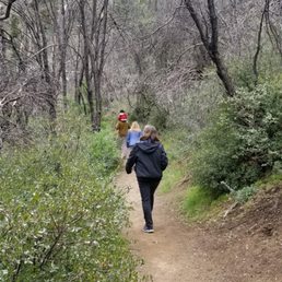
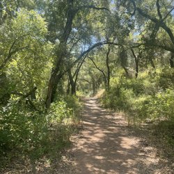
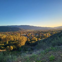
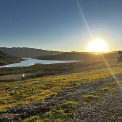
This trail has officially taken the #1 spot on my list of faves - seriously my all time fave trail EVER! Even though it's a very short trail - the scenery is just pure beauty on a whole other level! This trail is in the Los Padres National Forest near Ojai. The trailhead is inside the Rose Valley Campground. It's pretty short and doesn't have much incline - we did 1.5 miles total with only 220 feet of elevation gain. The trail is mostly soft dirt and is well maintained and obvious - but there are some rocky areas and you'll have to cross a couple of little streams - but it's totally easy and doable. The area is still recovering from the massive Thomas Fire a few years ago - the vegetation and skeletons of burned trees made for an eerily beautiful hike! It was almost alien looking - red, pink, and yellow spindly bushes covering the ground, surrounding the twisted, charred remains of tall tree trunks, all amongst healthy green new growth that seems to be flourishing! Then there's the waterfall - well actually there are two really gorgeous falls along this part of the trail! There's one smaller one along the path, maybe about 2/3rds of the way in - it's shorter but big enough to be worth clamoring down the steep path and grabbing some pics! It's got a little tiering going on and empties into a large pool, so it looks really cool! The main falls are like something out of a Victorian gothic garden of sorts! Absolutely breathtaking- my fave waterfall EVER!! It's about 100 feet tall, the rock is all covered in vibrant green moss, and there are all these fern-fringed little caverns and holes - just amazing! The waterfall isn't a huge flow, but more like a wispy thin stream gliding down the moss with lots of outlets dripping out of the ferns all around. Rock scrambling is required to get up close and for any decent pics - but it's very manageable- be aware you'll get a little wet, mostly on your shoes but not too bad. We didn't need any poles but definitely recommend good hiking shoes. Apparently there's a third, even taller part - the "upper falls" that is around 200 feet tall - I didn't know until afterwards. But the route up is very strenuous, unmarked, unmaintained, and supposedly dangerous with a history of people falling and even a tragic death from a fall back in 2015! Shame - the pics of it look even more incredible, if that's possible lol! On the way out of the parking area, we noticed a lovely little lake that had tons of birds and waterfowl!! We stopped and walked around and grabbed some pics of course - just gorgeous!! The road around it is in pretty bad shape - but the walk around it was only 1/2 mile so it's small. The road into the forest and to the trail is well maintained- but you do go quite a bit far into the National Forest and there's no cell signal so be prepared. We parked outside of the gate to the campgrounds along the side of the road (free) - online it says you can pay $10 for day-use parking inside the campground. But there's a huge puddle you'll have to drive over and we didn't want to take a chance on it lol. There are several bathrooms but they were absolutely disgusting- all of them- when we were there - so bad we wouldn't even go in! There were more bathrooms near the lake outside the campgrounds that were in better shape and usable.


Decided on a whim to do a hike and ended up checking out this trail. It's not too far from downtown Ojai. I would probably say about a 40 min drive. There weren't too many cars going up, so there weren't a lot of people there. We practically had the trail to ourselves. The morning was cloudy, so it made for a pleasant hike. Along the trail, there is like a mini waterfall and body of water. Was able to take a couple pics with no one there. We continued on, and there was the main fall at the end of the trail. It was really nice to enjoy the fall by ourselves for about 20 minutes. By the way, we parked right outside of the campground gates and just walked through. When walking in, stay on the left and there is a sign that says trail. A little after that, veer to the left and there should be an opening before one of the camping spaces. That is the start of the trail. This was a relatively easy hike and is about a mile round trip. There were some areas that you cross over logs and streams of water, but not too bad. I would totally come back!

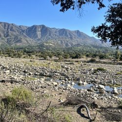
If it weren't for the distance, I'd be here once a week! My type of hike = Little work with a big payoff. 0.8 miles out and back flat, well-maintained trail (only 150 foot elevation gain) in exchange for a 300 foot waterfall. For California standards, that's pretty DAMN tall (pun intended)! Note: Access to the lower falls is easy and most popular with a 100 foot cascade; the upper tier is for advanced hikers with no marked trail. Rose Valley Falls is particularly gorgeous in the winter and spring when it flows the most and has spring flowers along the trail's creek. Since it is tucked in the forested nook of a mountain, there is a fair amount of ferns and moss growing on the black rock. I once came here and it was filled with little toads EVERYWHERE which was a spectacular, fun addition. Get Here: Rose Valley Falls is easily found on Google Maps or with the GPS coordinates of 34.5261184,-119.1880306. Hidden deep within Los Padres National Forest via Route 33 inland, past the hip town of Ojai by about a 35 minute drive, continue until you reach Rose Valley Road, then simply follow the signs to the falls trailhead. The views along the road are quite worth the trip alone. There is also the Rose Valley Campground which is free and first-come, first-serve to campers.
This is a nice short hike in Ojai. There is a nice waterfall at the end and plenty of spots to enjoy the beauty of the outdoors. A good hike for families not much more than a mile round trip and very little incline. We went in February and it actually snowed a tiny bit. It seems to almost have its own little micro climate. Wonderful views driving to Rose Valley too. Tips: park outside the campground for free parking and remember to bring layers the weather can be cooler or warmer.


I wasn't looking for another overcrowded Bonita Falls experience. I did my homework this time and I learned that people start showing up by 8:30am. I arrived at 7am and I had the entire two-tier 300-foot waterfall all to myself. What a difference it makes. The hike is an easy 0.8 miles round trip. The trailhead starts at the Rose Valley Campground. The trailhead is a little hidden behind one of the campsites. The trail crosses Rose Creek a couple of times and continues up the canyon and ends at the base of lower (100 foot) Rose Valley Falls. There are a bunch of boulders at the base of the falls that you can climb over. Theres also a small cave at the foot of the falls. I've read that you can continue the climb to the upper falls but it can be a little dangerous. No Adventure Pass is required to park outside of the campground alongside the road but there is a day use fee of $10 if you park in the Rose Valley Campground. There's a bathroom located at the campground. This is definitely one to bring the entire family.


GORGEOUS easy hike. Good amount of shade, you can avoid getting your feet wet and never saw any living things (snakes, bugs, tadpoles, whatever). Really enjoyed our time there! Just a bit hard to find. Enter from the campground and chose the path on left side. Going right up a hill is apparently a MUCH longer/harder hike!

Short walk to the waterfall and very easy, anybody can do it, kids, pets, grandma and grandpa. A quick 10 min walk, the water is cold and so refreshing, the moss over the area looks soo green, the tress have grown back again after the fire and offer shade by the waterfall and stream. We didn't go up the top of the waterfall, there were big boulders, we did saw a trail, maybe next time. Someone told us there was a rattle snake in the area and to be careful The camp manager told us the adventure pass no longer can be use to park here so to park for day use is $10 as of June/2019


It's a great easy & quick hike to the waterfall. As other reviewers say, you can park your car in front of the campground entrance (if space is still available) to save $10 parking fee. Even we haven't had any rain recently, we got to see small waterfalls. If you love hiking and waterfalls, I highly recommend this place!

11 months ago
Love this hike! It's short and super easy! There are restrooms nearby. The only downside is that there is no reception so plan accordingly! read more


1 year ago
Mesmerizing waterfalls and very short hike! Hiking is very short .5 mile one way. You can see the fall from the trailhead. read more


8 months ago
This trail has officially taken the #1 spot on my list of faves - seriously my all time fave trail EVER! Even though it's a very short trail - the scenery is just pure beauty on a whole other level! This trail is in the Los Padres National Forest near Ojai. The trailhead is inside the Rose Valley Campground. It's pretty short and doesn't have much incline - we did 1.5 miles total with only 220 feet of elevation gain. The trail is mostly soft dirt and is well maintained and obvious - but there are some rocky areas and you'll have to cross a couple of little streams - but it's totally easy and doable. The area is still recovering from the massive Thomas Fire a few years ago - the vegetation and skeletons of burned trees made for an eerily beautiful hike! It was almost alien looking - red, pink, and yellow spindly bushes covering the ground, surrounding the twisted, charred remains of tall tree trunks, all amongst healthy green new growth that seems to be flourishing! Then there's the waterfall - well actually there are two really gorgeous falls along this part of the trail! There's one smaller one along the path, maybe about 2/3rds of the way in - it's shorter but big enough to be worth clamoring down the steep path and grabbing some pics! It's got a little tiering going on and empties into a large pool, so it looks really cool! The main falls are like something out of a Victorian gothic garden of sorts! Absolutely breathtaking- my fave waterfall EVER!! It's about 100 feet tall, the rock is all covered in vibrant green moss, and there are all these fern-fringed little caverns and holes - just amazing! The waterfall isn't a huge flow, but more like a wispy thin stream gliding down the moss with lots of outlets dripping out of the ferns all around. Rock scrambling is required to get up close and for any decent pics - but it's very manageable- be aware you'll get a little wet, mostly on your shoes but not too bad. We didn't need any poles but definitely recommend good hiking shoes. Apparently there's a third, even taller part - the "upper falls" that is around 200 feet tall - I didn't know until afterwards. But the route up is very strenuous, unmarked, unmaintained, and supposedly dangerous with a history of people falling and even a tragic death from a fall back in 2015! Shame - the pics of it look even more incredible, if that's possible lol! On the way out of the parking area, we noticed a lovely little lake that had tons of birds and waterfowl!! We stopped and walked around and grabbed some pics of course - just gorgeous!! The road around it is in pretty bad shape - but the walk around it was only 1/2 mile so it's small. The road into the forest and to the trail is well maintained- but you do go quite a bit far into the National Forest and there's no cell signal so be prepared. We parked outside of the gate to the campgrounds along the side of the road (free) - online it says you can pay $10 for day-use parking inside the campground. But there's a huge puddle you'll have to drive over and we didn't want to take a chance on it lol. There are several bathrooms but they were absolutely disgusting- all of them- when we were there - so bad we wouldn't even go in! There were more bathrooms near the lake outside the campgrounds that were in better shape and usable. read more


 - Hiking Near Me - Ojai, California")


2 years ago
Absolutely love this hike, it's the most gorgeous spot ever! Watch out for the one way roads going up, sometimes it takes 15 mins but it's well worth it! read more


Decided on a whim to do a hike and ended up checking out this trail. It's not too far from downtown Ojai. I would probably say about a 40 min drive. There weren't too many cars going up, so there weren't a lot of people there. We practically had the trail to ourselves. The morning was cloudy, so it made for a pleasant hike. Along the trail, there is like a mini waterfall and body of water. Was able to take a couple pics with no one there. We continued on, and there was the main fall at the end of the trail. It was really nice to enjoy the fall by ourselves for about 20 minutes. By the way, we parked right outside of the campground gates and just walked through. When walking in, stay on the left and there is a sign that says trail. A little after that, veer to the left and there should be an opening before one of the camping spaces. That is the start of the trail. This was a relatively easy hike and is about a mile round trip. There were some areas that you cross over logs and streams of water, but not too bad. I would totally come back! read more


If it weren't for the distance, I'd be here once a week! My type of hike = Little work with a big payoff. 0.8 miles out and back flat, well-maintained trail (only 150 foot elevation gain) in exchange for a 300 foot waterfall. For California standards, that's pretty DAMN tall (pun intended)! Note: Access to the lower falls is easy and most popular with a 100 foot cascade; the upper tier is for advanced hikers with no marked trail. Rose Valley Falls is particularly gorgeous in the winter and spring when it flows the most and has spring flowers along the trail's creek. Since it is tucked in the forested nook of a mountain, there is a fair amount of ferns and moss growing on the black rock. I once came here and it was filled with little toads EVERYWHERE which was a spectacular, fun addition. Get Here: Rose Valley Falls is easily found on Google Maps or with the GPS coordinates of 34.5261184,-119.1880306. Hidden deep within Los Padres National Forest via Route 33 inland, past the hip town of Ojai by about a 35 minute drive, continue until you reach Rose Valley Road, then simply follow the signs to the falls trailhead. The views along the road are quite worth the trip alone. There is also the Rose Valley Campground which is free and first-come, first-serve to campers. read more

 - Hiking Near Me - Ojai, California")


1 year ago
This is a nice short hike in Ojai. There is a nice waterfall at the end and plenty of spots to enjoy the beauty of the outdoors. A good hike for families not much more than a mile round trip and very little incline. We went in February and it actually snowed a tiny bit. It seems to almost have its own little micro climate. Wonderful views driving to Rose Valley too. Tips: park outside the campground for free parking and remember to bring layers the weather can be cooler or warmer. read more


2 years ago
Short easy hike (0.8 mi) to the falls. Trailhead next to site 3. Restrooms available prior to the trailhead. read more


I wasn't looking for another overcrowded Bonita Falls experience. I did my homework this time and I learned that people start showing up by 8:30am. I arrived at 7am and I had the entire two-tier 300-foot waterfall all to myself. What a difference it makes. The hike is an easy 0.8 miles round trip. The trailhead starts at the Rose Valley Campground. The trailhead is a little hidden behind one of the campsites. The trail crosses Rose Creek a couple of times and continues up the canyon and ends at the base of lower (100 foot) Rose Valley Falls. There are a bunch of boulders at the base of the falls that you can climb over. Theres also a small cave at the foot of the falls. I've read that you can continue the climb to the upper falls but it can be a little dangerous. No Adventure Pass is required to park outside of the campground alongside the road but there is a day use fee of $10 if you park in the Rose Valley Campground. There's a bathroom located at the campground. This is definitely one to bring the entire family. read more


2 years ago
My favorite waters falls in Ventura County. Been going here for 10+ years and today was my favorite time. Water is pouring, reservoirs are full, and weather is perfect. read more

GORGEOUS easy hike. Good amount of shade, you can avoid getting your feet wet and never saw any living things (snakes, bugs, tadpoles, whatever). Really enjoyed our time there! Just a bit hard to find. Enter from the campground and chose the path on left side. Going right up a hill is apparently a MUCH longer/harder hike! read more

4 years ago
Short walk to the waterfall and very easy, anybody can do it, kids, pets, grandma and grandpa. A quick 10 min walk, the water is cold and so refreshing, the moss over the area looks soo green, the tress have grown back again after the fire and offer shade by the waterfall and stream. We didn't go up the top of the waterfall, there were big boulders, we did saw a trail, maybe next time. Someone told us there was a rattle snake in the area and to be careful The camp manager told us the adventure pass no longer can be use to park here so to park for day use is $10 as of June/2019 read more


7 years ago
Definitely a must hike when in the Ojai area it's a short hike with beautiful scenery and falls. You can still see some char from the fires but it's growing and looks beautiful. read more


5 years ago
It's a great easy & quick hike to the waterfall. As other reviewers say, you can park your car in front of the campground entrance (if space is still available) to save $10 parking fee. Even we haven't had any rain recently, we got to see small waterfalls. If you love hiking and waterfalls, I highly recommend this place! read more


About a 40 minute drive from downtown. Note the winding roads. Short hike with a smaller waterfall + the main attraction shortly after. Very doable for families with children. Dog friendly. However, note that the rocks can be slippery to climb on if you're trying to get a photo up close. I know some months have more waterfall than others. Is it worth the drive out? In my opinion, YES. The drive was beautiful weaving through mountains. The water falling from the moss! read more

6 years ago
NEW FAVORITE HIKE! I currently live in Los Angeles, but the drive was reaaaally worth it. Not only did I get to enjoy TWO waterfalls.. one of them, my best friend and I had completely to ourselves. The first, more easily accessible water fall, also has a little cave you can crawl into.. for those that aren't afraid of getting a little dirty. It wasn't easy getting to the second waterfall, but we rock climbed our way up (and down)! No better place to stage your own photo shoot ;) The struggle was coming back down the steep hills. The best part was that it wasn't even crowded. Make sure you bring lots of drinking water, secure hiking boots and a bathing suit! :) read more


Beautiful Falls. Not a 5 as it's just too short of a hike for me..20 min round trip. Took about 45 minutes to drive from town. There is lots of road work on the highway. Real pretty hike. Walk to the end of the campground, straight to end to begin hike. You cross over streams and there still is some wildflowers around. Not a lot of shade. The area has nicely recovered since the fire. It is amazing to see all the ferns and greenery by the falls. That is what makes this such a special spot. There also are bathrooms by the parking area. There are no fees for day use. Also no pass is needed. Enjoy! read more


This is a really small place with access to port-o-potties and bathrooms inside. We saw that people can camp here as well. If you're looking for an easy waterfall hike, this is it. It's not really labeled with clear signs so make sure that you follow the right path. It's a little sad that you can see what was affected by the fire. My fiancé and I decided to be courageous and follow a path that was closed off but it really leaves you uphill to nothing. read more

5 years ago
Wow! It is a beautiful and an easy hike. The short hike starts at the Rose valley campground. Went on 1/17/21 and there was water. read more


6 years ago
A nice short hike to the waterfall. I came on Dec 15th 2020, not much water but still very pretty. Trail is easy to find...go through the gate where the rose valley campground sign and walk through the campground on the left until you find camp spot number 5 and you'll see behind it, a white sign that says "rose valley falls" and that's the beginning of the hike. Highly recommended but please don't leave trash or tag this place and ruin it for everybody...leave nothing behind! read more


I had a great time hiking to the falls. The hike was very short but that's what I like. I went on November 23rd and it was not busy and when I did pass people they were wearing their masks like me so I felt safe. There isn't a ton of water at the Falls but it was still relaxing to sit and listen to the water. I recommend visiting if you are in the area! The photos beneath I took read more


6 years ago
The hike is a mere .45 of a mile each way so it's not that bad for those with children. There was a lot of people on the trail and at the falls. Don't plan to stay there all days as there is minimal space to hang out around the falls. It's a great place to get some cool pictures for kids. Although the hike is not long, there are a few obstacles to navigate and a couple of stream crossings. Nothing crazy but your shoes will get wet. read more


A simply beautiful waterfall that's about a mile hiking into the woods a bit in the Los Padres National Forest Campgrounds. The drive to get through can be a bit long, but the gorgeous bodies of water and winding roads more than make up for the distance. When you turn into the Campgrounds, park outside of the entrance (since there is no designated parking lot inside the campgrounds for visitors). Use the outside lavatory house if needed. When you walk in, look for the signs attached to the poles for directions on how to get to the waterfall. You'll see little streams and rivers, boulders and rocks and winding pathways to get there, but the most gorgeous part (for me) definitely has to be the overhanging trees that create such a beautiful canopy over the forest. When you reach the end, the breeze is so cool and the mist from the waterfall is refreshing to the surrounding area as people stop to take pictures of the falls, or just sit on the many boulders and enjoy the crispy clear air and beautiful scene. We came in mid-March and the timing was just great. No clouds in the sky and the weather was slightly warm so the waterfall mist is definitely a nice treat. Just a note... Expectation vs Reality: There's always a hyped up excitement whenever you visit a new place and you're excited to see for yourself the beauty of nature. Just be advised that this isn't some gorgeous free flowing huge waterfall across big boulders of rock. It's a small hidden waterfall hidden inside a forest campground. Appreciate beauty where it lies and how it got there. read more


6 years ago
This was our (my husband's and my) first trip to Ojai, especially here at the Rose Valley Waterfalls. When we got here, we didn't know we had to pay $10 to park for the day until we were done and returned to the car (as we found a warning to pay "ticket" on our windshield). The instruction of where the trail was not very clear, but it was really a nice, smooth, and short hiking trail. Little did we know, we arrived at the waterfall area. It was beautiful, serene, tranquil, and soothing. We won't mind coming back here again in the future to explore further. read more


9 years ago
Awesome hike- beautiful and easy, the water at the falls is so crisp and clean. Gorgeous experience and just rugged enough to know you are hiking not just strolling. Was not crowded so we took our time enjoying the place. Highly recommend. read more


10 years ago
Great hike today at Rose Valley Falls. It was a short hike to the falls (.8 miles), but if you're looking for a longer adventure, you can take a path up the mountain side to get to the upper falls. Hiking boots/shoes recommended. Going up the mountain is pretty steep, lots of loose rocks and gravel. I found myself holding on to roots and branches to catch my next step. Once you make it to the top of the lower fall, you'll find the stream that leads down the fall. Follow the stream the opposite direction and you'll find a nice water hall to take a dip in. Follow the trail back towards the fall and take the path to the left. This again will take you through a tough hike up lose gravel/sharp slate and alongside the mountain. To get back down, you can carefully slide your way down another open path through some orchards before you catch the main trail back. The lower falls had a beautiful trickle of water coming down. Behind the fall is a mini-cave you can stand in to take pictures. Everything is picturesque at the falls. Well worth the long drive in. Because we got lost following directions on Google, here's the best/easy directions: 101 to the 33hwy to Ojai. Make a left on Maricopa Hwy (you'll see the Vons Shopping Center). Go down Maricopa Hwy for about 12 miles, you'll start seeing signs for Rose Valley Falls. Follow the road into the park (another 2 miles in) and make a right on Rose Valley Lake Road. Follow the road until it dead ends to the trail head. Tips: Pick up a $5 adventure pass at a sporting store who sells it. We got ours at REI in Oxnard. Enjoy! read more


12 years ago
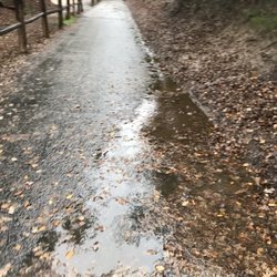
THE HIKE: Easy as they get. Distance - Just shy of 1 mile round-trip Park outside the gates of the small campground, then make your way inside following the main road. There is a sign at the start of the trail. The trail is well maintained and more-or-less a straight shot along the stream to the falls. You'll be on a path above the stream. Sliding down the slope to explore the creek and pools is possible, but maybe not for the younger ones. There's plenty of water play at the falls anyhow. There are two water crossings - which amount to stepping over puddles, they're not that big. Maybe after a rain they'd be a problem. The trail is reasonably wide and gradually sloped hiking in, but not bad - my wife carried our two-year-old the whole way there. The hike out is easy as it is mostly downhill. The trail has very good shade throughout. Not much in the way of vistas or scenery other than the trail itself. You'll catch peek-a-boo looks at the surrounding mountain range every now and then. A person in town warned us about rattlesnakes. We didn't see any, but please be aware of them anyway. Remind children to stay on the trail and don't reach into holes or anywhere you can't see (rocks, crevices, logs, etc.) MOSQUITOS though. Bring repellent or end up feeding them like I did. Another reason to stay on the trail: Poison ivy. There was some but not hanging out into the trail and easily avoidable. If you bring children, have a change of clothes for the walk back unless you want to manage damp and muddy kids all the way to your car. You certainly don't want that for the ride home. The falls consist of two tiers and two pools. The upper pool looked deeper at the time and was about the size of a hot tub. The lower pool was small and shallow, more like a place to splash around in. The water finds its way a good 10 feet down through rocks and fallen logs to form the stream you followed to the falls. I don't recommend playing on that lower section beneath the two pools, it looked sketchy at best. There is a cave that loops in and out of the rock that kids will enjoy. The exit (or entrance, whichever way you go) is through the falls, like a carwash. Some adventurous adults might enjoy it too! At the end of the trail is a good (dry) space to spread out, eat, and keep your belongings. There was as a crowd when we got there. It is a well-known and easily accessible spot so expect to share! Ryan ohlittletree.com - Outdoor Blog for Parents read more

Great little getaway from town. A very manageable hike to the first falls. There we found a trickle of water coming down the falls. It was actually quite pleasant. I decided to climb up the left hand side of the falls only to discover the much larger falls. I would guess that the actual falls are behind the first set of falls you come to. The bigger falls were dry but still at nice view. The climb up the left hand side was steep and challenging so I would only recommend that route to folks that are able-bodied and get something out of the rush of some scrambling. There is a path to the right side of the first falls but I'm not sure if they are more or less challenging as the left side. Overall I really enjoyed he hike. There was something for everyone. read more


15 years ago
11 years ago
13 years ago
Page 1 of 2
More info about Rose Valley Falls
Chief Peak Rd
Los Padres National Forest
Ojai, CA 93023
Directions
Hours
Outdoor Amenities
Ask the Community - Rose Valley Falls
Anyway to park w/o paying?
Review Highlights - Rose Valley Falls


Why does Yelp recommend reviews?
3 reviews that are not currently recommended
The reviews below are not factored into the business's overall star rating.
13 years ago
3 years ago
10 years ago
Rose Valley Falls - hiking - Updated June 2026
Best of Ojai
People found Rose Valley Falls by searching for…
Things to Do in Ojai, California
Campgrounds in Ojai, California
Hiking Trails With Waterfalls in Ojai, California
Star Gazing in Ojai, California
Rock Climbing in Ojai, California
Places to Take Pictures in Ojai, California
Attractions in Ojai, California
Dog Friendly Hiking Trails in Ojai, California
Off Road Trails in Ojai, California
Natural Hot Springs in Ojai, California
Fishing Spots in Ojai, California
Swimming Lakes in Ojai, California
Waterfalls and Swimming Holes in Ojai, California
Tent Camping in Ojai, California
Camping Sites in Ojai, California
Beautiful Views in Ojai, California
Easy Hikes in Ojai, California
Scenic Spots in Ojai, California
Botanical Gardens in Ojai, California
Trending Searches in Ojai, CA
Black Owned Nail Salons near Rose Valley Falls
Boat Rental near Rose Valley Falls
Cliff Jumping near Rose Valley Falls
Day Trips near Rose Valley Falls
Dog Friendly Trails near Rose Valley Falls
Fireworks near Rose Valley Falls
Fishing Spots near Rose Valley Falls
Jet Ski Rental near Rose Valley Falls
Kayak Rental near Rose Valley Falls
Lakes & Ponds near Rose Valley Falls
Outdoor Activities near Rose Valley Falls
Places To Walk Around near Rose Valley Falls
Public Pools near Rose Valley Falls
Public Shower near Rose Valley Falls
River Swimming near Rose Valley Falls
Rock Quarry near Rose Valley Falls
Scenic Night View near Rose Valley Falls
Scenic Overlook near Rose Valley Falls
Secluded Spots near Rose Valley Falls
Soccer Store near Rose Valley Falls
Splash Pad near Rose Valley Falls
Strawberry Picking near Rose Valley Falls
Sunrise View near Rose Valley Falls
Swimming Holes near Rose Valley Falls
Swimming Lakes near Rose Valley Falls
Watch Sunset near Rose Valley Falls
Browse Nearby
Browse Brands
Related Searches in Ojai, CA
Affordable Kayak Rental Services in Ojai, California
Best Fishing Locations and Guides in Ojai, California
Best Places for Horseback Riding in Ojai, California
Best Waterfalls and Swimming Holes in Ojai, California
Check Out Off Road Trails in Ojai, California
Discover Dog Friendly Trails to Explore in Ojai, California
Discover Kid Friendly Hiking Trails in Ojai, California
Discover Scenic Waterfall Spots in Ojai, California
Discover a Hiking Trail in Ojai, California
Discover the Best Night Hike Trails in Ojai, California
Discover the Best Running Track in Ojai, California
Dog-Friendly Hikes With Dogs in Ojai, California
Enjoy Camping Adventures Around Ojai, California
Enjoy Exciting Mountain Biking Adventures in Ojai, California
Enjoy Kayaking Adventures in Ojai, California
Enjoy Tent Camping Spots Around Ojai, California
Enjoy a Beautiful Waterfall Hike in Ojai, California
Enjoy a Peaceful Nature Walk in Ojai, California
Enjoy the Best Picnic Spots and Ideas in Ojai, California
Enjoy the Best Walking Path in Ojai, California
Enjoy the Best Walking Trails in Ojai, California
Exciting Cliff Jumping Spots in Ojai, California
Explore Beautiful Parks and Green Spaces in Ojai, California
Explore Easy Hikes Perfect for All in Ojai, California
Explore Fun Activities to Do in Ojai, California
Explore Popular Campgrounds Near Ojai, California
Explore the Best Beach Spots in Ojai, California
Explore the Best Swimming Holes Around Ojai, California
Explore the Best Trail Options in Ojai, California
Family Friendly Hiking With Kids in Ojai, California
Find Beautiful Views in Ojai, California
Find Popular Ziplining Spots Around Ojai, California
Find the Best Parks for Picnics in Ojai, California
Find the Best Scenic View Locations in Ojai, California
Great Places to Walk in Ojai, California
Hiking Trails With Waterfalls in Ojai, California
Plan a Scenic Drive Route Near Ojai, California
Play at a Splash Pad Park in Ojai, California
Popular Outdoor Activities to Try in Ojai, California
Popular Picnic Spots to Visit in Ojai, California
Safe River Swimming Areas in Ojai, California
Safe and Fun Parks for Kids in Ojai, California
Top Climbing Spots and Gyms in Ojai, California
Top Paddleboarding Activities in Ojai, California
Top Places for Snorkeling in Ojai, California
Top Running Trails to Explore in Ojai, California
Top Swimming Lakes to Enjoy in Ojai, California
Top Swimming Spots and Pools in Ojai, California