Ojai Valley Trail Photos


You might also consider
More like Ojai Valley Trail
Recommended Reviews - Ojai Valley Trail
Start your review...

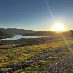
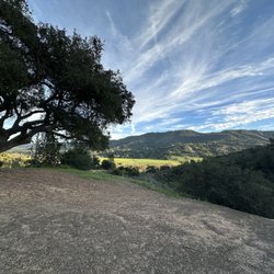
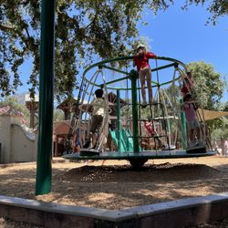
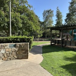
Reviews With Photos

Come on Mikey, let's go hiking, they said. It will be fun, they said. First of all, I hate walking. Walking is stupid. Walking is why I own a car, and why I don't mind paying exorbitant fees for registration and $5 a gallon for gas. Walking is for idiots. Hiking is even worse than walking. Hiking is just some kind of pretentious walking. It's diabolical, really. I'm pretty sure that's what Hell is, just aimless hiking forever and ever. Hiking pisses me off. So they bring me here, to the Ojai Valley Trail. I'm like, oh my god, not this damn trail again. I immediately recognized where we were. I got hoodwinked into doing this damn trail a couple years ago. Last time it was just my wife and I. Soon as I saw the trail I was like, oh hell no. I threw a complete fit. My wife knew I would probably have a melt down so she had a backup plan: electric bikes. That time we rented electric bikes at the BoKU Superfoods Store and had a really wonderful day cruising up and down this trail. It's a beautiful trail if you aren't forced to actually walk it. That's what happened to me today. I was forced to walk it. We came here with family visiting from Northern California. Everybody was all into the whole hiking thing. There was no way I was going to get anywhere throwing a tantrum. I had to suck it up and walk. What's this trail like? I'll tell you. You walk and walk and walk some more. Then you keep walking. It's like you are part of the Lewis and Clark expedition. To me it felt like the Bataan Death March. Oh my god does this damn trail ever end? No, it doesn't. I think you can walk all the way to Canada on this freaking trail. The trail is completely different when you are walking, compared to riding. When you are riding the sun is shining, the birds are singing, and when you stop along the trail, squirrels will come right up and offer to share their nuts with you. When you walk the trail there is no sun. The sky is dark and hangs low over your head. The only birds you hear are the crows. And those crows are all laughing at you because even crows know how stupid hiking is. You'll never see a crow hike anywhere. No siree. Would I go back to the Ojai Valley Trail? If we can rent eBikes, hell yes. But to hike it? Oh hell no. Not willingly, anyway. Still, I rate this trail a solid five stars because I understand walking and hiking is not an issue for most people. Seems weird to me, but some people actually enjoy walking and hiking. It takes all kinds, I guess. Oh, and objectively speaking, you are walking through one of the most beautiful areas in the county. So, yeah, Five Stars! Mikey C says: I don't know how much longer I can keep complaining.

1 year ago
Ojai Valley Trail-Ventura Trail A bucket list to do since first learning of it. It was so much fun if not humbling. I am an older back of the pack athlete but felt confident going in since elevation isn't too high(approx 800 ft). We set off on our bikes two miles west of Ojai and it was all fun and games going to Ventura as we rode through beautiful oak canopies, flew up and mostly down past meadows of mustard flowers and CA poppies; petroleum fields; beautiful home gardens; steel framed wooden bridges; and sections of Highway 33. A wonderfully cloudy day made it so much more enjoyable. We got off at Main Street only to realize I had punctured my tire so we walked our bikes over to the pedestrian promenade in Downtown Ventura to look for a bite to eat and locate a repair shop. Once we enjoyed our wonderful breakfast at Immigrant Son Cafe we walked our bikes with the idea of going to Bicycle Hub to unexpectedly findi Shigy's Bike who replaced my destroyed tire in 5min($54)! We were back in action now, fed, caffeinated and sporting a brand new front tire. We rode past amazing murals to head back toward Ojai. That coffee and carb loading prepped me well but it couldn't spare me the effort it took me to go up those small inclines and the slope of the Ojai Valley. I raced against my fitness and the clock as I tried to get us to Oak Creek Winery before last pour(4:30), but my body couldn't pull off this miracle plus I later learned there isn't bike-friendly access to this winery from the trail as I originally thought( hint hint). A must try for biking enthusiasts of all levels (I saw many e-bikes on trail even though signage states no motorized bikes should be on it). read more


This is a very nice trail for biking back and forth between Ventura and Ojai. There are interesting bridges, most of the path is smooth, and not very steep. There are portions for stopping, hiking, enjoying nature. It's easy to follow and a good day trip. We've been many times on both regular bikes and e-bikes. read more


Come on Mikey, let's go hiking, they said. It will be fun, they said. First of all, I hate walking. Walking is stupid. Walking is why I own a car, and why I don't mind paying exorbitant fees for registration and $5 a gallon for gas. Walking is for idiots. Hiking is even worse than walking. Hiking is just some kind of pretentious walking. It's diabolical, really. I'm pretty sure that's what Hell is, just aimless hiking forever and ever. Hiking pisses me off. So they bring me here, to the Ojai Valley Trail. I'm like, oh my god, not this damn trail again. I immediately recognized where we were. I got hoodwinked into doing this damn trail a couple years ago. Last time it was just my wife and I. Soon as I saw the trail I was like, oh hell no. I threw a complete fit. My wife knew I would probably have a melt down so she had a backup plan: electric bikes. That time we rented electric bikes at the BoKU Superfoods Store and had a really wonderful day cruising up and down this trail. It's a beautiful trail if you aren't forced to actually walk it. That's what happened to me today. I was forced to walk it. We came here with family visiting from Northern California. Everybody was all into the whole hiking thing. There was no way I was going to get anywhere throwing a tantrum. I had to suck it up and walk. What's this trail like? I'll tell you. You walk and walk and walk some more. Then you keep walking. It's like you are part of the Lewis and Clark expedition. To me it felt like the Bataan Death March. Oh my god does this damn trail ever end? No, it doesn't. I think you can walk all the way to Canada on this freaking trail. The trail is completely different when you are walking, compared to riding. When you are riding the sun is shining, the birds are singing, and when you stop along the trail, squirrels will come right up and offer to share their nuts with you. When you walk the trail there is no sun. The sky is dark and hangs low over your head. The only birds you hear are the crows. And those crows are all laughing at you because even crows know how stupid hiking is. You'll never see a crow hike anywhere. No siree. Would I go back to the Ojai Valley Trail? If we can rent eBikes, hell yes. But to hike it? Oh hell no. Not willingly, anyway. Still, I rate this trail a solid five stars because I understand walking and hiking is not an issue for most people. Seems weird to me, but some people actually enjoy walking and hiking. It takes all kinds, I guess. Oh, and objectively speaking, you are walking through one of the most beautiful areas in the county. So, yeah, Five Stars! Mikey C says: I don't know how much longer I can keep complaining. read more


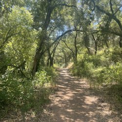
Hiking--or maybe more appropriately, walking--the Ojai Valley Trail was a lovely pastime on a recent visit to Ojai with friends. We started on the section of trail behind Cafe Boku and walked all the way to the end at Soule Park Golf Course. It was a very pleasant 1.5 mile stroll on flat surfaces, with ample shade. Many birds and squirrels to be seen. The trail is a nice way to experience a slice of the Ojai valley, meandering through people's back yards, Libbey Park, and grasslands. Lots of other walkers and dogs along the way (keep 'em on leash, people), and plenty of places to turn off for a cup of coffee, glass of wine, or a beer. It looks like the trail carries on all the way to Seaside Wilderness Park in Ventura. That would be a great ~15 mile hike for a longer day of walking. For us, the small portion we ambled was just right. A recommended addition to your relaxing time in Ojai! read more

3 years ago
More info about Ojai Valley Trail
Ask the Community - Ojai Valley Trail
You might also consider


Ojai Valley Trail - hiking - Updated July 2026
Best of Ojai
People found Ojai Valley Trail by searching for…
Trending Searches in Ojai, CA
Browse Articles
Browse Nearby
BEST of Ojai, California Things to Do near Ojai Valley Trail
BEST of Ojai, California Coffee near Ojai Valley Trail
BEST of Ojai, California Restaurants near Ojai Valley Trail
BEST of Ojai, California Walking Trails near Ojai Valley Trail
BEST of Ojai, California Parks near Ojai Valley Trail
BEST of Ojai, California Breakfast near Ojai Valley Trail
BEST of Ojai, California Hot Springs near Ojai Valley Trail
Browse Brands
Related Searches in Ojai, CA
Affordable Kayak Rental Services in Ojai, California
Best Fishing Locations and Guides in Ojai, California
Best Places for Horseback Riding in Ojai, California
Best Waterfalls and Swimming Holes in Ojai, California
Check Out Off Road Trails in Ojai, California
Discover Dog Friendly Trails to Explore in Ojai, California
Discover Kid Friendly Hiking Trails in Ojai, California
Discover Scenic Waterfall Spots in Ojai, California
Discover a Hiking Trail in Ojai, California
Discover the Best Night Hike Trails in Ojai, California
Discover the Best Running Track in Ojai, California
Dog-Friendly Hikes With Dogs in Ojai, California
Enjoy Camping Adventures Around Ojai, California
Enjoy Exciting Mountain Biking Adventures in Ojai, California
Enjoy Kayaking Adventures in Ojai, California
Enjoy Tent Camping Spots Around Ojai, California
Enjoy a Beautiful Waterfall Hike in Ojai, California
Enjoy a Peaceful Nature Walk in Ojai, California
Enjoy the Best Picnic Spots and Ideas in Ojai, California
Enjoy the Best Walking Path in Ojai, California
Enjoy the Best Walking Trails in Ojai, California
Exciting Cliff Jumping Spots in Ojai, California
Explore Beautiful Parks and Green Spaces in Ojai, California
Explore Easy Hikes Perfect for All in Ojai, California
Explore Fun Activities to Do in Ojai, California
Explore Popular Campgrounds Near Ojai, California
Explore the Best Beach Spots in Ojai, California
Explore the Best Swimming Holes Around Ojai, California
Explore the Best Trail Options in Ojai, California
Family Friendly Hiking With Kids in Ojai, California
Find Beautiful Views in Ojai, California
Find Popular Ziplining Spots Around Ojai, California
Find the Best Parks for Picnics in Ojai, California
Find the Best Scenic View Locations in Ojai, California
Great Places to Walk in Ojai, California
Hiking Trails With Waterfalls in Ojai, California
Plan a Scenic Drive Route Near Ojai, California
Play at a Splash Pad Park in Ojai, California
Popular Outdoor Activities to Try in Ojai, California
Popular Picnic Spots to Visit in Ojai, California
Safe River Swimming Areas in Ojai, California
Safe and Fun Parks for Kids in Ojai, California
Top Climbing Spots and Gyms in Ojai, California
Top Paddleboarding Activities in Ojai, California
Top Places for Snorkeling in Ojai, California
Top Running Trails to Explore in Ojai, California
Top Swimming Lakes to Enjoy in Ojai, California
Top Swimming Spots and Pools in Ojai, California
People who viewed Ojai Valley Trail also viewed
Ojai Valley Land Conservancy
7 reviews
Rose Valley Falls
56 reviews
Cozy Dell Trail
8 reviews
Sisar Canyon
2 reviews
Nordhoff Ridge Road
4 reviews
Lake Casitas Hiking Trail
1 review
Piedra Blanca Formations
4 reviews
Santa Paula Canyon Falls
17 reviews
Wheeler Gorge Nature Trail
1 review
Channel Islands National Park
115 reviews