Ojai Meadows Preserve Trail Photos


You might also consider
More like Ojai Meadows Preserve Trail
Recommended Reviews - Ojai Meadows Preserve Trail
Start your review...

Reviews With Photos

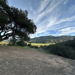
The Ojai Meadows is a very nice place to walk. Dogs are welcome on leashes, and most people do a good job of picking up after them, too. The property trails are well maintained by the volunteers. Benches are scattered along the trails and give great views of the pond and mountains. Close to all points in the Ojai Valley with adequate parking.

Delightful walk for a quick getaway from the world. I took my picnic lunch here and saw bunnies running in the meadow, blue belly, lizard, basking in the sun, ducks, floating in the pond, and quiet. I even saw a tiny little frog hopping along the path. Surprises everywhere. I turned in a very leisurely are preserved with. Wetlands everywhere and views all around. A great place to walk your dog or just have some serenity in your day.

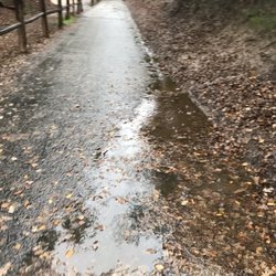
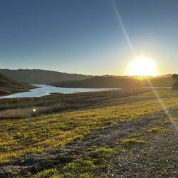
Lovely, easy trail in the main, busier area of Ojai - perfect for an evening sunset stroll! It's part of the Ojai Valley Land Conservancy and is about a mile long- but there are some trail offshoots so you can make it longer - we ended up doing about 1.2 miles. Very easy and flat - tiny, unnoticeable elevation gains - well maintained and marked trails. It's also got a lot of shade and seating areas. There are several pond areas teeming with birds and frogs - it's absolutely fantastic in the evenings - tons of ribbits and chirping filling the air! A great little spot for some bridging - I saw red winged black birds, great egrets, and a great blue heron! There were some rain clouds hovering over the mountain tops off in the distance that made for quite a dramatic backdrop. This trial is pretty busy and felt crowded at times. It's also next to a sort of busy road so you can't get away from the traffic noise - but it's not too bad. There were a lot of loud kids on bikes and an occasional sketchy person - but nothing scary. So this is the reason for the 4 stars. Parking is street parking and is ample. I didn't see any bathrooms but the trails are well kept and had plenty of trash cans, etc. Was a very clean trail too. A good trail to end on for the day!

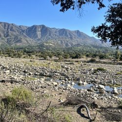
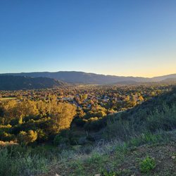
One of my favorite trails in Ojai, with views, more views, a pond, birdies in season, and a variety of loop trails in a quiet setting. Enjoy a sit on one of the benches, or bring a leashed dog to enjoy a stroll. The all-weather trails are wide and flat, while one trail leads off for a long jaunt with more elevation. Parking is available all along the main road.

This is a nice little getaway spot that you can walk around and enjoy the nature and outdoors. It's not too far from the downtown of Ojai. Parking is a little tricky. There's striped lines in front of the meadows on the main street that's designated for parking. It looks like you can't park there but you can. The park itself is wonderful. Beautiful walk in the park as they say. We even saw a little gopher. The further you go inside you are greeted with beautiful flowers and wildlife. The park itself looks like a loop so you end up back where you park. Definitely a nice bit of outdoor life. read more


Such a great little walk. I REALLY enjoy coming here when I want a scenic walk that feels good. I usually grab a pastry and tea from Beacon on my way, and then take the pup for this nice stroll. It's not long at all but really pretty grass, meadow, creek, eucalyptus, etc. A great place for birding -I have seen baby owls in the trees, amongst so many hawks and sub jays, etc. Do yourself a favor and walk this pretty little trail ...your should will thank you! read more
The Ojai Meadows is a very nice place to walk. Dogs are welcome on leashes, and most people do a good job of picking up after them, too. The property trails are well maintained by the volunteers. Benches are scattered along the trails and give great views of the pond and mountains. Close to all points in the Ojai Valley with adequate parking. read more
Delightful walk for a quick getaway from the world. I took my picnic lunch here and saw bunnies running in the meadow, blue belly, lizard, basking in the sun, ducks, floating in the pond, and quiet. I even saw a tiny little frog hopping along the path. Surprises everywhere. I turned in a very leisurely are preserved with. Wetlands everywhere and views all around. A great place to walk your dog or just have some serenity in your day. read more


Lovely, easy trail in the main, busier area of Ojai - perfect for an evening sunset stroll! It's part of the Ojai Valley Land Conservancy and is about a mile long- but there are some trail offshoots so you can make it longer - we ended up doing about 1.2 miles. Very easy and flat - tiny, unnoticeable elevation gains - well maintained and marked trails. It's also got a lot of shade and seating areas. There are several pond areas teeming with birds and frogs - it's absolutely fantastic in the evenings - tons of ribbits and chirping filling the air! A great little spot for some bridging - I saw red winged black birds, great egrets, and a great blue heron! There were some rain clouds hovering over the mountain tops off in the distance that made for quite a dramatic backdrop. This trial is pretty busy and felt crowded at times. It's also next to a sort of busy road so you can't get away from the traffic noise - but it's not too bad. There were a lot of loud kids on bikes and an occasional sketchy person - but nothing scary. So this is the reason for the 4 stars. Parking is street parking and is ample. I didn't see any bathrooms but the trails are well kept and had plenty of trash cans, etc. Was a very clean trail too. A good trail to end on for the day! read more


One of my favorite trails in Ojai, with views, more views, a pond, birdies in season, and a variety of loop trails in a quiet setting. Enjoy a sit on one of the benches, or bring a leashed dog to enjoy a stroll. The all-weather trails are wide and flat, while one trail leads off for a long jaunt with more elevation. Parking is available all along the main road. read more

2 years ago
5 years ago
I visited the Ojai Meadows Preserve Trail yesterday evening when it's wasn't so hot outside. It's a lovely place for a stroll. Some nice shaded areas and walking paths. It's an easy walk. I met a lot of friendly locals who gave me insights on where to spot certain birds. I will definitely be back here again some day soon. read more


3 years ago
4 years ago
More info about Ojai Meadows Preserve Trail
1601 Maricopa Hwy
Ojai, CA 93023
Directions
(805) 649-6852
Call Now
Hours
Outdoor Amenities
Ask the Community - Ojai Meadows Preserve Trail
Is there a parking lot or street parking?
Review Highlights - Ojai Meadows Preserve Trail
You might also consider


Ojai Meadows Preserve Trail - hiking - Updated May 2026
Best of Ojai
People found Ojai Meadows Preserve Trail by searching for…
Things to Do With Kids in Ojai, California
Hiking Trails in Ojai, California
Easy Hikes in Ojai, California
Scenic View in Ojai, California
Dog Friendly Hiking Trails in Ojai, California
Places to Take Pictures in Ojai, California
Off Road Trails in Ojai, California
Beautiful Views in Ojai, California
Picnic Spots in Ojai, California
Natural Hot Springs in Ojai, California
Walking Trails in Ojai, California
Picnic Areas in Ojai, California
Running Trails in Ojai, California
Things to Do on a Rainy Day in Ojai, California
Lakes & Ponds in Ojai, California
Things to Do at Night in Ojai, California
Sunset View in Ojai, California
Trending Searches in Ojai, CA
Boat Rental near Ojai Meadows Preserve Trail
Botanical Gardens near Ojai Meadows Preserve Trail
Bounce House Rentals near Ojai Meadows Preserve Trail
Campgrounds near Ojai Meadows Preserve Trail
Cherry Picking near Ojai Meadows Preserve Trail
Cliff Jumping near Ojai Meadows Preserve Trail
Dog Friendly Things To Do near Ojai Meadows Preserve Trail
Flower Fields near Ojai Meadows Preserve Trail
Flower Shop near Ojai Meadows Preserve Trail
Garage Sales near Ojai Meadows Preserve Trail
Hair near Ojai Meadows Preserve Trail
Lakes & Ponds near Ojai Meadows Preserve Trail
Nurseries & Gardening near Ojai Meadows Preserve Trail
Outdoor Activities near Ojai Meadows Preserve Trail
Outdoor Furniture Stores near Ojai Meadows Preserve Trail
Party Equipment Rentals near Ojai Meadows Preserve Trail
Pedicure near Ojai Meadows Preserve Trail
Pick Your Own Farms near Ojai Meadows Preserve Trail
Picnic Areas near Ojai Meadows Preserve Trail
Places To Take Pictures near Ojai Meadows Preserve Trail
Plant Nursery near Ojai Meadows Preserve Trail
Rock Quarry near Ojai Meadows Preserve Trail
Running Trails near Ojai Meadows Preserve Trail
Scenic Drive near Ojai Meadows Preserve Trail
Secret Spots near Ojai Meadows Preserve Trail
Strawberry Picking near Ojai Meadows Preserve Trail
Sunrise View near Ojai Meadows Preserve Trail
Swimming Holes near Ojai Meadows Preserve Trail
Browse Articles
Browse Nearby
BEST of Ojai, California Coffee near Ojai Meadows Preserve Trail
BEST of Ojai, California Restaurants near Ojai Meadows Preserve Trail
BEST of Ojai, California Things to Do near Ojai Meadows Preserve Trail
BEST of Ojai, California Parks near Ojai Meadows Preserve Trail
BEST of Ojai, California Breakfast near Ojai Meadows Preserve Trail
BEST of Ojai, California Swimming Holes near Ojai Meadows Preserve Trail
BEST of Ojai, California Campgrounds near Ojai Meadows Preserve Trail
BEST of Ojai, California Hotels near Ojai Meadows Preserve Trail
BEST of Ojai, California Lodging near Ojai Meadows Preserve Trail
Browse Brands
Related Searches in Ojai, CA
Affordable Kayak Rental Services in Ojai, California
Best Fishing Locations and Guides in Ojai, California
Best Places for Horseback Riding in Ojai, California
Best Waterfalls and Swimming Holes in Ojai, California
Check Out Off Road Trails in Ojai, California
Discover Dog Friendly Trails to Explore in Ojai, California
Discover Kid Friendly Hiking Trails in Ojai, California
Discover Scenic Waterfall Spots in Ojai, California
Discover a Hiking Trail in Ojai, California
Discover the Best Night Hike Trails in Ojai, California
Discover the Best Running Track in Ojai, California
Dog-Friendly Hikes With Dogs in Ojai, California
Enjoy Camping Adventures Around Ojai, California
Enjoy Exciting Mountain Biking Adventures in Ojai, California
Enjoy Kayaking Adventures in Ojai, California
Enjoy Tent Camping Spots Around Ojai, California
Enjoy a Beautiful Waterfall Hike in Ojai, California
Enjoy a Peaceful Nature Walk in Ojai, California
Enjoy the Best Picnic Spots and Ideas in Ojai, California
Enjoy the Best Walking Path in Ojai, California
Enjoy the Best Walking Trails in Ojai, California
Exciting Cliff Jumping Spots in Ojai, California
Explore Beautiful Parks and Green Spaces in Ojai, California
Explore Easy Hikes Perfect for All in Ojai, California
Explore Fun Activities to Do in Ojai, California
Explore Popular Campgrounds Near Ojai, California
Explore the Best Beach Spots in Ojai, California
Explore the Best Swimming Holes Around Ojai, California
Explore the Best Trail Options in Ojai, California
Family Friendly Hiking With Kids in Ojai, California
Find Beautiful Views in Ojai, California
Find Popular Ziplining Spots Around Ojai, California
Find the Best Parks for Picnics in Ojai, California
Find the Best Scenic View Locations in Ojai, California
Great Places to Walk in Ojai, California
Hiking Trails With Waterfalls in Ojai, California
Plan a Scenic Drive Route Near Ojai, California
Play at a Splash Pad Park in Ojai, California
Popular Outdoor Activities to Try in Ojai, California
Popular Picnic Spots to Visit in Ojai, California
Safe River Swimming Areas in Ojai, California
Safe and Fun Parks for Kids in Ojai, California
Top Climbing Spots and Gyms in Ojai, California
Top Paddleboarding Activities in Ojai, California
Top Places for Snorkeling in Ojai, California
Top Running Trails to Explore in Ojai, California
Top Swimming Lakes to Enjoy in Ojai, California
Top Swimming Spots and Pools in Ojai, California