Cluff Vista Park Photos


You might also consider
More like Cluff Vista Park
Recommended Reviews - Cluff Vista Park
Start your review...

5 years ago
15 years ago
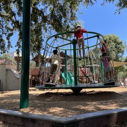
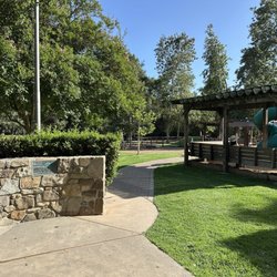
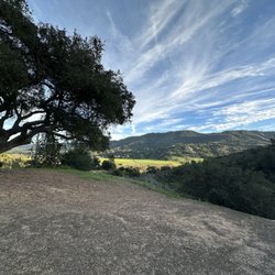
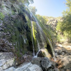
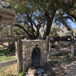
This is a small park located at the intersection of West Ojai Ave and Canada Street. Although in plain sight, it is a hidden gem. Take the time to stop and enjoy the view of the town and surrounding mountains. Enjoy the fountains and stream as well as the beautiful butterfly garden. Well worth the stop. read more
More info about Cluff Vista Park
324 West Ojai Ave
Ojai, CA 93023
Directions
Hours
Outdoor Amenities
You might also consider


Why does Yelp recommend reviews?
1 review that is not currently recommended
The reviews below are not factored into the business's overall star rating.
12 years ago
Cluff Vista Park - parks - Updated July 2026
Best of Ojai
People found Cluff Vista Park by searching for…
Trending Searches in Ojai, CA
Black Owned Nail Salons near Cluff Vista Park
Boardwalk near Cluff Vista Park
Boat Rental near Cluff Vista Park
Cliff Jumping near Cluff Vista Park
Day Trips near Cluff Vista Park
Dog Friendly Beaches near Cluff Vista Park
Fishing Pier near Cluff Vista Park
Jet Ski Rental near Cluff Vista Park
Kayak Rental near Cluff Vista Park
Kids Activities Outdoor near Cluff Vista Park
Lookout Points near Cluff Vista Park
Outdoor Basketball Courts near Cluff Vista Park
Picnic Spots near Cluff Vista Park
Places To Walk Around near Cluff Vista Park
Pool Day Pass near Cluff Vista Park
Public Beaches near Cluff Vista Park
Public Pools near Cluff Vista Park
River Swimming near Cluff Vista Park
River Tubing near Cluff Vista Park
Scenic Overlook near Cluff Vista Park
Soccer Store near Cluff Vista Park
Splash Pad near Cluff Vista Park
Swimming Holes near Cluff Vista Park
Swimming Lakes near Cluff Vista Park
Browse Articles
Browse Nearby
BEST of Ojai, California Things to Do near Cluff Vista Park
BEST of Ojai, California Coffee near Cluff Vista Park
BEST of Ojai, California Restaurants near Cluff Vista Park
BEST of Ojai, California Star Gazing near Cluff Vista Park
BEST of Ojai, California Playgrounds near Cluff Vista Park
BEST of Ojai, California Picnic Areas near Cluff Vista Park
BEST of Ojai, California Breakfast near Cluff Vista Park
Browse Brands
Related Searches in Ojai, CA
Best Off Leash Dog Parks in Ojai, California
Best Parks for Parties and Events in Ojai, California
Best Water Parks for Kids in Ojai, California
Check Out Great Playgrounds in Ojai, California
Discover Baseball Fields Around Ojai, California
Discover Beautiful Garden Spots in Ojai, California
Discover Free Parking Options in Ojai, California
Discover Fun Toddler Parks in Ojai, California for Your Little One
Discover Lakes & Ponds to Explore in Ojai, California
Discover Popular Photo Spots in Ojai, California
Discover Soccer Fields in Ojai, California Near You
Discover Top State Parks to Visit in Ojai, California
Discover the Best Beaches in Ojai, California
Discover the Best Kids Park Spots in Ojai, California
Enjoy the Best Picnic Spots and Ideas in Ojai, California
Enjoy the Best Walking Trails in Ojai, California
Explore Beautiful Botanical Gardens in Ojai, California
Explore Easy Hikes Perfect for All in Ojai, California
Explore Family-Friendly Zoos and Wildlife in Ojai, California
Explore Fun Activities to Do in Ojai, California
Explore Parks With Pull Up Bars in Ojai, California
Explore Popular Campgrounds Near Ojai, California
Explore Popular Picnic Areas Around Ojai, California
Explore Popular RV Parks Around Ojai, California
Explore Popular Recreation Centers Around Ojai, California
Explore Popular View Points Around Ojai, California
Explore Scenic Lakes to Visit in Ojai, California
Explore Top Dog Parks in Ojai, California Near You
Explore Top Water Parks in Ojai, California Today
Explore the Best Trail Options in Ojai, California
Find Parks and Recreation Activities in Ojai, California
Find Picnic Tables for Outdoor Fun in Ojai, California
Find Top Dog Friendly Parks to Visit in Ojai, California
Find Top Skate Parks in Ojai, California for All Skill Levels
Find Top-Rated Waterfalls in Ojai, California Now
Find a Park With BBQ Pits in Ojai, California
Find the Best Parks BBQ Grills in Ojai, California
Find the Best Parks for Picnics in Ojai, California
Have Fun at a Splash Pad in Ojai, California
Locate Tennis Courts Around Ojai, California
Parks With Basketball Courts for Games in Ojai, California
Picnic Areas With BBQ Pits Available in Ojai, California
Play at a Splash Pad Park in Ojai, California
Popular Places to Take Pictures in Ojai, California
Top Hiking Trails to Explore in Ojai, California
Top Places to Visit in Ojai, California for Sightseeing
Top Running Trails to Explore in Ojai, California
Top Swimming Lakes to Enjoy in Ojai, California