Cancel

    Open app

    Search

    Little Zigzag Falls

    4.7 (19 reviews)

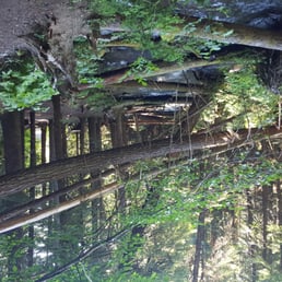
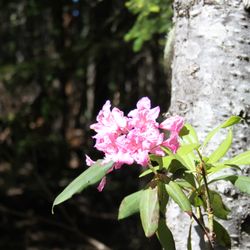
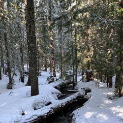
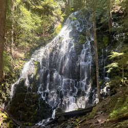
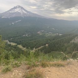
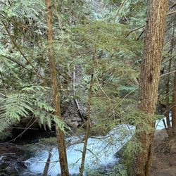
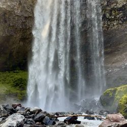
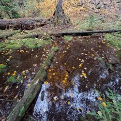
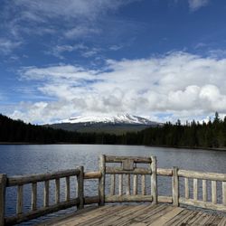
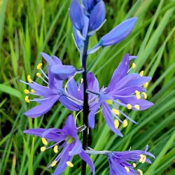
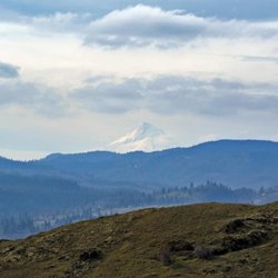
    Little Zigzag Falls Photos

    You might also consider

    Recommended Reviews - Little Zigzag Falls

    Your trust is our priority, so businesses can't pay to alter or remove their reviews. Learn more about reviews.
    Yelp app icon
    Browse more easily on the app
    Review Feed Illustration

    Reviews With Photos

    Emanuel S.

    Easy walk, air is awesome, beautiful. Lots of places to take pics. We went when there was a still snow and it was super nice.

    Little Zig Zag River did not disappoint!
    Jamie G.

    This nature walk was spectacular. Although it a short hike in and out, the adventures and scenes were marvelous This place can be a discovery place for children, and a great picnic area during a mid-day break from all the different hiking trails near by! There were a lot of people during this mid-week hike. Most people were wearing face coverings to adhere to the COVID-19 rules in Oregon. People did make room to allow groups to hike together. We will be back soon!

    Kim R.

    Finally got by to see Zig Zag in the snow. During this time of year you can't drive up to the trailhead. But it's an easy and short walk up from where they stop plowing. The trail itself was a tad rough while we were there, it needed another fresh coating of powder. But it was still just a short hike up to the falls and pretty in the snow. I must admit though, contrary to my general preference of hiking in the winter, I actually preferred the beauty of this trail in the summer.

    Zigzag Falls.
    Jennifer M.

    What a sweet little hike. Perfect for beginners and those with small children. The falls itself was lovely and there are places to sit and just absorb all of the peace and beauty! Pack a lunch and enjoy. Be warned though... it is a very short hike, so you may wish to also choose a trailhead nearby to hike as well.

    Beautiful falls
    Nicole Y.

    Enroute back to Portland, I wanted to squeeze in a short hike. I'm so glad that we were able to visit Little Zigzag Falls. The trailhead is clearly marked and it's a short walk to the falls. Today, it was a bit more challenging as the trail was covered in snow. After a short walk, we were at the falls. Awesome hike and beautiful views along the way!

    Emily R.

    What a wonderful little spot! This is a great short and easy hike that people who tire easy can complete. It only takes a few minutes to walk up to the falls and there are lots of good photo ops.

    PNWonderland
    Julia Y.

    Love this little gem out in the woods! 4 wheel drive or chains is a must during the winter but I think it's more beautiful. You have the snow hanging Off of the trees and by the waterfall. It's a short half mile walk thats mostly flat up to the waterfall. You walk by the stream the whole time so you'll never get lost. I also just let my dog off leash since there is rarely anyone there.

    Matt R.

    I try to finish every trip back from the mountain with a quick stop at Little Zig Zag. It's not far off the beaten path, and the short walk to the waterfall is a favorite. The forest is out of a fairytale, and visitors with even the littlest hiking experience can handle the trail.

    Chen Z.

    This was a very short hike. It took about 10 minutes to get to the end. At the last waterfall there is a small bench for seating. Relax and enjoy nature. Be sure to coat yourself with bug spray before you head in. This trail particularly has extra flesh eating insects.

    F H.

    My girlfriends and I loved Little Zig Zag Falls. The walk was super short and easy so great for kids. What's nice is that it's still a beautiful walk through the forest. The water is rushing and sounds wonderful. The views are also gorgeous. There are a ton of photo ops all over the place. It's a definite must see if you're in the area.
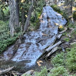
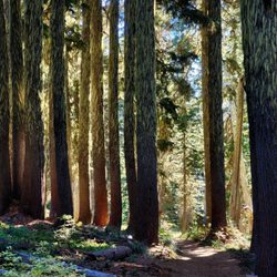
    June 3, 2013 Little Zigzag Falls
    Jess B.

    This was short and sweet but beautiful and relaxing. I will bring my grandparents here when they come visit.

    Francene G.

    short, easy hike. Big reward. Love this little mini-hike.

    See all

    2 years ago

    Helpful 4
    Thanks 0
    Love this 3
    Oh no 0

    9 months ago

    Helpful 0
    Thanks 0
    Love this 0
    Oh no 0

    2 years ago

    Helpful 2
    Thanks 0
    Love this 3
    Oh no 0

    1 year ago

    Helpful 0
    Thanks 0
    Love this 0
    Oh no 0

    6 years ago

    Helpful 4
    Thanks 0
    Love this 4
    Oh no 0
    Photo of Kim R.
    180
    1107
    3098

    4 years ago

    Helpful 4
    Thanks 0
    Love this 4
    Oh no 0

    4 years ago

    Helpful 0
    Thanks 0
    Love this 0
    Oh no 0

    8 years ago

    Helpful 5
    Thanks 0
    Love this 3
    Oh no 0

    7 years ago

    Helpful 1
    Thanks 0
    Love this 0
    Oh no 0

    8 years ago

    Helpful 1
    Thanks 0
    Love this 0
    Oh no 0

    7 years ago

    Helpful 0
    Thanks 0
    Love this 0
    Oh no 0
    Photo of Chen Z.
    261
    571
    4147

    10 years ago

    Helpful 3
    Thanks 0
    Love this 3
    Oh no 0

    4 years ago

    This was a perfect hike for a warm summer afternoon. The path was tree covered and following the river is so peaceful.

    Helpful 0
    Thanks 0
    Love this 0
    Oh no 0
    Photo of F H.
    0
    669
    2116

    9 years ago

    Helpful 0
    Thanks 0
    Love this 0
    Oh no 0

    8 years ago

    Helpful 1
    Thanks 0
    Love this 0
    Oh no 0
    Photo of Jess B.
    62
    38
    96

    13 years ago

    Helpful 1
    Thanks 0
    Love this 0
    Oh no 0

    9 years ago

    Helpful 0
    Thanks 0
    Love this 0
    Oh no 0
    Photo of Kelly K.
    62
    106
    124

    11 years ago

    Helpful 0
    Thanks 0
    Love this 0
    Oh no 0

    8 years ago

    Helpful 0
    Thanks 0
    Love this 0
    Oh no 0

    Ask the Community - Little Zigzag Falls

    Review Highlights - Little Zigzag Falls

    It's not far off the beaten path, and the short walk to the waterfall is a favorite.

    Mentioned in 3 reviews

    Read more highlights

    Verify this business for free

    People searched for Hiking 105 times last month within 15 miles of this business.

    Verify this business

    Tamanawas Falls - The river runs along the trail

    Tamanawas Falls

    4.8(37 reviews)
    29.9 km

    Tamanawas Falls is one of my favorite waterfalls I've seen in Oregon…read more I've hiked it twice now-- once this past summer with my cousin, and more recently, last week. The hike is about three and a half miles round trip, with about 600 feet in elevation gain. Some light scrambling is necessary to get up close to the waterfall. There is a decent sized parking area at the trail head. Parking is $5 or free with a valid recreation pass. The waterfall itself is a hundred foot tall curtain. While it's only about one third the size, the shape reminds me of Vernal Fall in Yosemite. The basalt underneath the waterfall is very pretty and interesting to examine. There were lots of yellow trees (in October) including maple and Tamarack. I've read that you can go behind this waterfall, but I did not, since I'm a chicken, and like to play it safe around water. The hike was a little harder than it sounds, but still definitely doable within a couple of hours. There are a few campgrounds nearby, including Sherwood, Pollalie, and Nottingham.

    We were in the area and wanted to do a little hike. We found the Tamanawas falls hike and was…read moredescribed as an easy to moderate hike. The first mile was an easy dirt path with a modest elevation climb. When you turn away from the highway and cross the creek the trail turns a little rocky. The next mile and a half of the trail is intermittent mud and a lot of areas quite rocky. When you're about 300 yards or so from the waterfalls you'll encounter a rock slide that is one long boulder hop with some areas -that are quite treacherous. Once you get past the mudslide it's a short walk to the payoff. The waterfall is very stunning. We sat and gathered ourselves close to the base and enjoyed the beautiful scenery. The hike back seemed a lot shorter because we knew what we were encountering. The hike was described as a 4 mile hike we clocked it closer to 5 miles. Not a big deal but if you can get past the Boulder scramble the payoff is worth it. We definitely will do this hike again if in the area. There is a 5 dollar parking fee or the America the beautiful park pass we leave on the dash. There is a kiosk for the five dollar option at the trail head.

    Photos
    Tamanawas Falls
    Tamanawas Falls
    Tamanawas Falls

    See all

    Mosier Creek Falls - Wildflower time

    Mosier Creek Falls

    4.3(8 reviews)
    51.5 km

    Best time for this hike is end of April and May when the wildflowers are in bloom and cover the…read morehillsides with purple widow's grass, yellow balsam root, blue lupine and lavendar bachelor buttons. It's my favorite time to be in this area! Best place to park is right before the Mosier Creek Bridge as you leave the tiny two block downtown area. As you begin the hike you come to the cemetery of the founding father's of this charming town. Continue for another 10 minutes to the falls and the swimming hole below. The falls are small, not like the 7 popular falls you see along the Old Historic Highway by Multnomah Falls, but still lovely. Continue on and up where views of the Columbia River from this vantage point are breathtaking. The river widens In this area and slight turns as it makes it's way through Mosier and onto Rowena making for a beautiful vista to take in and photo ops. Unlike at Rowena Plateau and Tom McCall Preserve, dogs are allowed on these trails.

    Pretty fun trail with a variety of sites!…read more There's a small parking area right in town just on the other side of the bridge from where the trail begins. You can make a very short hike of it and just go to the falls. Or you can continue on from there and complete the approximately 3 mile out and back with a small loop at the top...I recommend the latter. There's nice signage at the start explaining some trail details. You'll pass by a cool, tiny cemetery and venture on to the falls. Mosier Falls was a bit more substantial than I'd expected, set in a pretty canyon with an overlook for your viewing pleasure. Should you wish to continue on the trail...and you really should...you'll start up the side of the hill on switchbacks and stairs to the top. Tiny flowers popping up were blanketing the entire hillside, and I'm guessing it'll be quite a show in couple of weeks. After zigging and zagging multiple times you'll reach the top and come to an overview with spectacular views of the gorge. There's a bench there should you need a little rest or just wish to sit and take in the view for a bit. From the viewpoint you'll see the dirt trail continue on. It meanders further down to the end of the line...a short loop that offers even more gorge views. The trail is quite narrow and fairly unshaded most of the way and there are regular signs warning hikers of private property lines. We enjoyed it on a Saturday morning, along with quite a few other hikers. It's a decent workout, a pretty waterfall, and some beautiful gorge views...not too shabby!

    Photos
    Mosier Creek Falls
    Mosier Creek Falls
    Mosier Creek Falls - Mosier Creek Falls - Feb 2024

    See all

    Mosier Creek Falls - Feb 2024

    Catherine Creek Trail

    Catherine Creek Trail

    4.5(10 reviews)
    55.3 km

    A simple yet beautiful trail that is fully paved and meanders down towards the river providing…read morevast, expansive views of the magnificent Columbia River. If you visit during wildflower season, it's even more beautiful with colorful wildflowers covering the fields. This trail is one of the few ADA accessible, which I really appreciate. While I do not use a wheelchair, I do have a disability and my legs can not handle the dirt and rock trails that are uneven. So having a paved path means that I can enjoy the gorgeous nature in this area. Wildflower season ranges from end of March to June, but every year is different based on the weather. This year (2022) was a very cold and rainy spring which delayed and prolonged the season. In April the hills were covered in yellow balsomroot and then blue lupine. End of May and heading into June, the next wave of flowers brings shades of blue from the delicate cornflowers with California poppies providing vibrant pops of orange Along the way. It's stunning! Wildflower season is my favorite season! Along the path there are many benches for those wanting to just relax and chill; some in the shade, some in the sun. There are also placards providing info on the area, the wildflowers, and the importance of pollination. The Catherine Creek paved trail is south of the parking area, which is a gravel section along Highway 8. Cross the street, the access is just past the porta potty. If you want the Catherine Creek Arch trail, it is on the same side as the parking, just head up the hill on the dirt trail. It's an easy 1.5 mile paved path that does have some declines and inclines as you make your way down, around, and then back up. If you head clockwise, you can see the creek to your left. If you decide to go off the paved path down to the creek, know there is a lot of poison oak and ticks. I stayed on the path, which is clear and well maintained. Note for wheelchair users - the path is wide and paved, but there are some areas where it slopes down and then makes it way back up. Another great thing about Catherine Creek Trail and Catherine Creek Arch Loop is that parking is free, no day pass required. The parking area is on the smaller side and on weekends, especially during wildflower time, it does get crowded. I went midweek and there was plenty of parking and I only came across two people on the path. Great for people of all ages and skills. For expert hikers, do the Catherine Arch first then finish with Catherine Creek.

    The trailhead was pretty busy Saturday afternoon, but there's a decent amount of parking along Old…read moreHwy 8 at the head. There are trails on both sides of the Hwy...according to the trail map only two above 8 and one below within Catherine Creek, but another trail leads towards Coyote Wall. We only took one uphill loop this day. The trails are quite narrow and the footing mostly uneven and rocky. The views are stunning throughout, and the flowers are emerging. As the trails wind mostly through the open ridge there is almost no shade...sunblock sunblock! It's an enjoyable spot for a hike for sure, although for me not quite AS pretty as the nearby Labyrinth Trail. We will definitely return to complete the other trails...good times.

    Photos
    Catherine Creek Trail - Such an interesting and beautiful landscape, no matter the season.

    Such an interesting and beautiful landscape, no matter the season.

    Catherine Creek Trail
    Catherine Creek Trail

    See all

    Umbrella Falls Trail - Umbrella Falls

    Umbrella Falls Trail

    5.0(4 reviews)
    10.3 km

    If your thing is almost no effort for huge reward, consider checking out Umbrella Falls…read more Right now you can park at Meadows and you'll see the trail sign. A narrow, (worn out) paved, and very short trail will take you right down to the falls in a minute. The setting is gorgeous and the falls are stunning. From the top when you see the little stream it's hard to believe that small amount of water can make such a beautiful and wide display. You can also add Umbrella into other hikes should you crave more of an adventure...adding in Sahalie Falls makes a great trip. But almost anyone can take the short trip down to Umbrella right now...highly recommend.

    Hiking around a ski bowl in the off season is definitely cool. Something kinda creepy about those…read morechair lifts just sitting there above the abundant foliage and creeks. This hike also has some amazing waterfalls. I took the "Umbrella Falls, Sahalie Falls and Timberline Trail Loop" as it is described in AllTrails. It's a 10.7 mile loop with a good combination of easy, tree covered strolling and uphill pushes that are strenuous but not hard. I started at Hood Meadows, at the Umbrella Falls trailhead, but you can start many places. I recommend either downloading g or printing a map - there are many cross trails and it would be easy to take an unintentional detour. I went counterclockwise, so Umbrella Falls was literally the first thing I saw. Steps from the parking area. So beautiful, just picture ready. A couple miles along I came to Sahalie Falls. The scramble down to the base was super sketchy, so be careful! It's truly one of the prettiest waterfalls in the Mt. Hood Forest. Remember I said be careful? Ya, I took a hard fall at a small creek crossing. Don't be like me, test that footing and log before you put your weight on it. I fell sideways into the creek, then several more times trying to get out of it. I'm pretty bruised but okay - it's a reminder how the simplest thing can still be dangerous. Nature don't care about you, so be cautious out there. I know I'll be a lot more wary of where I place my feet. It was a warm day and nothing was broken, so I dried out and carried on. Hey, can I just say - my phone was in a Unicorn Beetle Supcase and it survived the ordeal without a scratch. Sexy and functional, I'll never put my phone in any other case (I'm a former Otterbox user. Go Unicorn Beetle or bust!) This hike is one of those you can only do when the snow is gone, and right now the weather is perfect. Enjoy!

    Photos
    Umbrella Falls Trail - Morning light.

    Morning light.

    Umbrella Falls Trail - Umbrella Falls. Steps from the parking lot.

    Umbrella Falls. Steps from the parking lot.

    Umbrella Falls Trail - Umbrella Falls trail

    See all

    Umbrella Falls trail

    Little Zigzag Falls - hiking - Updated May 2026

    Loading...
    Loading...
    Loading...