Mosier Creek Falls Photos


More like Mosier Creek Falls
Recommended Reviews - Mosier Creek Falls
Start your review...

Reviews With Photos


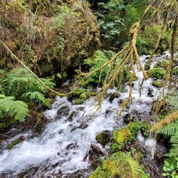
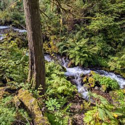
Simple, fantastic, quick hike with some beautiful falls as payoff. 4 people and 2 dogs hiked the little trail to the waterfalls after we found that dogs were strictly not allowed at the Rowena Plateau and Tom McCall Preserve (further out of Mosier town). You wouldn't know where to pick up this trail without a guide book, but you basically park after crossing the Mosier Creek bridge off exit 69. Hike up a bit and you see about 5 gravestones of the original founding family of Mosier. Really cool if you like that kind of thing. Keep going for 5-10 minutes till you get to the waterfall. There are some pretty photo ops, and you can precariously walk out on the crag and see the torrent beneath. We let the dogs off leash for a bit and they bounded on the grassy hillsides. (Beware of rattlers)(And ticks)(We didn't, and had to pick ticks for a while before leaving). But so worth it!

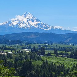
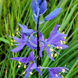
Best time for this hike is end of April and May when the wildflowers are in bloom and cover the hillsides with purple widow's grass, yellow balsam root, blue lupine and lavendar bachelor buttons. It's my favorite time to be in this area! Best place to park is right before the Mosier Creek Bridge as you leave the tiny two block downtown area. As you begin the hike you come to the cemetery of the founding father's of this charming town. Continue for another 10 minutes to the falls and the swimming hole below. The falls are small, not like the 7 popular falls you see along the Old Historic Highway by Multnomah Falls, but still lovely. Continue on and up where views of the Columbia River from this vantage point are breathtaking. The river widens In this area and slight turns as it makes it's way through Mosier and onto Rowena making for a beautiful vista to take in and photo ops. Unlike at Rowena Plateau and Tom McCall Preserve, dogs are allowed on these trails. read more


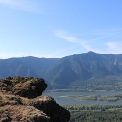
Pretty fun trail with a variety of sites! There's a small parking area right in town just on the other side of the bridge from where the trail begins. You can make a very short hike of it and just go to the falls. Or you can continue on from there and complete the approximately 3 mile out and back with a small loop at the top...I recommend the latter. There's nice signage at the start explaining some trail details. You'll pass by a cool, tiny cemetery and venture on to the falls. Mosier Falls was a bit more substantial than I'd expected, set in a pretty canyon with an overlook for your viewing pleasure. Should you wish to continue on the trail...and you really should...you'll start up the side of the hill on switchbacks and stairs to the top. Tiny flowers popping up were blanketing the entire hillside, and I'm guessing it'll be quite a show in couple of weeks. After zigging and zagging multiple times you'll reach the top and come to an overview with spectacular views of the gorge. There's a bench there should you need a little rest or just wish to sit and take in the view for a bit. From the viewpoint you'll see the dirt trail continue on. It meanders further down to the end of the line...a short loop that offers even more gorge views. The trail is quite narrow and fairly unshaded most of the way and there are regular signs warning hikers of private property lines. We enjoyed it on a Saturday morning, along with quite a few other hikers. It's a decent workout, a pretty waterfall, and some beautiful gorge views...not too shabby! read more


8 years ago
Cute little hillside hike. It's hard to find at first. It's right between residential areas, and behind a small cemetery. I wish it was easier to get to the "waterfall." The path is small, and probably not good for children or dogs. read more


18 years ago
Simple, fantastic, quick hike with some beautiful falls as payoff. 4 people and 2 dogs hiked the little trail to the waterfalls after we found that dogs were strictly not allowed at the Rowena Plateau and Tom McCall Preserve (further out of Mosier town). You wouldn't know where to pick up this trail without a guide book, but you basically park after crossing the Mosier Creek bridge off exit 69. Hike up a bit and you see about 5 gravestones of the original founding family of Mosier. Really cool if you like that kind of thing. Keep going for 5-10 minutes till you get to the waterfall. There are some pretty photo ops, and you can precariously walk out on the crag and see the torrent beneath. We let the dogs off leash for a bit and they bounded on the grassy hillsides. (Beware of rattlers)(And ticks)(We didn't, and had to pick ticks for a while before leaving). But so worth it! read more

8 years ago
Cool little hidden waterfall- beauty was unexpected so close to the interstate. Falls right into a little swimming hole that is rather deep. Super cold in September though. A very short hike. read more


10 years ago
10 years ago
More info about Mosier Creek Falls
207 3rd Ave
Mosier, OR 97040
Directions
Hours
Indoor Amenities
Outdoor Amenities
Ask the Community - Mosier Creek Falls


Mosier Creek Falls - hiking - Updated July 2026
Best of Mosier
People found Mosier Creek Falls by searching for…
Swimming Holes in Mosier, Oregon
Things to Do in Mosier, Oregon
Hiking Trails in Mosier, Oregon
Dog Friendly Hiking Trails in Mosier, Oregon
Swimming Lakes in Mosier, Oregon
Dog Friendly Parks in Mosier, Oregon
Scenic Overlook in Mosier, Oregon
Parks for Kids in Mosier, Oregon
Secret Spots in Mosier, Oregon
Walking Trails in Mosier, Oregon
River Swimming in Mosier, Oregon
Hiking With Kids in Mosier, Oregon
Waterfall Hike in Mosier, Oregon
Trending Searches in Mosier, OR
Browse Articles
Browse Nearby
BEST of Mosier, Oregon Restaurants near Mosier Creek Falls
BEST of Mosier, Oregon Parks near Mosier Creek Falls
BEST of Mosier, Oregon Coffee near Mosier Creek Falls
BEST of Mosier, Oregon Things to Do near Mosier Creek Falls
BEST of Mosier, Oregon Campgrounds near Mosier Creek Falls
BEST of Mosier, Oregon Photo Spots near Mosier Creek Falls
Browse Brands
Related Searches in Mosier, OR
Affordable Kayak Rental Services in Mosier, Oregon
Best Fishing Locations and Guides in Mosier, Oregon
Best Fun Things to Do in Mosier, Oregon
Best Places for Horseback Riding in Mosier, Oregon
Best Sledding Spots and Fun in Mosier, Oregon
Best Waterfalls and Swimming Holes in Mosier, Oregon
Discover Dog Friendly Trails to Explore in Mosier, Oregon
Discover Popular Photo Spots in Mosier, Oregon
Discover a Hiking Trail in Mosier, Oregon
Discover the Best Night Hike Trails in Mosier, Oregon
Dog-Friendly Hikes With Dogs in Mosier, Oregon
Enjoy Camping Adventures Around Mosier, Oregon
Enjoy Kayaking Adventures in Mosier, Oregon
Enjoy River Tubing Adventures in Mosier, Oregon
Enjoy Tent Camping Spots Around Mosier, Oregon
Enjoy a Beautiful Waterfall Hike in Mosier, Oregon
Enjoy the Best Family Activities in Mosier, Oregon
Enjoy the Best Walking Trails in Mosier, Oregon
Experience Thrilling White Water Rafting in Mosier, Oregon
Explore Beautiful Parks and Green Spaces in Mosier, Oregon
Explore Bike Rentals Throughout Mosier, Oregon
Explore Family-Friendly Zoos and Wildlife in Mosier, Oregon
Explore Free Things to Do Around Mosier, Oregon
Explore Fun Activities to Do in Mosier, Oregon
Explore Popular Campgrounds Near Mosier, Oregon
Explore Popular RV Parks Around Mosier, Oregon
Explore Popular View Points Around Mosier, Oregon
Explore Scenic Lakes to Visit in Mosier, Oregon
Explore Secret Spots Worth Visiting in Mosier, Oregon
Explore Top Dog Parks in Mosier, Oregon Near You
Explore the Best Beach Spots in Mosier, Oregon
Explore the Best Boating Spots in Mosier, Oregon
Explore the Best Swimming Holes Around Mosier, Oregon
Explore the Scenic River in Mosier, Oregon
Family Friendly Hiking With Kids in Mosier, Oregon
Find Popular Ziplining Spots Around Mosier, Oregon
Find the Best Playgrounds to Visit in Mosier, Oregon
Find the Best Scenic View Locations in Mosier, Oregon
Popular Fishing Spots to Explore in Mosier, Oregon
Popular Kids Activities in Mosier, Oregon
Popular Things to Do in Mosier, Oregon
Safe and Fun Parks for Kids in Mosier, Oregon
Top Climbing Spots and Gyms in Mosier, Oregon
Top Paddleboarding Activities in Mosier, Oregon
Top Playgrounds for Kids to Enjoy in Mosier, Oregon
Top Running Trails to Explore in Mosier, Oregon
Top Swimming Lakes to Enjoy in Mosier, Oregon
Top Swimming Spots and Pools in Mosier, Oregon
People who viewed Mosier Creek Falls also viewed
Wahclella Falls Hike
77 reviews
Coyote Wall Trailhead
4 reviews
Eagle Creek Trail
96 reviews
Pacific Crest National Scenic Trail
4 reviews
Tom McCall Point hike
7 reviews
Panther Creek Falls
16 reviews
Labyrinth Trail
1 review
Gillette Lake Hike
3 reviews
Tom McCall Preserve at Rowena
4 reviews
Wind Mountain Trailhead
2 reviews