Coyote Wall Trailhead Photos


More like Coyote Wall Trailhead
Recommended Reviews - Coyote Wall Trailhead
Start your review...

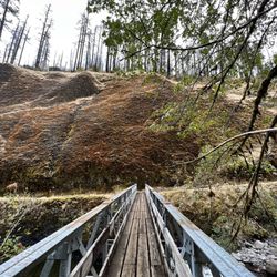
This hike kept coming up again and again in reviews, so I came to check it out and I just don't get it? I can see the appeal for mountain bikers but as a hiker there are so much prettier places around! This felt like a desolate land speckled with burned trees, dried out grass and black rock. This may hold a certain wind swept novelty for some but coming from the desert, not what I was looking for. Maybe it's best in the early spring? By late June the creeks were all dry. The trails were also confusing and didn't match the maps in my guides. There are signs posted that the government has taken to trying to consolidate the unauthorized mountain bike trails so this seems to be a work in progress. Also be careful out here, I ended up turning around because I was quite sure I saw a mountain lion hop into some trees higher on the ridge-line. Just my humble opinion as a tourist and wanted to share my 2 cents since was so highly regarded! read more


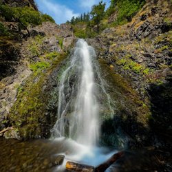
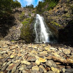
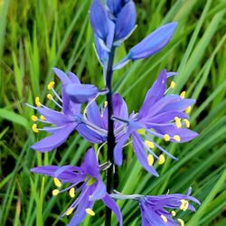
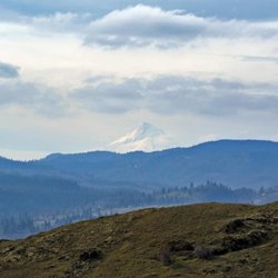
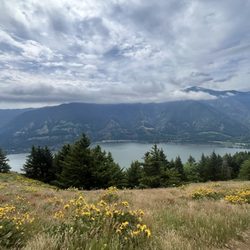
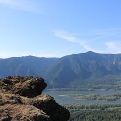
Hike is 6.47 miles, 1713 elevation gain, and took 2.5 hours. The views are great, we were on the tail end of enjoying the wildflowers and a lot were already beginning to wither away. The trails themselves are unfortunately very unclear and there are several short cuts which make it easy to loose the path if you're not paying attention to your navigation. The trails are also dusty, slippery, and steep in parts so beware in rainy conditions. On a clear day you also have a great view of Mt. Hood. This is a great alternative to the all too popular dog mountain. We were warned about rattle snakes but did not see a single one, though we did spot a few lizards and the dog gathered a couple of ticks. read more


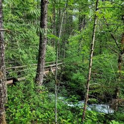
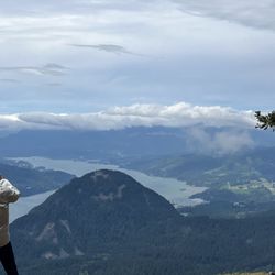
Just love Coyote Wall area hiking. We have hiked around Little Maui and Catherine Creek many times but hadn't ever started at the Wall Trailhead. Parking here on the weekends gets pretty limited. Now I know why, I hadn't realized that the Coyote section is such a biking draw. Taking the trail on 2 legs put us in the minority for sure, as we encountered mostly those on wheels. Unlike Catherine, Coyote has lots of little main trail off-shoots laid down by the bikes. We ended up going a few miles, opting to not go to the top but instead over to Maui (just a trickle at this time) and back around. Although the bike trail additions are there, the main trail is signed well. The footing is mostly rocky on the Wall side with a decent elevation gain, and dirt/rocks as you head away from it. Of course it tends to be pretty windy up there, but with endless views. Just a fun trail system. read more


More info about Coyote Wall Trailhead
Old Hwy 8
White Salmon, WA 98672
Directions
Hours
Outdoor Amenities


Coyote Wall Trailhead - hiking - Updated July 2026
Best of White Salmon
People found Coyote Wall Trailhead by searching for…
Hiking Trails in White Salmon, WA
Waterfall Hike in White Salmon, WA
Things to Do in White Salmon, WA
Scenic View in White Salmon, WA
Things to Do on a Rainy Day in White Salmon, WA
Mountain Biking in White Salmon, WA
Easy Hikes in White Salmon, WA
View Points in White Salmon, WA
Walking Trails in White Salmon, WA
Beautiful Views in White Salmon, WA
Swimming Holes in White Salmon, WA
Waterfalls in White Salmon, WA
Things to Do at Night in White Salmon, WA
Splash Pad in White Salmon, WA
Off Leash Dog Hikes in White Salmon, WA
Off Road Trails in White Salmon, WA
Running Trails in White Salmon, WA
Watch Sunset in White Salmon, WA
Swimming Lakes in White Salmon, WA
Trending Searches in White Salmon, WA
Blueberry Picking near Coyote Wall Trailhead
Boat Rental near Coyote Wall Trailhead
Cliff Jumping near Coyote Wall Trailhead
Day Trips near Coyote Wall Trailhead
Dog Friendly Trails near Coyote Wall Trailhead
Jet Ski Rental near Coyote Wall Trailhead
Kayak Rental near Coyote Wall Trailhead
Outdoor Activities near Coyote Wall Trailhead
Parks For Picnics near Coyote Wall Trailhead
Places To Swim near Coyote Wall Trailhead
Public Pools near Coyote Wall Trailhead
Public Shower near Coyote Wall Trailhead
River Swimming near Coyote Wall Trailhead
River Tubing near Coyote Wall Trailhead
Scenic Overlook near Coyote Wall Trailhead
Secluded Spots near Coyote Wall Trailhead
Soccer Store near Coyote Wall Trailhead
Splash Pad near Coyote Wall Trailhead
Swimming Holes near Coyote Wall Trailhead
Swimming Lakes near Coyote Wall Trailhead
U Pick Farms near Coyote Wall Trailhead
Browse Articles
Browse Nearby
Browse Brands
Related Searches in White Salmon, WA
Affordable Kayak Rental Services in White Salmon, Washington
Best Fishing Locations and Guides in White Salmon, Washington
Best Fun Things to Do in White Salmon, Washington
Best Places for Horseback Riding in White Salmon, Washington
Best Sledding Spots and Fun in White Salmon, Washington
Best Waterfalls and Swimming Holes in White Salmon, Washington
Discover Dog Friendly Trails to Explore in White Salmon, Washington
Discover Scenic Mountain Bike Trails Near White Salmon, Washington
Discover Top Boat Tours in White Salmon, Washington for All Ages
Discover a Hiking Trail in White Salmon, Washington
Discover the Best Night Hike Trails in White Salmon, Washington
Dog-Friendly Hikes With Dogs in White Salmon, Washington
Enjoy Kayaking Adventures in White Salmon, Washington
Enjoy Tent Camping Spots Around White Salmon, Washington
Enjoy a Beautiful Waterfall Hike in White Salmon, Washington
Enjoy the Best Family Activities in White Salmon, Washington
Enjoy the Best Tubing Experiences in White Salmon, Washington
Enjoy the Best Walking Trails in White Salmon, Washington
Experience Thrilling White Water Rafting in White Salmon, Washington
Explore Beautiful Parks and Green Spaces in White Salmon, Washington
Explore Bike Rentals Throughout White Salmon, Washington
Explore Easy Hikes Perfect for All in White Salmon, Washington
Explore Family-Friendly Zoos and Wildlife in White Salmon, Washington
Explore Free Things to Do Around White Salmon, Washington
Explore Fun Activities to Do in White Salmon, Washington
Explore Popular Campgrounds Near White Salmon, Washington
Explore Popular RV Parks Around White Salmon, Washington
Explore Popular View Points Around White Salmon, Washington
Explore Scenic Lakes to Visit in White Salmon, Washington
Explore Top Dog Parks in White Salmon, Washington Near You
Explore the Best Beach Spots in White Salmon, Washington
Explore the Best Boating Spots in White Salmon, Washington
Explore the Best Swimming Holes Around White Salmon, Washington
Family Friendly Hiking With Kids in White Salmon, Washington
Find Beautiful Views in White Salmon, Washington
Find Popular Ziplining Spots Around White Salmon, Washington
Find the Best Parks for Picnics in White Salmon, Washington
Find the Best Playgrounds to Visit in White Salmon, Washington
Find the Best Scenic View Locations in White Salmon, Washington
Hiking Trails With Waterfalls in White Salmon, Washington
Off Leash Dog Hiking Trails in White Salmon, Washington
Popular Fishing Spots to Explore in White Salmon, Washington
Popular Kids Activities in White Salmon, Washington
Popular Things to Do in White Salmon, Washington
Safe and Fun Parks for Kids in White Salmon, Washington
Top Paddleboarding Activities in White Salmon, Washington
Top Running Trails to Explore in White Salmon, Washington
Top Swimming Lakes to Enjoy in White Salmon, Washington