Starvation Creek State Park Photos


More like Starvation Creek State Park
Recommended Reviews - Starvation Creek State Park
Start your review...

Reviews With Photos

We came here and rode our bikes 9 miles. Trail was nice, you just have to watch for groups of people and bikers who are side by side so it's sometimes hard to get around and you have to totally slow down. The ranger said January 2024 it will go all the way to Hood River, can't wait for that but for now it was great and beautiful. Definitely a bit of a head wind one way today but still a great time and ride. I did purchase the yearly Oregon State Park pass since required for parking and we also do Banks Vernonia and go to enough places that the $30 for 12 months was so worth it.

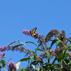
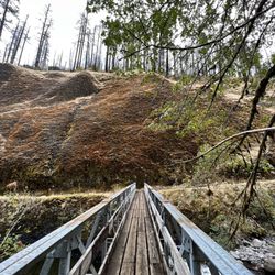
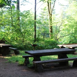
Great trails for biking and hiking, parking lot is small but there are other parks nearby and they all connect to the same path so you can always park farther away and still get here. The waterfalls can be seen off the path in most spots. Picnic benches and restrooms are well kept. Some trails are still closed due to the eagle creeks fire so make sure you research your trails before you head out. Hole in the wall falls was pretty interesting and learning the history of the name starvation creeks was fun.

With so many beautiful parks and trails along Columbia River Gorge's "Waterfall Alley", you might decide to drive right on past Starvation Creek on your way to Hood River from Portland (or vice versa), and that would be alright with me. The fewer folks that stop here, the more peaceful and pristine these falls will remain. I could not believe how lucky I was to have this place all to myself (well, along with my 10-year-old and his dad). We visited on a Friday afternoon in August and spent about an hour just marveling at the beauty here, with nary another soul gracing our path. After a brutal hike up to Angel's Rest (1200 feet of elevation gain!) on a previous day, we were so happy to be able to access these 190-feet, 2-tiered falls with just a short, easy walk from the parking/rest area. Without much effort at all, we were able to enjoy these falls, take plenty of pictures, and play a bit in the creek as if it were our own private oasis. From the restrooms, take the eastward path up the hill, following the right fork at the historical marker which tells the tale of a Union Pacific train stranded here during a snow storm in December 1884. You can see most of the falls from the shaded picnic tables, but if you want to get the best view, you need to be willing to do some dry climbing to the right, or some wet creek crossing to the left - your choice. For the creek, you'll want to wear some grippy water shoes, as those rocks are slippery. Bring your backpack of goodies and you'll find a nice concrete pad up top where you can have a sweet picnic or cold brew if you wish. This place was easily one of our favorite experiences while visiting Oregon. The following linked map is quite handy for choosing your stops along the Historic Columbia River Highway (HCRH): http://oregonstateparks.org/ckFiles/files/HCRH_BikeMaps.pdf And this hike guide gives info about the trails and other falls which can be reached via Starvation Creek State Park. https://gorgefriends.org/hike-the-gorge/starvation-creek-ridge-loop.html


This state park in the Gorge is being revamped to be more family and ADA friendly. While you can still get to the Mt. Defiance trail head from here or do the Starvation Creek Loop hike, there is now a mile long completely paved path with picnic tables along the routes to the waterfalls. It's great for those who might not be able to hike on uneven surfaces or for families the small children. Also, the cleanest state park bathroom I have ever been to was here. There's even soap!

2 years ago
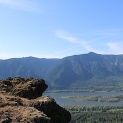
Never disappoints. Winter is less touristy but the water Colin is much better to make more and better waterfalls. There are spots with warnings of slides, beware and respect them - don't risk your safety. I even found still maturing blackberries that are bright red in mid December! And a bunch of cute looking mushrooms. The air is amazing. The gorge view is breathtaking and never gets old. Love it. read more


One of many great places to pull off the 84 and see waterfalls...but here you can park and easily walk to 3 in no time. Do yourself a favor and make this stop when heading east...otherwise you'll be loons like us and have to go past, come back east, and then east again in order to head back west. Worth the out-of-the-way loop? Yes! 3 nice falls for literally anyone with any walking ability. There's a decent sized lot, as well as restrooms. Starvation Falls is right there, just steps away from the lot. Head up the trail westward and you'll hit both Cabin Creek and Hole in the Wall Falls before you know it. I didn't time it exactly, but if you've got 30 mins I'm sure you can take it all 3. Each falls has its own character and gorgeous setting, as well as picnic tables at Starvation. Yes, ANOTHER stop along the 84 to see waterfalls. There are a couple others nearby should you have a bit more time to hike, but a short stroll gets you a sweet pic times 3! read more


We came here and rode our bikes 9 miles. Trail was nice, you just have to watch for groups of people and bikers who are side by side so it's sometimes hard to get around and you have to totally slow down. The ranger said January 2024 it will go all the way to Hood River, can't wait for that but for now it was great and beautiful. Definitely a bit of a head wind one way today but still a great time and ride. I did purchase the yearly Oregon State Park pass since required for parking and we also do Banks Vernonia and go to enough places that the $30 for 12 months was so worth it. read more


5 years ago
Great trails for biking and hiking, parking lot is small but there are other parks nearby and they all connect to the same path so you can always park farther away and still get here. The waterfalls can be seen off the path in most spots. Picnic benches and restrooms are well kept. Some trails are still closed due to the eagle creeks fire so make sure you research your trails before you head out. Hole in the wall falls was pretty interesting and learning the history of the name starvation creeks was fun. read more


2 years ago
9 years ago
With so many beautiful parks and trails along Columbia River Gorge's "Waterfall Alley", you might decide to drive right on past Starvation Creek on your way to Hood River from Portland (or vice versa), and that would be alright with me. The fewer folks that stop here, the more peaceful and pristine these falls will remain. I could not believe how lucky I was to have this place all to myself (well, along with my 10-year-old and his dad). We visited on a Friday afternoon in August and spent about an hour just marveling at the beauty here, with nary another soul gracing our path. After a brutal hike up to Angel's Rest (1200 feet of elevation gain!) on a previous day, we were so happy to be able to access these 190-feet, 2-tiered falls with just a short, easy walk from the parking/rest area. Without much effort at all, we were able to enjoy these falls, take plenty of pictures, and play a bit in the creek as if it were our own private oasis. From the restrooms, take the eastward path up the hill, following the right fork at the historical marker which tells the tale of a Union Pacific train stranded here during a snow storm in December 1884. You can see most of the falls from the shaded picnic tables, but if you want to get the best view, you need to be willing to do some dry climbing to the right, or some wet creek crossing to the left - your choice. For the creek, you'll want to wear some grippy water shoes, as those rocks are slippery. Bring your backpack of goodies and you'll find a nice concrete pad up top where you can have a sweet picnic or cold brew if you wish. This place was easily one of our favorite experiences while visiting Oregon. The following linked map is quite handy for choosing your stops along the Historic Columbia River Highway (HCRH): http://oregonstateparks.org/ckFiles/files/HCRH_BikeMaps.pdf And this hike guide gives info about the trails and other falls which can be reached via Starvation Creek State Park. https://gorgefriends.org/hike-the-gorge/starvation-creek-ridge-loop.html read more


Spectacular waterfall, especially if you climb to the base of the main falls (easy). Look up at the wispy spray and feel the downdraft. Small parking lot, but this is along the gorge trail so you can hike here from nearby areas. Worth a visit just to see this alone. read more


7 years ago
What a wonderful experience hiking for the first time! Leisurely for the first hike. Beautiful Waterfalls! I was so amazed to experience the clean restroom . Liked that there was a sign about the History of Why & How? It got its name Starvation Creek. read more


This state park in the Gorge is being revamped to be more family and ADA friendly. While you can still get to the Mt. Defiance trail head from here or do the Starvation Creek Loop hike, there is now a mile long completely paved path with picnic tables along the routes to the waterfalls. It's great for those who might not be able to hike on uneven surfaces or for families the small children. Also, the cleanest state park bathroom I have ever been to was here. There's even soap! read more


8 years ago
10 years ago
5 years ago
9 years ago
The waterfall is absolutely beautiful! We went on one of the hikes as well, and the trail was maintained and clean for most of the way. We passed beautiful creeks and so much nature on the way. We did climb, and I love that there are fences that keep the rocks from falling onto you on the first part of the trail as we rose in elevation. We took our two kids (18, 7) and family friends kid (15) and they all did well. Favorite part of the hike had to be the waterfall views though and that was on the other side. I love that the hike was pretty private, we only passed two couples on the way back and saw a few people at the waterfall. Definitely wanting to go back soon! read more


8 years ago
More info about Starvation Creek State Park
Starvation Ridge Trl
Cascade Locks, OR 97014
Directions
Visit Website
http://www.oregonstateparks.org/index.cfm?do=parkPage.dsp_parkPage&parkId=122
Hours
Indoor Amenities
Outdoor Amenities
Ask the Community - Starvation Creek State Park
Review Highlights - Starvation Creek State Park


Starvation Creek State Park - hiking - Updated August 2026
Best of Cascade Locks
People found Starvation Creek State Park by searching for…
Campgrounds in Cascade Locks, OR
Dog Parks in Cascade Locks, OR
Hiking Trails With Waterfalls in Cascade Locks, OR
Playgrounds in Cascade Locks, OR
Scenic View in Cascade Locks, OR
Dog Friendly Hiking Trails in Cascade Locks, OR
Things to Do in Cascade Locks, OR
Secret Spots in Cascade Locks, OR
Camping Sites in Cascade Locks, OR
Easy Hikes in Cascade Locks, OR
View Points in Cascade Locks, OR
Secluded Spots in Cascade Locks, OR
Swimming Lakes in Cascade Locks, OR
Waterfalls in Cascade Locks, OR
Places to Take Pictures in Cascade Locks, OR
Scenic Overlook in Cascade Locks, OR
Playgrounds for Kids in Cascade Locks, OR
Waterfalls and Swimming Holes in Cascade Locks, OR
Natural Hot Springs in Cascade Locks, OR
Parks for Kids in Cascade Locks, OR
Things to Do at Night in Cascade Locks, OR
Off Road Trails in Cascade Locks, OR
Trending Searches in Cascade Locks, OR
Blueberry Picking near Starvation Creek State Park
Boating near Starvation Creek State Park
Cinema near Starvation Creek State Park
Cruising Spots near Starvation Creek State Park
Dog Friendly Beaches near Starvation Creek State Park
Dog Friendly Things To Do near Starvation Creek State Park
Dog Swimming near Starvation Creek State Park
Indoor Mini Golf near Starvation Creek State Park
Jet Skis near Starvation Creek State Park
Kayak Rental near Starvation Creek State Park
Kids Activities Indoor near Starvation Creek State Park
Lakes near Starvation Creek State Park
Lookout Points near Starvation Creek State Park
Outdoor Activities near Starvation Creek State Park
Parks near Starvation Creek State Park
Peach Picking near Starvation Creek State Park
Playgrounds near Starvation Creek State Park
River Swimming near Starvation Creek State Park
Rock Quarry near Starvation Creek State Park
Scenic Drive near Starvation Creek State Park
Sunrise View near Starvation Creek State Park
Surf Shop near Starvation Creek State Park
Swimming Holes near Starvation Creek State Park
Things To Do On A Rainy Day near Starvation Creek State Park
Things To Do With Kids near Starvation Creek State Park
Watch Sunset near Starvation Creek State Park
Browse Articles
Browse Nearby
Browse Brands
Related Searches in Cascade Locks, OR
Affordable Kayak Rental Services in Cascade Locks, Oregon
Best Dog Hiking Trails Around Cascade Locks, Oregon
Best Fishing Locations and Guides in Cascade Locks, Oregon
Best Off Leash Dog Parks in Cascade Locks, Oregon
Best Parks for Parties and Events in Cascade Locks, Oregon
Best Places for Horseback Riding in Cascade Locks, Oregon
Best Water Parks for Kids in Cascade Locks, Oregon
Check Out Great Playgrounds in Cascade Locks, Oregon
Discover Baseball Fields Around Cascade Locks, Oregon
Discover Dog Friendly Trails to Explore in Cascade Locks, Oregon
Discover Lakes & Ponds to Explore in Cascade Locks, Oregon
Discover Soccer Fields in Cascade Locks, Oregon Near You
Discover Top Nature Parks to Visit in Cascade Locks, Oregon
Discover Top State Parks to Visit in Cascade Locks, Oregon
Discover a Hiking Trail in Cascade Locks, Oregon
Discover the Best Beaches in Cascade Locks, Oregon
Discover the Best Fishing Lake in Cascade Locks, Oregon
Discover the Best Night Hike Trails in Cascade Locks, Oregon
Dog-Friendly Hikes With Dogs in Cascade Locks, Oregon
Enjoy Camping Adventures Around Cascade Locks, Oregon
Enjoy Kayaking Adventures in Cascade Locks, Oregon
Enjoy Off Leash Dog Hikes in Cascade Locks, Oregon
Enjoy Tent Camping Spots Around Cascade Locks, Oregon
Enjoy a Beautiful Waterfall Hike in Cascade Locks, Oregon
Enjoy the Best Walking Trails in Cascade Locks, Oregon
Experience Thrilling White Water Rafting in Cascade Locks, Oregon
Explore Beautiful Parks and Green Spaces in Cascade Locks, Oregon
Explore Easy Hikes Perfect for All in Cascade Locks, Oregon
Explore Family-Friendly Zoos and Wildlife in Cascade Locks, Oregon
Explore Free Picnic Areas Around Cascade Locks, Oregon
Explore Fun Activities to Do in Cascade Locks, Oregon
Explore Parks With Pull Up Bars in Cascade Locks, Oregon
Explore Picnic Parks Near Cascade Locks, Oregon
Explore Popular Campgrounds Near Cascade Locks, Oregon
Explore Popular Kids Parks Throughout Cascade Locks, Oregon
Explore Popular Picnic Areas Around Cascade Locks, Oregon
Explore Popular RV Parks Around Cascade Locks, Oregon
Explore Scenic Lakes to Visit in Cascade Locks, Oregon
Explore Top Dog Parks in Cascade Locks, Oregon Near You
Explore Top Water Parks in Cascade Locks, Oregon Today
Explore the Best Beach Spots in Cascade Locks, Oregon
Explore the Best Swimming Holes Around Cascade Locks, Oregon
Family Friendly Hiking With Kids in Cascade Locks, Oregon
Find Beautiful Views in Cascade Locks, Oregon
Find Great Places to Feed Ducks in Cascade Locks, Oregon
Find Parks and Recreation Activities in Cascade Locks, Oregon
Find Popular Ziplining Spots Around Cascade Locks, Oregon
Find Public Tennis Courts in Cascade Locks, Oregon
Find Top Dog Friendly Parks to Visit in Cascade Locks, Oregon


