Labyrinth Trail Photos


More like Labyrinth Trail
Recommended Reviews - Labyrinth Trail
Start your review...

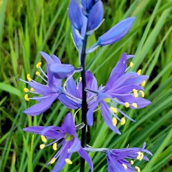
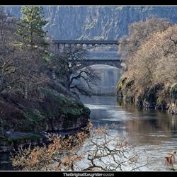
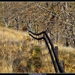
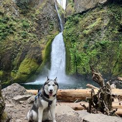
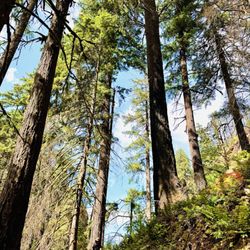
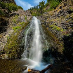
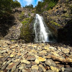
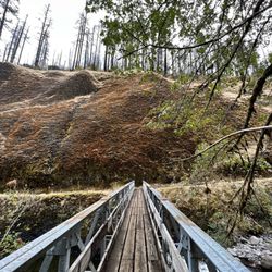
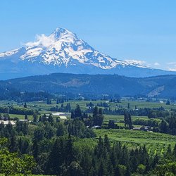
I LOVED this trail. So much fun with so much to see along the way and gorgeous views of the gorge and Mt Hood. The Labyrinth links to a few trails including Coyote Wall. Although the Labyrinth alone is shown as a 3 1/2 mile out and back there is a link trail at Labyrinth Falls that shoots over the ridge and towards Little Maui Falls Trail and Coyote, as well as a signed junction pointing you towards each falls. These trails are clearly popular with bikers and hikers. Signage states that dogs have to be leashed December to July. Aside from the constant epic views, the landscape is unique with streams, falls, springtime flowers, and (I assume) ground squirrels popping up and down from their homes. We started at the trailhead at the junction of Old Hwy 8 and the 14 at Rowland Lake. There's a small parking area there with more parking along the 8. The trail actually starts by heading up the semi-creepy abandoned hwy 8 where you'll quickly encounter Lower Labyrinth Falls. Soon you'll encounter trail signage that'll lead you on your way. Just a stunning trail, other worldly. We only covered part of the trails available in the area and can't wait to return for more! read more


More info about Labyrinth Trail
Old Hwy 8
Lyle, WA 98635
Directions
Hours
Outdoor Amenities


Labyrinth Trail - hiking - Updated June 2026
Best of Lyle
People found Labyrinth Trail by searching for…
Things to Do in Lyle, Washington
Hiking Trails in Lyle, Washington
Waterfall Hike in Lyle, Washington
Scenic View in Lyle, Washington
View Points in Lyle, Washington
Beautiful Views in Lyle, Washington
Things to Do at Night in Lyle, Washington
Waterfalls in Lyle, Washington
Walking Trails in Lyle, Washington
Swimming Holes in Lyle, Washington
Splash Pad in Lyle, Washington
Running Trails in Lyle, Washington
Lakes & Ponds in Lyle, Washington
Off Leash Dog Hikes in Lyle, Washington
Watch Sunset in Lyle, Washington
Sunset View in Lyle, Washington
Swimming Lakes in Lyle, Washington
Dog Friendly Trails in Lyle, Washington
Trending Searches in Lyle, WA
Berry Picking near Labyrinth Trail
Blueberry Picking near Labyrinth Trail
Boat Rental near Labyrinth Trail
Dog Friendly Trails near Labyrinth Trail
Fishing Spots near Labyrinth Trail
Fruit Picking near Labyrinth Trail
Jet Ski Rental near Labyrinth Trail
Kayak Rental near Labyrinth Trail
Peach Picking near Labyrinth Trail
Pick Your Own Farms near Labyrinth Trail
Places To Swim near Labyrinth Trail
Public Shower near Labyrinth Trail
River Tubing near Labyrinth Trail
Splash Pad near Labyrinth Trail
Strawberry Picking near Labyrinth Trail
Swimming Holes near Labyrinth Trail
Browse Articles
Browse Nearby
Browse Brands
Related Searches in Lyle, WA
Affordable Kayak Rental Services in Lyle, Washington
Best Fishing Locations and Guides in Lyle, Washington
Best Nature Trails for Hiking in Lyle, Washington
Best Spots for Star Gazing in Lyle, Washington
Check Out Off Road Trails in Lyle, Washington
Discover Dog Friendly Trails to Explore in Lyle, Washington
Discover Popular Bike Trails in Lyle, Washington
Discover Popular Photo Spots in Lyle, Washington
Discover Scenic Mountain Bike Trails Near Lyle, Washington
Discover Top Nature Parks to Visit in Lyle, Washington
Discover a Hiking Trail in Lyle, Washington
Discover the Best Night Hike Trails in Lyle, Washington
Discover the Best Running Track in Lyle, Washington
Dog-Friendly Hikes With Dogs in Lyle, Washington
Enjoy Scenic Night View Experiences in Lyle, Washington
Enjoy Water Activities and Fun in Lyle, Washington
Enjoy the Best Picnic Spots and Ideas in Lyle, Washington
Enjoy the Best Walking Trails in Lyle, Washington
Exciting Cliff Jumping Spots in Lyle, Washington
Experience Stunning Sunset Views in Lyle, Washington
Explore Beautiful Parks and Green Spaces in Lyle, Washington
Explore Bike Rentals Throughout Lyle, Washington
Explore Easy Hikes Perfect for All in Lyle, Washington
Explore Family-Friendly Zoos and Wildlife in Lyle, Washington
Explore Popular Campgrounds Near Lyle, Washington
Explore Popular RV Parks Around Lyle, Washington
Explore Scenic Lakes to Visit in Lyle, Washington
Explore the Best Swimming Holes Around Lyle, Washington
Family Friendly Hiking With Kids in Lyle, Washington
Find Beautiful Views in Lyle, Washington
Find Fun Kids Activities Outdoor in Lyle, Washington
Find Parks and Recreation Activities in Lyle, Washington
Find Top Dog Friendly Parks to Visit in Lyle, Washington
Find the Best Parks for Picnics in Lyle, Washington
Find the Best Swimming Pools in Lyle, Washington Today
Hiking Trails With Waterfalls in Lyle, Washington
Off Leash Dog Hiking Trails in Lyle, Washington
Perfect Spots to Watch Sunset in Lyle, Washington
Plan Nature Center Visits in Lyle, Washington
Plan a Scenic Drive Route Near Lyle, Washington
Popular Fishing Spots to Explore in Lyle, Washington
Popular Places to Take Pictures in Lyle, Washington
Popular Things to Do in Lyle, Washington
Safe River Swimming Areas in Lyle, Washington
Safe and Fun Parks for Kids in Lyle, Washington
Top Paddleboarding Activities in Lyle, Washington
Top Running Trails to Explore in Lyle, Washington
Top Swimming Lakes to Enjoy in Lyle, Washington
People who viewed Labyrinth Trail also viewed
Coyote Wall Trailhead
3 reviews
Catherine Creek Trail
10 reviews
Hamilton Mountain Trail
10 reviews
Starvation Creek State Park
16 reviews
Gillette Lake Hike
3 reviews
Dog Mountain Trail
32 reviews
Mosier Twin Tunnels
3 reviews
Tom McCall Point hike
7 reviews
Tamanawas Falls
38 reviews
Columbia Hills Historic State Park
6 reviews