Catherine Creek Trail Photos


More like Catherine Creek Trail
Recommended Reviews - Catherine Creek Trail
Start your review...

Reviews With Photos
 magazine, May/June 2021 issue.")
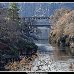
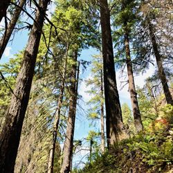
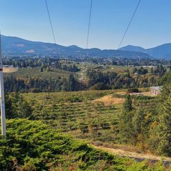
This place is a wonderful place to visit and absolutely beautiful in any season. We recently visited in mid/late Autumn and even with the cloudy day it was such a spectacular view. Just the scenic drive out here from Vancouver, WA or Portland, OR is worth the trek. There is a porta-potty and map at the trailhead, but I didn't notice maps anywhere else. The portion of the trail on the Columbia River Gorge side of the road has a paved loop, and a good portion of it could be enjoyed by those in a wheelchair or with mobility issues. That area on the river side also has several earthen trails throughout for more of a workout exploring & climbing inclines. On the other side of the road the park & trails are far more expansive on earthen trails that can be rocky & uneven, along with varying degrees of steep inclines and possibly some muddy spots, depending on the recent weather & time of year. There is also little to no shade here, and it can get incredibly hot here in the Summer, so wear sunblock & a hat on sunny days, and stay hydrated. There are several great places to eat & grab a drink in the nearby towns only 10 minutes away.

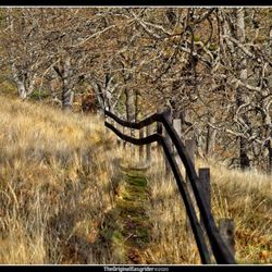
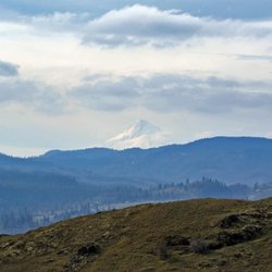
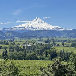
The most wonderful place for a day hike for spring wildflowers in the Gorge. There are several "paths" that you can take, all leading uphill on the vast south-facing slope north of the Columbia River. On clear days you see Mt. Hood to the south and a full view of the river and Mosier, Or. But it is all about the flowers. 82 species blooming in sequence. This year (mid-April) the blue camas was in full flower; the lupines were not out yet. Go in April to May, after that the grasses turn brown and it gets hot. Only 4 stars due to the large amount of horrible Poison Oak near the creek and in the trees. Stay on the open grasslands to avoid. We have seen a skunk! and also a rattlesnake here! exciting!

A simple yet beautiful trail that is fully paved and meanders down towards the river providing vast, expansive views of the magnificent Columbia River. If you visit during wildflower season, it's even more beautiful with colorful wildflowers covering the fields. This trail is one of the few ADA accessible, which I really appreciate. While I do not use a wheelchair, I do have a disability and my legs can not handle the dirt and rock trails that are uneven. So having a paved path means that I can enjoy the gorgeous nature in this area. Wildflower season ranges from end of March to June, but every year is different based on the weather. This year (2022) was a very cold and rainy spring which delayed and prolonged the season. In April the hills were covered in yellow balsomroot and then blue lupine. End of May and heading into June, the next wave of flowers brings shades of blue from the delicate cornflowers with California poppies providing vibrant pops of orange Along the way. It's stunning! Wildflower season is my favorite season! Along the path there are many benches for those wanting to just relax and chill; some in the shade, some in the sun. There are also placards providing info on the area, the wildflowers, and the importance of pollination. The Catherine Creek paved trail is south of the parking area, which is a gravel section along Highway 8. Cross the street, the access is just past the porta potty. If you want the Catherine Creek Arch trail, it is on the same side as the parking, just head up the hill on the dirt trail. It's an easy 1.5 mile paved path that does have some declines and inclines as you make your way down, around, and then back up. If you head clockwise, you can see the creek to your left. If you decide to go off the paved path down to the creek, know there is a lot of poison oak and ticks. I stayed on the path, which is clear and well maintained. Note for wheelchair users - the path is wide and paved, but there are some areas where it slopes down and then makes it way back up. Another great thing about Catherine Creek Trail and Catherine Creek Arch Loop is that parking is free, no day pass required. The parking area is on the smaller side and on weekends, especially during wildflower time, it does get crowded. I went midweek and there was plenty of parking and I only came across two people on the path. Great for people of all ages and skills. For expert hikers, do the Catherine Arch first then finish with Catherine Creek. read more


The trailhead was pretty busy Saturday afternoon, but there's a decent amount of parking along Old Hwy 8 at the head. There are trails on both sides of the Hwy...according to the trail map only two above 8 and one below within Catherine Creek, but another trail leads towards Coyote Wall. We only took one uphill loop this day. The trails are quite narrow and the footing mostly uneven and rocky. The views are stunning throughout, and the flowers are emerging. As the trails wind mostly through the open ridge there is almost no shade...sunblock sunblock! It's an enjoyable spot for a hike for sure, although for me not quite AS pretty as the nearby Labyrinth Trail. We will definitely return to complete the other trails...good times. read more


This is such a beautiful hike. My family visited in early July and enjoyed the wildflowers and Mt. Hood views on the south side of the highway. The paved loop was perfect for our newest hiker, my two year old. There were clean portapotties and plenty of parking. read more


This place is a wonderful place to visit and absolutely beautiful in any season. We recently visited in mid/late Autumn and even with the cloudy day it was such a spectacular view. Just the scenic drive out here from Vancouver, WA or Portland, OR is worth the trek. There is a porta-potty and map at the trailhead, but I didn't notice maps anywhere else. The portion of the trail on the Columbia River Gorge side of the road has a paved loop, and a good portion of it could be enjoyed by those in a wheelchair or with mobility issues. That area on the river side also has several earthen trails throughout for more of a workout exploring & climbing inclines. On the other side of the road the park & trails are far more expansive on earthen trails that can be rocky & uneven, along with varying degrees of steep inclines and possibly some muddy spots, depending on the recent weather & time of year. There is also little to no shade here, and it can get incredibly hot here in the Summer, so wear sunblock & a hat on sunny days, and stay hydrated. There are several great places to eat & grab a drink in the nearby towns only 10 minutes away. read more
 magazine, May/June 2021 issue. - Hiking Near Me - Lyle, Washington")


16 years ago
The most wonderful place for a day hike for spring wildflowers in the Gorge. There are several "paths" that you can take, all leading uphill on the vast south-facing slope north of the Columbia River. On clear days you see Mt. Hood to the south and a full view of the river and Mosier, Or. But it is all about the flowers. 82 species blooming in sequence. This year (mid-April) the blue camas was in full flower; the lupines were not out yet. Go in April to May, after that the grasses turn brown and it gets hot. Only 4 stars due to the large amount of horrible Poison Oak near the creek and in the trees. Stay on the open grasslands to avoid. We have seen a skunk! and also a rattlesnake here! exciting! read more


6 years ago
15 years ago
11 years ago
beautiful views of columbia river and abundant wildflowers in spring. best to visit in spring read more


More info about Catherine Creek Trail
Ask the Community - Catherine Creek Trail
Review Highlights - Catherine Creek Trail


Catherine Creek Trail - hiking - Updated July 2026
Best of Lyle
People found Catherine Creek Trail by searching for…
Trending Searches in Lyle, WA
Berry Picking near Catherine Creek Trail
Blueberry Picking near Catherine Creek Trail
Dog Friendly Trails near Catherine Creek Trail
Fruit Picking near Catherine Creek Trail
Jet Ski Rental near Catherine Creek Trail
Kayak Rental near Catherine Creek Trail
Lavender Farm near Catherine Creek Trail
Paddle Board Rental near Catherine Creek Trail
Parks For Picnics near Catherine Creek Trail
Peach Picking near Catherine Creek Trail
Places To Swim near Catherine Creek Trail
Public Shower near Catherine Creek Trail
River Swimming near Catherine Creek Trail
River Tubing near Catherine Creek Trail
Scenic Overlook near Catherine Creek Trail
Swimming Holes near Catherine Creek Trail
Swimming Lakes near Catherine Creek Trail
U Pick Farms near Catherine Creek Trail
Browse Articles
Browse Nearby
Browse Brands
Related Searches in Lyle, WA
Affordable Kayak Rental Services in Lyle, Washington
Best Dog Hiking Trails Around Lyle, Washington
Best Fishing Locations and Guides in Lyle, Washington
Best Places for Horseback Riding in Lyle, Washington
Best Sledding Spots and Fun in Lyle, Washington
Best Waterfalls and Swimming Holes in Lyle, Washington
Discover Dog Friendly Trails to Explore in Lyle, Washington
Discover a Hiking Trail in Lyle, Washington
Discover the Best Night Hike Trails in Lyle, Washington
Dog-Friendly Hikes With Dogs in Lyle, Washington
Enjoy Camping Adventures Around Lyle, Washington
Enjoy Kayaking Adventures in Lyle, Washington
Enjoy Off Leash Dog Hikes in Lyle, Washington
Enjoy Tent Camping Spots Around Lyle, Washington
Enjoy the Best Walking Trails in Lyle, Washington
Exciting Things to Do in Lyle, Washington Today
Experience Thrilling White Water Rafting in Lyle, Washington
Explore Beautiful Parks and Green Spaces in Lyle, Washington
Explore Bike Rentals Throughout Lyle, Washington
Explore Easy Hikes Perfect for All in Lyle, Washington
Explore Fun Activities to Do in Lyle, Washington
Explore Popular Campgrounds Near Lyle, Washington
Explore Popular RV Parks Around Lyle, Washington
Explore Scenic Lakes to Visit in Lyle, Washington
Explore Secret Spots Worth Visiting in Lyle, Washington
Explore Top Dog Parks in Lyle, Washington Near You
Explore the Best Beach Spots in Lyle, Washington
Explore the Best Swimming Holes Around Lyle, Washington
Family Friendly Hiking With Kids in Lyle, Washington
Find Popular Ziplining Spots Around Lyle, Washington
Find Top-Rated Waterfalls in Lyle, Washington Now
Find the Best Parks for Picnics in Lyle, Washington
Find the Best Playgrounds to Visit in Lyle, Washington
Find the Best Scenic View Locations in Lyle, Washington
Great Places to Swim in Lyle, Washington
Hiking Trails With Waterfalls in Lyle, Washington
Off Leash Dog Hiking Trails in Lyle, Washington
Popular Fishing Spots to Explore in Lyle, Washington
Popular Kids Activities in Lyle, Washington
Popular Things to Do in Lyle, Washington
Safe and Fun Parks for Kids in Lyle, Washington
Top Hiking Trails to Explore in Lyle, Washington
Top Playgrounds for Kids to Enjoy in Lyle, Washington
Top Swimming Lakes to Enjoy in Lyle, Washington
Top Swimming Spots and Pools in Lyle, Washington
Top-Rated Camping Sites in Lyle, Washington
People who viewed Catherine Creek Trail also viewed
Mosier Twin Tunnels
3 reviews
Horsethief Lake State Park
12 reviews
Pacific Crest National Scenic Trail
4 reviews
Wahclella Falls Hike
77 reviews
Labyrinth Trail
1 review
Coyote Wall Trailhead
4 reviews
Columbia River Gorge National Scenic Area
99 reviews
Eagle Creek Trail
96 reviews
Columbia Hills Historic State Park
6 reviews
Tom McCall Preserve at Rowena
4 reviews