Dog Mountain Trail Photos


More like Dog Mountain Trail
Recommended Reviews - Dog Mountain Trail
Start your review...

Reviews With Photos

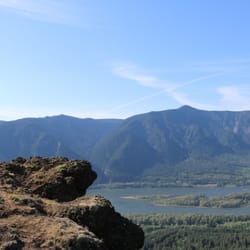
Minus one star for things that have nothing to do with the natural beauty of this place. Parking, crowds... you know. But if you go off season, like we did, you can avoid those annoyances. No green meadows, no delicate emerging flowers, the hike in late fall is a snapshot of nature getting ready to settle down for the winter. But check out my photos. The sun coming through the clouds is picture perfect. We knew it would be cold, but we weren't expecting the frost on the ground. And when we crossed the high, open areas the wind cut through like an icy knife. But so what! We had the trail to ourselves and the parking lot was empty. It was a great workout, an incredible view, and a great day spent outside.

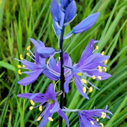
Love Dog Mountain! My dog loves it, too! It's a win-win with easy access and beautiful views ... which also makes Dog Mountain very popular ... especially during "Wild Flower Season" in the Spring. Parking Permits Year-round, visitors are required to pay for parking. Daily Northwest Forest Passes are $5 and can be paid onsite (cash only in park envelopes). Annual passes are $30 plus other agency passes are valid, too. Hiking Permits From March 31 - July 1, a "hiking" permit is required for each person. Permits are included in the $2 roundtrip Skamania County shuttle on high season weekends or 165 ($1.50) are available daily online. Check out the website for information on hiking permits. Hiking permits do not guarantee parking. Note people get tickets and towed for parking on Hwy 14. Trails There are two trailheads at the parking lot: * Dog Mountain Trail: 6.9 mile loop with 2,820 ft elevation gain * Augspurger Trail: 12.6 mile total with 4767 feet elevation gain Combine the two trails into a loop by taking the Dog-Augspurger Tie Trail (1.5 miles) on either the way up or the way down for a change of scenery. Both trails feature old-growth forests and rock fields with some panoramic views of the Columbia River. Of course, plan accordingly for gear, water, etc. depending on how much of the trail you choose to climb. The elevation gains are real and harder for me on the way down than on the way up. Dogs are welcome at Dog Mountain ... as long as they are on a leash and under parent control. My puppy never seems to wear out when we are there, but definitely passes out on the way home. For both of us, Dog Mountain Trail is a wonderful nature escape for some exercise with some breathtaking views sprinkled in along the way.

Most hikes in the Columbia Gorge offer picturesque views of cascading waterfalls or scenic overlooks, but If you're into flowers, Dog Mountain is the only hike you'll want to do! The entire SW face of the mountain above the treeline is FILLED with wildflowers from ~May to June. Here are some tips if you are thinking about going: - BRING LOTS OF WATER (minimum 1.5-2L per person) since there is no water at the trailhead, and wear sunscreen (the top 1/3 has little shade. - WATCH OUT for tons of POISON OAK on the lower 2/3 of the trail! If you don't know what it looks like, read the information board or ask someone. Merely touching the oily leaves can cause a severe rash that easily spreads. - Plan for the hike to last 3-6 hours depending on your speed and which trails you take (the main trail is 3mi to the top, or a shorter, steeper, and less pretty option will save you 0.3mi, or the Augspurger trail is 6.7mi to the top) - Bring a first aid kid for cuts, scrapes, bee stings, or sprained ankles. - It can be WINDY at the top, so if you plan to hang out up there, consider bringing a light jacket. - There is are 2 restrooms located at the trailhead. - Consider bringing hiking poles for extra balance coming down the steep slopes, or to make it easier going up. *NOTE: There is a $5 fee per car for parking. CAUTION: paying in cash is risky! I did so this weekend and still got a $55 parking ticket (I think the ranger pocketed the money), and since I paid in cash, I had no proof I put it in the envelope. Therefore I strongly recommend paying with a check, or better yet buying the $5 ONLINE day pass so you have proof you paid (or if you plan on doing a lot of hiking, buy the Northwest Forest Pass ($30) for a year's worth of unlimited parking at trailheads)

If you're looking for a spring time hike in the Columbia River Gorge, I recommend Google "Oregon wildflowers" and find out where the blooms are. The report this week took me to Dog Mountain. This is a strenuous hike with a phenomenal wildflower display on the top. I recommend hike the loop counterclockwise. Climb the steepest part first because it is rather difficult and slippery going down. It's about a 2 mile climb straight up--2,700 feet of elevation gain. Then, you have about a mile of walking the trail plastered with wildflowers on a ridge line above the Columbia River. Spectacular scenery for panoramic smart phone shots and close-ups using a digital SLR camera--many wild flower varieties. It is about 3 1/2 miles to the bottom. Overall 6 1/2 miles. Tough hike. Check out my photos. Note we parked in the lot (mile marker 53 on Route 14 east of Stevenson) on a Friday at 8:30 AM and the lot was nearly full. When we finished, vehicles were lined up along Rt 14. You will need a Northwest Forest Pass or Senior Pass.

I'd much prefer to call this trail "Doge Mountain": so steep very tired many wildflowers such views wowww The number of parking spots has drastically shrunk (75 spots vs. the 200 they had last year). A sign informed us the parking lot was already full, so we settled for shuttle service in the overflow parking area. The shuttle runs every 40 minutes and drops passengers off at the trail head. It's $1/person for each way. Bring exact change, the driver can't break your bills! *Important* - The last shuttle leaves the trail head at 4:15pm. It's a time constraint for hikers who arrive later in the day, or like to take it slow and enjoy the views (like myself). Still, I wouldn't advise missing the final bus. It's a looong way back to the shuttle parking lot. You'll still need to pay the customary $5 for your parking pass if you're blessed enough to find a spot at the trail head. This hike is rated difficult (and boy, they really mean it) and involves ~3,000 feet of elevation within 3 miles. The first 20 minutes were the toughest as my legs had to adapt to the shock of inclining so rapidly. You'll definitely want to rest at the switchbacks! For the most optimal trek up Le Doge, I'd recommend the following: *Good hiking shoes - To traverse the incline/rocks and avoid rolling your ankle. *Electrolytes - I drank an entire liter of water during the hike, but had to supplement with a Gatorade afterward to ward off the exhaustion. *Hiking Poles - This was IMMENSELY helpful with easing the strain to my muscles *Blanket - For sitting on the summit and basking in your gorgeous victory. *Camera - To gloat to your friends on Instagram (#dogmountain, bitches). The new parking situation is a bummer. Get there early so you won't have to sprint down from the summit. The grandeur of wildflowers are worth it despite the setbacks. I'd be happy to hike it doggy style again.

Absolutely a must-hike! The hike is hard as it is quite an incline all 3 miles uphill, but I promise you it is worth it. Go in the Spring time, late April to May and you will be rewarded with hillsides showered in wildflowers. If you don't like crowds go early! The parking lot fills fast. Consider a sunrise hike. Another perk to going early is avoiding the heat. Pros: wildflowers in the spring, phenomenal views of the gorge, great ass and calves Cons: gets crowded, discover pass required

Being from the PNW it's in my blood to love hiking and man is this hike worth it! My mom, friend and I took the shuttle bus ($2 per person) which was great because it also includes the price of a permit to hike on the weekends (only applicable April-June). It's a pretty steady upwards climb with minimal flat or downgrades on the way up. You're hiking through the forest for the majority of your trip, which is absolutely lovely. After about 2 miles you'll hit a "false summit" with some great views of the gorge. The next 1.8(ish) miles to the top is quite the trek but once you reach the real summit the wildflowers and views are absolutely stunning! Will definitely do again but earlier in April or May.

This hike is as brutal as it is beautiful. I think something like 3 people had to be airlifted from the summit over the summer. The 2800ft elevation gain is not for the faint of heart. Take it slow! Bring hiking poles and good shoes. Wildflower season is the star and is what makes this hike worth doing.


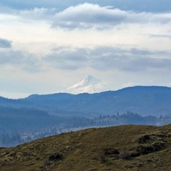
WOW what a GORGEOUS hike! Definitely very different scenery from Southern California and I am so glad I chose this hike! I will tell you though that this hike is quite steep and it is almost all incline to the summit. Not many switchbacks either. Just straight up climb. So if you don't like to sweat a lot, don't do this one cuz you will be sweating a lot! On the positive note, it's only around 3 miles to the summit so the huffin & puffin won't last too long. But trust me, the climb is definitely worth it because the reward up top is so breathtaking! I got to the trailhead at around 12:30pm or so on a Friday and this place was packed! There is a small parking lot at the trailhead and several places to park along the Lewis and Clark Hwy. No luck in finding parking at the lot so I ended up parking about 0.5 miles away from the trailhead. Not too bad, but it was a bit scary walking on the side of a highway when there are giant trucks flying right next to you & it's super windy. A Forest Pass or America the Beautiful pass is required to park, or you can pay $5 at the trailhead. Pit toilets are available by the trailhead. Enough of the parking & toilet mumbo jumbo (although important!). So it seems like there are several ways to get to Dog Mountain: #1) The really long route starting from the left side. I did hear from fellow hikers that this route has a more gentle grade (easier for the knees when going down). #2) Veering towards the right along the wooden post after going about 0.5 miles up the Dog Mountain trail. I guess this one is the more scenic and newer trail with a gentler climb. #3) Going along the left side of the wooden post after going 0.5 miles up Dog Mountain. This is the "old trail" and is shortest but steepest. I chose route #3 to go up and route #2 to come down Dog Mountain so I can enjoy a loop. I will tell you....yes, taking the "old trail" is steep. According to the Strava segment, the average grade from the trailhead to near the summit (dunno why the Strava segment ends slightly before the summit) is 21%. If you do not like to do a lot of steep climbing, this route may not be your best option. As long as you are somewhat fit and have some experience going uphill for several miles, it is definitely do-able if you pace yourself and rest when you need to. The terrain is not technical at all so your footing will be good throughout the climb. Really really well maintained trail. The first 2 miles or so is in the forest so you will be able to enjoy shade! Just don't wear winter tights like me when it's over 70 degrees....and don't forget your hat like me so there is nothing to catch your sweat...luckily I had a bandana in my backpack so I wrapped that around my head rambo style. Once you get out to the exposed section of the hike, you will be able to enjoy the fantastic view of the gorge and wild flowers!! There is a view point before the summit (I believe the viewpoint is called "puppy dog") where you can relax for a bit and take some pictures. From this point though, it was extremely windy and cold! Not sure if it is always like this, but it's a good idea to have a long sleeve in your backpack when doing this hike. Especially if you plan on staying at the summit for a while since it will feel extremely cold with sweaty clothing in the wind. It's just a short stretch from the viewpoint to the summit and you will be going along the ridge. Enjoy the beautiful wild flowers and gorgeous view of the gorge as you complete the final stretch and by the time you know it, you will be there!! The views at the summit is absolutely BEAUTIFUL and is a large enough area where many people were enjoying a snack or lunch. The same ole sandwich is going to taste so much better up here! Well, I didn't have a sandwich with me so I spent a few minutes taking pictures and talking to nearby hikers :P You can also see the top of Mt Hood from the summit! Coming down route #2 (the "scenic trail") felt slightly longer than route #3 but did feel less steep. There was a wooden bench at maybe around halfway down the scenic trail where you can enjoy some breathtaking views. I was expecting a little more scenery along this trail though since this is supposed to be the more scenic one. Still very beautiful with lots of green and shade! I took about 2.5 liters of water and ended up drinking 1.5 liters. Total round trip of about 6 miles (including the initial 0.5 miles from where I parked to the trailhead) with 2,756 ft of elevation gain. Took me around 2 hours 45 minutes with roughly 30 minutes for pictures and "I am out of breath" breaks. Highly highly recommend this hike! Hopefully I can take my wonderful dog with me next time so he can conquer Dog Mountain as well!

Dog Mountain has a bit of a notorious reputation in these parts. Most of my friends refer to it with an air of trepidation or exhaustion. "Oh man we hiked Dog Mountain yesterday. I'm wrecked today." or "Oh man we hiked Dog Mountain yesterday and there were way too many fucking people on the trail!" I guess after years of hearing that I had more than a few reservations about this hike. But now that I'm in much better shape than I have been for the past, say, ten years, and am training for a large summer climb, I figured it's time to try this dog out. In early April this trail is not crowded at all. We counted a sum total of one other car in the parking lot when we parked, and saw exactly six people (in one group) on the trail. I'm guessing this is because while it was 55 and drizzling at the trailhead, it was much worse up top. To get up top, you can choose one of three ways - the West trail, which is the longest and most mellow (relative) of the three. The East trail splits part way up, one route goes straight up (as someone wrote on the sign, it's the "Way of the Samurai"), and the other is more scenic (but still steeper than the Western route). We went up the West trail, which has a lot of great viewpoints on the way up. About 3 miles in, the Augsperger Mountain trail breaks off to the West (another 4.7 miles to Augsperger) and the Dog Mountain trail continues up another .9 miles to the spot where the East trail merges. Another .1 mile up is the summit. In early April, there aren't really any wildflowers in the alpine meadows at the top. Our view was a wall of gray, with high winds and sideways rain/sleet. Not the most hospitable place on the planet. There are a few windbreaks up top if you crawl into the trees, and we found a place to post up for a quick lunch. The cold and wet didn't allow us to stay long. As the clouds broke here and there, we caught a few views, and could tell that on a clear day the vistas must be stunning. We were grateful to have thought to bring rain pants, warm dry clothes, hats and waterproof shells. The full loop is something in the 7 mile range and the elevation gain is 2800 feet. This should not be your first hike of the year. Even the "mellow" route still gets you up 2800 feet, but the grade is just a little more merciful than the straight up way (which I still have yet to check out). The short, steep route is all trees until you get to the top, so while quicker and more punishing, it sounds like it's less entertaining. Bring water... lots of it. And at least a Kind bar or some type of snack/energy. And if you go early season, be prepared for the weather to be much harsher up top than it is at the trailhead. But that goes without saying for early spring hiking in Oregon. I will definitely come back for the flowers in May. I can tell that it will be epic on a nice day. As long as I can do it on a weekday. Crowds on trails just annoy the hell out of me.

")
1 year ago
2 months ago
This is one of the best hikes I've ever been on. It was extremely tough, but absolutely worth it. The wildflowers were breathtaking. Extremely windy and foggy at the top. It was rough but I would do it again! read more


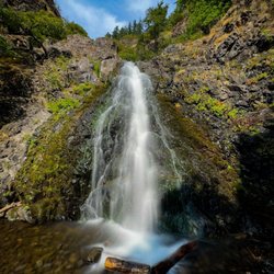
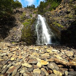
Dog mountain is one of the hardest hikes I've done when I first moved here. Now I find it a bit easier but on a day I want an ass kicker, this is still what I do. For an extra added workout I do the more difficult side coming up, and the other side coming down because I would like to have knees past 50. It has beautiful views and in June it has wild flowers, although I've yet to get up there during peak time for it still. I will say it can get really windy and cold at the top, so always bring an extra layer! But you probably won't need it on the way up because most of that's blocked out. While you are over there I also recommend Spirit Falls, which isn't too much further but is a beautiful waterfall that is truly special. I did both the last time I went and I always try to stop for a burger at Red Bluff Tavern on the way home. read more

Minus one star for things that have nothing to do with the natural beauty of this place. Parking, crowds... you know. But if you go off season, like we did, you can avoid those annoyances. No green meadows, no delicate emerging flowers, the hike in late fall is a snapshot of nature getting ready to settle down for the winter. But check out my photos. The sun coming through the clouds is picture perfect. We knew it would be cold, but we weren't expecting the frost on the ground. And when we crossed the high, open areas the wind cut through like an icy knife. But so what! We had the trail to ourselves and the parking lot was empty. It was a great workout, an incredible view, and a great day spent outside. read more


8 years ago
Love Dog Mountain! My dog loves it, too! It's a win-win with easy access and beautiful views ... which also makes Dog Mountain very popular ... especially during "Wild Flower Season" in the Spring. Parking Permits Year-round, visitors are required to pay for parking. Daily Northwest Forest Passes are $5 and can be paid onsite (cash only in park envelopes). Annual passes are $30 plus other agency passes are valid, too. Hiking Permits From March 31 - July 1, a "hiking" permit is required for each person. Permits are included in the $2 roundtrip Skamania County shuttle on high season weekends or 165 ($1.50) are available daily online. Check out the website for information on hiking permits. Hiking permits do not guarantee parking. Note people get tickets and towed for parking on Hwy 14. Trails There are two trailheads at the parking lot: * Dog Mountain Trail: 6.9 mile loop with 2,820 ft elevation gain * Augspurger Trail: 12.6 mile total with 4767 feet elevation gain Combine the two trails into a loop by taking the Dog-Augspurger Tie Trail (1.5 miles) on either the way up or the way down for a change of scenery. Both trails feature old-growth forests and rock fields with some panoramic views of the Columbia River. Of course, plan accordingly for gear, water, etc. depending on how much of the trail you choose to climb. The elevation gains are real and harder for me on the way down than on the way up. Dogs are welcome at Dog Mountain ... as long as they are on a leash and under parent control. My puppy never seems to wear out when we are there, but definitely passes out on the way home. For both of us, Dog Mountain Trail is a wonderful nature escape for some exercise with some breathtaking views sprinkled in along the way. read more


Most hikes in the Columbia Gorge offer picturesque views of cascading waterfalls or scenic overlooks, but If you're into flowers, Dog Mountain is the only hike you'll want to do! The entire SW face of the mountain above the treeline is FILLED with wildflowers from ~May to June. Here are some tips if you are thinking about going: - BRING LOTS OF WATER (minimum 1.5-2L per person) since there is no water at the trailhead, and wear sunscreen (the top 1/3 has little shade. - WATCH OUT for tons of POISON OAK on the lower 2/3 of the trail! If you don't know what it looks like, read the information board or ask someone. Merely touching the oily leaves can cause a severe rash that easily spreads. - Plan for the hike to last 3-6 hours depending on your speed and which trails you take (the main trail is 3mi to the top, or a shorter, steeper, and less pretty option will save you 0.3mi, or the Augspurger trail is 6.7mi to the top) - Bring a first aid kid for cuts, scrapes, bee stings, or sprained ankles. - It can be WINDY at the top, so if you plan to hang out up there, consider bringing a light jacket. - There is are 2 restrooms located at the trailhead. - Consider bringing hiking poles for extra balance coming down the steep slopes, or to make it easier going up. *NOTE: There is a $5 fee per car for parking. CAUTION: paying in cash is risky! I did so this weekend and still got a $55 parking ticket (I think the ranger pocketed the money), and since I paid in cash, I had no proof I put it in the envelope. Therefore I strongly recommend paying with a check, or better yet buying the $5 ONLINE day pass so you have proof you paid (or if you plan on doing a lot of hiking, buy the Northwest Forest Pass ($30) for a year's worth of unlimited parking at trailheads) read more


If you're looking for a spring time hike in the Columbia River Gorge, I recommend Google "Oregon wildflowers" and find out where the blooms are. The report this week took me to Dog Mountain. This is a strenuous hike with a phenomenal wildflower display on the top. I recommend hike the loop counterclockwise. Climb the steepest part first because it is rather difficult and slippery going down. It's about a 2 mile climb straight up--2,700 feet of elevation gain. Then, you have about a mile of walking the trail plastered with wildflowers on a ridge line above the Columbia River. Spectacular scenery for panoramic smart phone shots and close-ups using a digital SLR camera--many wild flower varieties. It is about 3 1/2 miles to the bottom. Overall 6 1/2 miles. Tough hike. Check out my photos. Note we parked in the lot (mile marker 53 on Route 14 east of Stevenson) on a Friday at 8:30 AM and the lot was nearly full. When we finished, vehicles were lined up along Rt 14. You will need a Northwest Forest Pass or Senior Pass. read more


3 years ago
I'd much prefer to call this trail "Doge Mountain": so steep very tired many wildflowers such views wowww The number of parking spots has drastically shrunk (75 spots vs. the 200 they had last year). A sign informed us the parking lot was already full, so we settled for shuttle service in the overflow parking area. The shuttle runs every 40 minutes and drops passengers off at the trail head. It's $1/person for each way. Bring exact change, the driver can't break your bills! *Important* - The last shuttle leaves the trail head at 4:15pm. It's a time constraint for hikers who arrive later in the day, or like to take it slow and enjoy the views (like myself). Still, I wouldn't advise missing the final bus. It's a looong way back to the shuttle parking lot. You'll still need to pay the customary $5 for your parking pass if you're blessed enough to find a spot at the trail head. This hike is rated difficult (and boy, they really mean it) and involves ~3,000 feet of elevation within 3 miles. The first 20 minutes were the toughest as my legs had to adapt to the shock of inclining so rapidly. You'll definitely want to rest at the switchbacks! For the most optimal trek up Le Doge, I'd recommend the following: *Good hiking shoes - To traverse the incline/rocks and avoid rolling your ankle. *Electrolytes - I drank an entire liter of water during the hike, but had to supplement with a Gatorade afterward to ward off the exhaustion. *Hiking Poles - This was IMMENSELY helpful with easing the strain to my muscles *Blanket - For sitting on the summit and basking in your gorgeous victory. *Camera - To gloat to your friends on Instagram (#dogmountain, bitches). The new parking situation is a bummer. Get there early so you won't have to sprint down from the summit. The grandeur of wildflowers are worth it despite the setbacks. I'd be happy to hike it doggy style again. read more


10 years ago
Absolutely a must-hike! The hike is hard as it is quite an incline all 3 miles uphill, but I promise you it is worth it. Go in the Spring time, late April to May and you will be rewarded with hillsides showered in wildflowers. If you don't like crowds go early! The parking lot fills fast. Consider a sunrise hike. Another perk to going early is avoiding the heat. Pros: wildflowers in the spring, phenomenal views of the gorge, great ass and calves Cons: gets crowded, discover pass required read more


Being from the PNW it's in my blood to love hiking and man is this hike worth it! My mom, friend and I took the shuttle bus ($2 per person) which was great because it also includes the price of a permit to hike on the weekends (only applicable April-June). It's a pretty steady upwards climb with minimal flat or downgrades on the way up. You're hiking through the forest for the majority of your trip, which is absolutely lovely. After about 2 miles you'll hit a "false summit" with some great views of the gorge. The next 1.8(ish) miles to the top is quite the trek but once you reach the real summit the wildflowers and views are absolutely stunning! Will definitely do again but earlier in April or May. read more


This hike is as brutal as it is beautiful. I think something like 3 people had to be airlifted from the summit over the summer. The 2800ft elevation gain is not for the faint of heart. Take it slow! Bring hiking poles and good shoes. Wildflower season is the star and is what makes this hike worth doing. read more


8 years ago
10 years ago
Steep-Steep-Steep. Great view totally worth it!! Sore everywhere!! Need day pass or NW pass- REI Not a lot of parking get there early. Its windy on top and chilly, layer up. Only a restroom at parking site. Bring lots of water. Fun day! Takes 4 to 5 hours for somewhat experienced hikers read more

9 years ago
WOW what a GORGEOUS hike! Definitely very different scenery from Southern California and I am so glad I chose this hike! I will tell you though that this hike is quite steep and it is almost all incline to the summit. Not many switchbacks either. Just straight up climb. So if you don't like to sweat a lot, don't do this one cuz you will be sweating a lot! On the positive note, it's only around 3 miles to the summit so the huffin & puffin won't last too long. But trust me, the climb is definitely worth it because the reward up top is so breathtaking! I got to the trailhead at around 12:30pm or so on a Friday and this place was packed! There is a small parking lot at the trailhead and several places to park along the Lewis and Clark Hwy. No luck in finding parking at the lot so I ended up parking about 0.5 miles away from the trailhead. Not too bad, but it was a bit scary walking on the side of a highway when there are giant trucks flying right next to you & it's super windy. A Forest Pass or America the Beautiful pass is required to park, or you can pay $5 at the trailhead. Pit toilets are available by the trailhead. Enough of the parking & toilet mumbo jumbo (although important!). So it seems like there are several ways to get to Dog Mountain: #1) The really long route starting from the left side. I did hear from fellow hikers that this route has a more gentle grade (easier for the knees when going down). #2) Veering towards the right along the wooden post after going about 0.5 miles up the Dog Mountain trail. I guess this one is the more scenic and newer trail with a gentler climb. #3) Going along the left side of the wooden post after going 0.5 miles up Dog Mountain. This is the "old trail" and is shortest but steepest. I chose route #3 to go up and route #2 to come down Dog Mountain so I can enjoy a loop. I will tell you....yes, taking the "old trail" is steep. According to the Strava segment, the average grade from the trailhead to near the summit (dunno why the Strava segment ends slightly before the summit) is 21%. If you do not like to do a lot of steep climbing, this route may not be your best option. As long as you are somewhat fit and have some experience going uphill for several miles, it is definitely do-able if you pace yourself and rest when you need to. The terrain is not technical at all so your footing will be good throughout the climb. Really really well maintained trail. The first 2 miles or so is in the forest so you will be able to enjoy shade! Just don't wear winter tights like me when it's over 70 degrees....and don't forget your hat like me so there is nothing to catch your sweat...luckily I had a bandana in my backpack so I wrapped that around my head rambo style. Once you get out to the exposed section of the hike, you will be able to enjoy the fantastic view of the gorge and wild flowers!! There is a view point before the summit (I believe the viewpoint is called "puppy dog") where you can relax for a bit and take some pictures. From this point though, it was extremely windy and cold! Not sure if it is always like this, but it's a good idea to have a long sleeve in your backpack when doing this hike. Especially if you plan on staying at the summit for a while since it will feel extremely cold with sweaty clothing in the wind. It's just a short stretch from the viewpoint to the summit and you will be going along the ridge. Enjoy the beautiful wild flowers and gorgeous view of the gorge as you complete the final stretch and by the time you know it, you will be there!! The views at the summit is absolutely BEAUTIFUL and is a large enough area where many people were enjoying a snack or lunch. The same ole sandwich is going to taste so much better up here! Well, I didn't have a sandwich with me so I spent a few minutes taking pictures and talking to nearby hikers :P You can also see the top of Mt Hood from the summit! Coming down route #2 (the "scenic trail") felt slightly longer than route #3 but did feel less steep. There was a wooden bench at maybe around halfway down the scenic trail where you can enjoy some breathtaking views. I was expecting a little more scenery along this trail though since this is supposed to be the more scenic one. Still very beautiful with lots of green and shade! I took about 2.5 liters of water and ended up drinking 1.5 liters. Total round trip of about 6 miles (including the initial 0.5 miles from where I parked to the trailhead) with 2,756 ft of elevation gain. Took me around 2 hours 45 minutes with roughly 30 minutes for pictures and "I am out of breath" breaks. Highly highly recommend this hike! Hopefully I can take my wonderful dog with me next time so he can conquer Dog Mountain as well! read more


Dog Mountain has a bit of a notorious reputation in these parts. Most of my friends refer to it with an air of trepidation or exhaustion. "Oh man we hiked Dog Mountain yesterday. I'm wrecked today." or "Oh man we hiked Dog Mountain yesterday and there were way too many fucking people on the trail!" I guess after years of hearing that I had more than a few reservations about this hike. But now that I'm in much better shape than I have been for the past, say, ten years, and am training for a large summer climb, I figured it's time to try this dog out. In early April this trail is not crowded at all. We counted a sum total of one other car in the parking lot when we parked, and saw exactly six people (in one group) on the trail. I'm guessing this is because while it was 55 and drizzling at the trailhead, it was much worse up top. To get up top, you can choose one of three ways - the West trail, which is the longest and most mellow (relative) of the three. The East trail splits part way up, one route goes straight up (as someone wrote on the sign, it's the "Way of the Samurai"), and the other is more scenic (but still steeper than the Western route). We went up the West trail, which has a lot of great viewpoints on the way up. About 3 miles in, the Augsperger Mountain trail breaks off to the West (another 4.7 miles to Augsperger) and the Dog Mountain trail continues up another .9 miles to the spot where the East trail merges. Another .1 mile up is the summit. In early April, there aren't really any wildflowers in the alpine meadows at the top. Our view was a wall of gray, with high winds and sideways rain/sleet. Not the most hospitable place on the planet. There are a few windbreaks up top if you crawl into the trees, and we found a place to post up for a quick lunch. The cold and wet didn't allow us to stay long. As the clouds broke here and there, we caught a few views, and could tell that on a clear day the vistas must be stunning. We were grateful to have thought to bring rain pants, warm dry clothes, hats and waterproof shells. The full loop is something in the 7 mile range and the elevation gain is 2800 feet. This should not be your first hike of the year. Even the "mellow" route still gets you up 2800 feet, but the grade is just a little more merciful than the straight up way (which I still have yet to check out). The short, steep route is all trees until you get to the top, so while quicker and more punishing, it sounds like it's less entertaining. Bring water... lots of it. And at least a Kind bar or some type of snack/energy. And if you go early season, be prepared for the weather to be much harsher up top than it is at the trailhead. But that goes without saying for early spring hiking in Oregon. I will definitely come back for the flowers in May. I can tell that it will be epic on a nice day. As long as I can do it on a weekday. Crowds on trails just annoy the hell out of me. read more


12 years ago
I went here 2 days ago and I'm still in pain....It hurts so good! Dog mountain trailhead is very easy to find, just off of milepost 53 along Highway 14. Loop is about 7 miles, that's 3.8 miles with 2800 elevation gain. It can be very windy at the top. read more


12 years ago
Oh my! This hike kicked my butt lol I was never a complainer when it came to hiking until now. 1/4 of the way up and I was panting out of breath, if it wasn't for my friends and family, I would have went back down. But boy oh boy would that have been a mistake. This was the most beautiful view I have ever seen in my life. Just amazing, literally breathtaking. :) 4 days later and I'm still sore. It feels amazing definitely a must go, especially towards the end of May when the flowers are in bloom. It's an unforgettable sight, and pics don't do the justice of how it really looks in person. It's seriously the most amazing, and wonderful view/hike I've ever been on :) read more
 - Hiking Near Me - White Salmon, Washington")


 - Hiking Near Me - White Salmon, Washington")
 in between scenic views of the hike - Hiking Near Me - White Salmon, Washington")
15 years ago
11 years ago
This is a strenuous hike and one of the most beautiful the gorge has to offer. Best during spring when the blooms start. Very picturesque. read more

11 years ago
12 years ago
A great trail. The hike can be tough at certain areas, but bring adequate water and supplies and you'll be fine. If a person is out of shape take plenty of breaks. The trail is totally do-able though. The summit has a spectacular view. It's a great place for lunch and makes the trek worth it. read more


14 years ago
Did this hike the other day, had been meaning to do it for quite sometime I had heard good things about it. Trailhead and parking lot is just east of Stevenson WA off Highway 14. Parking lot was way busy with probably 20 cars at least, its $5 to park there. There are a couple ways you can start the trail, we chose the tougher route which starts off with several switchbacks going up the side of the mountain. There are a few areas with lookouts on the way up looking out over the Columbia river gorge. From the top of Dog Mountain you can see the top of Mt Hood. I was pretty dissapointed in the hike overall, I will go back earlier in the spring next year and do it again I've heard thats the time to go when all the flowers are out. On the plus side though it was a decent workout, a bit tougher of a workout than most any other hike you could do in the area. read more

10 years ago
12 years ago
11 years ago
11 years ago
9 years ago
More info about Dog Mountain Trail
State Rte 14
White Salmon, WA 98672
Directions
Visit Website
https://www.fs.usda.gov/recarea/crgnsa/recarea/?recid=29900
Hours
Indoor Amenities
Outdoor Amenities
Ask the Community - Dog Mountain Trail
Review Highlights - Dog Mountain Trail


Why does Yelp recommend reviews?
3 reviews that are not currently recommended
The reviews below are not factored into the business's overall star rating.
6 years ago
11 years ago
11 years ago
Dog Mountain Trail - hiking - Updated July 2026
Best of White Salmon
People found Dog Mountain Trail by searching for…
Hiking Trails With Waterfalls in White Salmon, WA
Things to Do in White Salmon, WA
Scenic View in White Salmon, WA
Dog Friendly Hiking Trails in White Salmon, WA
Scenic Overlook in White Salmon, WA
Lookout Points in White Salmon, WA
Sunrise View in White Salmon, WA
Secret Spots in White Salmon, WA
Dog Friendly Parks in White Salmon, WA
Photo Spots in White Salmon, WA
Secluded Spots in White Salmon, WA
Sunset View in White Salmon, WA
Off Road Trails in White Salmon, WA
Sunrise Hike in White Salmon, WA
Running Trails in White Salmon, WA
Things to Do on a Rainy Day in White Salmon, WA
Places to Take Pictures in White Salmon, WA
Easy Hikes in White Salmon, WA
Playgrounds in White Salmon, WA
Waterfalls and Swimming Holes in White Salmon, WA
Trending Searches in White Salmon, WA
Blueberry Picking near Dog Mountain Trail
Boat Tours near Dog Mountain Trail
Cliff Jumping near Dog Mountain Trail
Day Trips near Dog Mountain Trail
Dog Swimming near Dog Mountain Trail
Jet Ski Rental near Dog Mountain Trail
Kayak Rental near Dog Mountain Trail
Outdoor Activities near Dog Mountain Trail
Peach Picking near Dog Mountain Trail
Public Shower near Dog Mountain Trail
Rainy Day Activities near Dog Mountain Trail
Scenic Overlook near Dog Mountain Trail
Surf Shop near Dog Mountain Trail
Swimming Holes near Dog Mountain Trail
Swimming Lakes near Dog Mountain Trail
Things To Do On A Rainy Day near Dog Mountain Trail
Tubing near Dog Mountain Trail
U Pick Farms near Dog Mountain Trail
View Points near Dog Mountain Trail
Browse Articles
Browse Nearby
Browse Brands
Related Searches in White Salmon, WA
Affordable Kayak Rental Services in White Salmon, Washington
Best Dog Hiking Trails Around White Salmon, Washington
Best Fishing Locations and Guides in White Salmon, Washington
Best Places for Horseback Riding in White Salmon, Washington
Discover Dog Friendly Trails to Explore in White Salmon, Washington
Discover a Hiking Trail in White Salmon, Washington
Discover the Best Night Hike Trails in White Salmon, Washington
Dog-Friendly Hikes With Dogs in White Salmon, Washington
Enjoy Camping Adventures Around White Salmon, Washington
Enjoy Kayaking Adventures in White Salmon, Washington
Enjoy Off Leash Dog Hikes in White Salmon, Washington
Enjoy Tent Camping Spots Around White Salmon, Washington
Enjoy a Beautiful Waterfall Hike in White Salmon, Washington
Enjoy the Best Walking Trails in White Salmon, Washington
Experience Thrilling White Water Rafting in White Salmon, Washington
Explore Beautiful Parks and Green Spaces in White Salmon, Washington
Explore Easy Hikes Perfect for All in White Salmon, Washington
Explore Fun Activities to Do in White Salmon, Washington
Explore Popular Campgrounds Near White Salmon, Washington
Explore Scenic Lakes to Visit in White Salmon, Washington
Explore Top Dog Parks in White Salmon, Washington Near You
Explore the Best Beach Spots in White Salmon, Washington
Explore the Best Swimming Holes Around White Salmon, Washington
Family Friendly Hiking With Kids in White Salmon, Washington
Find Beautiful Views in White Salmon, Washington
Find Popular Ziplining Spots Around White Salmon, Washington
Find Top-Rated Waterfalls in White Salmon, Washington Now
Find the Best Parks for Picnics in White Salmon, Washington
Find the Best Playgrounds to Visit in White Salmon, Washington
Hiking Trails With Waterfalls in White Salmon, Washington
Off Leash Dog Hiking Trails in White Salmon, Washington
Perfect Spots to Watch Sunset in White Salmon, Washington
Popular Fishing Spots to Explore in White Salmon, Washington
Popular Kids Activities in White Salmon, Washington
Popular Outdoor Activities to Try in White Salmon, Washington
Popular Picnic Spots to Visit in White Salmon, Washington
Safe and Fun Parks for Kids in White Salmon, Washington
Tennis Courts and Clubs Near White Salmon, Washington
Top Fishing Charter Experiences in White Salmon, Washington
Top Hiking Trails to Explore in White Salmon, Washington
Top Playgrounds for Kids to Enjoy in White Salmon, Washington
Top Running Trails to Explore in White Salmon, Washington
Top Swimming Lakes to Enjoy in White Salmon, Washington
Top Swimming Spots and Pools in White Salmon, Washington
Top-Rated Camping Sites in White Salmon, Washington
Walk Dog Friendly Hiking Trails in White Salmon, Washington
Where to Catch the Best Sunrise View in White Salmon, Washington


