Little Finland Photos


 - Hiking Near Me")
You might also consider
More like Little Finland
Recommended Reviews - Little Finland
Start your review...

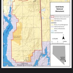
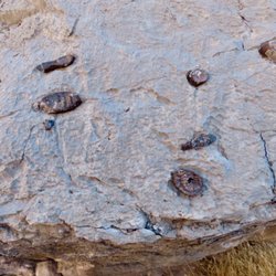
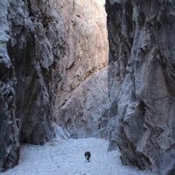
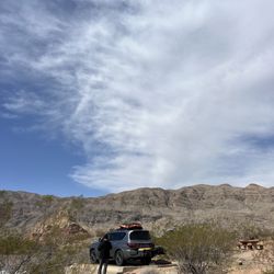
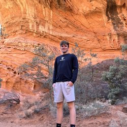
I originally found out about this place from a site I follow on Facebook, Roadtrippers (awesome site, by the way) and I had one of those, "what the" moments finding out this place is a quick 90-120 minutes away from where I live. A quick drive up I-15N and exit #112, Bunkerville (this is just south of Mesquite), and follow the signs to Whitney Pockets. You will the infamous Bundy Ranch area. The road is paved until you hit the Whitney Pockets area, then a HCV vehicle is needed. I did see a passenger car attempting to drive thru here, I guess it could be done, but it's not a place I would want to get stuck. Once you hit the trailhead area, you'll see a large red sandstone wall in the middle of nowhere. This is where you park. There are some really cool, preserved petroglyphs on the wall here. Make sure you look up to see them, they're kind of high up. From there it's a walk on a dirt road and dry wash to the area. There aren't any marking or cairns for the turnoffs to hit the trail to Little Finland, so it's best to go with someone who has been before, or do your research. The area is pretty darn cool. The sandstone rock formations get the name from wind and erosion that has made the made the rock appear to have fins. The area is really delicate, so be careful not to ruin what nature and time has created. Once you're in Litle Finland, there are more petroglyphs as well as some running water through the area. The minerals in the water made the water and rock turn colors, the entire area made me think I was on Mars. If you've ever been to Goblin Valley State Park, this is a miniature version of it. It's a pretty cool day trip. read more


Little Finland (aka Hobgoblin's Playground and Devil's Fire) is a magical place where wind and water have sculpted red sandstone rock into fantastical shapes. I just explored this unique area with my boyfriend and a group of hikers today. Located in a remote portion of the remote Gold Butte region of southeastern Nevada ( south of Mesquite), Little Finland was a challenge to get to...about an hour on bumpy unpaved road but well worth the effort. The rocks there are very ornate and delicate, so please becareful. If you are driving north on I-15 from Las Vegas, exit at #112 (Riverside / Bunkerville), turn right and go 3 miles to cross the Virgin River. Make a right turn at the next road (Gold Butte Road), drive twenty miles on loud bumpy pavement, becareful of the free range cows, the hit the graded dirt road for four more miles. Finally, turn right at the sign that indicates Red Bluff Springs and drive four more miles on a sandy uneven dirt road that requires a high clearance vehicle. This is your day long adventure, make sure you go prepared. Bring warm clothing, gloves, hat, lots of water, a snack or lunch, sturdy boots and most of all bring your camera! The most fascinating thing about this place is the fantasyland of shapes--almost every rock appears to be an animal, face, or mythical creature. It is mixed in with the intricate red rock sculptures are fields of virtually white sandstone with sinuous waves, remnants of ancient sand dunes. In other places, the rock is covered with a thin white crust--salt that has crystallized out of groundwater running through the rock. Go see it to believe it! read more


More info about Little Finland
You might also consider


Little Finland - hiking - Updated May 2026
Best of Bunkerville
Browse Brands
Related Searches in Bunkerville, NV
Best Fishing Locations and Guides in Bunkerville, Nevada
Best Fun Things to Do in Bunkerville, Nevada
Best Places for Horseback Riding in Bunkerville, Nevada
Check Out Off Road Trails in Bunkerville, Nevada
Discover Dog Friendly Trails to Explore in Bunkerville, Nevada
Discover Scenic Mountain Bike Trails Near Bunkerville, Nevada
Discover Top Boat Tours in Bunkerville, Nevada for All Ages
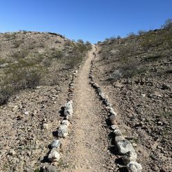
Discover a Hiking Trail in Bunkerville, Nevada
Discover the Best Night Hike Trails in Bunkerville, Nevada
Dog-Friendly Hikes With Dogs in Bunkerville, Nevada
Enjoy Camping Adventures Around Bunkerville, Nevada
Enjoy Tent Camping Spots Around Bunkerville, Nevada
Enjoy the Best Walking Trails in Bunkerville, Nevada
Explore Beautiful Botanical Gardens in Bunkerville, Nevada
Explore Beautiful Parks and Green Spaces in Bunkerville, Nevada
Explore Bike Rentals Throughout Bunkerville, Nevada
Explore Easy Hikes Perfect for All in Bunkerville, Nevada
Explore Free Things to Do Around Bunkerville, Nevada
Explore Fun Activities to Do in Bunkerville, Nevada
Explore Popular Campgrounds Near Bunkerville, Nevada
Explore Popular RV Parks Around Bunkerville, Nevada
Explore Scenic Lakes to Visit in Bunkerville, Nevada
Explore Top Dog Parks in Bunkerville, Nevada Near You
Explore Top Water Parks in Bunkerville, Nevada Today
Explore the Best Boating Spots in Bunkerville, Nevada
Find Beautiful Views in Bunkerville, Nevada
Find Fun Kids Activities Outdoor in Bunkerville, Nevada
Find Parks and Recreation Activities in Bunkerville, Nevada
Find Popular Ziplining Spots Around Bunkerville, Nevada
Find Top Skate Parks in Bunkerville, Nevada for All Skill Levels
Find Top-Rated Disc Golf in Bunkerville, Nevada
Find the Best Playgrounds to Visit in Bunkerville, Nevada
Have Fun at a Splash Pad in Bunkerville, Nevada
Hiking Trails With Waterfalls in Bunkerville, Nevada
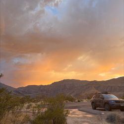
Perfect Spots to Watch Sunset in Bunkerville, Nevada
Plan a Scenic Drive Route Near Bunkerville, Nevada
Popular Fishing Spots to Explore in Bunkerville, Nevada
Popular Kids Activities in Bunkerville, Nevada
Popular Things to Do in Bunkerville, Nevada
Relax at Natural Hot Springs Near Bunkerville, Nevada
Safe River Swimming Areas in Bunkerville, Nevada
Safe and Fun Parks for Kids in Bunkerville, Nevada
Top Climbing Spots and Gyms in Bunkerville, Nevada
Top Paddleboarding Activities in Bunkerville, Nevada
Top Playgrounds for Kids to Enjoy in Bunkerville, Nevada
Top Running Trails to Explore in Bunkerville, Nevada
Top Swimming Lakes to Enjoy in Bunkerville, Nevada
Top Swimming Spots and Pools in Bunkerville, Nevada
People found Little Finland by searching for…
Things to Do in Bunkerville, Nevada
Gold Panning in Bunkerville, Nevada
Sand Dunes in Bunkerville, Nevada
Hiking Trails in Bunkerville, Nevada
Waterfalls and Swimming Holes in Bunkerville, Nevada
State Parks in Bunkerville, Nevada
Swimming Lakes in Bunkerville, Nevada
Playgrounds in Bunkerville, Nevada
Sunbathing in Bunkerville, Nevada
Fishing Spots in Bunkerville, Nevada
Full Moon Hike in Bunkerville, Nevada
Walking Trails in Bunkerville, Nevada
Rock Quarry in Bunkerville, Nevada
Scenic Views in Bunkerville, Nevada
Off Road Trails in Bunkerville, Nevada
Running Trails in Bunkerville, Nevada
Places to Take Pictures in Bunkerville, Nevada
Secret Spots in Bunkerville, Nevada
Redwood Trees in Bunkerville, Nevada
Trending Searches in Bunkerville, NV
Botanical Gardens near Little Finland
Bounce House Rentals near Little Finland
Campgrounds near Little Finland
Flower Shop near Little Finland
Garage Sales near Little Finland
Mountain Bike Trails near Little Finland
Nurseries & Gardening near Little Finland
Outdoor Furniture Stores near Little Finland
Party Equipment Rentals near Little Finland
Picnic Areas near Little Finland
Places To Take Pictures near Little Finland
Plant Nursery near Little Finland
Running Trails near Little Finland
Scenic Drive near Little Finland