White Domes Photos


More like White Domes
Recommended Reviews - White Domes
Start your review...

Reviews With Photos

This was a fun short hike. We hiked about a mile there and back without doing the loop. The rock formation was neat, and we saw some wild life too. My biggest complaint is the complete lack of signage. We had fun climbing and exploring but we're unsure if we were on the right path although we were happy to have some help from another hike.

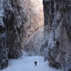
The White Domes Trail (1.1 miles loop) was the highlight of our visit to the Valley of Fire (VOF) State Park. The halfway point is where you'll find a couple of gems: a portion of a hacienda built in 1965 for a movie set called "The Professionals" - and - the slot canyon known as "The Narrows" at VOF (just missing the river!). The official start of the trailhead is at the end of the White Domes Road. Drive until you reach the dead end, which is also the parking lot and picnic area for White Domes. Walk towards the informational trail boards to begin the adventure through the beach sand. We thought about turning back in this section, because walking through sand with the sun beating down on us was a bit challenging. So glad the hikers alongside us gave us a pep talk, so we continued on. LOL. Happy to report we completed the trail (it was not all beach sand afterall) and we were able to snap some awesome photos. We spent about 40 minutes on the trail. A couple of observations: 1) Saw a dog and his human climbing "up" the trail and thought nothing of it until we reached the end of the trail. We realized he was going the "wrong" way so that explains why the poor dog was panting so hard and why the human was gasping for air while climbing up through the rocks. Start from the top of the trailhead and everything will be fine. Not much panting guaranteed! 2) Don't forget to look back at the trail and look up at the sky as you traverse, especially when in the slot canyon, to ensure you soak in all perspectives and overall beauty of the brilliant striations in the sandstone. Wear appropriate shoes. Bring water. Wear a hat. Time your potty breaks right. Watch your step, or else the reptiles will get ya! :-) A must visit! We had fun!!

White Domes is a must have trail if you visit Valley of Fire. I would suggest go from left entrance because sharp drop then gradually gain the elevation to original point. This way is better and less effort. It is about 1.25 miles round trip. The elevation difference is about 180 feet. It is not wheel chair accessible. The trail is at the end of the White Dome road. It is about 6.7 miles from the visitor center. You will see the loop ramp there will be the trail head. The view with large dome rock it the symbol of the awesome. Then you go down to the river bed and you will see a lot wind and water carve path way. Then you walk into a slot canyons. After the slot canyon, it is multicolored rock formations. The the picnic rock arch. Following a straight away trail back to parking lot. The trail is easy to handle. Along the trail was well mark and you will not get lost. It is definitely a must see when you visit the Valley of Fire.


White Domes is a must visit when you come to Valley of Fire. There's a picnic area and restrooms near the parking area before the beginning of the trail. The trial loop is 1.25 miles long, the beginning is a sandy trail that eventually becomes rocky/gravel like. The mini slot canyon half way through the trial is a nice spot to take some cool pictures and the back end of the trail that leads back to the parking area has some great views with the mountains in the back ground. Son I real shaded areas on the trial so make sure to bring a hat and some sunscreen, and also keep an eye out for actual trail sign markers. One of the signs near the back end of the trail wasn't up and we wondered out onto Prospect trail for half a mile until we realized we were way over the distance the hike should be.

Worth the price of admission which is $25. Worth the hike in the sizzling blazing heat. This was such an experience worth doing. White Domes is a hiking stop within The Valley of Fire, about a good Hour drive from the Toll stop. The beginning of the trail was not what I expected. It starts of SANDY and works up to A LOT of rocks....so be prepared. I would recommend wearing a hat, wearing sunscreen, wearing proper hiking shoes, and definitely bringing water.

Always worth the price of admission. It is best to visit early morning as the heat is still bearable and you are more able to complete the hikes. Lots of open air space to take amazing pictures. Professional or not. Remember to bring sunscreen, a hat and sunglasses as well as comfy shoes as you will do a lot of walking. Come here to enjoy all of nature's beauty. Remember to pack it in and pack it out! If you plan on brining food and drink for a picnic, be sure to place your trash in the designated bins. Keep nature clean. Respect the rocks and don't destroy it by writing or defacing it. I plan on visiting again when in Vegas... You should too! A short drive from the strip - definitely worth the visit.

Love this amazing hike. VoF has so many cool destinations but this is my favorite so far. The hike is not too long, however some elevation gain. But the views are amazing and reward. You get to walk through a small slot canyon with great photo opportunities and an expansive views of valley as you come out of the slot canyon. Make sure to plan and ahead and visit early and dont do it the the summer. It can get extremely hot and there are not a lot of shades.

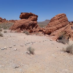
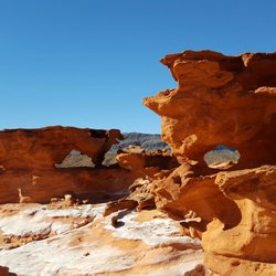
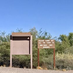
The White Domes are beautiful to look at and a great place to stop inside the Valley of Fire State Park. These large white formations are quite a change from the red rock that makes up much of the park's surrounding area. This a great place to stop since there is a large paved parking area, lots of visitor information on the signs, bathroom facilities, and a covered picnic area with grills. We stopped to enjoy our lunch in the picnic area and even though it was about 112 degrees in a July, there was a nice breeze blowing through the open area. There is also a 1 mike hike here; but we skipped this one.

This is my favorite trail at Valley of Fire, and probably the most challenging- that's not saying much though, because the distance is barely over a mile, and it's a loop that takes you right back where you started. The terrain is sandy and at times rocky, so use caution. I generally wear hiking boots but they aren't really necessary on this trail. I would say anyone can do this trail but maybe use your best judgement with small kids: we took a 5 year old out with us last time and needed to keep a close eye on her at some points due to the rocky portions. Follow Norm's tip to extend this trail and explore the area beyond the wash!

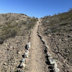
A lovely, easy one mile trail to explore some of the beautiful scenery that can't be viewed just by driving through Valley of Fire. One of the more popular hiking spots in the park you may find parking to be a bit tight at the start of this trail. Since the trail is short it seemed like parking spot turnover occurs frequently though. The trail starts with a short uphill walk in the sand. The sand is really soft and feels nice. Then the trail turns to rock steps that go downhill and are still sandy. The short slot canyon was my favorite part and provided some lovely shade. The trail back is more rocky, but mostly flat. There wasn't anything strenuous about the hike and it was more of an enjoyable stroll. There are several trail markers so it's easy to follow the loop. Even though we saw a lot of cars in the park we didn't find this trail to be crowded. It was amazingly quiet and serene along the trail.

This is a 1.2 mile loop hike in the Valley of Fire, the first state park in Nevada (1935). Anyone can do this hike, and you could even wear sneakers--with care. The hike starts at the White Domes parking area. The road to the White Domes area starts near the Visitor Center and is clearly marked. Read the interpretive markers in the parking area. This is the area where several movies were filmed, but most specifically, the 1966 film, The Professionals. Part of the movie set remains near the parking area - some concrete pillars and wooden beams. There is more along the trail. The trail is well marked. From the parking lot, hike south. You will go through some very fine sand, so if you wear sneakers, be prepared to have them get a lot of sand inside before you're done. The hike goes up a hill into a narrow canyon area. At the top of the hill, you get an extraordinary view of this section of the Valley of Fire. Start down the rocks, stepping carefully as you go because your boots will take the fine sand with you and the rocks can be slippery. At the bottom of this area, you come to an open area where some of the movie set remains. This was the last movie filmed here before regulations went into effect that all movie making scenery had to be removed after filming (leave no trace). The movie set is not awfully impressive. It's history and who was here starring in the film (Claudia Cardinale, Burt Lancaster, Lee Marvin, and Jack Palance to name a few), are what make me like seeing it. I got the film from Netflix so I could see the set and VOF in the film. From the movie set, you have a short walk until you come to a wash. The trail goes right and you soon come to a short slot canyon that is very beautiful. This slot canyon was the scene of several gunfights and horse chases in the movie. Once through the canyon, the trail goes to the right again, and you start to make the loop back to the car. The trail passes on the west side of the ridge near the parking lot and you pass the cars. Near the end, the trail makes a U shaped turn, and you come back along the roadside to get back to the parking lot. This hike can be combined with Mouse's Tank and do two things at Valley of Fire in one trip. Note: To make this hike a bit longer, when you get to the wash beyond the movie set, you can turn left and explore that direction for awhile. It eventually comes out on the road. You can also do some boulder hopping on the sandstone south of the wash. In any case, get back to the wash and follow the loop back. Happy hiking!

This was one of the hikes I did today with a friend of mine at the Valley of Fire State Park. It's great for beginners. There are lots of climbing and scrambling on this trail and lots of photo opportunities. White Domes Day Use Area has picnic tables and bathrooms. If you are to hike only one trail in Valley of Fire this should be a good one. Such amazing colors, and rock formations everywhere you look even a slot canyon. There are many small arches along the entire trail. Oh there is also a sign that says this area was used to film a Star Trek movie. You can make this hike very easy or challenging by playing on the rocks and scrambling. It's fantastic and breathtaking in my opinion. It was a cold day around 46 °F high and it's much better going during winter then between May-September.

5 months ago
A truly fantastic hike with changing scenic views along the way. The trail is also ever changing, from sand, to packed dirt, to rocky/gravel, and steep stone steps. I personally recommend doing this trail counterclockwise. We're in our 30s, but my husband has bad knees and I get lower back pain; we find that the steep stone steps are far easier to go up than down. Having a walking stick while climbing the steps is also helpful. You will see some incredible things while hiking this trail. The texture on the rocks, the multitude of colors, windows, slot canyons, a portion of an old movie set, and some grand majestic views. Being an avid hiker and having hiked 80% of the trails within Valley of Fire, I'd consider this to be a moderate hiking trail. Note: There is a small covered picnic area with 4 tables as well as 4 gender neutral vault toilets near the start of this trail and next to the parking lot. read more


Amazing hike with beautiful scenery and moderate level. Starting out into the hike you have to walk through some sand which doesn't sound hard but it's actually strenuous on your body. Follow that down through some rocky man-made type rock stairs past an old movie set where you feel like you're in Star Wars Then follow that to the slot canyon. The slot Canyon is my favorite part of the hike. Very beautiful and unique. We just took our time going through the hike as we had some friends with us who were inexperienced hikers and we wanted to make sure everyone got through safely. I could've gone onto a few more hikes that day, but they were pretty tired. I will definitely go back here again. This was my second or third time here. read more


This review is for any plus sized people, people with older dogs, people with mobility issues, etc. As most people do, we researched this entire park and each trail before our trip. Every review and snippet we came across talked about how this was an "easy, 1 mile loop" which sounded perfect for a chubby, middle aged couple with a senior dog. Unfortunately, that is not the truth. We drove up to the parking area to find 3 buses full of people and a crowded parking lot. There was a covered picnic area full of people and multiple restrooms at the trailhead. The elderly couples that arrived just before us headed off while we stopped to use the restrooms. We made sure to have our hats on and brought plenty of water and started off ourselves. After a sandy and slightly elevated uphill stroll, we stopped to see the elderly couples heading down the next section of the path which is a very steep rocky decline. A man with his cane that was with his granddaughter, ended up turning around and heading back near the top of the descent. Another older gentleman was trying to help his friend and they slipped. We stayed behind them for a few minutes being careful ourselves and ultimately passed around. They never made it to the end but they were in fine health other than their advanced age and I was quite angry by the time we reached the bottom at how unsafe that entire section had been. Our elderly dog had slipped twice before we ended up carrying her (which made it all the more dangerous for us I might add) and my husband also scraped his leg and slipped himself. They should not call this an "easy" trail. The only level terrain you will encounter is on the very short section of slot canyon, which is lovely but for me personally was not worth the treacherous journey. The movie ruins are neat, but blink and you will miss them. If I had to do this trail over again or if I knew someone who wanted to see the slot canyon section, I would recommend starting at the end of the trail and heading backwards. Instead of walking up the sandy slope, go the opposite direction towards the picnic area and start the hike along the road. Once you get through the slot canyon, turn around and come back the way you came. read more


This was a fun short hike. We hiked about a mile there and back without doing the loop. The rock formation was neat, and we saw some wild life too. My biggest complaint is the complete lack of signage. We had fun climbing and exploring but we're unsure if we were on the right path although we were happy to have some help from another hike. read more

5 years ago
The White Domes Trail (1.1 miles loop) was the highlight of our visit to the Valley of Fire (VOF) State Park. The halfway point is where you'll find a couple of gems: a portion of a hacienda built in 1965 for a movie set called "The Professionals" - and - the slot canyon known as "The Narrows" at VOF (just missing the river!). The official start of the trailhead is at the end of the White Domes Road. Drive until you reach the dead end, which is also the parking lot and picnic area for White Domes. Walk towards the informational trail boards to begin the adventure through the beach sand. We thought about turning back in this section, because walking through sand with the sun beating down on us was a bit challenging. So glad the hikers alongside us gave us a pep talk, so we continued on. LOL. Happy to report we completed the trail (it was not all beach sand afterall) and we were able to snap some awesome photos. We spent about 40 minutes on the trail. A couple of observations: 1) Saw a dog and his human climbing "up" the trail and thought nothing of it until we reached the end of the trail. We realized he was going the "wrong" way so that explains why the poor dog was panting so hard and why the human was gasping for air while climbing up through the rocks. Start from the top of the trailhead and everything will be fine. Not much panting guaranteed! 2) Don't forget to look back at the trail and look up at the sky as you traverse, especially when in the slot canyon, to ensure you soak in all perspectives and overall beauty of the brilliant striations in the sandstone. Wear appropriate shoes. Bring water. Wear a hat. Time your potty breaks right. Watch your step, or else the reptiles will get ya! :-) A must visit! We had fun!! read more


 and picnic table (right) - Hiking Near Me - Overton, Nevada")
White Domes is a must have trail if you visit Valley of Fire. I would suggest go from left entrance because sharp drop then gradually gain the elevation to original point. This way is better and less effort. It is about 1.25 miles round trip. The elevation difference is about 180 feet. It is not wheel chair accessible. The trail is at the end of the White Dome road. It is about 6.7 miles from the visitor center. You will see the loop ramp there will be the trail head. The view with large dome rock it the symbol of the awesome. Then you go down to the river bed and you will see a lot wind and water carve path way. Then you walk into a slot canyons. After the slot canyon, it is multicolored rock formations. The the picnic rock arch. Following a straight away trail back to parking lot. The trail is easy to handle. Along the trail was well mark and you will not get lost. It is definitely a must see when you visit the Valley of Fire. read more


3 years ago
Gorgeous trail out at the Valley of Fire with a slot canyon to explore. It gets busy so recommend you go during the week and get there early before the crowds do. read more


White Domes is a must visit when you come to Valley of Fire. There's a picnic area and restrooms near the parking area before the beginning of the trail. The trial loop is 1.25 miles long, the beginning is a sandy trail that eventually becomes rocky/gravel like. The mini slot canyon half way through the trial is a nice spot to take some cool pictures and the back end of the trail that leads back to the parking area has some great views with the mountains in the back ground. Son I real shaded areas on the trial so make sure to bring a hat and some sunscreen, and also keep an eye out for actual trail sign markers. One of the signs near the back end of the trail wasn't up and we wondered out onto Prospect trail for half a mile until we realized we were way over the distance the hike should be. read more


Worth the price of admission which is $25. Worth the hike in the sizzling blazing heat. This was such an experience worth doing. White Domes is a hiking stop within The Valley of Fire, about a good Hour drive from the Toll stop. The beginning of the trail was not what I expected. It starts of SANDY and works up to A LOT of rocks....so be prepared. I would recommend wearing a hat, wearing sunscreen, wearing proper hiking shoes, and definitely bringing water. read more


Always worth the price of admission. It is best to visit early morning as the heat is still bearable and you are more able to complete the hikes. Lots of open air space to take amazing pictures. Professional or not. Remember to bring sunscreen, a hat and sunglasses as well as comfy shoes as you will do a lot of walking. Come here to enjoy all of nature's beauty. Remember to pack it in and pack it out! If you plan on brining food and drink for a picnic, be sure to place your trash in the designated bins. Keep nature clean. Respect the rocks and don't destroy it by writing or defacing it. I plan on visiting again when in Vegas... You should too! A short drive from the strip - definitely worth the visit. read more


Love this amazing hike. VoF has so many cool destinations but this is my favorite so far. The hike is not too long, however some elevation gain. But the views are amazing and reward. You get to walk through a small slot canyon with great photo opportunities and an expansive views of valley as you come out of the slot canyon. Make sure to plan and ahead and visit early and dont do it the the summer. It can get extremely hot and there are not a lot of shades. read more


The White Domes are beautiful to look at and a great place to stop inside the Valley of Fire State Park. These large white formations are quite a change from the red rock that makes up much of the park's surrounding area. This a great place to stop since there is a large paved parking area, lots of visitor information on the signs, bathroom facilities, and a covered picnic area with grills. We stopped to enjoy our lunch in the picnic area and even though it was about 112 degrees in a July, there was a nice breeze blowing through the open area. There is also a 1 mike hike here; but we skipped this one. read more


9 years ago
This is my favorite trail at Valley of Fire, and probably the most challenging- that's not saying much though, because the distance is barely over a mile, and it's a loop that takes you right back where you started. The terrain is sandy and at times rocky, so use caution. I generally wear hiking boots but they aren't really necessary on this trail. I would say anyone can do this trail but maybe use your best judgement with small kids: we took a 5 year old out with us last time and needed to keep a close eye on her at some points due to the rocky portions. Follow Norm's tip to extend this trail and explore the area beyond the wash! read more


A lovely, easy one mile trail to explore some of the beautiful scenery that can't be viewed just by driving through Valley of Fire. One of the more popular hiking spots in the park you may find parking to be a bit tight at the start of this trail. Since the trail is short it seemed like parking spot turnover occurs frequently though. The trail starts with a short uphill walk in the sand. The sand is really soft and feels nice. Then the trail turns to rock steps that go downhill and are still sandy. The short slot canyon was my favorite part and provided some lovely shade. The trail back is more rocky, but mostly flat. There wasn't anything strenuous about the hike and it was more of an enjoyable stroll. There are several trail markers so it's easy to follow the loop. Even though we saw a lot of cars in the park we didn't find this trail to be crowded. It was amazingly quiet and serene along the trail. read more


This is a 1.2 mile loop hike in the Valley of Fire, the first state park in Nevada (1935). Anyone can do this hike, and you could even wear sneakers--with care. The hike starts at the White Domes parking area. The road to the White Domes area starts near the Visitor Center and is clearly marked. Read the interpretive markers in the parking area. This is the area where several movies were filmed, but most specifically, the 1966 film, The Professionals. Part of the movie set remains near the parking area - some concrete pillars and wooden beams. There is more along the trail. The trail is well marked. From the parking lot, hike south. You will go through some very fine sand, so if you wear sneakers, be prepared to have them get a lot of sand inside before you're done. The hike goes up a hill into a narrow canyon area. At the top of the hill, you get an extraordinary view of this section of the Valley of Fire. Start down the rocks, stepping carefully as you go because your boots will take the fine sand with you and the rocks can be slippery. At the bottom of this area, you come to an open area where some of the movie set remains. This was the last movie filmed here before regulations went into effect that all movie making scenery had to be removed after filming (leave no trace). The movie set is not awfully impressive. It's history and who was here starring in the film (Claudia Cardinale, Burt Lancaster, Lee Marvin, and Jack Palance to name a few), are what make me like seeing it. I got the film from Netflix so I could see the set and VOF in the film. From the movie set, you have a short walk until you come to a wash. The trail goes right and you soon come to a short slot canyon that is very beautiful. This slot canyon was the scene of several gunfights and horse chases in the movie. Once through the canyon, the trail goes to the right again, and you start to make the loop back to the car. The trail passes on the west side of the ridge near the parking lot and you pass the cars. Near the end, the trail makes a U shaped turn, and you come back along the roadside to get back to the parking lot. This hike can be combined with Mouse's Tank and do two things at Valley of Fire in one trip. Note: To make this hike a bit longer, when you get to the wash beyond the movie set, you can turn left and explore that direction for awhile. It eventually comes out on the road. You can also do some boulder hopping on the sandstone south of the wash. In any case, get back to the wash and follow the loop back. Happy hiking! read more


6 years ago
This was one of the hikes I did today with a friend of mine at the Valley of Fire State Park. It's great for beginners. There are lots of climbing and scrambling on this trail and lots of photo opportunities. White Domes Day Use Area has picnic tables and bathrooms. If you are to hike only one trail in Valley of Fire this should be a good one. Such amazing colors, and rock formations everywhere you look even a slot canyon. There are many small arches along the entire trail. Oh there is also a sign that says this area was used to film a Star Trek movie. You can make this hike very easy or challenging by playing on the rocks and scrambling. It's fantastic and breathtaking in my opinion. It was a cold day around 46 °F high and it's much better going during winter then between May-September. read more


Sandstone formations with brilliant contrasting colors & a slot canyon... Another great hike located in the Valley of Fire State Park. This is a really fun hike for several reasons and it's just over 1 mile. You'll begin walking up a sand hill so it'll really get your muscles working for it. Then you'll descend into a canyon that leads you into the slots. Watch your steps as it's very sandy here and you'll experience a few slippery moments. The slots are so cool! Mostly shaded and you'll just see the slivers of sun above your head. There's also a historic movie site down into the canyon! More info on it when you get there... The loop will bring you back to where you started and there's picnic areas near the parking lot. This hike is mostly in the sun so come prepared. Definitely one of the highlights of Valley of Fire! read more


8 years ago
This hike was full or surprises. My favorite part was the slot canyon. I wasn't expecting that at all! We even saw wildlife there we've never seen anywhere else. Don't be intimidated by all of the rocks, sand, and decline in the beginning. The terrain gets much easier after the initial descent. read more

White Domes is an easy 1 mile loop in Valley of Fire State Park. It's a good idea to do this hike with some ankle support because a lot of it is in sandy terrain. The trail starts off between two huge rocks then you descend towards the wash. Once you get to the wash, head right and follow the trail towards the canyon slots. The slots is a narrow space between two massive rocks. This place is pretty cool. I mean that literally and figuratively. This is my favorite part of the hike. It's also cool because it's shaded. After the slots, you're met with reddish sand and more rock. Follow the trail and you're back at the parking lot. We felt that the hike was a little too short and easy. Instead of finishing the loop, we busted a U-turn and did the hike again. This time we did the hike counterclockwise. It was obvious that doing the hike this way isn't the most popular way. By then, a lot of people were making it through the hike and we had to wait as they passed by. 2017 Hike Review #11 / 2017 Yelp Review #85 read more


12 years ago
So beautiful. We are glad a friend suggested we go. $10 for non residents of NV for the day use. My dog had a blast climbing the rocks and trails. Went on a 65 degree day it was prefect. read more

9 years ago
7 years ago
More info about White Domes
White Domes Reviews in Other Languages
Ask the Community - White Domes
Review Highlights - White Domes


Why does Yelp recommend reviews?
1 review that is not currently recommended
The reviews below are not factored into the business's overall star rating.
15 years ago
White Domes - hiking - Updated July 2026
Best of Overton
People found White Domes by searching for…
Things to Do in Overton, Nevada
Scenic Views in Overton, Nevada
Attractions in Overton, Nevada
Scenic Drive in Overton, Nevada
Scenic Overlook in Overton, Nevada
Places to Take Pictures in Overton, Nevada
Hiking Trails in Overton, Nevada
Swimming Lakes in Overton, Nevada
Star Gazing in Overton, Nevada
Waterfalls and Swimming Holes in Overton, Nevada
Secluded Spots in Overton, Nevada
State Parks in Overton, Nevada
Bird Sanctuary in Overton, Nevada
Off Road Trails in Overton, Nevada
Visitor Centers in Overton, Nevada
Fishing Ponds in Overton, Nevada