Mouse's Tank Photos


You might also consider
More like Mouse's Tank
Recommended Reviews - Mouse's Tank
Start your review...

Reviews With Photos

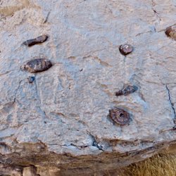
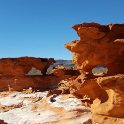
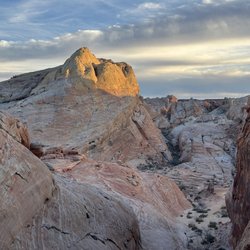
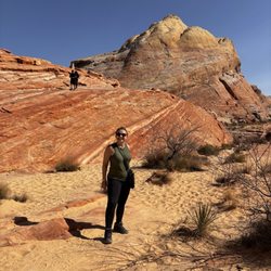
Mouse's Tank is a short hike, about 1/2 mile round trip, in Valley of Fire State Park. The reason for doing this hike is for its history. It got its name from an Indian nicknamed Mouse who hid from the authorities in the 1890s. It's an interesting story how he eluded authorities for months. The tank, a natural depression in the sandstone, is at the end of the hike. It's not much to see because you can't get in a location to see the whole thing. It's believed Mouse may have used this tank and others like it for water to keep him alive. There's also a theory that he was not guilty for which they were trying to capture him. The other history was left by the Indians on the sandstone walls along the trail. These petroglyphs are very good representations of many different things. Some, such as bighorn sheep, are easy to identify. Others may not represent anything, but they are what you think they are because no one knows for sure. They are mostly on the left side of the trail and some are very vivid and in great detail. The sand along this trail is very fine so walking at times may be difficult. There is one petroglyph on the right side of the trail that is difficult to find and you have to walk on a narrow ledge to see the whole thing. They have nicknamed it the Mystical Bat Woman. One note that most visitors miss is that when you end your short hike of Mouse's Tank, if you cross the White Domes Road, there are a whole other series of petroglyphs to the left of the picnic area. They are excellent! Enjoy the petroglyphs and respect our history. Don't touch them, trace them, or mark on them with chalk. They can never be replaced. Note: Since this is such a short walk, it's good to do this and then go on to the White Domes hike at the end of this road.


Mouse's Tank is the first parking lot after the Visitor's Center. The trail is very short and can be done by almost any skill level. The trail is very sandy and took us about 10 minutes to get to the end. Petroglyph Canyon Trail is also part of this hike where you can look and enjoy the petroglyphs on the rocks above you. TIP #1: Respect the petroglyphs. Do not mess with them. TIP #2: Petroglyph translations can be found at the trailhead TIP #3: This trail is a good warm up or "add on" to the other trails in Valley of Fire. 2017 Hike Review #10 / 2017 Yelp Review #84

It is one of the shorter trail and easy access for Valley of Fire. It is 1.1 miles from Valley of Fire. The entire trail last 1 miles round trip. Sandy trail with least strength and elevation differences is minor. Along the trail has petroglyphs on the wall. We saw human holding hand. I believe there is very much how many in the family. We also saw shape like goat, big horn sheep or deer. The drawing is interesting for many years ago. At the end of the track like small pool where look like mouse trap. This trail just need to bring camera. You will not require water. read more


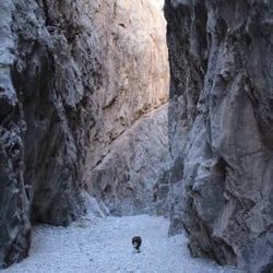
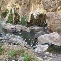
This was our first hike inside the Valley of Fire. It is only .7 mikes but on the scorching day in July it was pretty challenging because of the heat. The trail is fairly easy to walk but the surface is soft sand so it takes a little longer to hike than it would on a hard surface. (In July the sand is so hot it burns right through your socks & sneakers!) Also there's not much breeze because there are large sandstone formations on each side of the trail. At the end there's a small opening where you can spy a hidden water source down a ways. (We May not have spotted it if we hadn't seen some birds flying overhead because there was no additional signage.). The trail is called a Mouse's Tank because there was a renegade Paiute Indian who was said to have secluded himself here in the 1890's. The Mojave Desert is extremely hot & dry; so this water source most likely kept him alive. Although the hike was short, I feel like it could have been marked a little better. Like I mentioned we almost missed the water source at the end of the trail because there was no signage. There were also supposed to be petroglyphs along the way, however we missed those too because there was no signs pointing them out. read more


WOW! This was an amazing short, kid-friendly, and as-difficult-as-you-want-it hike! The main trail is mostly sandy. This wasn't an issue on the beautiful, 50°, clear-weather day we were there late December. However, you may choose to climb here and there to get different views or a different level of workout. There are petroglyphs along the hike which is especially fun for kids to look out for and spot. At the start of the trail there is a key that gives possible interpretations for the symbols. We think we got to the end of the trail. There was a sharp "up" right after a small puddle of water after turning left that didn't seem to have a way down. The trail was well-trafficked but it didn't feel crowded. Everyone was passed was very kind and there were even enough people to take group photos for us every now and again. read more


Mouse's Tank is a short hike, about 1/2 mile round trip, in Valley of Fire State Park. The reason for doing this hike is for its history. It got its name from an Indian nicknamed Mouse who hid from the authorities in the 1890s. It's an interesting story how he eluded authorities for months. The tank, a natural depression in the sandstone, is at the end of the hike. It's not much to see because you can't get in a location to see the whole thing. It's believed Mouse may have used this tank and others like it for water to keep him alive. There's also a theory that he was not guilty for which they were trying to capture him. The other history was left by the Indians on the sandstone walls along the trail. These petroglyphs are very good representations of many different things. Some, such as bighorn sheep, are easy to identify. Others may not represent anything, but they are what you think they are because no one knows for sure. They are mostly on the left side of the trail and some are very vivid and in great detail. The sand along this trail is very fine so walking at times may be difficult. There is one petroglyph on the right side of the trail that is difficult to find and you have to walk on a narrow ledge to see the whole thing. They have nicknamed it the Mystical Bat Woman. One note that most visitors miss is that when you end your short hike of Mouse's Tank, if you cross the White Domes Road, there are a whole other series of petroglyphs to the left of the picnic area. They are excellent! Enjoy the petroglyphs and respect our history. Don't touch them, trace them, or mark on them with chalk. They can never be replaced. Note: Since this is such a short walk, it's good to do this and then go on to the White Domes hike at the end of this road. read more


5 years ago
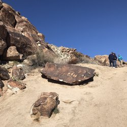
A short hike through an amazing rock canyon. The trail is flat & consist of sand. Lots of Petroglyphs to ponder their meaning. Notice the picture of Daleks & humans playing together. read more


Mouse's Tank is the first parking lot after the Visitor's Center. The trail is very short and can be done by almost any skill level. The trail is very sandy and took us about 10 minutes to get to the end. Petroglyph Canyon Trail is also part of this hike where you can look and enjoy the petroglyphs on the rocks above you. TIP #1: Respect the petroglyphs. Do not mess with them. TIP #2: Petroglyph translations can be found at the trailhead TIP #3: This trail is a good warm up or "add on" to the other trails in Valley of Fire. 2017 Hike Review #10 / 2017 Yelp Review #84 read more


12 years ago
One of the best trails at the Valley of Fire state park. Look for petroglyphs along the trail. Easy mostly flat trail except the fine sand on the road. It's hard to walk like on the beach and get sand in your shoes. read more


9 years ago
More info about Mouse's Tank
Ask the Community - Mouse's Tank
Review Highlights - Mouse's Tank


Mouse's Tank - hiking - Updated July 2026
Best of Overton
People found Mouse's Tank by searching for…
Things to Do in Overton, Nevada
Hiking Trails in Overton, Nevada
Bird Sanctuary in Overton, Nevada
Scenic Drive in Overton, Nevada
Rock Climbing in Overton, Nevada
Visitor Centers in Overton, Nevada
Scenic Views in Overton, Nevada
Swimming Lakes in Overton, Nevada
Off Road Trails in Overton, Nevada
Parks for Kids in Overton, Nevada
Hikes With Dogs in Overton, Nevada
Secret Spots in Overton, Nevada
Walking Trails in Overton, Nevada
Photo Spots in Overton, Nevada
Picnic Areas in Overton, Nevada
Stroller Friendly Hikes in Overton, Nevada
Kids Friendly Beaches in Overton, Nevada