Joppenbergh Mountain Photos


You might also consider
More like Joppenbergh Mountain
Recommended Reviews - Joppenbergh Mountain
Start your review...

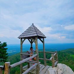
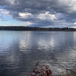
Came here with a group of friends, and was a great discovery they chose. For anyone who enjoys wonderful views and scenery, this is it. Coming into the parking lot requires caution, because the driveway is narrow, only fitting one car at a time. Getting in, there are plenty of parking spots to park at. Take note, on Sundays from 8am to 2pm, the inner parking lot is blocked off due to a Farmers Market, which makes the lot busy and packed. There are a number of trails to choose from, which takes place further inside the park. We only did two trails, the green, and yellow, doing a complete loop including a summit lookout, with a wonderful view looking south, overlooking the Rosendale Trestle, which is the Walkill Valley Rail Trail. The trail which we took is steep, containing a lot of rocks and some tree stumps. The other trails will be explored in the future. Overall, a great trail and park to visit. read more


More info about Joppenbergh Mountain
Hardenburgh Ln
Rosendale, NY 12401
Directions
Visit Website
https://wallkillvalleylt.org
Hours
Outdoor Amenities


Joppenbergh Mountain - hiking - Updated July 2026
Best of Rosendale
People found Joppenbergh Mountain by searching for…
Hiking Trails With Waterfalls in Rosendale, New York
Things to Do in Rosendale, New York
Scenic Overlook in Rosendale, New York
Scenic View in Rosendale, New York
Walking Trails in Rosendale, New York
Swimming Holes in Rosendale, New York
Swimming Lakes in Rosendale, New York
Things to Do on a Rainy Day in Rosendale, New York
Easy Hiking Trails in Rosendale, New York
Beautiful Views in Rosendale, New York
Swimming in Rosendale, New York
Lookout Points in Rosendale, New York
Fall Foliage in Rosendale, New York
Places to Take Pictures in Rosendale, New York
Dog Friendly Trails in Rosendale, New York
Things to Do at Night in Rosendale, New York
Watch Sunset in Rosendale, New York
Fishing Spots in Rosendale, New York
Dog Friendly Beaches in Rosendale, New York
Browse Nearby
BEST of Rosendale, New York Things to Do near Joppenbergh Mountain
BEST of Rosendale, New York Coffee near Joppenbergh Mountain
BEST of Rosendale, New York Restaurants near Joppenbergh Mountain
BEST of Rosendale, New York Parks near Joppenbergh Mountain
BEST of Rosendale, New York Breakfast near Joppenbergh Mountain
BEST of Rosendale, New York Lakes near Joppenbergh Mountain
BEST of Rosendale, New York Campgrounds near Joppenbergh Mountain