Giant Ledge - Panther Mountain Photos


You might also consider
More like Giant Ledge - Panther Mountain
Recommended Reviews - Giant Ledge - Panther Mountain
Start your review...

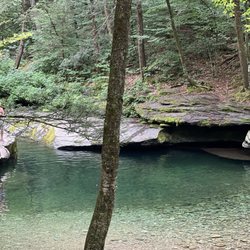
Absolutely stunning for a sunrise hike. My friends and I have done this for the past two years around mid October. Get to the trailhead at 5 AM and spend the next hour and a half climbing to the peak to see sunrise. Excellent bang for your buck Hike. I think it's only like a one and a half mile track, but it's the elevation that gives difficulty. Check out my photos and videos. I highly recommend this. read more


If you are not a advanced hiker, this mountain is for you. It's elevation is not difficult to climb and there are very few obstacles on the trail. My fiancé, the dogs, and I did very well climbing up and enjoying the views at the top. It is that perfect hike for eating lunch at the top. You don't over do yourself and that makes it very enjoyable. I really loved the views of the other mountains while I was at the top. We hiked in the Fall and it was great seeing the colors! read more

4 years ago
5 years ago
More info about Giant Ledge - Panther Mountain
Phoenicia, NY 12464
Directions
Hours
Outdoor Amenities


Giant Ledge - Panther Mountain - hiking - Updated May 2026
Best of Phoenicia
People found Giant Ledge - Panther Mountain by searching for…
Things to Do in Phoenicia, New York
Hiking Trails in Phoenicia, New York
Easy Hikes in Phoenicia, New York
Scenic Overlook in Phoenicia, New York
Waterfall Hike in Phoenicia, New York
View Points in Phoenicia, New York
Off Road Trails in Phoenicia, New York
Dog Friendly Hiking Trails in Phoenicia, New York
Walking Trails in Phoenicia, New York
Hikes With Dogs in Phoenicia, New York
Sunrise View in Phoenicia, New York
Waterfalls in Phoenicia, New York
Scenic View in Phoenicia, New York
Fall Foliage in Phoenicia, New York
Night View in Phoenicia, New York
Lookout Points in Phoenicia, New York
Running Trails in Phoenicia, New York
Photo Spots in Phoenicia, New York
Night Hike in Phoenicia, New York
Trending Searches in Phoenicia, NY
Boat Rental near Giant Ledge - Panther Mountain
Campgrounds near Giant Ledge - Panther Mountain
Hair near Giant Ledge - Panther Mountain
Nurseries & Gardening near Giant Ledge - Panther Mountain
Parks near Giant Ledge - Panther Mountain
Party Equipment Rentals near Giant Ledge - Panther Mountain
Pick Your Own Farms near Giant Ledge - Panther Mountain
Places To Take Pictures near Giant Ledge - Panther Mountain
Running Trails near Giant Ledge - Panther Mountain
Secret Spots near Giant Ledge - Panther Mountain
Swimming Holes near Giant Ledge - Panther Mountain
Browse Articles
Browse Nearby
BEST of Phoenicia, New York Restaurants near Giant Ledge - Panther Mountain
BEST of Phoenicia, New York Coffee near Giant Ledge - Panther Mountain
BEST of Phoenicia, New York Things to Do near Giant Ledge - Panther Mountain
BEST of Phoenicia, New York Breakfast near Giant Ledge - Panther Mountain
BEST of Phoenicia, New York Shopping near Giant Ledge - Panther Mountain
BEST of Phoenicia, New York Hotels near Giant Ledge - Panther Mountain
Browse Brands
Related Searches in Phoenicia, NY
Affordable Kayak Rental Services in Phoenicia, New York
Best Fishing Locations and Guides in Phoenicia, New York
Best Lookout Points to Visit in Phoenicia, New York
Best Places for Horseback Riding in Phoenicia, New York
Best Sledding Spots and Fun in Phoenicia, New York
Best Spots for Star Gazing in Phoenicia, New York
Best Waterfalls and Swimming Holes in Phoenicia, New York
Discover Dog Friendly Trails to Explore in Phoenicia, New York
Discover Kid Friendly Hiking Trails in Phoenicia, New York
Discover a Hiking Trail in Phoenicia, New York
Discover the Best Night Hike Trails in Phoenicia, New York
Dog-Friendly Hikes With Dogs in Phoenicia, New York
Enjoy Camping Adventures Around Phoenicia, New York
Enjoy Exciting Mountain Biking Adventures in Phoenicia, New York
Enjoy River Tubing Adventures in Phoenicia, New York
Enjoy the Best Tubing Experiences in Phoenicia, New York
Enjoy the Best Walking Trails in Phoenicia, New York
Experience Thrilling White Water Rafting in Phoenicia, New York
Explore Beautiful Parks and Green Spaces in Phoenicia, New York
Explore Bike Rentals Throughout Phoenicia, New York
Explore Easy Hikes Perfect for All in Phoenicia, New York
Explore Family-Friendly Zoos and Wildlife in Phoenicia, New York
Explore Free Things to Do Around Phoenicia, New York
Explore Fun Activities to Do in Phoenicia, New York
Explore Popular Campgrounds Near Phoenicia, New York
Explore Popular RV Parks Around Phoenicia, New York
Explore Popular Scenic Overlook Points in Phoenicia, New York
Explore Scenic Lakes to Visit in Phoenicia, New York
Explore Secret Spots Worth Visiting in Phoenicia, New York
Explore Top Dog Parks in Phoenicia, New York Near You
Explore Top Water Parks in Phoenicia, New York Today
Explore the Best Boating Spots in Phoenicia, New York
Explore the Best Swimming Holes Around Phoenicia, New York
Family Friendly Hiking With Kids in Phoenicia, New York
Find Fun Things to Do With Kids in Phoenicia, New York
Find Popular Ziplining Spots Around Phoenicia, New York
Find the Best Playgrounds to Visit in Phoenicia, New York
Hiking Trails With Waterfalls in Phoenicia, New York
Off Leash Dog Hiking Trails in Phoenicia, New York
Perfect Spots to Watch Sunset in Phoenicia, New York
Popular Fishing Spots to Explore in Phoenicia, New York
Popular Kids Activities in Phoenicia, New York
Popular Things to Do in Phoenicia, New York
Top Paddleboarding Activities in Phoenicia, New York
Top Running Trails to Explore in Phoenicia, New York
Top Swimming Spots and Pools in Phoenicia, New York
Top Things to Do With Kids in Phoenicia, New York
Top-Rated Basketball Courts to Play at in Phoenicia, New York