Devils Path Photos


More like Devils Path
Recommended Reviews - Devils Path
Start your review...

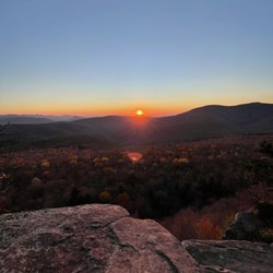
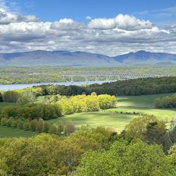
Wow, talk about a beautiful drive to get here! Completely isolated with the surrounding town bringing you to the past. The narrow zig-zag roads getting here from the east are a blast to drive on. Taking the devil's path is no joke if you're doing the whole trail. Highly suggest packing light for the hike. Totally regretted my 35lb backpack setup. The elevation spikes and drops will put your knees and ankles to the test. The look out points are gorgeous. Each one deserves to be taken in during a break. The biodiversity is incredible here. You'll notice the nature changes at different points of the hike. Including the areas casted in darkness from the dense trees. The next drinkable source of water from the beginning is a far distance so make sure you pack accordingly. The devils tombstone is the halfway point which is where most people set up camp. Cant harp enough... snacks, snacks, snacks. Stay safe if you choose to part take on this hike! One of the best hikes I've been on. read more


The infamous Devils Path! This trail is infamous for being extremely difficult. Is Devils Path difficult? No and yes! For any experienced hiker doing any of the shorter trails it is fairly straight forward and I'd say fairly easy (for an experienced hiker). What makes DP extremely hard or difficult is when you attempt the entire length in one day. You go up and down five mountains throughout the trip and while any experienced hiker will say going down the mountains can be worst than going up, after you are on your way up the 5th mountain doing DP you will welcome downhill really fast. LOL! I hiked Devils Path with a group of 4 strong experienced hikers for a day trip. We started at Prediger Road, left a car in the middle of our planned route at Stony Clove Notch and finally we left car at our end target Spruceton parking lot. We had lunch at Stony Clove where we refilled our water supplies with the water spout we found there. We assessed our personal abilities and decided we were all in excellent shape and able to keep pressing forward to complete our goal to finish DP in one day. Best advice I can give anyone that is daring to attempt this in a single day is (1) be experience with the distance having done at least 15 miles minimum in the past and (2) bring FOOD, lots of food (leave the diet at home). Also, plan a bail out point in case you realize the distance is too great for you. Devils Path to me isn't so much a hard trail to do but it most certainly is a trail that will test your endurance to the max! My group did car spotting at 4:30am, started our journey about 6:30am and completed the full trail about 6:45pm just before sunset. Would I do this again? Probably not but I am proud to be in the small percentage of people to have completed this in a single day. The sense of accomplishment is resounding. I COMPLETED DEVILS PATH IN ONE DAY!! Woohoo!! :o) read more
. - Hiking Near Me - Elka Park, New York")

8 years ago
My favorite trail in the Catskills. 1) The Devils Path is a hikers dream. 2) You got amazing mountains with excellent views. 3) Twin Mountain is my favorite. read more


10 years ago
Where is my limit? What is the ultimate challenge for hikers? Devil's Path is probably the most challenging hike I had in the US. The whole path is 25miles, which is also referred to as one of the most dangerous hiking path in northeast due to the rapid elevation gains and descents (five peaks ~ 14,000 feet of ascent and descent in total!). It is the ultimate challenge in backpacking - every hiker's ultimate goal is to do an epic one day hike in DP! Have been talking about it with my hiking buddy for a year and now here we go! We made a one day hike in the eastern portion (13.5miles in 10hours)! (Eastern portion = Indian head, Twin, Sugarloaf, and Plateau; western portion = Hunter and West Kill). Serval suggestions and lessons we learnt from this hike: 1. Early start (full hike def starts before 530am; half hike can start around 7am); 2. Travel light (3L of water - only 2 refills 1) a water tube between Sugarloaf and Plateau. 2) at the tombstone campsite which is 13.5miles in; light jacket to start the day, headlamp, protein bars, nuts or chocolates, one trekking pole, and energy drinks!) 3. Pace yourself: the whole/half hike exhaustive and hard on legs/knees, so make sure you have the proper pace to accomplish your goal; 4. Drink a ton of water, eat nutritious food (calorie doesn't matter at this point! Have whatever you want =) and lastly have good sleeps after the hike! Cold bath/massage/light exercise also help to reduce the sourness. Overall the trail sign is obvious - just follow the red trail signs. In the eastern portion, the blue trail is a short cut trail. It's an unforgettable experience and def get your best hiking buddies to plan this trip with you! It was thrilling, exciting, at times scary yet way worth it. I got to push my limits in the last 4 miles of the eastern section (the steepest portion). But you only know when you tried! Have fun!! read more


8 years ago
More info about Devils Path


Devils Path - hiking - Updated June 2026
Best of Elka Park
People found Devils Path by searching for…
Hiking Trails in Elka Park, New York
Things to Do in Elka Park, New York
Sunset View in Elka Park, New York
Waterfall Hike in Elka Park, New York
Scenic Drive in Elka Park, New York
Easy Hikes in Elka Park, New York
Day Trips in Elka Park, New York
View Points in Elka Park, New York
Tent Camping in Elka Park, New York
Beautiful Views in Elka Park, New York
Waterfalls in Elka Park, New York
Walking Trails in Elka Park, New York
Off Road Trails in Elka Park, New York
Attractions in Elka Park, New York
Scenic Overlook in Elka Park, New York
Playgrounds in Elka Park, New York
Swimming Lakes in Elka Park, New York
Scenic View in Elka Park, New York
Fishing Spots in Elka Park, New York
Secluded Spots in Elka Park, New York
Running Trails in Elka Park, New York
Rock Quarry in Elka Park, New York