Falling Waters Preserve Photos


More like Falling Waters Preserve
Recommended Reviews - Falling Waters Preserve
Start your review...

Reviews With Photos

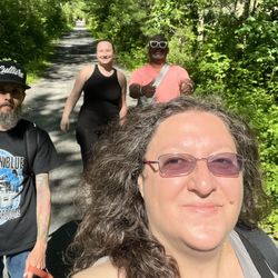
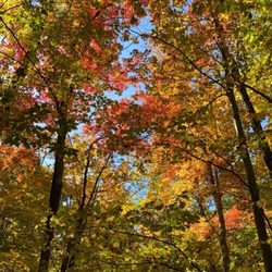
Awesome! This small preserve has several short and fairly easy trails. No huge jumps in elevation, though the one by the river is a little narrow and a little steep at times. We did this with some littles (5 and 6) and they were great. Much of the trail borders privately owned land so you might see some farm animals! Really scenic in the fall with the leaves, highly recommend!


This was a nice little hike. It's not very long but definitely worth doing. We went up the red trail and came down the white trail. The white trail does have some steep sections, nothing crazy but can be a bit dangerous if raining, snowing, overly crowded or if a dog/dogs off their lease comes running towards you while you're making your way up as there isn't much space for two walking side by side. That's what happened to me today. I was caught off guard so it was scary but thankfully all is well. I recommend this hike. It has beautiful views, benches here and there, and today for some reason the forest smelled amazing. :0)

On a recent trip towards the Catskills, we decided to stop to explore Saugerties, New York. Falling Waters Preserve is located along the Hudson River, and makes for a nice, short hike. I chose this one because it looked pretty family friendly and figured my kids could handle the hike. We used Google Maps to locate the Preserve, and had no trouble finding the parking lot, which holds probably a dozen cars. There was plenty of space to park, even when we left late morning. There is a nice kiosk at the trailhead, and there were actually trail maps there. I often find that when we go hiking, there are no maps left, and it was nice to have a map with us even for a short hike. We started on the white trail, which is close to the Hudson River and runs parallel to it. The trails are well-marked here, with markers on the trees, and it is easy to follow as the paths are well-maintained. There are lots of great views, even from the trail. At several places along the white trail, we ventured off on little paths that went to the water, and the kids even waded in a little bit. The Hudson River looked beautiful, and we had perfect weather. The green stuff floating on the water? (see my pics) Invasive plants called Chinese Water Chestnut. This is one of those things you want to be careful as you are walking around, as there are dried ones everywhere. You just want to make sure it doesn't go through something like a flip flop or even a sneaker. Unfortunately it has invaded so many waterways, you find them everywhere and it isn't something that can be removed because it is so abundant. Just watch your step. We continued and reached the waterfall overlook, which has a nice seating area with a pergola. In early June, the waterfall was flowing well. According to the Scenic Hudson website, the waterfall isn't always flowing, so it will likely dry up later in the year. We usually like to have scenic points along our hikes, so you may want to time your visit accordingly. You can either double back on the trail you came in on (for us, that was along the water), or take it as a loop. We did a loop, returning on a trail that is essentially parallel to the one that runs along the Hudson River. There is a nice statue as we looped back, where the preserve backs up to private property. We also saw some poison ivy along the trail, so be careful for that along with the Chinese Water Chestnuts. By taking the Riverside Trail in, and the Upland Trail out, we covered just over 1.5 miles. The trail is mostly flat, with only slightly rolling terrain, and was an easy hike for all of us.

Nice little walks, lots of water views, quiet and clean. I didn't even know it existed until a friend of mine stumbled across it and suggested we take the dogs! It's open year round from dawn to dusk. While we were there we saw senior citizens and people walking and pulling kids in a wagon - it's definitely a user friendly scene. There are also benches in shady areas along the trails, and maps (although they aren't really needed.) My only suggestion is that if you come the way Saugerties website suggests, be aware that Dominican Lane is a sharp (read, almost backwards) left. Our car almost couldn't make the turn. Can't wait to go back!

This is a fairly easy hike on a well-maintained trail that skirts the Hudson River. We were disappointed that the river didn't/doesn't look more impressive as there is quite a bit of duckweed growing in the river that takes away from its majesty. There are beautifully crafted, wooden benches along the trail and overlooking the ravine and small falls, and the white, red, and blue trail markers are clear and well-spaced. Expecting rain, we all carried and used umbrellas, and, with the canopy of the trees overhead, we were fine.

1 year ago


2 years ago
Awesome! This small preserve has several short and fairly easy trails. No huge jumps in elevation, though the one by the river is a little narrow and a little steep at times. We did this with some littles (5 and 6) and they were great. Much of the trail borders privately owned land so you might see some farm animals! Really scenic in the fall with the leaves, highly recommend! read more
Well-kept trails, with a beautiful waterfall and bench not far down the trail. I didn't do the white trail and stuck to the easy terrain as it was a recovery hike for me. Lots of great photo ops and views. And, there's no charge. Woot! read more


8 years ago
This was a nice little hike. It's not very long but definitely worth doing. We went up the red trail and came down the white trail. The white trail does have some steep sections, nothing crazy but can be a bit dangerous if raining, snowing, overly crowded or if a dog/dogs off their lease comes running towards you while you're making your way up as there isn't much space for two walking side by side. That's what happened to me today. I was caught off guard so it was scary but thankfully all is well. I recommend this hike. It has beautiful views, benches here and there, and today for some reason the forest smelled amazing. :0) read more


On a recent trip towards the Catskills, we decided to stop to explore Saugerties, New York. Falling Waters Preserve is located along the Hudson River, and makes for a nice, short hike. I chose this one because it looked pretty family friendly and figured my kids could handle the hike. We used Google Maps to locate the Preserve, and had no trouble finding the parking lot, which holds probably a dozen cars. There was plenty of space to park, even when we left late morning. There is a nice kiosk at the trailhead, and there were actually trail maps there. I often find that when we go hiking, there are no maps left, and it was nice to have a map with us even for a short hike. We started on the white trail, which is close to the Hudson River and runs parallel to it. The trails are well-marked here, with markers on the trees, and it is easy to follow as the paths are well-maintained. There are lots of great views, even from the trail. At several places along the white trail, we ventured off on little paths that went to the water, and the kids even waded in a little bit. The Hudson River looked beautiful, and we had perfect weather. The green stuff floating on the water? (see my pics) Invasive plants called Chinese Water Chestnut. This is one of those things you want to be careful as you are walking around, as there are dried ones everywhere. You just want to make sure it doesn't go through something like a flip flop or even a sneaker. Unfortunately it has invaded so many waterways, you find them everywhere and it isn't something that can be removed because it is so abundant. Just watch your step. We continued and reached the waterfall overlook, which has a nice seating area with a pergola. In early June, the waterfall was flowing well. According to the Scenic Hudson website, the waterfall isn't always flowing, so it will likely dry up later in the year. We usually like to have scenic points along our hikes, so you may want to time your visit accordingly. You can either double back on the trail you came in on (for us, that was along the water), or take it as a loop. We did a loop, returning on a trail that is essentially parallel to the one that runs along the Hudson River. There is a nice statue as we looped back, where the preserve backs up to private property. We also saw some poison ivy along the trail, so be careful for that along with the Chinese Water Chestnuts. By taking the Riverside Trail in, and the Upland Trail out, we covered just over 1.5 miles. The trail is mostly flat, with only slightly rolling terrain, and was an easy hike for all of us. read more


Nice little walks, lots of water views, quiet and clean. I didn't even know it existed until a friend of mine stumbled across it and suggested we take the dogs! It's open year round from dawn to dusk. While we were there we saw senior citizens and people walking and pulling kids in a wagon - it's definitely a user friendly scene. There are also benches in shady areas along the trails, and maps (although they aren't really needed.) My only suggestion is that if you come the way Saugerties website suggests, be aware that Dominican Lane is a sharp (read, almost backwards) left. Our car almost couldn't make the turn. Can't wait to go back! read more


This is a fairly easy hike on a well-maintained trail that skirts the Hudson River. We were disappointed that the river didn't/doesn't look more impressive as there is quite a bit of duckweed growing in the river that takes away from its majesty. There are beautifully crafted, wooden benches along the trail and overlooking the ravine and small falls, and the white, red, and blue trail markers are clear and well-spaced. Expecting rain, we all carried and used umbrellas, and, with the canopy of the trees overhead, we were fine. read more


5 years ago
8 years ago
It was a mild, gorgeous day, so it was pretty crowded. We got the last spot in the parking area. The red trail is quite easy. There are benches at fairly frequent intervals. The white/riverside trail I would classify as moderate, narrowed with loose stones, tree roots, sloping to sheer drop offs with no rails/barriers, and some steep hills with rocks. Also, no benches. My kids whined on this trail. The dog enjoyed the little beach at the river's edge. I enjoyed the lush forest and waterfall views. There was a nice seating area at one of the waterfalls. We did not go on the Father C. Jorn/blue trail, which I believe had the old icehouse on it and another waterfall. The family wasn't up for it. I'll definitely be back to check that out. Overall, I was very impressed with the trails at this preserve! Very well marked with flares and clear paths. read more


More info about Falling Waters Preserve
996 Dominican Ln
Glasco, NY 12432
Directions
(845) 473-4440
Call Now
Visit Website
http://www.scenichudson.org/parks/fallingwaters
Hours
Indoor Amenities
Outdoor Amenities
Ask the Community - Falling Waters Preserve
Review Highlights - Falling Waters Preserve


Falling Waters Preserve - hiking - Updated June 2026
Best of Glasco
People found Falling Waters Preserve by searching for…
Hiking Trails With Waterfalls in Glasco, New York
Things to Do in Glasco, New York
Fun Things to Do With Kids in Glasco, New York
Dog Friendly Beaches in Glasco, New York
Scenic View in Glasco, New York
Playgrounds in Glasco, New York
Attractions in Glasco, New York
Waterfalls and Swimming Holes in Glasco, New York
Walking Trails in Glasco, New York
Easy Hikes in Glasco, New York
Dog Friendly Parks in Glasco, New York
Waterfalls in Glasco, New York
Sunset View in Glasco, New York
Dog Friendly Hiking Trails in Glasco, New York
Photo Spots in Glasco, New York
Scenic Overlook in Glasco, New York
Off Road Trails in Glasco, New York
Running Trails in Glasco, New York
Hikes With Dogs in Glasco, New York
Off Leash Dog Hikes in Glasco, New York
Trending Searches in Glasco, NY
Black Owned Nail Salons near Falling Waters Preserve
Boat Rental near Falling Waters Preserve
Cliff Jumping near Falling Waters Preserve
Day Trips near Falling Waters Preserve
Dog Friendly Beaches near Falling Waters Preserve
Dog Friendly Trails near Falling Waters Preserve
Fishing Spots near Falling Waters Preserve
Fruit Picking near Falling Waters Preserve
Kayak Rental near Falling Waters Preserve
Off Road Trails near Falling Waters Preserve
Outdoor Activities near Falling Waters Preserve
Public Pools near Falling Waters Preserve
River Tubing near Falling Waters Preserve
Splash Pad near Falling Waters Preserve
Strawberry Picking near Falling Waters Preserve
Swimming Holes near Falling Waters Preserve
Swimming Lakes near Falling Waters Preserve
Browse Articles
Browse Nearby
BEST of Glasco, New York Coffee near Falling Waters Preserve
BEST of Glasco, New York Restaurants near Falling Waters Preserve
BEST of Glasco, New York Things to Do near Falling Waters Preserve
BEST of Glasco, New York Parks near Falling Waters Preserve
BEST of Glasco, New York Breakfast near Falling Waters Preserve
BEST of Glasco, New York Fishing near Falling Waters Preserve
Browse Brands
Related Searches in Glasco, NY
Affordable Kayak Rental Services in Glasco, New York
Best Fishing Locations and Guides in Glasco, New York
Best Places for Horseback Riding in Glasco, New York
Best Spots for Star Gazing in Glasco, New York
Best Waterfalls and Swimming Holes in Glasco, New York
Discover Dog Friendly Beaches Near Glasco, New York
Discover Dog Friendly Trails to Explore in Glasco, New York
Discover Scenic Waterfall Spots in Glasco, New York
Discover a Hiking Trail in Glasco, New York
Discover the Best Night Hike Trails in Glasco, New York
Discover the Best Running Track in Glasco, New York
Dog-Friendly Hikes With Dogs in Glasco, New York
Enjoy Camping Adventures Around Glasco, New York
Enjoy Exciting Mountain Biking Adventures in Glasco, New York
Enjoy Kayaking Adventures in Glasco, New York
Enjoy River Tubing Adventures in Glasco, New York
Enjoy Tent Camping Spots Around Glasco, New York
Enjoy the Best Tubing Experiences in Glasco, New York
Exciting Cliff Jumping Spots in Glasco, New York
Explore Beautiful Parks and Green Spaces in Glasco, New York
Explore Bike Rentals Throughout Glasco, New York
Explore Easy Hikes Perfect for All in Glasco, New York
Explore Fun Activities to Do in Glasco, New York
Explore Popular Campgrounds Near Glasco, New York
Explore Scenic Lakes to Visit in Glasco, New York
Explore Secret Spots Worth Visiting in Glasco, New York
Explore Top Dog Parks in Glasco, New York Near You
Explore Top Water Parks in Glasco, New York Today
Explore the Best Beach Spots in Glasco, New York
Explore the Best Boating Spots in Glasco, New York
Explore the Best Swimming Holes Around Glasco, New York
Family Friendly Hiking With Kids in Glasco, New York
Find Top Dog Swimming Spots in Glasco, New York
Find the Best Playgrounds to Visit in Glasco, New York
Find the Best Scenic View Locations in Glasco, New York
Hiking Trails With Waterfalls in Glasco, New York
Must-See Tourist Attractions Around Glasco, New York
Off Leash Dog Hiking Trails in Glasco, New York
Plan a Scenic Drive Route Near Glasco, New York
Popular Fishing Spots to Explore in Glasco, New York
Popular Outdoor Activities to Try in Glasco, New York
Popular Things to Do in Glasco, New York
Top Climbing Spots and Gyms in Glasco, New York
Top Paddleboarding Activities in Glasco, New York
Top Playgrounds for Kids to Enjoy in Glasco, New York
Top Running Trails to Explore in Glasco, New York
Top Swimming Lakes to Enjoy in Glasco, New York
Top Things to Do With Kids in Glasco, New York
People who viewed Falling Waters Preserve also viewed
Platte Clove Preserve
7 reviews
Ferncliff Forest
15 reviews
Devils Path
5 reviews
Esopus Bend Nature Preserve
2 reviews
Windham High Peak - Burnt Knob Loop
2 reviews
Hopeland Trails
1 review
Vosburgh Swamp Wildlife Management Area
1 review
Kaaterskill Clove
2 reviews
Vernooy Falls Trailhead
1 review
Lighthouse Park
2 reviews