Kaaterskill Falls Photos


More like Kaaterskill Falls
Recommended Reviews - Kaaterskill Falls
Start your review...

Reviews With Photos

We did the ~1 mile hike to the upper falls from the Scutt Road parking lot. The hike is fairly easy, though sections of the trail have a lot of rocks and roots. A few small hills, but not much elevation change. The viewing point gets quite crowded, so it's probably best to go during off peak times. We started out at 5:45pm and there were still lots of people there. Because it's been quite dry, the falls were not gushing, but still offered a satisfying steady stream. From the upper viewing point, you can see the hikers on the lower levels below. The lower hike winds around to the bottom pool of the falls, so it's kind of cool to see from above, almost like a mini Grand Canyon. It's worth the journey and the lower falls hike is probably quite nice too, but we didn't have time for it on this trip.

Kaaterskill Falls is a two-stage waterfall on Spruce Creek in the eastern Catskill Mountains of New York. The two cascades total 260 feet (79 m) in height, making Kaaterskill Falls one of the highest waterfalls in New York, and one of the Eastern United States' tallest waterfalls. Very cool place to stop and see....Enjoy!


The perfect place for some intermediate/ beginner hiking and trail walking! Great for families, friends, partners or even solo. There's free yes FREE parking at the summit with a map of directions! Porter potty restroom avail ( bring toiletries and disinfectants to be safe ). Bring plenty of water and light snacks to enjoy along the trails. Once you figure out your desired trail and witness the waterfall levels, you'll never want to leave! It's gorgeous and perfect scenic views!! There's also Park Police stationed around the falls for protection and information. Best time to visit can be during the fall months to see the colorful leaves. Or even winter when the falls have frozen over. * research for hours of operation and route direction. Enjoy!

The Catskills, located 2.5 hours from NYC, is the prime destination for hiking and sightseeing. There are many places to stay when you're upstate which includes the Getaway cabins in Eastern and Western Catskills. I went to visit the beautiful Kaaterskill Falls, a two stage waterfall. This is a prime location for a short hike. Additionally, you can opt to go to Boulder rock for a scenic route. I recommend wearing comfortable sneakers as the trail can get rough at times.

This was a beautiful trail and what's not is it has different ones . You have the platform where you can see the falls and you have multiple different hikes . Most are less than 2 miles . However don't let that fool you lol the stairs are insane . And some of the rocks are huge to get over BUT the view at the end is really worth it . We went when the water was down so the rocks weren't slippery but you still use caution. And good sense . The potties sucked but I was grateful to even have something . We saw all kinds of people on this hike young ones to old . It was my first hike and although a bit challenging I did enjoy myself . Word of caution though go early because it gets really crowded


As an avid outdoors person I do not see the appeal and massive attraction to this location! Granted I visited probably at the worst time with limited rainfall the days leading up to my visit but even with the falls at full force, sure it might look decent but for the nightmarish parking situation I'd skip this if you are simply coming to see the falls. If you are staying at the camp nearby then I suggest parking on the camp property cause you won't be charged an arm and leg for parking to see one waterfall. Access from camp grounds is even cheaper if you only paid for the "day use" option that allows you to park on a short trail that leads to the waterfall. If you are in the area for camping or some type of vacation I'd visit the falls but if you are coming out solely for the waterfall I'd suggest not bothering but that's just my opinion.

I hit this spot for a morning hike and it was a solid, straightforward experience. First off, the logistics are easy. There's plenty of parking, and all the trails are clearly marked, so you won't get lost. Just note that while the lot has Porta-potties, there are no bathrooms once you're on the trails or at the viewpoints. Plan accordingly. The hike itself starts off pretty easy. The upper level hike is very mellow, offering great views of the landscape. At the top of the waterfall, there's a park employee there specifically to make sure no one gets too close to the edge. He's a friendly guy--his face genuinely lights up when you engage him with questions, so feel free to chat him up. The difficulty ramps up significantly once the trail splits between the upper and lower sections. The routes to the mid-level and lower levels of the falls are much more challenging. Be prepared for a lot of stairs heading down to the bottom. The positive tradeoff is that because of the tree canopy, the base of the waterfall is generally cooler, which is a nice break after the steep descent. Overall, it's a good spot with manageable trails up high and a decent workout if you commit to going down to the base.

Went in winter time. Wonderful trail down to the falls if you want to go to the base from the top parking lot close to the falls viewing platform. If you don't want to walk to end of falls, there is a viewing platform about half a mile from the parking. Challenging walk to the base with lots of stairs. Can be very slippery in winter time. Best to wear shoes with good grip. Would rate the trail as moderate.

This hike was enjoyable, especially if you're looking for a short walk with some beautiful scenery. The trail has a few ups and downs, but nothing too intense. Wear comfortable sneakers or boots for those rainy days. The waterfall at the end is pleasant--nothing enormous, but it's a pretty view, especially if you're into a quieter, nature-filled spot. You can feel the mist as you get closer, which is a nice touch after walking for a bit. Just know that it's a popular spot, so you'll probably run into a few other people. We celebrated our anniversary with a hike and we enjoyed it very much! We will be back to do the longer more difficult trail


1 month ago
The falls are truly incredible. The trail down to the bottom of the falls, is a bit tricky. But so incredibly worth it. I would suggest not to believe the sign saying 189 steps.... it is definitely more! Take drinking water because you'll need that for sure. We went back in August and the heat was definitely there. The parking lot was pretty packed but throughout the trails people were pretty evenly spaced out. Not so much at the base of the falls themselves but there was still plenty of room to move around freely. read more


3 months ago
One of the tallest waterfall in NY, similar height to Taughannock Falls. Physical requirement is different tho, Kaaterskill Falls has about 500foot of elevation change and a lot of slippery stone steps at the end, if you come here when the weather is still cold. Parking: most people park at the Laurel-House Road parking area, because it is the closest. Or you can park at Mountain Top Historical Society, the old train station, which an extra mile. Starting from the old railroad station is nice, you can still see some old tracks on the ground. Walk to the overlook is fairly easy, once you get to the start point of Lower falls junction, it is where you need to be prepared. I recommend hiking shoe, especially in colder months where the ground is wet and iced. When you reach to the stone steps, they can get slippery. I am surprised no one fell in late March. Half of the steps were cover in ice and people were wearing regular sneakers. Once you reach the base of the two tier falls, the view is tremendous. If water levels are high, you can feel the energy of the water. There is a lot of spray from the falls when you get close. There is short trail to the middle tier pool. It was iced up during winter, spikes will definitely be useful. The end was amazing too. So close to the lead of the waterfall. You can keep going and follow Escarpment trail and follow the edge of the valley. There is monument for fireman Frank Layman who died during firefighting in 1900, at his monument, you can see route 23A bend around mountain. And if you keep going, there are a couple viewpoint to overlook the valley. Nice break points to enjoy the view and rest your legs. read more


4 days ago
When I initially wrote this review I had taken the longer trail from the main road which has since closed off the parking area due to safety concerns. During my recent trip, I parked at the Laurel House parking lot that is up the road from North South Lake campground and it not only offers a much larger parking lot, but faster, more direct trails to viewing the upper and lower falls. The trail down to the lower falls has about 200 stone steps that range from steep to shallow and become very slippery when wet. There is a natural swimming pool below the falls. To get closer, you have to take less defined dirt trails and rely on intricate root systems to support you on the way up. It can be done safely but should not be rushed. The trail to the lower falls and back round trip is almost 2 miles and takes about 1-1.5 hours to complete. This is the most popular attraction in the area and is always very busy, but it is well worth the visit. read more


We did the ~1 mile hike to the upper falls from the Scutt Road parking lot. The hike is fairly easy, though sections of the trail have a lot of rocks and roots. A few small hills, but not much elevation change. The viewing point gets quite crowded, so it's probably best to go during off peak times. We started out at 5:45pm and there were still lots of people there. Because it's been quite dry, the falls were not gushing, but still offered a satisfying steady stream. From the upper viewing point, you can see the hikers on the lower levels below. The lower hike winds around to the bottom pool of the falls, so it's kind of cool to see from above, almost like a mini Grand Canyon. It's worth the journey and the lower falls hike is probably quite nice too, but we didn't have time for it on this trip. read more

1 year ago
Beautiful hiking trail. Beautiful falls at the end. Definitely worth returning here during fall season. The campground near is one of our favorites and coming here will always be wonderful side trip. read more


4 months ago
Kaaterskill Falls is a two-stage waterfall on Spruce Creek in the eastern Catskill Mountains of New York. The two cascades total 260 feet (79 m) in height, making Kaaterskill Falls one of the highest waterfalls in New York, and one of the Eastern United States' tallest waterfalls. Very cool place to stop and see....Enjoy! read more

11 months ago
Lovely waterfall but when we went it was more of a water-trickle. Easy hike--flat. Not too buggy and it was well marked. read more


The perfect place for some intermediate/ beginner hiking and trail walking! Great for families, friends, partners or even solo. There's free yes FREE parking at the summit with a map of directions! Porter potty restroom avail ( bring toiletries and disinfectants to be safe ). Bring plenty of water and light snacks to enjoy along the trails. Once you figure out your desired trail and witness the waterfall levels, you'll never want to leave! It's gorgeous and perfect scenic views!! There's also Park Police stationed around the falls for protection and information. Best time to visit can be during the fall months to see the colorful leaves. Or even winter when the falls have frozen over. * research for hours of operation and route direction. Enjoy! read more


2 years ago
The Catskills, located 2.5 hours from NYC, is the prime destination for hiking and sightseeing. There are many places to stay when you're upstate which includes the Getaway cabins in Eastern and Western Catskills. I went to visit the beautiful Kaaterskill Falls, a two stage waterfall. This is a prime location for a short hike. Additionally, you can opt to go to Boulder rock for a scenic route. I recommend wearing comfortable sneakers as the trail can get rough at times. read more


2 years ago
This was a beautiful trail and what's not is it has different ones . You have the platform where you can see the falls and you have multiple different hikes . Most are less than 2 miles . However don't let that fool you lol the stairs are insane . And some of the rocks are huge to get over BUT the view at the end is really worth it . We went when the water was down so the rocks weren't slippery but you still use caution. And good sense . The potties sucked but I was grateful to even have something . We saw all kinds of people on this hike young ones to old . It was my first hike and although a bit challenging I did enjoy myself . Word of caution though go early because it gets really crowded read more


Amazing winter hike to see the frozen falls. The viewing platform is good for all ages, though if you want to trek down to the lower falls, be prepared with the right gear and foot ware. We wore spikes and had treks g poles and I am glad we did. read more

As an avid outdoors person I do not see the appeal and massive attraction to this location! Granted I visited probably at the worst time with limited rainfall the days leading up to my visit but even with the falls at full force, sure it might look decent but for the nightmarish parking situation I'd skip this if you are simply coming to see the falls. If you are staying at the camp nearby then I suggest parking on the camp property cause you won't be charged an arm and leg for parking to see one waterfall. Access from camp grounds is even cheaper if you only paid for the "day use" option that allows you to park on a short trail that leads to the waterfall. If you are in the area for camping or some type of vacation I'd visit the falls but if you are coming out solely for the waterfall I'd suggest not bothering but that's just my opinion. read more

9 months ago
I hit this spot for a morning hike and it was a solid, straightforward experience. First off, the logistics are easy. There's plenty of parking, and all the trails are clearly marked, so you won't get lost. Just note that while the lot has Porta-potties, there are no bathrooms once you're on the trails or at the viewpoints. Plan accordingly. The hike itself starts off pretty easy. The upper level hike is very mellow, offering great views of the landscape. At the top of the waterfall, there's a park employee there specifically to make sure no one gets too close to the edge. He's a friendly guy--his face genuinely lights up when you engage him with questions, so feel free to chat him up. The difficulty ramps up significantly once the trail splits between the upper and lower sections. The routes to the mid-level and lower levels of the falls are much more challenging. Be prepared for a lot of stairs heading down to the bottom. The positive tradeoff is that because of the tree canopy, the base of the waterfall is generally cooler, which is a nice break after the steep descent. Overall, it's a good spot with manageable trails up high and a decent workout if you commit to going down to the base. read more

Went in winter time. Wonderful trail down to the falls if you want to go to the base from the top parking lot close to the falls viewing platform. If you don't want to walk to end of falls, there is a viewing platform about half a mile from the parking. Challenging walk to the base with lots of stairs. Can be very slippery in winter time. Best to wear shoes with good grip. Would rate the trail as moderate. read more


2 years ago
This hike was enjoyable, especially if you're looking for a short walk with some beautiful scenery. The trail has a few ups and downs, but nothing too intense. Wear comfortable sneakers or boots for those rainy days. The waterfall at the end is pleasant--nothing enormous, but it's a pretty view, especially if you're into a quieter, nature-filled spot. You can feel the mist as you get closer, which is a nice touch after walking for a bit. Just know that it's a popular spot, so you'll probably run into a few other people. We celebrated our anniversary with a hike and we enjoyed it very much! We will be back to do the longer more difficult trail read more

7 months ago
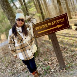
In November, we drove up to the entrance from Hudson. High enough up that we got the first showers of snow we had seen. Lovely short walk through the woods. to the viewing platform. Incredible views of the falls. Highly recommend. Short lovely adventure. read more


Great hiking area. You can see many falls within a short distance. When the weather is temperate, it is VERY crowded. It can also get very slippery & muddy when wet. There are rocks at the base of the main falls where you can sit and enjoy your lunch. read more


3 years ago
This is beautiful place to see waterfalls from two different locations. It has multiple trails from 5 miles to less than 1 mile. Waterfall is amazing. I did not know you can swim or bath there. If you want to then bring your swimsuit. Hiking are little difficult so for older and heart issue person should avoid. read more

11 months ago
This place was gorgeous. Dangerous, deadly, and had me questioning my life choices, but gorgeous all the same. We had the entire place to ourselves for quite a bit. We like to be leaving when everyone else is coming onto the trail. We had no shoe spikes and had to be SUPER careful. I almost feel like I would be bored if I came back in the summer or spring and actually could see the ground instead of solid ice. The waterfall was AMAZING and since it was frozen over, we could stand in it and bask in the glory of Mother Nature. We stayed in the area for a weekend, but I could see myself driving up for a day and coming back down. But there's just so much to do out in the world, you it owe it to yourselves, and by you I mean city slickers, to go on out there and smell pine instead of pollution. Feel the rays of the sun on your skin instead of the saliva of that random dude on the sidewalk who talks with his mouth open when you're heading to work. Disclaimer: If you do this in the winter, bring spikes and health insurance ID card. read more


4 years ago
There are so many trails that can bring you to the lower falls, however, the easiest way is to park at Laurel House Trail Parking lot. The hike will be only about 0.7 mile to the lower falls from the Laurel House Trailheads. You will also get a great view from the viewing Platform. I did the Rail Trail with my kids, it was a longer walk, but the path was flat and very kids friendly. The trail to lower falls was clear marked. It did get a bit challenging with steps toward the end of the trail, before we got to the bottom of the falls. Everything was worthy and the falls looked great! read more


4 years ago
You will not be disappointed (unless it's too crowded). Come on a weekday because the weekends are super crowded. There used to be a small parking lot by Bastion Falls but that's closed so now you park at Laurel House Road. Came on a Thursday and several times, we had the waterfalls to ourselves. I've come on the weekends and it was just too crowded to enjoy whether on the trails, by the waterfalls or observation point so plan accordingly. read more


Stopped by Kaaterskill Falls on Day 4 of my five day summer trip to the Catskills and it ended up being my favorite trail of the entire trip. The trail itself was fairly short, but the hike from the Bastion Falls trailhead to the upper stage was really pleasant. Seems to be a hot spot for tourists to hike, swim, and lounge by the falls. I even saw a few influencer-type people having photos shoots among the crowd. I parked on the parking area on Route 23A which had sufficient parking in the morning (around 9:30am), though I noticed that it started getting a bit crowded in the afternoon. I just barely managed to avoid getting double parked in as we left around noon. read more
 - Hiking Near Me")
 - Hiking Near Me")
 - Hiking Near Me")
6 years ago
Kaaterskill Falls Okay, let's be real for a second. You can't review nature. That's just ridiculous. "I didn't like how there wasn't a lot of water coming down and the rocks were slippery due to condensation and there wasn't enough shade from the sun and blah blah blah." Hopefully, you're not someone who did this with something naturally found in the world. For me, yeah I'm reviewing Kaaterskill Falls, but I'm gonna try to do this from a manmade angle. How so? Well around the Falls is where you'll get a lot of the actual features that were additions to the wooded area (and viable for reviewing). Let's start with the two trails you can take to enter and find Kaaterskill, though I want my review to truly help others in ensuring they aren't squashed by an 18-wheeler semi trailer truck. The trailhead along Route 23A is a great place to start with Bastion Falls as a breathtaking marker, but there's no safe way to get there. A five-minute walk away is the tiniest of parking lots right on the side of this windy road. If you can snag a spot, you'll then have to walk those five minutes on treacherous turns with basically no shoulder or path to walk on as cars can come zooming around curves and corners. Sound fun? It's not, but luckily, I was only a driver and never a hiker in this area. That's because THERE IS A MUCH SAFER WAY TO GO! I'm not sure why it isn't more publicized (most of my research brought me to that scary little lot), but if you take the upper trailhead to Laurel House Road, you'll come to an actual parking lot that's not on a bustling street with much easier access to the woods and Falls. Yeah, some of the excitement is taken out of it all by starting at the top and not working your way through from the Route 23A entrance, but c'mon people, it just makes sense to go in from here. You'll still get to see everything and you won't fear for your life (though you'll have a nice hike back up to finish off the day). From that upper trailhead, there are paved paths that lead to a few different trails as well as the viewing platform for Kaaterskill Falls. It's a nice thing to check out, even if you're farther from the Falls, just to get a glimpse of it from a higher vantage point and a pretty decent shot of the mountainous horizon. Once done, you can head over the manmade bridge and down the trail to the lower part of the Falls. This path is still through the woods with some angled spots that look over a steep-ish hill of trees, but most of it has been curated via construction to create an easier walk to this natural beauty. The large steps that lead down to the bottom of the Falls just make things safer when wanting to gaze up at its glory. There's also a path (with rope barricade) that leads you to the higher platform and where you'll really get your Kaaterskill experience as you could walk right up to the falling water, if you wanted. We came pretty close to it, but the mist coming off was nice enough to cool us down from our hike. Here's where you can also easily become a pancake if you head too close to the edge of the rocks to look down at the rest of the Falls. Heed those warning signs! I promise, you can still get a good Instagram pic even from a safe distance. And I'm not gonna tell you everything we did was 100% kosher. There is a small pathway you can take to get up and go around the back of the Falls. It's totally not meant to be done (the State didn't create this part), but people were doing it and we felt we could handle the slight adventure. Just be careful of the slippery rocks. Overall, I did my best here in not reviewing nature. Yeah, that last paragraph talks about Kaaterskill Falls itself, but the real review is just everything around the area that's been created and added by New York's Department of Environmental Conservation. They've done a solid job in making things safer (though that lower trailhead needs a path for people) and generating a great hiking experience for your novice nature lover. So if you come to Kaaterskill, yeah maybe the jet of water isn't as strong as you'd like or there are a lot of bugs or the ground is muddy, but hey, give Mother Nature a break and don't review her. read more


7 years ago
Beautiful and amazing waterfalls. This two tiered waterfall is even taller than niagara. This is a verrrry popular destination so please come either on a weekday or come super early. People also swim here Please! Please be careful tho cuz people have slipped and died or Injured themselves. Tip: go to a gas station or mcdonalds to use their restrooms before reaching the falls. They have portapotties at the falls, and I've heard its not that nice. I came on a mid May Sunday morning in 2021. Drove 2 hrs and 45min from Brooklyn. Arrived around 930am and parked at the laurel house parking lot. The place wasn't too packed at that time. Its a short walk to the viewing platform where you can see the top of the waterfall. Its also a short hike down to the base of kaaterskill waterfall. Some areas are pretty steep so be careful! It wasn't that busy at the falls yet either at this time. I was able to sit on a huge rock and have a peanut butter sandwich and enjoy the views. If u hike further down from the base of kaaterskill falls, u will reach Bastion falls which also looks nice. I took my sweet time hiking all the way down to bastion falls. Then on my way up as I reached kaaterskills falls again, it was really crowded there, around 11am. When I got back up to the parking lot, it was packed and I noticed alot of cars parked on the road where it says "do not park"...big mistake. You will get a ticket. There are more parking lots if this one is full! read more


Whether you're a seasoned hiker or just a fan of chasing waterfalls, Kaaterskill Falls should be on your list of places to visit. My husband and I visited the lower falls area in the middle of spring around mid May. The trail is relatively easy, well marked and maintained by the state. It's very important that those who hike there stay on the trail for safety. The area has been known for injury or deaths usually because of people wandering off trail or taking risks exploring the area. I did see some people being a bit careless trying to cut through and some were slipping around since they did not take the extra time to just walk on maintained path. Luckily no one injured themselves, but I wound not recommend to risk injury just to save a few minutes. First rule in hiking is safety first. We parked at the Laurel House Trailhead parking which has a good amount of spots, but in busy season probably can easily be filled up. When first starting at this trailhead, there is an overlook view about five minutes into the hike just before the bridge crossing by taking the path to the right at the bridge. After checking that out, return to the bridge to cross it to the trailhead markers and follow the path to the lower falls. The hike is roughly less than a mile down to the bottom. There are areas (more towards the bottom) where the steps are steeper, so on the return trip back it may take some extra time to go back up hill. The journey is well worth it. At this point it is also important to note there really isn't any handrail to hold onto, so take your time, so you won't injure yourself. The upper gorge area of the upper falls has a nice waterfall in your face view. Then proceed to the lower falls which you will see both levels of the famous waterfall. We had a great time here and would definitely return again in the future. Next time we hope to take the blue path to Inspiration Point. read more


Kaaterskill falls is absolutely stunning. There are what I'd call two tiers to it. The first being the simpler which is about a half a mile walk to the lookout overlooking the top of the falls. It's beautiful. I definitely recommend it and think it should be fairly easy for most people to get to. The second tier would be the harder hike that's about a mile. It's pretty decent most of the way and then there are a lot of stairs and steep hills with a lot of rocks towards the bottom. When we went there was still (somehow!) ice all over the stairs and honestly pretty dangerous in some spots. You just need to be super careful if you take it but wow was it worth it. The bottom shows you both sets of falls and was probably one of my favorite falls so far! It's animal friendly and my dog did really well with it! I definitely recommend it if you are up for a little hiking. Enjoy! read more


3 years ago
Beautiful views, worth the hike. If you don't want to go all the way down the stairs- stick to the right and enjoy the view adaptive gear may be needed for some. read more

My favorite weekend activity is taking my motorcycle out so I can hike to a waterfall. Basically, anywhere there's a waterfall, there's a winding road to the top. Kaaterskill is one of the largest waterfalls in New York. Trailhead has a parking lot, but it gets pretty packed. Fortunately, my brother and I were able to squeeze our bikes into a spot. Unfortunately, the parking lot and the start of the trail has a walk on the highway between em, which feels a bit dangerous. Your immediate reward for crossing the highway is Bastion Falls, another picturesque waterfall. The main event is a steep hike, but worth it. You can continue on past Kaaterskill Falls to get to the top, and ya might as well since you've already driven out here. Many have died getting too close to edge of Kaaterskill Falls, so don't be dumb. read more


8 years ago
Waterfall chasing has become somewhat of a hobby for my brother and I. We tend to visit waterfalls on our motorcycles and this past Sunday that's exactly what we did with Kaaterskill Falls. The trailhead is easy to find and there's parking just up the street. Unfortunately the lot can get pretty packed so go during off hours if at all possible. The hike is not extremely difficult but I will say it isn't a leisurely stroll. Most of the trail is on an incline so that makes things more difficult. If you don't feel like challenging yourself (though you should) there is an upper parking lot close to the top of the falls. Though, if you do that, you'd miss out on some great views from the lower areas. Not much more to say about this place. If you like the outdoors then Kaaterskill Falls should certainly be on your list. read more


6 years ago
Absolutely gorgeous waterfall!! It's actually a hard hike if you go in the fall because the trail is slippery and it can be very steep but the waterfall view is beautiful. Go during the week because there are less people and it'll be easier to take pictures without the crowd. read more


4 years ago
4 years ago
For a three hour drive out of Long Island, it was well worth it. Grabbed a few booklets at a nearby rest stop. The views were beautifully going to and from & the hike wasn't to bad to get to the platform or the falls. Def recommend wearing proper shoes and to bring water while going for the hike. 10/10 recommend! read more


Page 1 of 5
More info about Kaaterskill Falls
Ask the Community - Kaaterskill Falls
Review Highlights - Kaaterskill Falls


Why does Yelp recommend reviews?
Kaaterskill Falls - hiking - Updated June 2026
Best of Palenville
People found Kaaterskill Falls by searching for…
Swimming Holes in Palenville, New York
Beaches in Palenville, New York
Things to Do in Palenville, New York
Campgrounds in Palenville, New York
Fun Things to Do With Kids in Palenville, New York
Playgrounds in Palenville, New York
Attractions in Palenville, New York
Scenic Overlook in Palenville, New York
River Swimming in Palenville, New York
Swimming Lakes in Palenville, New York
Hiking Trails With Waterfalls in Palenville, New York
Scenic Drive in Palenville, New York
Scenic View in Palenville, New York
Star Gazing in Palenville, New York
Easy Hikes in Palenville, New York
Dog Friendly Hiking Trails in Palenville, New York
Natural Hot Springs in Palenville, New York
Creeks in Palenville, New York
Places to Walk in Palenville, New York
Ski Resorts in Palenville, New York
Trending Searches in Palenville, NY
4th Of July Fireworks near Kaaterskill Falls
Boat Rental near Kaaterskill Falls
Cliff Jumping near Kaaterskill Falls
Day Trips near Kaaterskill Falls
Dog Friendly Beaches near Kaaterskill Falls
Fishing Spots near Kaaterskill Falls
Kayak Rental near Kaaterskill Falls
Lakes & Ponds near Kaaterskill Falls
Off Road Trails near Kaaterskill Falls
Outdoor Activities near Kaaterskill Falls
Peach Picking near Kaaterskill Falls
Public Shower near Kaaterskill Falls
River Tubing near Kaaterskill Falls
Rock Quarry near Kaaterskill Falls
Scenic Night View near Kaaterskill Falls
Scenic Overlook near Kaaterskill Falls
Secluded Spots near Kaaterskill Falls
Splash Pad near Kaaterskill Falls
Strawberry Picking near Kaaterskill Falls
Swimming Holes near Kaaterskill Falls
Swimming Lakes near Kaaterskill Falls
U Pick Farms near Kaaterskill Falls
Browse Articles
Browse Nearby
BEST of Palenville, New York Restaurants near Kaaterskill Falls
BEST of Palenville, New York Coffee near Kaaterskill Falls
BEST of Palenville, New York Parks near Kaaterskill Falls
BEST of Palenville, New York Swimming Holes near Kaaterskill Falls
BEST of Palenville, New York Things to Do near Kaaterskill Falls
BEST of Palenville, New York Breakfast near Kaaterskill Falls
BEST of Palenville, New York Campgrounds near Kaaterskill Falls
BEST of Palenville, New York Ski Resorts near Kaaterskill Falls
Browse Brands
Related Searches in Palenville, NY
Affordable Gym Membership Deals in Palenville, New York
Affordable Kayak Rental Services in Palenville, New York
Best Fishing Locations and Guides in Palenville, New York
Best Fun Things to Do in Palenville, New York
Best Gym With Sauna Amenities in Palenville, New York
Best Places for Horseback Riding in Palenville, New York
Best Racquetball Court Options in Palenville, New York
Best Spots for Star Gazing in Palenville, New York
Best Waterfalls and Swimming Holes in Palenville, New York
Check Out Off Road Trails in Palenville, New York
Discover Dog Friendly Trails to Explore in Palenville, New York
Discover Fun Activities to Do in Palenville, New York
Discover Fun Kid Activities to Enjoy in Palenville, New York
Discover Popular Photo Spots in Palenville, New York
Discover Public Swimming Pools in Palenville, New York
Discover Top Boat Tours in Palenville, New York for All Ages
Discover Top Yoga Options and Studios in Palenville, New York
Discover a Hiking Trail in Palenville, New York
Discover the Best Night Hike Trails in Palenville, New York
Discover the Best Running Track in Palenville, New York
Dog-Friendly Hikes With Dogs in Palenville, New York
Enjoy Camping Adventures Around Palenville, New York
Enjoy Exciting Mountain Biking Adventures in Palenville, New York
Enjoy Hiking Adventures in Palenville, New York
Enjoy Kayaking Adventures in Palenville, New York
Enjoy River Tubing Adventures in Palenville, New York
Enjoy a Beautiful Waterfall Hike in Palenville, New York
Enjoy the Best Bouldering Experiences in Palenville, New York
Enjoy the Best Tubing Experiences in Palenville, New York
Enjoy the Best Walking Trails in Palenville, New York
Experience Stunning Sunset Views in Palenville, New York
Explore Beautiful Parks and Green Spaces in Palenville, New York
Explore Bike Rentals Throughout Palenville, New York
Explore Easy Hikes Perfect for All in Palenville, New York
Explore Family-Friendly Zoos and Wildlife in Palenville, New York
Explore Indoor Tennis Courts in Palenville, New York
Explore Popular Campgrounds Near Palenville, New York
Explore Popular RV Parks Around Palenville, New York
Explore Popular Recreation Centers Around Palenville, New York
Explore Popular Scenic Overlook Points in Palenville, New York
Explore Scenic Lakes to Visit in Palenville, New York
Explore Secret Spots Worth Visiting in Palenville, New York
Explore Summer Camps for All Ages in Palenville, New York
Explore Top Dog Parks in Palenville, New York Near You
Explore Top Gyms in Palenville, New York Now
Explore Top Trampoline Parks in Palenville, New York
Explore Top Water Parks in Palenville, New York Today
Explore Volleyball Courts Available in Palenville, New York
Explore the Best Barre Classes Available in Palenville, New York