Windham High Peak - Burnt Knob Loop Photos


More like Windham High Peak - Burnt Knob Loop
Recommended Reviews - Windham High Peak - Burnt Knob Loop
Start your review...

11 years ago
Excellent place to hike. 1) We did a two car -- end to end hike. 2) We did the Windham High Peak, then went to the Burnt Knob and Acra Point. 3) The views were unbelievable. read more


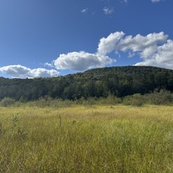
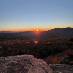
The Burnt Knob Loop leads to the summit of Windham High Peak with a gorgeous view, roughly ~7 miles of hike with beautiful scenery all around. The loop is a bit of a misnomer since the hiking trail itself connects two separate trail heads via two parking lots. One side of the trail shares a parking lot with the trail to Blackhead mountain summit and the two trails goes in separate directions at about 1 mile into the hike. The connection between the two hikes allows one to extend either trail further. We didn't go to the blackhead trail, since it was marked to be difficult to very difficult. The burnt knob loop was a moderate hike, we parked our car at the parking lot shared with blackhead trail and the roundtrip to and from the summit (~3.5 mile) took about 4.5 hours with breaks for lunch on top of the Peak. The trail itself was well designed and very enjoyable, offering numerous view points with spectacular views of mountains and the grassland below. The trail markers are very clearly defined from one to the other, and instead of having continuous steep elevation, it interchanges between longer periods of flat trails and short intervals of arduous elevated trails. It was almost like interval training! This really modulates the pace of the hike, after heart pounding climbs, there are enough time to recover with a period of easy going trails. There are many view points along this trail leading up to the summit, which offers very different and beautiful views. At the summit, the shadows of the clouds on the fields and the beautiful flat grasslands with side views of mountains are absolutely stunning, we spent a lot time lazying around here before heading back down. Highly recommended to all nature lovers looking for some great hike with beautiful views! read more


More info about Windham High Peak - Burnt Knob Loop
Maplecrest, NY 12454
Directions
Hours
Outdoor Amenities


Windham High Peak - Burnt Knob Loop - hiking - Updated June 2026
Best of Maplecrest
People found Windham High Peak - Burnt Knob Loop by searching for…
Hiking Trails in Maplecrest, New York
Things to Do in Maplecrest, New York
Easy Hikes in Maplecrest, New York
Scenic Overlook in Maplecrest, New York
Beautiful Views in Maplecrest, New York
View Points in Maplecrest, New York
Scenic Views in Maplecrest, New York
Hiking With Kids in Maplecrest, New York
Walking Trails in Maplecrest, New York
Waterfalls in Maplecrest, New York
Parks for Kids in Maplecrest, New York
Kid Friendly Hiking Trails in Maplecrest, New York
Lookout Points in Maplecrest, New York
Running Trails in Maplecrest, New York
Scenic Spots in Maplecrest, New York
Trails in Maplecrest, New York
Waterfalls and Swimming Holes in Maplecrest, New York
Romantic Views in Maplecrest, New York
Off Road Trails in Maplecrest, New York
Off Leash Dog Hikes in Maplecrest, New York
Browse Nearby
BEST of Maplecrest, New York Restaurants near Windham High Peak - Burnt Knob Loop
BEST of Maplecrest, New York Things to Do near Windham High Peak - Burnt Knob Loop
BEST of Maplecrest, New York Parks near Windham High Peak - Burnt Knob Loop
BEST of Maplecrest, New York Coffee near Windham High Peak - Burnt Knob Loop
BEST of Maplecrest, New York Campgrounds near Windham High Peak - Burnt Knob Loop
BEST of Maplecrest, New York Breakfast near Windham High Peak - Burnt Knob Loop
BEST of Maplecrest, New York Lakes near Windham High Peak - Burnt Knob Loop
BEST of Maplecrest, New York Ski Resorts near Windham High Peak - Burnt Knob Loop
BEST of Maplecrest, New York Taxis near Windham High Peak - Burnt Knob Loop
Browse Brands
Browse Articles
People who viewed Windham High Peak - Burnt Knob Loop also viewed
Hunter Mountain Hiking Trail
4 reviews
The Windham Path
14 reviews
Kaaterskill Clove
2 reviews
George V Vanderbilt Park - Greenville Town Park
4 reviews
Greenport
5 reviews
Angelo Canna Town Park
3 reviews
Stockport-Greenport Trail
1 review
Scenic Hudson's Long View Park
1 review
Mawignack Preserve
1 review
Dutchman’s Landing Park
6 reviews