Cancel

    Open app

    Search

    Horseshoe Trails

    3.0 (2 reviews)
    Open Open 24 hours

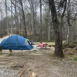
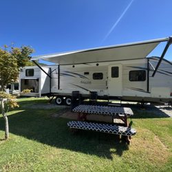
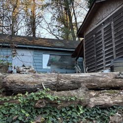
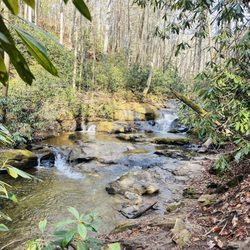
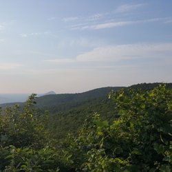
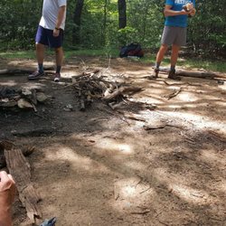
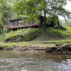
    Horseshoe Trails Photos

    You might also consider

    Recommended Reviews - Horseshoe Trails

    Your trust is our priority, so businesses can't pay to alter or remove their reviews. Learn more about reviews.
    Yelp app icon
    Browse more easily on the app
    Review Feed Illustration

    1 year ago

    Helpful 0
    Thanks 0
    Love this 1
    Oh no 0

    6 months ago

    Helpful 1
    Thanks 1
    Love this 0
    Oh no 1

    Verify this business for free

    People searched for Campgrounds 277 times last month within 15 miles of this business.

    Verify this business

    Old Vinings Inn - Fried Chicken with grits and collard greens

    Old Vinings Inn

    3.8(274 reviews)
    66.3 mi
    $$

    My family and I are Vinings locals who love OVI. Favorites include the roasted beet salad, braised…read moreshort rib, garlic green beans, mac and cheese, and the bread pudding dessert. But this review, I must write about the amazing service. It's not limited to the dining room, folks. Recently I picked up dinner for my family, but my car's (new!) battery died in the parking lot. What the heck? I was stuck. I popped into OVI to let staff know my car would be there until we could fix it. The general manager, Tara, immediately offered a jump. She went above and beyond to help me get to the battery, which wasn't under the hood after all. (I was so hungry and overwhelmed, I forgot it is in the back of the car behind the spare tire.) She didn't care about getting her hands dirty or all the time she was spending on me. Nope, she didn't bat an eye. Calm and collected, she knew exactly what to do and quickly got my car started. What a lifesaver! Old Vinings Inn has good food and GREAT people!

    Attended a baby shower at this very cute and quaint location. We had a private room which allowed…read morefor us to have lots of fun with games and not worry about noise levels. The serving team was fun with a good sense of humor and even helpful when we were struggling with games. There were options for everyone with the brunch menu and the bread basket and cheese grits were some of the highlights. The crabcakes were also good. The flourless chocolate cake for dessert was decadent. Would definitely book another special event at this location.

    Photos
    Old Vinings Inn - Interior

    Interior

    Old Vinings Inn - Dinner rolls with sea salt and sweet cream butter

    Dinner rolls with sea salt and sweet cream butter

    Old Vinings Inn - Interior

    See all

    Interior

    Smithgall Woods - Angel of Death Mushroom along the trail - one of the most poisonous in the world

    Smithgall Woods

    4.8(10 reviews)
    3.3 mi

    Venue Smithgall Woods State Park ( Smithgall Cottages) 5 out of 5 stars…read more After copious amounts of research and several venue tours, we decided on Smithgall Woods state park, and more specifically the cottages as the venue for our wedding on June 8th. We just have to say we loved the team we worked with at Smithgall, mainly Todd, Patty, and Art. Todd at Guestservices was simply fantastic! As he will be quick to mention "the venue sells itself", however having him as our man on the inside was a pretty huge selling point on its own. He was with us every step of the way to answer our plethora of questions, work with vendors, and generally keep our minds at ease. Honestly, I doubt the wedding weekend would have gone as smoothly and been as much of a success had it not been for Todd's guidance and cooperation. The venue is magical. I know how that sounds, but it's the truth. It's tucked away deep in the beautiful North Georgia mountains, surrounded by a lush forest teaming with wildlife. This majestic property consists of five "cottages", in quotations because they are more like log cabin style mansions. The two largest being; the expansive 4 bedroom 4.5 bathroom cottage called the Smithgall Cottage, and the even larger 5 bedroom 5 bathroom Dover cottage. The Creekside Cottage is 3 bedrooms, and The Laurel and Garden cottages are one bedroom cottages with hot tubs on secluded side porches. All the cottages were clean, modern, and a huge hit with our guests. We were able to house both our families, close friends and wedding party all on the same property. Which saved us a great deal on lodging. Which after factoring in the cost of rooms made this one of the more affordable wedding venues out there. Also you get it for the whole weekend!!! We used the Smithgall Cottage for our wedding location due to the large wrap around porch and decks, and also due to the picturesque, covered foot bridge under which flows a gorgeous champion trout stream. We had some difficulty deciding where on this property to hold our ceremony because it is simply lovely all over. Unfortunately, the record rainfall that weekend made the decision for us. Even though the storms limited our use of the enormous field in front of the Dover cottage, and the gardens next to Smithgall we still were able to comfortably host our 50 or so guests and dozen vendors, at the Smithgall Cottage and our ceremony and reception went along wonderfully. We would highly recommend this venue to anyone wishing to have a once in a lifetime event at a once in a lifetime location.

    I came here to see the covered bridge, but discovered they have so much more…read more THE SCENE Smithgall Woods may not be someplace Georgians are familiar with, unless you are an avid hunter or trout fisherman. It was once private property that was gifted to the state by conservationist Charles A. Smithgall Jr. in 1994. A large section still remains private property for the Smithgall family, but what was gifted is a treasure trove of beautiful mountains, streams, meadow fields and wetlands. I began my solo hike around 12:15pm from the Visitors Center. There I was given a map and a few brief highlights of points of interest, like the waterfalls and gold mine. I then set off one what turned out to be a 4.5 hour adventure. Probably not the smartest of ideas since I had surgery just three weeks ago. But I was tired of resting around the house and desperately wanted to get out and do something. Besides, nature brings a calmness to my inner being and allows me to relax my mind in ways I just can't at home. It was a perfect day with perfect temperatures for hiking. In my entire time there, I only ran across one other human. ----- THE HIKE Inside the Visitor's Center is a gift shop and small wildlife museum of the nature plants and animals. I walked down the paved Tsalaki Trail towards the Cathy Ellis Trail (approximately 2.6 mile away). The trail starts off as a fairly steep incline. Along the way I saw a sign saying "caution - bees". I thought that was a curious warning until I noticed the white honey bee houses in the woods nearby. Next came the wetlands with a one mile looping trail and a boardwalk into the marshes. Here you have a strong possibility of seeing a beaver at work on a dam. I decided to save this area for my return hike and I'm glad I did. My energy on the return leg was running very low and I needed the benches here for a nice long rest. I reached the covered bridge about 37 minutes after leaving the visitors center. It was a real beauty made in the simple Town Lattice style. The memorial plaque at the entrance was titled "Bay's Bridge In loving memory of 'Bay' Elizabeth Smithgall Watts", whom died the year the land for the state park was gifted. It crosses the amazing mountain stream known as Duke's Creek. The creek from here will be a large part of your journey. The trail turns to gravel just past the bridge. MARTIN'S MINE was one of the first Gold mines in Georgia. Most of the mining occurred from 1829 to 1935. By the 1840's most of the easy gold was gone and hard mining began. Miners dug tunnels and shafts to remove ore from deep underground. You can still see some of the entrances and shafts. The trail is well marked with numbers, so be sure to pick up the Mining Trail brochure at the Visitor's Center to help you decode the locations. There is a spur trail off the Martin's Mine loop that takes you to a waterfall used for hydraulic mining, which began in the 1850's. It is an uphill hike, but the waterfall is very nice. Back on the main trail I traveled another 1/2 mile to Cathy Ellis Trail. This 1/2 mile trail starts off uphill, but once you reach the shelter it's all downhill from there. The trail ends at the beautiful Chunannee waterfall (which means friendship). Lots of vegetation on this portion of the hike. This land was once the home of Lucy Bryant, a Cherokee Indian widow whom was granted this 640 acre parcel in the Treaty of 1817. But by 1839 the Trail of Tear forced all Cherokee Indians off their land to relocate in Oklahoma. They curiously chose to name the trail after a 19 year old girl who fell over a waterfall in a different county altogether instead of the Indian widow Lucy. I don't get that, but whatever. The waterfall here is beautiful. I sat here about 25 minutes resting and admiring its beauty and feeling sad for the ancient Cherokee Indian nation. I arrived here approx. 2.5 hours after I began my journey from the visitors center. NOTE: Prior to arriving at the Cathy Ellis trail there is another steep incline, similar to the one near the Visitor's Center. ----- FINAL THOUGHTS In total I hiked approximately 7.5 miles today. I would normally have done this in probably 3 hours, but I tried to go at an easier pace since I'm still recovering from surgery. I allowed myself plenty of places to sit and rest, the most enjoyable of them being the waterfall on the Cathy Ellis Trail. Smithgall Woods State Park is indeed a wonderful place for those who love nature and peaceful hiking venues. I HIGHLY RECOMMEND giving them a visit.

    Photos
    Smithgall Woods - Beautiful state park

    Beautiful state park

    Smithgall Woods - Visitor's Center

    Visitor's Center

    Smithgall Woods - Bay's Covered Bridge

    See all

    Bay's Covered Bridge

    Hogpen Gap - Overview before hiking Hogpen Gap

    Hogpen Gap

    4.5(2 reviews)
    4.1 mi

    If you plan to tackle the Appalachian Trail, head on over to Hogpen Gap. Between 13 and 14 miles is…read morethe distance for it. Some people have told me 13.4 miles, others say 13.8, I just say 14 and round it off. This is one way. I would suggest you either have a friend who parked at Unicoi Gap and drive with you to Hogpen Gap so you both could hike it. Otherwise, remember you have to walk back to your car afterwards so that's 14 x 2 = 28 miles. Hogpen Gap does has its own parking lot, so does Unicop Gap. Honestly, I would've never thought to tackle this trail without the support of my job. We were walking for a charity event and each miles per person = a dollar donation for Gigi's Playhouse. You can see it all on the news here, our journey. The video is here http://www.fox5atlanta.com/recipebox/270043868-video The article is here http://www.fox5atlanta.com/good-day/269973657-story I just want to say kudos to those who want to tackle the AT!! It is rough in some areas. Overall, the trail is moderate but some parts are strenuous with inclines of boulders. There are areas for camping and water (literally water running down the stream, many take filter water bottles). We actually met a lady who was doing the trail solo and camping. I find it amazing that people do have that passion. Honestly, I can proudly say that I've done this trail. It was tough in the past few miles. I was okay up until 11.5 miles. After that, my legs felt like jello. It took roughly 7.5 hours to finish it. More than halfway on the trail, you can see the birth of the Chattahoochee River, from a small stream that heads towards Atlanta. Whoever thought! Stay on the white trail. If you see a blue trail, it means it's an off trail. The white trail means you're still on the AT. If you see two double white lines, it means you will make a sharp turn. 103/2017

    Trail effing Magic!…read more Ron of Ron's Appalachian Trail Shuttle and other Friends of the AT leave fresh clean water at the Gap. It's also a nice paved area to park your car and go for a day hike. If you're section or thru hiking, about a halfish mile or so south is a natural shelter. Several large rock formations that you can seek shelter under or setup a small tent under to get out of the wind or rain. I did and it was absolutely amazing. If you set a campfire the boulders vector the smoke perfectly to make a smoke blanket for warmth if you get your tent set properly with ventilation and all. I was warm all night (late October) with embering logs overnight. Another bonus of this gap; IF you need a break from the roughness of the trail(heading south) the highway will bring you back to it at Testanee Gap. Park, take a hike. Well with it.

    Photos
    Hogpen Gap - Rest area, lunch/snack time

    Rest area, lunch/snack time

    Hogpen Gap - Overview before hiking Hogpen Gap

    Overview before hiking Hogpen Gap

    Hogpen Gap - Blue trail, means off trail

    See all

    Blue trail, means off trail

    Mount Yonah Trailhead - Turkey Tail Mushrooms along the trail

    Mount Yonah Trailhead

    4.7(37 reviews)
    4.2 mi

    This is a separate mountain that isn't park of any of the massive park areas in the Appalachians…read morenearby. The trailhead is at the end of a short gravel road that was bumpy; navigable with a sedan but not ideal. The hike is woodsy and not highly difficult, but the cumulative effect after a couple of miles is significant. I found a meadow short of the peak which was sufficient for my interest. It had some nice views. Wildlife included a woodchuck and a substantial snail population. This area was considerably less crowded than the bigger mountains or the tourist town nearby. It wasn't anything mind-blowing, but it's a good outdoor activity.

    The trail is only 2 miles long, but small part of it can be considered easy, most parts are rocky,…read moresome parts are steep. Normal trails take me 20 minutes for a mile, but this time it took me 80 minutes to get to the top. But reward is the beautiful views at the top. There are many tents and hammock setups at the small flat area on the peak. There are many branches along the trail with no sign, which are normally various shortcuts to the top, usually means steep, stay on trail with green marks. People were doing all kinds of yoga posting on the edges of rocks, it's nice but I personally don't think it worth the risk. Parking lot is small, expect to park along the way to trailhead. People brought climbing gears and lined up for serious climbing. According to a sign, this also is US military climbing training area.

    Photos
    Mount Yonah Trailhead - Along the trail

    Along the trail

    Mount Yonah Trailhead
    Mount Yonah Trailhead - Fall Views

    See all

    Fall Views

    Horseshoe Trails - campgrounds - Updated May 2026

    Loading...
    Loading...
    Loading...