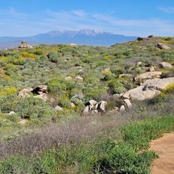
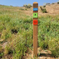
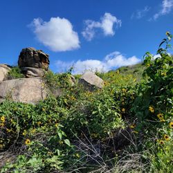
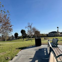
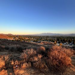
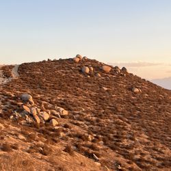
Hidden Valley Wildlife Area Photos


You might also consider
More like Hidden Valley Wildlife Area
Recommended Reviews - Hidden Valley Wildlife Area
Start your review...

10 days ago
It seems this wildlife area has been left to die. When you first walk in from the parking area the grass is green and the area is very nice so they get a 1 star. When you walk down the very slippery hill to the wetland area it is all overgrown, the paths are full of weeds and downed branches for the trees. It needs to be cleaned up as right now it's all a fire hazard. Yes there is wildlife we saw squirrels and birds and hawks but the walking paths are so overgrown there are probably snakes hiding in the weeds. The water that is supposed to be there is full of weeds and debris. Please clean up what could be a great place for learning about nature read more


13 years ago
Definitely great way to start your morning. Unwind a clear head enjoy nature. One of the few places still left where you can actually view wildlife so close to home!! read more
More info about Hidden Valley Wildlife Area
11401 Arlington Ave
Riverside, CA 92505
Directions
(951) 785-7452
Call Now
Hours
Outdoor Amenities
You might also consider


Why does Yelp recommend reviews?
1 review that is not currently recommended
The reviews below are not factored into the business's overall star rating.
15 years ago
Hidden Valley Wildlife Area - hiking - Updated May 2026
Best of Riverside
People found Hidden Valley Wildlife Area by searching for…
Beautiful Views in Riverside, CA
Things to Do With Kids in Riverside, CA
Hiking Trails in Riverside, CA
Camping Sites in Riverside, CA
Free Things to Do in Riverside, CA
Hiking With Kids in Riverside, CA
Secluded Spots in Riverside, CA
Walking Trails in Riverside, CA
Running Trails in Riverside, CA
Trending Searches in Riverside, CA
Boat Rental near Hidden Valley Wildlife Area
Botanical Gardens near Hidden Valley Wildlife Area
Bounce House Rentals near Hidden Valley Wildlife Area
Campgrounds near Hidden Valley Wildlife Area
Cheap Plants near Hidden Valley Wildlife Area
Cherry Picking near Hidden Valley Wildlife Area
Cliff Jumping near Hidden Valley Wildlife Area
Flower Fields near Hidden Valley Wildlife Area
Flower Shop near Hidden Valley Wildlife Area
Garage Sales near Hidden Valley Wildlife Area
Garden Center near Hidden Valley Wildlife Area
Lakes & Ponds near Hidden Valley Wildlife Area
Nurseries & Gardening near Hidden Valley Wildlife Area
Outdoor Activities near Hidden Valley Wildlife Area
Outdoor Furniture Stores near Hidden Valley Wildlife Area
Parks near Hidden Valley Wildlife Area
Party Equipment Rentals near Hidden Valley Wildlife Area
Pedicure near Hidden Valley Wildlife Area
Photo Spots near Hidden Valley Wildlife Area
Picnic Areas near Hidden Valley Wildlife Area
Places To Take Pictures near Hidden Valley Wildlife Area
Rock Quarry near Hidden Valley Wildlife Area
Running Trails near Hidden Valley Wildlife Area
Rv Rental near Hidden Valley Wildlife Area
Scenic Drive near Hidden Valley Wildlife Area
Sunrise View near Hidden Valley Wildlife Area
Swimming Holes near Hidden Valley Wildlife Area
Table And Chair Rentals near Hidden Valley Wildlife Area
Browse Articles
Browse Nearby
BEST of Riverside, California Coffee near Hidden Valley Wildlife Area
BEST of Riverside, California Things to Do near Hidden Valley Wildlife Area
BEST of Riverside, California Restaurants near Hidden Valley Wildlife Area
BEST of Riverside, California Breakfast near Hidden Valley Wildlife Area
BEST of Riverside, California Walking Trails near Hidden Valley Wildlife Area
BEST of Riverside, California Parks near Hidden Valley Wildlife Area
BEST of Riverside, California Campgrounds near Hidden Valley Wildlife Area
BEST of Riverside, California Hotels near Hidden Valley Wildlife Area
Browse Brands
Related Searches in Riverside, CA
Best Fishing Locations and Guides in Riverside, California
Best Nature Trails for Hiking in Riverside, California
Best Places for Horseback Riding in Riverside, California
Best Sledding Spots and Fun in Riverside, California
Best Waterfalls and Swimming Holes in Riverside, California
Check Out Off Road Trails in Riverside, California
Discover Dog Friendly Trails to Explore in Riverside, California
Discover Kid Friendly Hiking Trails in Riverside, California
Discover Scenic Waterfall Spots in Riverside, California
Discover Top Nature Parks to Visit in Riverside, California
Discover Walking Parks in Riverside, California Near You
Discover a Hiking Trail in Riverside, California
Discover the Best Night Hike Trails in Riverside, California
Dog-Friendly Hikes With Dogs in Riverside, California
Enjoy Camping Adventures Around Riverside, California
Enjoy Exciting Mountain Biking Adventures in Riverside, California
Enjoy Kayaking Adventures in Riverside, California
Enjoy Tent Camping Spots Around Riverside, California
Enjoy a Beautiful Waterfall Hike in Riverside, California
Enjoy a Peaceful Nature Walk in Riverside, California
Enjoy the Best Picnic Spots and Ideas in Riverside, California
Enjoy the Best Walking Path in Riverside, California
Enjoy the Best Walking Trails in Riverside, California
Exciting Cliff Jumping Spots in Riverside, California
Explore Beautiful Parks and Green Spaces in Riverside, California
Explore Easy Hikes Perfect for All in Riverside, California
Explore Fun Activities to Do in Riverside, California
Explore Popular Campgrounds Near Riverside, California
Explore the Best Beach Spots in Riverside, California
Explore the Best Swimming Holes Around Riverside, California
Explore the Best Trail Options in Riverside, California
Family Friendly Hiking With Kids in Riverside, California
Find Popular Ziplining Spots Around Riverside, California
Find the Best Parks for Picnics in Riverside, California
Find the Best Scenic View Locations in Riverside, California
Great Places to Walk in Riverside, California
Hiking Trails With Waterfalls in Riverside, California
Off Leash Dog Hiking Trails in Riverside, California
Plan a Scenic Drive Route Near Riverside, California
Popular Outdoor Activities to Try in Riverside, California
Popular Picnic Spots to Visit in Riverside, California
Safe River Swimming Areas in Riverside, California
Safe and Fun Parks for Kids in Riverside, California
Top Climbing Spots and Gyms in Riverside, California
Top Places for Snorkeling in Riverside, California
Top Running Trails to Explore in Riverside, California
Top Swimming Lakes to Enjoy in Riverside, California
Top Swimming Spots and Pools in Riverside, California
People who viewed Hidden Valley Wildlife Area also viewed
Santa Ana River Trail - Hidden Valley Wildlife Reserve Entrance
27 reviews
Hidden Valley Wildlife Area
15 reviews
Challen Hill Park
12 reviews
Tin Mine Canyon Trail
9 reviews
Eastvale Trail
17 reviews
Fresno Canyon Trail
10 reviews
Martha McLean - Anza Narrows Park
15 reviews
Jameson Park
13 reviews
La Sierra Park
8 reviews
Spyglass Park
4 reviews