Evans Creek Trailhead Photos


You might also consider
More like Evans Creek Trailhead
Recommended Reviews - Evans Creek Trailhead
Start your review...

Reviews With Photos

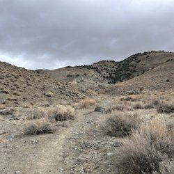
Discovered this hiking area last year when Yelp hosted the Outdoor Explorers series. Frustrated with staying home during the covid, the pup and I have decided to explore outside our neighborhood. This hiking area is perfect for spring and fall. Ninety five percent of it has no shade. It's mostly rocky hill and mountainsides covers with sagebrush and cool rock outcroppings. In the lower valley are a few trees clinging to the creek's edge for water. By afternoon the slopes can get quite windy. There are actually three main trails with several markers laying out each one and where they share paths. I have really learned to enjoy and finally understand the app called AllTrails. Just hit the map in the upper right corner and it shows you where you are and all the nearby trails, and if you have wandered off your intended path. Most paths are shared by hikers, runners and dog walkers. There is a leash law but seriously I was the only one obeying it. You're also supposed to pick up and carry out after your dog. Some trails are also used by horse riders and bicyclists. So be aware of fast traffic from behind. Certain trains are very narrow and can run the edge of the canyon, others are wide enough for a truck to drive on. They also vary from soft sandy to hard sharp rocky trails. Currently during the covid there are extra signs pointing out trails that are too narrow for social distancing and green trails that give everyone plenty of safe space. Get out and enjoy some sunshine, exercise and nature. And take the furry baby, they are tired of you being home all the time too.

This is my go to hike in town. It is just north of the University and you can't miss the giant "N". I probably do this one at least once a week. I love the elevation climb with a bit of flat in spots. Definitely will get your heart rate up with the climb. There are lots of trails off this one made for bikes and hikers as well as a disc golf. You can park a couple places depending on how long you want the walk to be. If you park at the dog park there is a tunnel that will take you under McCarren and a nice stroll through trees on the first half. You can also park at the sports complex and start there. In this case you will pass by the Basque monument at the beginning, a brief section of trees, then on to the wide openness with the view of the N. Bring some water and a love of the outdoors while you view quintessential northern nevada landscape on a walk up to the N. Also note there are no trash bins along the walk, so take out what you bring in. If you bring a pet, please for peoples sake pick up after your pet and take it with you!! Please don't leave the bags for the "way back".

The quintessential Northern Nevada hike showing off our natural habitat, flora, and fauna! Best part is it's super close to the city. The trial is located just north of the university, and it winds its way around the hills which overlook downtown Reno, with the creek running g down the valley. Sagebrush, wild flowers,and other native plant life abounds. It was super fun to watch for new species of plants along the trail, and if you have a knowledgeable friend great at identifying plants, you could really learn something here. The trail is fairly levels the whole way. It was an easy 3 mile loop from the parking area, past the monument and back. The first half of the trail was partially shaded until we reached the outlet where the water was coming into the creek. From there though, it was all sun all the time. Views are great the whole way. Going up the valley, you're looking at a neighborhood, but when you double back you get some fantastic views of the city. All in all it's a nice hike, great for all abilities, dog friendly and very representative of Northern Nevada high desert. The drawbacks are only the lack of shade on the trail, but of you start early, you'll be done before it heats up!

I come here regularly to run this trail, and every time I learn something new about it. The trail starts through rancho, and ties in with different routes such as nature trail and poedunk trail. I run this trial, but hikers/bikes are on the trail as well, and the whole loop is about 8 miles if I cut it short upper Evan's is about 5-6 miles. The views at the top make the push up hill worth it. I'd recommend bringing proper hydration due to a lot of sun exposure, and length of the trail. This will always be my first choice as to what trail to run in Reno, and rate this my favorite trail in Reno!

My husband and I hiked the Miners Trail to the N one spring morning, and we were glad we were there before noon and not in summer! There is brief shade just after starting along the trail, but for the most part, it's you and the sun. When we reached the N, there was a log perfect for perching and enjoying lunch we'd brought. (Well, brunch because it thankfully didn't take as long as I'd thought! Haha!) When we hiked down, we continued on our path instead of taking the same path down so that we made a loop. I'm not a fan of going downhill, so I found it to be definitely steep... eepers! My husband (per our usual) was fine, however. Our puppy could be mostly off-leash, but we did pick her up as we passed people. We did decide that we'd take the kids (3, 7, 8, and 9) perhaps one evening after the hottest part of the day. They totally could have made this one!

If you live in Reno and haven't hiked up to the "N" yet, what are you waiting for? This is a great little workout with a somewhat steep incline that gets you some of the best views in town! Bring your dog and water bottle, park at the Rancho San Rafael dog park and start walking! This time of year is especially nice because, while you would not expect it from looking at the "N" from McCarran and the surrounding desert terrain, there is a beautiful, natural, lush bird sanctuary on the north side of the McCarran tunnel. The sound of Evans Creek flowing combined with the songs of a variety of different birds make you feel like you are not in Reno. You will catch glimpses of gorgeous birds, like the black-billed magpie, in flight- a beautiful thing to witness!

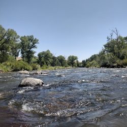
Winter is ending, and summer will be here before you know it! It's time to get your game on! Grab those hiking boots, clear out the cobwebs, and take a hike! The trails here along Evans Creek are awesome! You can choose several ways to go, and make it as easy or as difficult as you want. I personally like to hike up the creek on one side, and then hike back down on the other side. It's a great place to take the dogs, and a date! I love taking my wife up there! There is also an interpretive trail, with signs containing information about the creek, the area, the animals, and the different variety of plants in the canyon. When entering the area, there are also signs warning about invasive species that are growing in the canyon. The sad thing is, these weeds are growing everywhere up there! Star thistle is one of them! Very thorny, and very invasive! Every time I walk through there, I try to pull up a few, but you really need to have good gloves on to do so. Take a hike up to the letter "N", and take in the view! You will not be disappointed! So, grab the dogs, the leashes, and your partner, and take a hike! There are many places to hike around Reno. This trail is wonderful. Evans Creek flows year 'round! You can even take your mountain bike for a ride up there on the trails, and many folks run it, I just walk it! See you there!

If what you're looking for is a quick hike, close to the city, with lots of options, then this is perfect. Many different options for the hiker with a small to zero chance of getting lost. McCarran is always near by to help you find your way back to the car. You can hike up to the "N", you can connect to the Miner's Trail in nice little canyon, or you can just wander around on the creek trails (creek is typically dry unless recent precipitation came down). There's also a nice frolf course throughout the park if that's your thing.

So surprised this trail only has 3 reviews so far! I'm new to the area and wanted to find a hike near home- wowee did I find it! Smack dab in the middle of Reno is this big glorious park with spacious views and surprisingly well-kept trails! The Evans trailhead has a map with laid-out trails and names for each ranging from, in layterms, "pretty easy" to "almost hard"! It's got shade and sun alike, the Evans creek flows through, and if you have a dog or just like looking at them (?), this trail leads to a dog park if you just take a tunnel under McCarran!

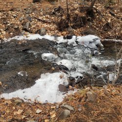
Nice, relatively easy trail. Plenty of parking on site, and there's a porta-potty at the trailhead. Open to hikers, trail runners and mountain bikers. Pets are welcome as long as they are on leash and you pick up after them! I've been here twice, once during spring when it was muddy, and more recently, at the beginning of summer, when it's hot and dry. I enjoyed both times. I'm not sure how uncomfortable it can be when it's the height of summer. There's hardly any shade on the trail, so just make sure you are properly prepared for the sun when you are out there. Also, some forks do not necessarily have signs, so could be tricky on which turn to take. But, on the bright side, it's all flat, so you can always kind of see which direction you need to head to. Also, this trail intersects other longer or shorter trails, so you can pick which one you're feeling up to taking at any given day. Overall, a great trail to hike. Enjoy and happy trails!

I.love.this.place. I found this place in my A foot and A field Reno/Tahoe hiking guide. It's gorgeous. It's Clean. It has mapped out little trails. All types of people come here to walk,run or play disk golf. If you walk to the other side there is a tiny little lake where ducks hang out, and you can also fish. And beyond that is a tiny area dedicated to the Euro Basque. I'm assuming during spring/summer hours there will be animals in the cages, I only saw turkeys and chickens. This has been my go to place to let off steam and breath in the fresh air when you need a moment away from people and can't make the drive to a Tahoe trail.

The best place to park (other than off McCarran) is at the Reno Sports Complex - 2975 N. Virginia Street Reno, NV. Then hike up past the Basque Monument an down towards the Nature Trail. Go North and you will see the sign for the trail. The trail is excellent for dogs to go off leash and there is water available about seven months out of the year. The lower trail is about a three mile loop and has offshoots to other trails and the Nevada "N". It is a popular trail for hikers, bikers, and dogs.

loop variations of 2.2 and 3.4 miles easy to moderate hike...... Ok I'm a FAN of this trailhead...... 1. because it's so close to my house. 2. Because of the views 3. Many different trailheads lead off of this one 4. The cute bridges that you come across 5. The wildlife down by the creek 6. It's not a hard hike either.... Next time I'll come earlier and hike up to the "N" And I'll bring my misquote replant witch you'll need down by the creek....... Bring water and doggy poop bags if you bring your furry friend with you. :)

1 year ago
This is the first trail that I went to when I first moved to Reno many years ago. It was Fall and I took the most amazing pictures on the Nature Trail, like something out of a fairy tale. Coming in the Winter is quite a different story as everything is leafless and dry, so I decided to venture out into the canyon. There are so many possibilities for exploration, but limited on time, I decided on a quick loop up the Rancho Connector. It was a steady incline, but worth the views of downtown and nearby snow-capped mountains. Awesome time! If you are looking for a hike that is easily accessible and has a diverse trail system, come check it out. Also worth the mention is The National Monument to the Basque Sheepherder just past the trailhead. read more


 in the Nature Trail. - Hiking Near Me - Reno, Nevada")


1 year ago
Great nature trail hike. Porta potty at the entrance, if you need one. Depending on path slope can be a little bit rocky so careful walking down. read more


8 months ago
Discovered this hiking area last year when Yelp hosted the Outdoor Explorers series. Frustrated with staying home during the covid, the pup and I have decided to explore outside our neighborhood. This hiking area is perfect for spring and fall. Ninety five percent of it has no shade. It's mostly rocky hill and mountainsides covers with sagebrush and cool rock outcroppings. In the lower valley are a few trees clinging to the creek's edge for water. By afternoon the slopes can get quite windy. There are actually three main trails with several markers laying out each one and where they share paths. I have really learned to enjoy and finally understand the app called AllTrails. Just hit the map in the upper right corner and it shows you where you are and all the nearby trails, and if you have wandered off your intended path. Most paths are shared by hikers, runners and dog walkers. There is a leash law but seriously I was the only one obeying it. You're also supposed to pick up and carry out after your dog. Some trails are also used by horse riders and bicyclists. So be aware of fast traffic from behind. Certain trains are very narrow and can run the edge of the canyon, others are wide enough for a truck to drive on. They also vary from soft sandy to hard sharp rocky trails. Currently during the covid there are extra signs pointing out trails that are too narrow for social distancing and green trails that give everyone plenty of safe space. Get out and enjoy some sunshine, exercise and nature. And take the furry baby, they are tired of you being home all the time too. read more


4 years ago
This is my go to hike in town. It is just north of the University and you can't miss the giant "N". I probably do this one at least once a week. I love the elevation climb with a bit of flat in spots. Definitely will get your heart rate up with the climb. There are lots of trails off this one made for bikes and hikers as well as a disc golf. You can park a couple places depending on how long you want the walk to be. If you park at the dog park there is a tunnel that will take you under McCarren and a nice stroll through trees on the first half. You can also park at the sports complex and start there. In this case you will pass by the Basque monument at the beginning, a brief section of trees, then on to the wide openness with the view of the N. Bring some water and a love of the outdoors while you view quintessential northern nevada landscape on a walk up to the N. Also note there are no trash bins along the walk, so take out what you bring in. If you bring a pet, please for peoples sake pick up after your pet and take it with you!! Please don't leave the bags for the "way back". read more

7 years ago
The quintessential Northern Nevada hike showing off our natural habitat, flora, and fauna! Best part is it's super close to the city. The trial is located just north of the university, and it winds its way around the hills which overlook downtown Reno, with the creek running g down the valley. Sagebrush, wild flowers,and other native plant life abounds. It was super fun to watch for new species of plants along the trail, and if you have a knowledgeable friend great at identifying plants, you could really learn something here. The trail is fairly levels the whole way. It was an easy 3 mile loop from the parking area, past the monument and back. The first half of the trail was partially shaded until we reached the outlet where the water was coming into the creek. From there though, it was all sun all the time. Views are great the whole way. Going up the valley, you're looking at a neighborhood, but when you double back you get some fantastic views of the city. All in all it's a nice hike, great for all abilities, dog friendly and very representative of Northern Nevada high desert. The drawbacks are only the lack of shade on the trail, but of you start early, you'll be done before it heats up! read more


5 years ago
I come here regularly to run this trail, and every time I learn something new about it. The trail starts through rancho, and ties in with different routes such as nature trail and poedunk trail. I run this trial, but hikers/bikes are on the trail as well, and the whole loop is about 8 miles if I cut it short upper Evan's is about 5-6 miles. The views at the top make the push up hill worth it. I'd recommend bringing proper hydration due to a lot of sun exposure, and length of the trail. This will always be my first choice as to what trail to run in Reno, and rate this my favorite trail in Reno! read more


My husband and I hiked the Miners Trail to the N one spring morning, and we were glad we were there before noon and not in summer! There is brief shade just after starting along the trail, but for the most part, it's you and the sun. When we reached the N, there was a log perfect for perching and enjoying lunch we'd brought. (Well, brunch because it thankfully didn't take as long as I'd thought! Haha!) When we hiked down, we continued on our path instead of taking the same path down so that we made a loop. I'm not a fan of going downhill, so I found it to be definitely steep... eepers! My husband (per our usual) was fine, however. Our puppy could be mostly off-leash, but we did pick her up as we passed people. We did decide that we'd take the kids (3, 7, 8, and 9) perhaps one evening after the hottest part of the day. They totally could have made this one! read more


8 years ago
If you live in Reno and haven't hiked up to the "N" yet, what are you waiting for? This is a great little workout with a somewhat steep incline that gets you some of the best views in town! Bring your dog and water bottle, park at the Rancho San Rafael dog park and start walking! This time of year is especially nice because, while you would not expect it from looking at the "N" from McCarran and the surrounding desert terrain, there is a beautiful, natural, lush bird sanctuary on the north side of the McCarran tunnel. The sound of Evans Creek flowing combined with the songs of a variety of different birds make you feel like you are not in Reno. You will catch glimpses of gorgeous birds, like the black-billed magpie, in flight- a beautiful thing to witness! read more


Winter is ending, and summer will be here before you know it! It's time to get your game on! Grab those hiking boots, clear out the cobwebs, and take a hike! The trails here along Evans Creek are awesome! You can choose several ways to go, and make it as easy or as difficult as you want. I personally like to hike up the creek on one side, and then hike back down on the other side. It's a great place to take the dogs, and a date! I love taking my wife up there! There is also an interpretive trail, with signs containing information about the creek, the area, the animals, and the different variety of plants in the canyon. When entering the area, there are also signs warning about invasive species that are growing in the canyon. The sad thing is, these weeds are growing everywhere up there! Star thistle is one of them! Very thorny, and very invasive! Every time I walk through there, I try to pull up a few, but you really need to have good gloves on to do so. Take a hike up to the letter "N", and take in the view! You will not be disappointed! So, grab the dogs, the leashes, and your partner, and take a hike! There are many places to hike around Reno. This trail is wonderful. Evans Creek flows year 'round! You can even take your mountain bike for a ride up there on the trails, and many folks run it, I just walk it! See you there! read more


8 years ago
If what you're looking for is a quick hike, close to the city, with lots of options, then this is perfect. Many different options for the hiker with a small to zero chance of getting lost. McCarran is always near by to help you find your way back to the car. You can hike up to the "N", you can connect to the Miner's Trail in nice little canyon, or you can just wander around on the creek trails (creek is typically dry unless recent precipitation came down). There's also a nice frolf course throughout the park if that's your thing. read more


7 years ago
10 years ago
So surprised this trail only has 3 reviews so far! I'm new to the area and wanted to find a hike near home- wowee did I find it! Smack dab in the middle of Reno is this big glorious park with spacious views and surprisingly well-kept trails! The Evans trailhead has a map with laid-out trails and names for each ranging from, in layterms, "pretty easy" to "almost hard"! It's got shade and sun alike, the Evans creek flows through, and if you have a dog or just like looking at them (?), this trail leads to a dog park if you just take a tunnel under McCarran! read more


4 years ago
8 years ago
Nice, relatively easy trail. Plenty of parking on site, and there's a porta-potty at the trailhead. Open to hikers, trail runners and mountain bikers. Pets are welcome as long as they are on leash and you pick up after them! I've been here twice, once during spring when it was muddy, and more recently, at the beginning of summer, when it's hot and dry. I enjoyed both times. I'm not sure how uncomfortable it can be when it's the height of summer. There's hardly any shade on the trail, so just make sure you are properly prepared for the sun when you are out there. Also, some forks do not necessarily have signs, so could be tricky on which turn to take. But, on the bright side, it's all flat, so you can always kind of see which direction you need to head to. Also, this trail intersects other longer or shorter trails, so you can pick which one you're feeling up to taking at any given day. Overall, a great trail to hike. Enjoy and happy trails! read more


10 years ago
I.love.this.place. I found this place in my A foot and A field Reno/Tahoe hiking guide. It's gorgeous. It's Clean. It has mapped out little trails. All types of people come here to walk,run or play disk golf. If you walk to the other side there is a tiny little lake where ducks hang out, and you can also fish. And beyond that is a tiny area dedicated to the Euro Basque. I'm assuming during spring/summer hours there will be animals in the cages, I only saw turkeys and chickens. This has been my go to place to let off steam and breath in the fresh air when you need a moment away from people and can't make the drive to a Tahoe trail. read more


The best place to park (other than off McCarran) is at the Reno Sports Complex - 2975 N. Virginia Street Reno, NV. Then hike up past the Basque Monument an down towards the Nature Trail. Go North and you will see the sign for the trail. The trail is excellent for dogs to go off leash and there is water available about seven months out of the year. The lower trail is about a three mile loop and has offshoots to other trails and the Nevada "N". It is a popular trail for hikers, bikers, and dogs. read more


loop variations of 2.2 and 3.4 miles easy to moderate hike...... Ok I'm a FAN of this trailhead...... 1. because it's so close to my house. 2. Because of the views 3. Many different trailheads lead off of this one 4. The cute bridges that you come across 5. The wildlife down by the creek 6. It's not a hard hike either.... Next time I'll come earlier and hike up to the "N" And I'll bring my misquote replant witch you'll need down by the creek....... Bring water and doggy poop bags if you bring your furry friend with you. :) read more


 fall is coming :) - Hiking Near Me - Reno, Nevada")


8 years ago


More info about Evans Creek Trailhead
2975 N Virginia St
Reno, NV 89503
Directions
Hours
Outdoor Amenities
Ask the Community - Evans Creek Trailhead
Review Highlights - Evans Creek Trailhead
You might also consider


Evans Creek Trailhead - hiking - Updated July 2026
Best of Reno
People found Evans Creek Trailhead by searching for…
Beautiful Views in Reno, Nevada
Walking Trails in Reno, Nevada
Scenic Overlook in Reno, Nevada
Places to Take Pictures in Reno, Nevada
Running Trails in Reno, Nevada
Free Things to Do in Reno, Nevada
Off Road Trails in Reno, Nevada
Things to Do Alone in Reno, Nevada
Off Leash Dog Hiking Trails in Reno, Nevada
Trending Searches in Reno, NV
4th Of July Fireworks near Evans Creek Trailhead
Boat Rental near Evans Creek Trailhead
Cliff Jumping near Evans Creek Trailhead
Day Trips near Evans Creek Trailhead
Dog Friendly Trails near Evans Creek Trailhead
Fireworks near Evans Creek Trailhead
Jet Ski Rental near Evans Creek Trailhead
Kayak Rental near Evans Creek Trailhead
Lakes & Ponds near Evans Creek Trailhead
Lookout Points near Evans Creek Trailhead
Mountain Biking near Evans Creek Trailhead
Off Road Trails near Evans Creek Trailhead
Outdoor Activities near Evans Creek Trailhead
Parks near Evans Creek Trailhead
Parks For Picnics near Evans Creek Trailhead
Picnic Spots near Evans Creek Trailhead
Public Pools near Evans Creek Trailhead
Public Shower near Evans Creek Trailhead
River Swimming near Evans Creek Trailhead
Rock Quarry near Evans Creek Trailhead
Scenic Night View near Evans Creek Trailhead
Scenic Overlook near Evans Creek Trailhead
Secluded Spots near Evans Creek Trailhead
Soccer Store near Evans Creek Trailhead
Splash Pad near Evans Creek Trailhead
Star Gazing near Evans Creek Trailhead
Strawberry Picking near Evans Creek Trailhead
Sunrise View near Evans Creek Trailhead
Swimming Holes near Evans Creek Trailhead
Swimming Lakes near Evans Creek Trailhead
U Pick Farms near Evans Creek Trailhead
Watch Sunset near Evans Creek Trailhead
Water Parks near Evans Creek Trailhead
Browse Articles
Browse Nearby
BEST of Reno, Nevada Restaurants near Evans Creek Trailhead
BEST of Reno, Nevada Coffee near Evans Creek Trailhead
BEST of Reno, Nevada Things to Do near Evans Creek Trailhead
BEST of Reno, Nevada Parks near Evans Creek Trailhead
BEST of Reno, Nevada Breakfast near Evans Creek Trailhead
BEST of Reno, Nevada Snow Tubing near Evans Creek Trailhead
BEST of Reno, Nevada Lakes near Evans Creek Trailhead
Browse Brands
Related Searches in Reno, NV
Affordable Bike Repair Services in Reno, Nevada
Affordable Bike Tune Up Services in Reno, Nevada
Affordable Kayak Rental Services in Reno, Nevada
Affordable Tandem Bike Rental in Reno, Nevada
Best Dog Hiking Trails Around Reno, Nevada
Best Electric Bike Rental Services in Reno, Nevada
Best Fishing Locations and Guides in Reno, Nevada
Best Places for Horseback Riding in Reno, Nevada
Best Sledding Spots and Fun in Reno, Nevada
Best Used Bikes for Sale Near Reno, Nevada
Check Out Off Road Trails in Reno, Nevada
Discover Dog Friendly Trails to Explore in Reno, Nevada
Discover Popular Bike Tours in Reno, Nevada
Discover Popular Bike Trails in Reno, Nevada
Discover Scenic Bike Paths in Reno, Nevada
Discover Scenic Mountain Bike Trails Near Reno, Nevada
Discover Scenic Waterfall Spots in Reno, Nevada
Discover a Hiking Trail in Reno, Nevada
Discover the Best Night Hike Trails in Reno, Nevada
Dog-Friendly Hikes With Dogs in Reno, Nevada
Enjoy Biking Adventures Around Reno, Nevada
Enjoy Camping Adventures Around Reno, Nevada
Enjoy Exciting Mountain Biking Adventures in Reno, Nevada
Enjoy Hiking Adventures in Reno, Nevada
Enjoy Kayaking Adventures in Reno, Nevada
Enjoy Tent Camping Spots Around Reno, Nevada
Enjoy a Beautiful Waterfall Hike in Reno, Nevada
Enjoy the Best Picnic Spots and Ideas in Reno, Nevada
Enjoy the Best Tubing Experiences in Reno, Nevada
Enjoy the Best Walking Path in Reno, Nevada
Enjoy the Best Walking Trails in Reno, Nevada
Exciting Cliff Jumping Spots in Reno, Nevada
Experience Thrilling White Water Rafting in Reno, Nevada
Explore BMX Bike Shops Near Reno, Nevada
Explore Beautiful Parks and Green Spaces in Reno, Nevada
Explore Bike Rentals Throughout Reno, Nevada
Explore Easy Hikes Perfect for All in Reno, Nevada
Explore Electric Bikes Available in Reno, Nevada
Explore Fun Activities to Do in Reno, Nevada
Explore Popular Campgrounds Near Reno, Nevada
Explore Popular Scenic Overlook Points in Reno, Nevada
Explore Scenic Lakes to Visit in Reno, Nevada
Explore Secret Spots Worth Visiting in Reno, Nevada
Explore the Best Beach Spots in Reno, Nevada
Explore the Best Boating Spots in Reno, Nevada
Explore the Best Swimming Holes Around Reno, Nevada
Explore the Best Trail Options in Reno, Nevada
Family Friendly Hiking With Kids in Reno, Nevada
People who viewed Evans Creek Trailhead also viewed
Hunter Creek Waterfall Trail
74 reviews
Downtown
Halo Trail
1 review
Mayberry Park
57 reviews
Northwest Reno
Erica Greif Memorial Bike Trail
3 reviews
South Reno
East Keystone Canyon
10 reviews
Pah Rah Interpretive Trail
3 reviews
Crystal Peak Park
27 reviews
Verdi East Trail
4 reviews
Bartley Ranch Regional Park
47 reviews
Lagomarsino Canyon
1 review