Michael D Thompson Trailhead Photos


You might also consider
More like Michael D Thompson Trailhead
Recommended Reviews - Michael D Thompson Trailhead
Start your review...

Reviews With Photos

Decided to take on this trail after work in an effort to help train for the Ruby Mountain Relay. I had no idea what I was in for. The site I read about this trail mentioned this was a 2.5 mile (5 mile round trip), week turns out its actually more like 3 miles each way (6 miles round trip). The trail is fairly easy to follow. It is almost all uphill! Parts of the trail is rocky and care should be taken when going through these parts. I would say this trail is certainly challenging. Barely a quarter mile in and I was winded, guess I'm not in as good a shape as I thought. Lol. Once you do reach the end you are rewarded with a beautiful waterfall. The cool breeze coming through and the soothing sounds of the crashing water. It's great to take a moment to catch your breath and relax. Maybe even take a blanket and make a picnic of it. Overall it took me about 2 hours to do the round trip. Though I was certainly pushing myself to go as fast add I could and nearly ran down the entire way back. For the leisurely hike I would allow about 4 hours to be on the safe side. Not sure at this point if I would recommend this for kids as it is steep and a longer than most tails. But I did see several dogs on the trail and the pet's seemed perfectly happy. Enjoy the scenery and the workout :)

Michael D Thompson Trailhead - Reno, NV Most of the Michael D. Thompson Trailhead reviews on Yelp is actually for the Hunter Creek Trail, which eventually ends at an spectacular, but small, waterfall. The Hunter Creek Trail is an easy to moderate hike that I recommend if you're in Reno. Michael D. Thompson Trailhead basically starts off this hike and also leads to a few other trails. There is a few paved parking spots at the trailhead as well as plenty of street parking. Clean restrooms at the trailhead is also available. But I caution you. Be aware of snakes, especially the ones that rattle. We encountered 2 huge snakes on the trail. One of them was rattling and in strike mode.

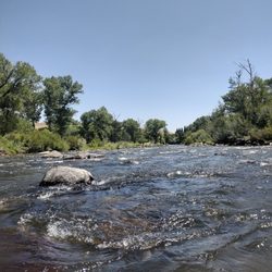
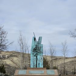
Just west of Reno, there is a flat crooked trail to a straight concrete arrow. Aiming toward the pointed ridge-top symbol, we followed the historic and popular Steamboat Ditch Trail from the Michael D. Thompson trailhead. The Steamboat Ditch was built by Chinese labor during the 1870s to carry irrigation water from the Truckee River to Reno farms and ranches. During the spring and summer months, clear water still rushes through the unlined channel. From the air, the level ditch looks like a contour line on a topographic map. We veed into drainages and curved around ridges, as we plotted our course along the ditch maintenance road. About 3.5 miles west of the trailhead, the ditch turns straight into a ridge, and flows through solid rock at the hole-in-the-wall, a 1,250-foot long tunnel. To the right of the water tunnel, we ascended the steep trail to the top of the ridgeline, turned right, and walked north along the crest for about ¼-mile to the mysterious concrete arrow. It turns out that the 57-foot long concrete pointer was poured in the early 1920s to help early pilots follow the first Transcontinental Air Mail Route. Aiming toward Reno's former Air Mail Field (now Washoe Golf Course), the yellow-painted arrow was once accompanied by a rotating gas-powered beacon atop a 50-foot tall steel tower. The beacon and tower were scrapped during World War II, and the yellow paint has long since worn away, but the arrow remains, weathered and cracked by time. Still indicating the way to Reno, this unofficial monument to the original air mail pilots endures as a straight concrete arrow at the end of a flat crooked trail.

I could have SWORN I already had a review for this trail! I thought that I wrote a review a couple of years ago to complain about the poor maintenance on the trail, and how dangerous it was, what with so many sections of trail washed out into the creek below. No? Well, that's fine, because here I am to write an update on my non-existent review to say, Hey! They fixed it! It's been a while since we hiked the Hunter Creek Trail, for the reasons I mentioned above. Poor trail conditions made it a poor choice for family hiking. But a few months back, a friend who was on the trail restoration crew told me that everything is fine now, they fixed all the sketchy sections, and that I should give it another go. And she was not exaggerating! They did a TERRIFIC job on the repairs to this trail. In fact, it's difficult to notice where the washouts even used to be! It is much safer for families now, although I would still warn people that it's probably not a great trail for younger kids unless they are experienced hikers. In fact, this warning should apply to everyone. There are lots of easy trails around Reno, and this ain't one of them. Although it is relatively short (about 6 miles round trip?), the elevation gain is at about 1200', the terrain is challenging, and the conditions are brutal for a good chunk of the hike. You will spend much of this hike exposed to the blazing sun hiking over loose, sharp rocks. If you do not have strong treads on your shoes, you will tear up your shoes and your feet. About 2/3 of the way in, the trail turns into the woods, and you spend the remainder of the hike to the falls in the shade, walking on soft forest duff. The sense of relief when you make it to this point is very real. The falls are picturesque but not very large, with enough room for a few people and some dogs to wade around in. It's set in a shady clearing, so there are lots of spots to claim for a restful picnic. If you are so inclined, the trail does continue--NOT the trail past the sign that clearly says AREA CLOSED. No, if you want to continue look for the narrow trail that climbs steeply uphill to the back left of the clearing as you enter. It is not signed, but that trail (not an easy one) will quickly lead you up over the hill and back down the other side into a lovely meadow. I haven't followed the trail past the meadow, so I'm not sure where it goes, but one thing is sure...you leave the crowds behind if you venture this far. One last thing to mention is that this trail gets CROWDED. When we went this weekend the parking lot was full, the overflow parking lot was full, and cars were parked along the side of the road for at least a quarter mile from the trailhead. If you are looking for peace and isolation, this is not the place to be. Also, there are many dogs, many off leash, so this is also not a good spot for people uncomfortable around pooches. While we were at the falls, it was basically a dog park there. Our dog had about seven others to play with. They were all well-behaved, but I thought it worth mentioning, as we passed a child on the trail who was clearly terrified of dogs. Of course, there are other trails you can take from this trailhead: The Steamboat Ditch or the ridge above Hunter Creek. The trailhead itself is great, with water (and a special dog water fountain), picnic tables, and a bathroom (currently under repairs as of this writing). It is one of Reno's best and most popular trailheads.
")
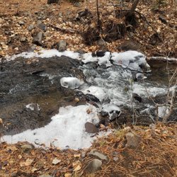
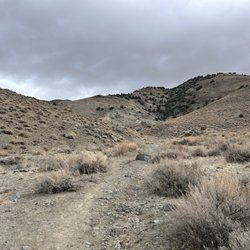
This trailhead allows access to both the Steamboat Ditch Trail, as well as Hunter Creek Falls. Note that for easier access to the Steamboat Ditch Trail, when you first turn onto Woodchuck Circle, park on the right (you'll usually see a half-dozen or so cars parked here). From here, you can head west along the trail (which runs behind the homes on Plateau, and along the irrigation ditch) - this trail will eventually take you along the Truckee, towards Mayberry Park / Patagonia outlet, and you can continue on past there to Hole in the Wall and further . . . If you go further up Woodchuck Circle, you'll end up at the actual trailhead, which provides access to Hunter Creek. From the parking lot, you head down a slight hill towards a creek. Once you get there you can either go right / north-east up a hill, which runs back into the Steamboat Ditch trail. On the other hand, if you head to the left / south-west, you'll go along Hunter Creek towards the falls. I believe this is about a 3 mile hike to the falls. Wear solid shoes or boots, as some of this can be rocky / shale covered canyon sides. Note that this is a very exposed hike, with little cover from the sun. There's a small glade at the end near the falls. If you attempt this hike in the summer, plan accordingly. In the winter, be prepared to run into snow (in fact, the first time I did this hike, I would never have found the falls as the trail was covered with snow, except I was able to follow the tracks of previous hikers). The hike is pretty incredible though, for being so accessible . . .

One of the toughest trails in Reno, but the waterfall at the end is worth the hike. This trail reminds me of a shorter version of Mt Rose, but with less shady areas to cool down to take a quick a break. It took me 1.5 hours to get to the top and 1 hour to get down and that was going at a moderate pace. It's mostly uphill so if you have a walking stick use it, but it's not necessary. Having a good pair of shoes will help your feet and legs tackle the constant uphill hike and prevent sore feet at the end. My Fitbit tracked my round trip hike at 15,680 steps, 130 floors, and 6.87 miles. The earlier you start this hike, the sooner you'll be back to your car before the summer heat kicks in. Do not bring a regular sized water bottle. Bring a bladder bag or something larger to replenish yourself with as the heat from the sun will make you very thirsty. The parking lot can get packed quickly as this is a very popular location and there are restrooms at the entrance of the trailhead for one last pit stop. When you get to the top, the cool air on your face and the cold water to soak your feet in will be a welcoming balance to the hike. I'm actually surprised and impressed to see young children and dogs on this hike because of the heat and incline, but if your family is used to this type of activity, more power to you all. Every time I've gone here, it's always the kids leading the pack which is really cool to see. Endurance and stamina is your keys to success in addition to good shoes and water. Don't skimp on the snacks - orange slices and trail mix should be your minimum. Enjoy the scenery!
 Learn more at http://www.growmilkweedplants.com/showy-milkweed-asclepias-speciosa.html")
This trail is wonderful and flat. Or maybe it is wonderful because it's flat? Either was it can be delightful. I find that there are a few access points. Sometimes I prefer to park at different places to get on the trail. That variety is nice. I have never made it to the alleged waterfall. But the stream in nice. Maybe at the top of the stream there is a fall. I dong really care. The only reason I hike the trail is to spread the milkweed seeds. The milkweed plant is awesome. In the summer the monarch butterflies land on the milkweed and lay their eggs. If your on this trail I encourage you to be aware of the plants. Some beautiful desert dwelling flowers are all around you. But you have to look close because it's pretty much a desert up there. http://www.growmilkweedplants.com/showy-milkweed-asclepias-speciosa.html

Excellent trail with an stunning waterfall reward at the end. The key is to go when the trail is not super muddy, bring water (not just a 12 oz. bottle if you are hiking), and to start early. It is an out and back trail and the round trip distance is about 6 miles with about 1800' in elevation gain. You'll encounter mainly dogs, runners, and hikers. ( No bikes allowed.) The last time up and back it took me about 2 1/2 hours.

Just got back from this hike; it was incredible! Definitely one of my favorite trails. Took about 3 hours, with a few short breaks. Quite hot in the canyon, so make sure to bring plenty of water and even a snack. The terrain varied a lot which was pretty incredible, going from desert like to forested, all the while hearing the river. Most of all, the waterfall was completely worth it. The trailhead was a little tricky to find; we were told "right at the gingerbread house then around the round about". We found the parking lot quickly, there was a very clean bathroom too! Again, wear sunscreen (ow! My shoulders!) and bring plenty of water. And dogs are allowed on leash! Enjoy this amazing escape from Reno!

")
This hike took about 2.5 hours and it led to a beautiful waterfall. Upon arriving, the grounds were clean and the path was clear. I recommend wearing hiking shoes as some parts of the trail are very rocky. Highlight of the trail was finding mountain lion prints in the snow . read more


2 years ago
My absolute favorite hike in Reno so far! My roommate and I, along with Rudi, a two year old (three in December!) German Shepherd, decided to tackle the Michael D Thompson Trailhead. This was my first time, but my roommate did this twice before and she did warn me that this was a long hike ranging to about 5-6 miles roundtrip (3 miles in, 3 miles back). She did say that the end point, which was a beautiful waterfall, would be very rewarding and worth the trek. For you hikers bringing your puppers, regardless on how conditioned your pup is, I think it's always a good idea to bring a collapsable/portable water bowl and water for them. It is a moderately long hike and the trail has very limited shade. You'd just want to make sure they're as comfortable as possible. And don't forget about yourselves, too! The hike starts off with a progressive uphill, but I honestly didn't notice it too much. If anything the heat of the sun is what really got to me. It didn't deter us from noticing the views this hike presented us. We noticed the progressive change in the environment the further we traveled. At a certain point, the rocky, craggy mountains with bushes and sagebrush began to become more abundant with greener vegetation. After that you'll reach the forest area, which provides lots of shade for a cooler rest of the hike. The trail crosses over with some very shallow river flow and we used this as an opportunity to splash down Rudi; he seemed to really enjoy it. Eventually, you'll soon start to hear the roar of the waterfall and will progressively become louder giving you an idea of just how close you are to reaching it. And once you find it, you'll get to enjoy such an amazing sight. If you wanted to, there's a small pond at the base of the waterfall if you wanted to take a quick dip..or you could sit right under the waterfall. We stayed for a bit to take some pictures and just simply appreciate the crashing falls. When we were ready, we made the trek back to the parking lot. The journey back seemed to be less strenuous, probably because it was a slight downhill. After drinking some water, Rudi fell asleep only a couple of minutes into the car ride and continued to do so the rest of the way home. read more


11 years ago
Decided to take on this trail after work in an effort to help train for the Ruby Mountain Relay. I had no idea what I was in for. The site I read about this trail mentioned this was a 2.5 mile (5 mile round trip), week turns out its actually more like 3 miles each way (6 miles round trip). The trail is fairly easy to follow. It is almost all uphill! Parts of the trail is rocky and care should be taken when going through these parts. I would say this trail is certainly challenging. Barely a quarter mile in and I was winded, guess I'm not in as good a shape as I thought. Lol. Once you do reach the end you are rewarded with a beautiful waterfall. The cool breeze coming through and the soothing sounds of the crashing water. It's great to take a moment to catch your breath and relax. Maybe even take a blanket and make a picnic of it. Overall it took me about 2 hours to do the round trip. Though I was certainly pushing myself to go as fast add I could and nearly ran down the entire way back. For the leisurely hike I would allow about 4 hours to be on the safe side. Not sure at this point if I would recommend this for kids as it is steep and a longer than most tails. But I did see several dogs on the trail and the pet's seemed perfectly happy. Enjoy the scenery and the workout :) read more


Michael D Thompson Trailhead - Reno, NV Most of the Michael D. Thompson Trailhead reviews on Yelp is actually for the Hunter Creek Trail, which eventually ends at an spectacular, but small, waterfall. The Hunter Creek Trail is an easy to moderate hike that I recommend if you're in Reno. Michael D. Thompson Trailhead basically starts off this hike and also leads to a few other trails. There is a few paved parking spots at the trailhead as well as plenty of street parking. Clean restrooms at the trailhead is also available. But I caution you. Be aware of snakes, especially the ones that rattle. We encountered 2 huge snakes on the trail. One of them was rattling and in strike mode. read more

10 years ago
12 years ago
Just west of Reno, there is a flat crooked trail to a straight concrete arrow. Aiming toward the pointed ridge-top symbol, we followed the historic and popular Steamboat Ditch Trail from the Michael D. Thompson trailhead. The Steamboat Ditch was built by Chinese labor during the 1870s to carry irrigation water from the Truckee River to Reno farms and ranches. During the spring and summer months, clear water still rushes through the unlined channel. From the air, the level ditch looks like a contour line on a topographic map. We veed into drainages and curved around ridges, as we plotted our course along the ditch maintenance road. About 3.5 miles west of the trailhead, the ditch turns straight into a ridge, and flows through solid rock at the hole-in-the-wall, a 1,250-foot long tunnel. To the right of the water tunnel, we ascended the steep trail to the top of the ridgeline, turned right, and walked north along the crest for about ¼-mile to the mysterious concrete arrow. It turns out that the 57-foot long concrete pointer was poured in the early 1920s to help early pilots follow the first Transcontinental Air Mail Route. Aiming toward Reno's former Air Mail Field (now Washoe Golf Course), the yellow-painted arrow was once accompanied by a rotating gas-powered beacon atop a 50-foot tall steel tower. The beacon and tower were scrapped during World War II, and the yellow paint has long since worn away, but the arrow remains, weathered and cracked by time. Still indicating the way to Reno, this unofficial monument to the original air mail pilots endures as a straight concrete arrow at the end of a flat crooked trail. read more


 - Hiking Near Me - Reno, Nevada")

I could have SWORN I already had a review for this trail! I thought that I wrote a review a couple of years ago to complain about the poor maintenance on the trail, and how dangerous it was, what with so many sections of trail washed out into the creek below. No? Well, that's fine, because here I am to write an update on my non-existent review to say, Hey! They fixed it! It's been a while since we hiked the Hunter Creek Trail, for the reasons I mentioned above. Poor trail conditions made it a poor choice for family hiking. But a few months back, a friend who was on the trail restoration crew told me that everything is fine now, they fixed all the sketchy sections, and that I should give it another go. And she was not exaggerating! They did a TERRIFIC job on the repairs to this trail. In fact, it's difficult to notice where the washouts even used to be! It is much safer for families now, although I would still warn people that it's probably not a great trail for younger kids unless they are experienced hikers. In fact, this warning should apply to everyone. There are lots of easy trails around Reno, and this ain't one of them. Although it is relatively short (about 6 miles round trip?), the elevation gain is at about 1200', the terrain is challenging, and the conditions are brutal for a good chunk of the hike. You will spend much of this hike exposed to the blazing sun hiking over loose, sharp rocks. If you do not have strong treads on your shoes, you will tear up your shoes and your feet. About 2/3 of the way in, the trail turns into the woods, and you spend the remainder of the hike to the falls in the shade, walking on soft forest duff. The sense of relief when you make it to this point is very real. The falls are picturesque but not very large, with enough room for a few people and some dogs to wade around in. It's set in a shady clearing, so there are lots of spots to claim for a restful picnic. If you are so inclined, the trail does continue--NOT the trail past the sign that clearly says AREA CLOSED. No, if you want to continue look for the narrow trail that climbs steeply uphill to the back left of the clearing as you enter. It is not signed, but that trail (not an easy one) will quickly lead you up over the hill and back down the other side into a lovely meadow. I haven't followed the trail past the meadow, so I'm not sure where it goes, but one thing is sure...you leave the crowds behind if you venture this far. One last thing to mention is that this trail gets CROWDED. When we went this weekend the parking lot was full, the overflow parking lot was full, and cars were parked along the side of the road for at least a quarter mile from the trailhead. If you are looking for peace and isolation, this is not the place to be. Also, there are many dogs, many off leash, so this is also not a good spot for people uncomfortable around pooches. While we were at the falls, it was basically a dog park there. Our dog had about seven others to play with. They were all well-behaved, but I thought it worth mentioning, as we passed a child on the trail who was clearly terrified of dogs. Of course, there are other trails you can take from this trailhead: The Steamboat Ditch or the ridge above Hunter Creek. The trailhead itself is great, with water (and a special dog water fountain), picnic tables, and a bathroom (currently under repairs as of this writing). It is one of Reno's best and most popular trailheads. read more

This trailhead allows access to both the Steamboat Ditch Trail, as well as Hunter Creek Falls. Note that for easier access to the Steamboat Ditch Trail, when you first turn onto Woodchuck Circle, park on the right (you'll usually see a half-dozen or so cars parked here). From here, you can head west along the trail (which runs behind the homes on Plateau, and along the irrigation ditch) - this trail will eventually take you along the Truckee, towards Mayberry Park / Patagonia outlet, and you can continue on past there to Hole in the Wall and further . . . If you go further up Woodchuck Circle, you'll end up at the actual trailhead, which provides access to Hunter Creek. From the parking lot, you head down a slight hill towards a creek. Once you get there you can either go right / north-east up a hill, which runs back into the Steamboat Ditch trail. On the other hand, if you head to the left / south-west, you'll go along Hunter Creek towards the falls. I believe this is about a 3 mile hike to the falls. Wear solid shoes or boots, as some of this can be rocky / shale covered canyon sides. Note that this is a very exposed hike, with little cover from the sun. There's a small glade at the end near the falls. If you attempt this hike in the summer, plan accordingly. In the winter, be prepared to run into snow (in fact, the first time I did this hike, I would never have found the falls as the trail was covered with snow, except I was able to follow the tracks of previous hikers). The hike is pretty incredible though, for being so accessible . . . read more
 - Hiking Near Me - Reno, Nevada")
 - Hiking Near Me - Reno, Nevada")
One of the toughest trails in Reno, but the waterfall at the end is worth the hike. This trail reminds me of a shorter version of Mt Rose, but with less shady areas to cool down to take a quick a break. It took me 1.5 hours to get to the top and 1 hour to get down and that was going at a moderate pace. It's mostly uphill so if you have a walking stick use it, but it's not necessary. Having a good pair of shoes will help your feet and legs tackle the constant uphill hike and prevent sore feet at the end. My Fitbit tracked my round trip hike at 15,680 steps, 130 floors, and 6.87 miles. The earlier you start this hike, the sooner you'll be back to your car before the summer heat kicks in. Do not bring a regular sized water bottle. Bring a bladder bag or something larger to replenish yourself with as the heat from the sun will make you very thirsty. The parking lot can get packed quickly as this is a very popular location and there are restrooms at the entrance of the trailhead for one last pit stop. When you get to the top, the cool air on your face and the cold water to soak your feet in will be a welcoming balance to the hike. I'm actually surprised and impressed to see young children and dogs on this hike because of the heat and incline, but if your family is used to this type of activity, more power to you all. Every time I've gone here, it's always the kids leading the pack which is really cool to see. Endurance and stamina is your keys to success in addition to good shoes and water. Don't skimp on the snacks - orange slices and trail mix should be your minimum. Enjoy the scenery! read more


11 years ago
12 years ago
This trail is wonderful and flat. Or maybe it is wonderful because it's flat? Either was it can be delightful. I find that there are a few access points. Sometimes I prefer to park at different places to get on the trail. That variety is nice. I have never made it to the alleged waterfall. But the stream in nice. Maybe at the top of the stream there is a fall. I dong really care. The only reason I hike the trail is to spread the milkweed seeds. The milkweed plant is awesome. In the summer the monarch butterflies land on the milkweed and lay their eggs. If your on this trail I encourage you to be aware of the plants. Some beautiful desert dwelling flowers are all around you. But you have to look close because it's pretty much a desert up there. http://www.growmilkweedplants.com/showy-milkweed-asclepias-speciosa.html read more
 Learn more at http://www.growmilkweedplants.com/showy-milkweed-asclepias-speciosa.html - Hiking Near Me - Reno, Nevada")


16 years ago
Excellent trail with an stunning waterfall reward at the end. The key is to go when the trail is not super muddy, bring water (not just a 12 oz. bottle if you are hiking), and to start early. It is an out and back trail and the round trip distance is about 6 miles with about 1800' in elevation gain. You'll encounter mainly dogs, runners, and hikers. ( No bikes allowed.) The last time up and back it took me about 2 1/2 hours. read more


11 years ago
Just got back from this hike; it was incredible! Definitely one of my favorite trails. Took about 3 hours, with a few short breaks. Quite hot in the canyon, so make sure to bring plenty of water and even a snack. The terrain varied a lot which was pretty incredible, going from desert like to forested, all the while hearing the river. Most of all, the waterfall was completely worth it. The trailhead was a little tricky to find; we were told "right at the gingerbread house then around the round about". We found the parking lot quickly, there was a very clean bathroom too! Again, wear sunscreen (ow! My shoulders!) and bring plenty of water. And dogs are allowed on leash! Enjoy this amazing escape from Reno! read more

11 years ago
First time hiking and all I can say is it was great! I like this trail. The waterfall is so beautiful and totally worth the hike. I wish there were more shade but it's okay. read more


6 years ago
12 years ago
Since the weather had been so awesome I've been hitting this trail a few times a week for cardio to get out of the gym. It's conveniently located near my house which is a plus. This isn't a challenging trail but round trip to the waterfall is 6.2 miles with little shade, uneven footing and at times a very narrow trail. If you're looking for novice hiking this may not be for you. The views are great and the waterfall really is worth the hike. If I'm with a girl friend chatting the whole way it takes about 3 hours, if I'm pushing it to keep my heart rate up I get it done in about 2 hours 10 minutes. If you're going in the warmer months start early, it's direct sun 4 out of 6 miles. Enjoy! read more
 - Hiking Near Me - Reno, Nevada")
7 years ago
11 years ago
11 years ago
12 years ago
13 years ago
14 years ago
10 years ago
15 years ago
More info about Michael D Thompson Trailhead
Juniper Ridge
Plateau Rd
Reno, NV 89509
Directions
Hours
Indoor Amenities
Outdoor Amenities
Ask the Community - Michael D Thompson Trailhead
Is this not hunter creek trail?
It may be called hunter creek trail? I just named the trail based off the signage.
Review Highlights - Michael D Thompson Trailhead
You might also consider


Why does Yelp recommend reviews?
Michael D Thompson Trailhead - hiking - Updated July 2026
Best of Reno
People found Michael D Thompson Trailhead by searching for…
Beautiful Views in Reno, Nevada
Places to Take Pictures in Reno, Nevada
Hiking Trails With Waterfalls in Reno, Nevada
Walking Trails in Reno, Nevada
Off Road Trails in Reno, Nevada
Running Trails in Reno, Nevada
Things to Do Alone in Reno, Nevada
Secluded Spots in Reno, Nevada
Dog Friendly Parks in Reno, Nevada
Swimming Lakes in Reno, Nevada
Dog Friendly Things to Do in Reno, Nevada
Scenic Overlook in Reno, Nevada
Trending Searches in Reno, NV
4th Of July Fireworks near Michael D Thompson Trailhead
Boat Rental near Michael D Thompson Trailhead
Cliff Jumping near Michael D Thompson Trailhead
Day Trips near Michael D Thompson Trailhead
Dog Friendly Trails near Michael D Thompson Trailhead
Fireworks near Michael D Thompson Trailhead
Jet Ski Rental near Michael D Thompson Trailhead
Kayak Rental near Michael D Thompson Trailhead
Lakes & Ponds near Michael D Thompson Trailhead
Off Road Trails near Michael D Thompson Trailhead
Outdoor Activities near Michael D Thompson Trailhead
Parks For Picnics near Michael D Thompson Trailhead
Public Pools near Michael D Thompson Trailhead
Public Shower near Michael D Thompson Trailhead
River Swimming near Michael D Thompson Trailhead
Rock Quarry near Michael D Thompson Trailhead
Scenic Night View near Michael D Thompson Trailhead
Scenic Overlook near Michael D Thompson Trailhead
Secluded Spots near Michael D Thompson Trailhead
Soccer Store near Michael D Thompson Trailhead
Splash Pad near Michael D Thompson Trailhead
Strawberry Picking near Michael D Thompson Trailhead
Sunrise View near Michael D Thompson Trailhead
Swimming Holes near Michael D Thompson Trailhead
Swimming Lakes near Michael D Thompson Trailhead
U Pick Farms near Michael D Thompson Trailhead
Watch Sunset near Michael D Thompson Trailhead
Browse Articles
Browse Nearby
BEST of Reno, Nevada Coffee near Michael D Thompson Trailhead
BEST of Reno, Nevada Restaurants near Michael D Thompson Trailhead
BEST of Reno, Nevada Things to Do near Michael D Thompson Trailhead
BEST of Reno, Nevada Parks near Michael D Thompson Trailhead
BEST of Reno, Nevada Breakfast near Michael D Thompson Trailhead
BEST of Reno, Nevada Playgrounds near Michael D Thompson Trailhead
BEST of Reno, Nevada Campgrounds near Michael D Thompson Trailhead
BEST of Reno, Nevada Hot Springs near Michael D Thompson Trailhead
BEST of Reno, Nevada Motel near Michael D Thompson Trailhead
Browse Brands
Related Searches in Reno, NV
Affordable Kayak Rental Services in Reno, Nevada
Best Fishing Locations and Guides in Reno, Nevada
Best Places for Horseback Riding in Reno, Nevada
Best Sledding Spots and Fun in Reno, Nevada
Check Out Off Road Trails in Reno, Nevada
Discover Dog Friendly Trails to Explore in Reno, Nevada
Discover Scenic Bike Paths in Reno, Nevada
Discover Scenic Mountain Bike Trails Near Reno, Nevada
Discover Scenic Waterfall Spots in Reno, Nevada
Discover a Hiking Trail in Reno, Nevada
Discover the Best Night Hike Trails in Reno, Nevada
Dog-Friendly Hikes With Dogs in Reno, Nevada
Enjoy Camping Adventures Around Reno, Nevada
Enjoy Exciting Mountain Biking Adventures in Reno, Nevada
Enjoy Kayaking Adventures in Reno, Nevada
Enjoy Tent Camping Spots Around Reno, Nevada
Enjoy a Beautiful Waterfall Hike in Reno, Nevada
Enjoy the Best Picnic Spots and Ideas in Reno, Nevada
Enjoy the Best Tubing Experiences in Reno, Nevada
Enjoy the Best Walking Path in Reno, Nevada
Enjoy the Best Walking Trails in Reno, Nevada
Exciting Cliff Jumping Spots in Reno, Nevada
Experience Thrilling White Water Rafting in Reno, Nevada
Explore Beautiful Parks and Green Spaces in Reno, Nevada
Explore Easy Hikes Perfect for All in Reno, Nevada
Explore Fun Activities to Do in Reno, Nevada
Explore Popular Campgrounds Near Reno, Nevada
Explore the Best Beach Spots in Reno, Nevada
Explore the Best Boating Spots in Reno, Nevada
Explore the Best Swimming Holes Around Reno, Nevada
Explore the Best Trail Options in Reno, Nevada
Family Friendly Hiking With Kids in Reno, Nevada
Find Beautiful Views in Reno, Nevada
Find Popular Ziplining Spots Around Reno, Nevada
Find the Best Parks for Picnics in Reno, Nevada
Find the Best Scenic View Locations in Reno, Nevada
Great Places to Walk in Reno, Nevada
Hiking Trails With Waterfalls in Reno, Nevada
Off Leash Dog Hiking Trails in Reno, Nevada
Plan a Scenic Drive Route Near Reno, Nevada
Popular Outdoor Activities to Try in Reno, Nevada
Popular Picnic Spots to Visit in Reno, Nevada
Safe River Swimming Areas in Reno, Nevada
Safe and Fun Parks for Kids in Reno, Nevada
Top Running Trails to Explore in Reno, Nevada
Top Swimming Lakes to Enjoy in Reno, Nevada
Top Swimming Spots and Pools in Reno, Nevada
Top Things to Do With Kids in Reno, Nevada
People who viewed Michael D Thompson Trailhead also viewed
Hunter Creek Waterfall Trail
74 reviews
Downtown
Ophir Creek Trail
4 reviews
Verdi East Trail
4 reviews
Halo Trail
1 review
Huffaker Park and Mountain Trail
45 reviews
South Reno
Erica Greif Memorial Bike Trail
3 reviews
South Reno
Galena Falls Trail
3 reviews
Rattlesnake Mountain
2 reviews
Galena Creek Regional Park
44 reviews
Mayberry Park
57 reviews
Northwest Reno