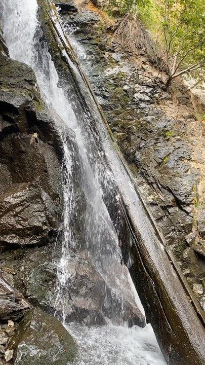
Hunter Creek Waterfall Trail Photos


You might also consider
More like Hunter Creek Waterfall Trail
Recommended Reviews - Hunter Creek Waterfall Trail
Start your review...

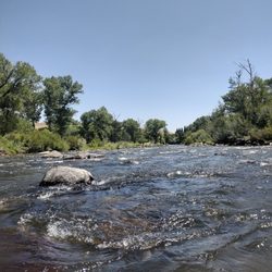
Reviews With Photos


One of my favorite hikes in Reno! The location of the trailhead makes it so easy to get to. Skip out if work and within 10 minutes I'm on the trail of one of the best hikes around. The hike starts in the sun and goes until you hit the tree line. Once you're in the tree line dumps you out at the amazing waterfall. If you're looking for the best time to go it's before July as the waterfall will be flowing well. 10/10 hike you won't find anything better in the area!

Definitely come prepared it's a bit of a hike but worth it. The waterfall at the end had a nice area to have a picnic too! It was muddy and snowy and slippery so bring hiking shoes! It was also hot towards the beginning and cold towards the end. Overall it was a beautiful hike, we saw dogs and young kids but they had their hiking gear. I am not much of a hiker so it was a little hard for me but I would do this hike again better prepared.

Did this hike with my family last weekend. It's a great trail and about 6 miles round trip. There's a waterfall at the end and this year it was so full!!! It was beautiful. Once you hit the waterfall if you head back down the trail about 30 ft there's a little path closer to the river where there are some fallen trees that you can use to cross to the other side and you get a much better view of the waterfall! Definitely worth it. It used to be easy to cross the river but since we have gotten a surplus of snow and rain this season the river is wider and roaring! The branches are wet and slippery so be careful, no one likes a soggy shoe;) The best thing you can do is start this trail when the sun comes up bc it will get busy. And bring sunblock bc most of the trail has zero shade up until the last quarter mile nearing the falls.

This is not for the faint of heart! I started my birthday week with a bang. Me and a couple of friends took this trail to a waterfall. We read that it was a three mile hike that was moderately difficult. This is a 6 mile hike, 3 miles in and 3 miles out, and it is semi-advanced. If you are an avid hiker this might be easy for you. But for me, there was some challenges. Now don't let this post scare you from trying this trail, just come prepared with water and snacks. Take breaks when you need to and you will be fine. This trail is very popular. As we were walking we saw multiple people coming and going. It's very narrow in some areas so you have to wait your turn to pass people. This trail is so beautiful and worth it to make it to the waterfall. The views were breathtaking along the way. I would recommend you do this trail in the summer. We went in the latter half of April and there was still snow the farther we walked. The snow on the ground makes hiking a lot more difficult. I'm so pleased that we were able to achieve this hike and take it off my bucket list.

Out of the places I've ever hiked in CA and in NV, this is hands down my favorite hiking place. Unlike most people who just love the act of hiking, I'll only enjoy it if it comes with a reward such as a waterfall at the end or breathtaking wilderness that's not covered in dead weeds. Length: 6.4 miles Difficulty: Moderate Elevation: 1,240 ft This was my second time hiking Hunter Creek Falls. Last year, in October, my bf and I didn't finish our hike because it was getting too late to figure out the location of the waterfall. This time, we were able to find it because of previous track marks in the snow by other hikers; all we needed to do was just follow the tracks that led directly to the waterfall. During late Oct-Nov, the temp drops to 40 something degrees and even lower if you get into the lower parts of the mountain. I thank my lucky stars that my bf brought a flashlight. Because of daylight savings and us taking way too long enjoying the waterfall, we were forced to hike in the dark on a friggin' mountain no less. We hiked in the dark with a flashlight for about 45 minutes. The music coming from the flashlight prevented me from freaking the heck out. Hiking sticks are a must if you are clumsy. We hiked in snow, so the hiking sticks prevented me from slipping. Also, we had to cross through a creek and the hiking sticks helped keep my balance. I've never seen snow before or a raging waterfall, so this was one of my memorable birthdays I've ever had. I would leave the kids at home since the trails on the side of the mountain are quite narrow. I wouldn't want my rambunctious kid to accidentally fall off the cliff.

An adventure of a lifetime... We thought this hike would be an hour each way so two hours round trip for us. Boy, were we wrong. It took us a total of five hours to do this hike for the first time but it was a journey that was truly worth it. We went through heat and dessert terrain to cold on ice and snow to get the beauty at the end, which is the amazing waterfall. I felt taken to a magical place. I can't believe all of this was just here in Reno. It was beautiful scenery. I do have to admit that I was scared and nervous at multiple points due to some of the paths being very narrow and a cliff with no protection if you fall being on one side of you. I haven't had a lot of experience with feeling like if I take a wrong step, I'd tumble to my death, so it was definitely a mental battle for me to overcome. I'm glad I had my partner with me to reassure me and help encourage me through it. It's a long journey so it might be nice to do with someone else, but since the paths are narrow, you're not necessarily going to be walking side by side the whole time. The way back was a lot quicker for us than the way there, likely because it was downhill and we were more comfortable and familiar with what we were doing. At the end of it, I felt very accomplished. It's worth the trek. Highly recommend!

Popular hiking trail located in southwest Reno, with the trailhead tucked away in an affluent neighborhood. The trailhead has a parking lot with about 20 spots and more street parking close by. The hike to the falls is roughly three miles, narrow, exposed, with over a 1000 ft elevation gain. It was moderately strenuous for myself, being in average physical shape. I saw some small kids on the trail, but I would probably be nervous to bring them as 2/3rds of the hike is on a narrow path butted up against steep slope. No matter, once you get to the last third, you get into the tree line and get some shade and different views. The creek is closer and can be heard and finally you reach a nice waterfall. There is a bench and some large fallen logs to sit on and take in the view and rest up before either heading back down or continuing to a lake (I don't know for sure, but that's what the trailhead sign said!) The reason for 4 vs 5 stars is because it gets quite popular so the trail and falls get crowded and you have to keep stopping on the narrow trail to let people by. I'd be satisfied to do this trail no more than once a year, it kicked my butt!

This is a great, moderately strenuous trail that's good for trail running, hiking, and sightseeing. I did this hike yesterday (early May) and I think the timing was perfect. The flowers were in bloom, the creek was running, and the waterfall at the end was full. Consider your abilities carefully when you do this hike- the trail is narrow in many places, there is some very minor climbing over loose rock, and it is steep in some parts, which can make passing opposite traffic a little tricky. There is no shade for the first 2/3 of the trail, so bring plenty of water. I brought my dog and she had a great time, but I'm not sure that I would do that during the middle of the summer because of how exposed it is. There were kids on the trail. Overall, I think this trail should be relatively moderate for a person in relatively good shape. My favorite part about this trail is that even though it's very close to the city, you quickly leave it behind and feel like you're in a remote area. You pass through several types of landscapes- rocky canyons, scrubby meadows, pine forest, and the waterfall. I highly recommend this trail!

This is one of Reno's hidden gems. This is a popular and usually crowded trail about a 20 minute drive from downtown Reno. We choose to hit the trail on a busy Saturday but it was definitely doable following trail etiquette, moving aside to let those that move a fast pace to pass. The trail starts out at an easy grade but soon rises at a steady elevation with many sections covered in good size rocks. The trail is about 6 miles in and out but more than half is in direct Sun, so sunscreen and hydration is a must. This trail is considered a moderate level hike and we felt that hiking poles were a benefit. Some hikers have reported rattlesnakes so use caution, we were fortunate enough to not run into any, more than likely because of the foot traffic on the trail. Half way in the trail rises before descending into the forest, this is where the effort pays off as you reach the falls. The falls are about 30 feet high and beautiful, beware some logs had to be crossed to reach it. If you love the outdoors and want to take in the wildflowers and beauty of the wilderness without a lengthy and arduous hike this is for you!


What do you do to keep from going crazy during lockdown? Hike! Thanks to Dennis L., we hiked to the falls today! The hike was a little tougher than I expected, but was still very enjoyable. The first two thirds of the hike is uphill with full sun exposure. The trail is well made but a little tight when you are trying to maintain social distancing. There was a lot of traffic as everyone seems to need an outdoor break. The last third of the hike is shaded by pines and you hear the wonderful sounds of creeks flowing ice cold from snowmelt. Then, you find the falls! Very nice! Of course, there was a bunch of people there, clustered together chatting and enjoying the view. We tried to get some pics while avoiding contact with others . The creek is flowing well. We found a spot to relax and enjoy a snack before heading back down the trail. This is a great hike for most folks. We saw all ages of people hiking and lots of dogs! Be sure to start early, bring lots of water and snacks, and pick up after your dog.

This hike is great. It is my go-to hike for visitors and friends who would like to hike about 6 miles total. The trail starts at the Michael D. Thompson trailhead, which is named after a Reno local. There is parking for at least 20 cars, and one finds the trailhead by following Woodchuck Circle until the road ends. There are toilets, a portapot (for when the toilets are locked), and a drinking fountain at the parking lot. The trailhead starts at about 5,100 ft elevation and the waterfall at the end is at about 6,200 ft. Uphill all the way there and downhill all the way back. Most of the trail is single track, and at all times one should watch one's footing. The first half of the trail is in the sun, and the second half is in the shade in the forest. It took me about 50 minutes to run and walk the uphill first half of the trail, and about 30 minutes to run back. It's much easier coming back, since it's all downhill! This trail is well-populated by humans and their dogs. It can be very muddy in the spring in the forest part of the trail because of melting snow. The views are beautiful. Sometimes you have to cross a swift little stream at the beginning of the hike. I can usually make it across the stepping stones, but the water was very high this morning, so I took off my shoes and walked barefoot across the water. Very refreshing! Sometimes in the forest part, you have to walk across a log to make it across the creek. This time I approached the waterfall from the right-hand side rather than the left, so I did not have to cross the log.

My friend and I hiked this trail just recently. It was such a beautiful day couldn't wait to get out there. We got to the trail around 9am. It was a little cool at first but once we warmed up on the trail we started taking layers off. You're pretty much going up hill all the way. It got a rocky part of the way but not to bad. We would stop in the shade for a minute to cool off. Once you get to the trees you haven't much farther to go. The falls weren't as big as I thought it would be but still pretty. I mainly went for the exercise. It's a pretty good hike and I'll definitely go again. read more


1 month ago
If you hike in Reno, you already know... Hunter Creek is a staple. Dry, exposed climb at the start, then it opens up into a cooler canyon with a waterfall waiting at the end. Always worth it. read more


8 months ago
I'm not from the area so didn't have any idea what we were headed for. The first part of the hike is pretty barren but once you're a quarter of the way in, it's beautiful. read more


1 year ago
One of my favorite hikes in Reno! The location of the trailhead makes it so easy to get to. Skip out if work and within 10 minutes I'm on the trail of one of the best hikes around. The hike starts in the sun and goes until you hit the tree line. Once you're in the tree line dumps you out at the amazing waterfall. If you're looking for the best time to go it's before July as the waterfall will be flowing well. 10/10 hike you won't find anything better in the area! read more


1 year ago
Definitely come prepared it's a bit of a hike but worth it. The waterfall at the end had a nice area to have a picnic too! It was muddy and snowy and slippery so bring hiking shoes! It was also hot towards the beginning and cold towards the end. Overall it was a beautiful hike, we saw dogs and young kids but they had their hiking gear. I am not much of a hiker so it was a little hard for me but I would do this hike again better prepared. read more


Did this hike with my family last weekend. It's a great trail and about 6 miles round trip. There's a waterfall at the end and this year it was so full!!! It was beautiful. Once you hit the waterfall if you head back down the trail about 30 ft there's a little path closer to the river where there are some fallen trees that you can use to cross to the other side and you get a much better view of the waterfall! Definitely worth it. It used to be easy to cross the river but since we have gotten a surplus of snow and rain this season the river is wider and roaring! The branches are wet and slippery so be careful, no one likes a soggy shoe;) The best thing you can do is start this trail when the sun comes up bc it will get busy. And bring sunblock bc most of the trail has zero shade up until the last quarter mile nearing the falls. read more

This is not for the faint of heart! I started my birthday week with a bang. Me and a couple of friends took this trail to a waterfall. We read that it was a three mile hike that was moderately difficult. This is a 6 mile hike, 3 miles in and 3 miles out, and it is semi-advanced. If you are an avid hiker this might be easy for you. But for me, there was some challenges. Now don't let this post scare you from trying this trail, just come prepared with water and snacks. Take breaks when you need to and you will be fine. This trail is very popular. As we were walking we saw multiple people coming and going. It's very narrow in some areas so you have to wait your turn to pass people. This trail is so beautiful and worth it to make it to the waterfall. The views were breathtaking along the way. I would recommend you do this trail in the summer. We went in the latter half of April and there was still snow the farther we walked. The snow on the ground makes hiking a lot more difficult. I'm so pleased that we were able to achieve this hike and take it off my bucket list. read more


Out of the places I've ever hiked in CA and in NV, this is hands down my favorite hiking place. Unlike most people who just love the act of hiking, I'll only enjoy it if it comes with a reward such as a waterfall at the end or breathtaking wilderness that's not covered in dead weeds. Length: 6.4 miles Difficulty: Moderate Elevation: 1,240 ft This was my second time hiking Hunter Creek Falls. Last year, in October, my bf and I didn't finish our hike because it was getting too late to figure out the location of the waterfall. This time, we were able to find it because of previous track marks in the snow by other hikers; all we needed to do was just follow the tracks that led directly to the waterfall. During late Oct-Nov, the temp drops to 40 something degrees and even lower if you get into the lower parts of the mountain. I thank my lucky stars that my bf brought a flashlight. Because of daylight savings and us taking way too long enjoying the waterfall, we were forced to hike in the dark on a friggin' mountain no less. We hiked in the dark with a flashlight for about 45 minutes. The music coming from the flashlight prevented me from freaking the heck out. Hiking sticks are a must if you are clumsy. We hiked in snow, so the hiking sticks prevented me from slipping. Also, we had to cross through a creek and the hiking sticks helped keep my balance. I've never seen snow before or a raging waterfall, so this was one of my memorable birthdays I've ever had. I would leave the kids at home since the trails on the side of the mountain are quite narrow. I wouldn't want my rambunctious kid to accidentally fall off the cliff. read more


5 years ago
An adventure of a lifetime... We thought this hike would be an hour each way so two hours round trip for us. Boy, were we wrong. It took us a total of five hours to do this hike for the first time but it was a journey that was truly worth it. We went through heat and dessert terrain to cold on ice and snow to get the beauty at the end, which is the amazing waterfall. I felt taken to a magical place. I can't believe all of this was just here in Reno. It was beautiful scenery. I do have to admit that I was scared and nervous at multiple points due to some of the paths being very narrow and a cliff with no protection if you fall being on one side of you. I haven't had a lot of experience with feeling like if I take a wrong step, I'd tumble to my death, so it was definitely a mental battle for me to overcome. I'm glad I had my partner with me to reassure me and help encourage me through it. It's a long journey so it might be nice to do with someone else, but since the paths are narrow, you're not necessarily going to be walking side by side the whole time. The way back was a lot quicker for us than the way there, likely because it was downhill and we were more comfortable and familiar with what we were doing. At the end of it, I felt very accomplished. It's worth the trek. Highly recommend! read more

Popular hiking trail located in southwest Reno, with the trailhead tucked away in an affluent neighborhood. The trailhead has a parking lot with about 20 spots and more street parking close by. The hike to the falls is roughly three miles, narrow, exposed, with over a 1000 ft elevation gain. It was moderately strenuous for myself, being in average physical shape. I saw some small kids on the trail, but I would probably be nervous to bring them as 2/3rds of the hike is on a narrow path butted up against steep slope. No matter, once you get to the last third, you get into the tree line and get some shade and different views. The creek is closer and can be heard and finally you reach a nice waterfall. There is a bench and some large fallen logs to sit on and take in the view and rest up before either heading back down or continuing to a lake (I don't know for sure, but that's what the trailhead sign said!) The reason for 4 vs 5 stars is because it gets quite popular so the trail and falls get crowded and you have to keep stopping on the narrow trail to let people by. I'd be satisfied to do this trail no more than once a year, it kicked my butt! read more


 - Hiking Near Me")
4 years ago
This is a great, moderately strenuous trail that's good for trail running, hiking, and sightseeing. I did this hike yesterday (early May) and I think the timing was perfect. The flowers were in bloom, the creek was running, and the waterfall at the end was full. Consider your abilities carefully when you do this hike- the trail is narrow in many places, there is some very minor climbing over loose rock, and it is steep in some parts, which can make passing opposite traffic a little tricky. There is no shade for the first 2/3 of the trail, so bring plenty of water. I brought my dog and she had a great time, but I'm not sure that I would do that during the middle of the summer because of how exposed it is. There were kids on the trail. Overall, I think this trail should be relatively moderate for a person in relatively good shape. My favorite part about this trail is that even though it's very close to the city, you quickly leave it behind and feel like you're in a remote area. You pass through several types of landscapes- rocky canyons, scrubby meadows, pine forest, and the waterfall. I highly recommend this trail! read more


This is one of Reno's hidden gems. This is a popular and usually crowded trail about a 20 minute drive from downtown Reno. We choose to hit the trail on a busy Saturday but it was definitely doable following trail etiquette, moving aside to let those that move a fast pace to pass. The trail starts out at an easy grade but soon rises at a steady elevation with many sections covered in good size rocks. The trail is about 6 miles in and out but more than half is in direct Sun, so sunscreen and hydration is a must. This trail is considered a moderate level hike and we felt that hiking poles were a benefit. Some hikers have reported rattlesnakes so use caution, we were fortunate enough to not run into any, more than likely because of the foot traffic on the trail. Half way in the trail rises before descending into the forest, this is where the effort pays off as you reach the falls. The falls are about 30 feet high and beautiful, beware some logs had to be crossed to reach it. If you love the outdoors and want to take in the wildflowers and beauty of the wilderness without a lengthy and arduous hike this is for you! read more


Such a short drive from downtown Reno for this beautiful hike! Beginning and end of the hike have very little shade, but then you hit the area with great tree cover!! The waterfall is stunning - total hike is about 6 miles and took about 2 hours plus time spent at the waterfall. read more


What do you do to keep from going crazy during lockdown? Hike! Thanks to Dennis L., we hiked to the falls today! The hike was a little tougher than I expected, but was still very enjoyable. The first two thirds of the hike is uphill with full sun exposure. The trail is well made but a little tight when you are trying to maintain social distancing. There was a lot of traffic as everyone seems to need an outdoor break. The last third of the hike is shaded by pines and you hear the wonderful sounds of creeks flowing ice cold from snowmelt. Then, you find the falls! Very nice! Of course, there was a bunch of people there, clustered together chatting and enjoying the view. We tried to get some pics while avoiding contact with others . The creek is flowing well. We found a spot to relax and enjoy a snack before heading back down the trail. This is a great hike for most folks. We saw all ages of people hiking and lots of dogs! Be sure to start early, bring lots of water and snacks, and pick up after your dog. read more


8 years ago
This hike is great. It is my go-to hike for visitors and friends who would like to hike about 6 miles total. The trail starts at the Michael D. Thompson trailhead, which is named after a Reno local. There is parking for at least 20 cars, and one finds the trailhead by following Woodchuck Circle until the road ends. There are toilets, a portapot (for when the toilets are locked), and a drinking fountain at the parking lot. The trailhead starts at about 5,100 ft elevation and the waterfall at the end is at about 6,200 ft. Uphill all the way there and downhill all the way back. Most of the trail is single track, and at all times one should watch one's footing. The first half of the trail is in the sun, and the second half is in the shade in the forest. It took me about 50 minutes to run and walk the uphill first half of the trail, and about 30 minutes to run back. It's much easier coming back, since it's all downhill! This trail is well-populated by humans and their dogs. It can be very muddy in the spring in the forest part of the trail because of melting snow. The views are beautiful. Sometimes you have to cross a swift little stream at the beginning of the hike. I can usually make it across the stepping stones, but the water was very high this morning, so I took off my shoes and walked barefoot across the water. Very refreshing! Sometimes in the forest part, you have to walk across a log to make it across the creek. This time I approached the waterfall from the right-hand side rather than the left, so I did not have to cross the log. read more


A dirt packed trail that begins with a good parking lot and restrooms/portable potty. Walk down and ya get baptized by the walk across the refreshing river. About an hour in to a decent waterfall. On the way, its slightly treacherous in that trail gets narrow and a miss-step or slip will send you down a steep hill! Some parts are so narrow that you grab the side mountain while people pass you. Save 2 hours in and out. Bring water and good shoes. It does get hot, so bring a good hat. A good challenging hike read more


8 years ago
Looking for a hike to a waterfall but don't wanna drive out of the city? Then this hike is for you. I've done this hike seveal times in the last 2 years and it's really enjoyable. It takes me about 1.5 hours to get to the falls and about 40 mins to get back (jogging part of the way). *I'm a fast-paces hiker so it is completely common to get to the falls in 2+ hours. I would recommend bringing plenty of water on warm/hot days because at least 60% of the trail has full sun exposure. I also recommend bringing a small lunch or snacks to enjoy at the falls, as there is plenty of large logs to sit and enjoy the view. What I've noticed over the last year (and my reason for the 4 stars) is that the trail has become somewhat congested...but still very enjoyable for most people. I simply prefer quiet trails. Enjoy! read more


5 years ago
I'm not active at all so this was definitely hard for me. It's a little dangerous too because the path is rocky and sometimes only rocks haha. The scenery is beautiful. It gets hot on the way up but once you're up there its really cold. I went on Nov. 27th, so I went on a cold day. There's isnt too much shade until near the end. Id recommend this hike for someone who likes hikes and is an active person. It can be difficult for kids too. Just gotta be careful. I slipped and almost rolled down the hill. It was my fault since I only wore regular running shoes. You definitely should wear hiking shoes here. read more


6 years ago
A lovely place for a hike no matter the season! It's not terribly difficult, but we did see a rattlesnake on the trail so just be careful of that. The waterfall at the end was peaceful, and there were plenty of other hikers there along the way. One of my favorite hiking spots in Reno! read more


I did the Hunter Creek Trail up to the waterfall and it was an amazing hike, right in NW Reno, the waterfall is raging! If you have never been, I highly recommend it! There are bathrooms and a water fountain at the trail head. You will need to cross the creek in the beginning of the hike, and due to the current high water level, just walk alongside the creek until you get to a metal grate bridge for a safe crossing. The hike is moderate, 5.7 miles round trip with a 1,200 ft elevation gain. Wear hiking shoes with great ankle support! It was a breezy 60 degrees, perfect for hiking. Shortly after I crossed the creek, I saw a cave on a hillside and decided to go check it out. The climb was rough but the views well worth it! Once you are in the forest, you are home free and the waterfall is close by, keep going! You can pat yourself on the back for a good climb. You do have to cross a log for the best view. The reward was well worth it! read more


8 years ago
The Hunter Creek Waterfall Trail is a gorgeous hiking venue! It comes in as light to moderate on Janey's HDD (Hiking Degree of Difficulty) scale, and it's just under six miles for the round trip. Tip: Topographically, this hike is generally uphill on the outward leg of the trail, and downhill on the return. As for creek crossings, there are three of them along the trail (two that consist of large logs and one that has a metal bridge), but all are easy to circumnavigate. On my most recent visit, I didn't see any wildlife, which I found surprising. There's free public parking, clean restrooms, and a drinking fountain at the beginning of the trail. That said, it's a good idea to carry water with you along the hike, as there's no drinking water along the trail. While dogs are welcome here, there are some fairly rocky stretches that might be hard on Fidos paws, so dog owners should take precautions. read more


Living in Reno for so many years and I didn't realize this was here until I was about to move basically. For me, I feel this was a moderate hike, esp for around 6 miles round trip (~3 hrs). There were some parts where I felt like it was steep coming up and back. Walking sticks definitely helped me on this hike, but I know you can do it without them too. :) Parking - there is a parking lot and also dirt parking before you hit the parking lot just in case it gets full. Amenities - there is a bathroom next to the parking lot with a sink. Like the sign says, please don't wash your muddy shoes or paws in there :) There is also a sink for water refills by the parking lot too. There are little bridges over the water, but also trails around the water too if you're afraid to fall in. Waterproof shoes definitely helped and hiking shoes were a plus for me because of the grip they offered on the sand. I have seen people do it in nikes and such, it's honestly up to you what you want to wear. It was a good opportunity to break in my hiking shoes though! All in all, be mindful when you go. I went at noon, doable but hard because it's straight sun and basically no shade for the first hour+. Sunscreen, lots of water (I used 2L round trip during 90+ weather), a hat, snacks if you expect to picnic at the waterfall or in case you get hungry, extra socks in case you fall into the water and a camera for those photos :P read more

This hike kicked my butt but it's because I did it completely wrong (sorry, lame Californian who didn't listen to all my Reno local friends). I went on a Thursday morning around 10am (NOT AN IDEAL TIME TO GO) in August (so hot) - be aware that five sixths of this height is in the sun with no shade. The whole hike takes about 3-4 hours if you're going at a moderate pace and taking a few breaks along the way, and spending maybe 30 mins at the waterfall to enjoy it. It's 3 miles in, 3 miles back out. The actual trail head is a little tricky to find if you're not familiar - the hike actually begins at the Michael D Thompson trailhead (yelp that location to find the trailhead). If you're using apple maps and you type in the hunter creek waterfall trail, it won't take you to the right location (at least it didn't on my phone, it kept leading us into gated residential areas on a hill). A kind local biker told us to not turn left or right but to keep driving past the roundabout until we saw the trailhead / parking lot on our right. The trailhead has bathrooms, parking spaces for maybe 20 cars, good water fountains, and a few benches you can chill at. Something that my friend and I did on accident was that we took the thin trail on the left (instead of the big fat trail leading to the river), and it wasn't until we got 30 mins in on that side of the hill/mountain that we looked across the river and saw people hiking on the ACTUAL trail (no wonder it was so hard and the trail was barely existing and we had to hold on to plants and almost slipped on rocks) - don't make our mistake. If you do start out on the thin trail on the left when you're facing away from the parking lot, you reach this point where you cross the river on a metal bridge (that's how you know you're going the right direction) - once you cross the river, the rest of the trail is very obvious (basically, if you feel like the trail isn't super clear, you might not be hiking on the right side of the river. - If that happens, backtrack until you find the metal bridge. The actual real trail is very easy to follow even though there's no signage. You'll hear the river most of the way too. BRING LOTS OF WATER! - I only brought a 1000mL camelback and it wasn't enough, I finished it before I reached the waterfall. Also bring sunscreen, because so much of the hike is straight up in the sun with minimal shade (you only reach the forest maybe when you're 15-20 mins out from the waterfall), your shoulders will get burned. Wear a hat/ sunglasses too, especially if you're doing this in the summer. Bring good shoes, it's possible to do it in Nike frees but there are definitely some parts where the trail is thin and the rocks get slippery - and when you get to the waterfall the rocks are definitely slippery if you try to get close to it - I ended up taking my shoes off. There's a few rock-slide type setups you'll have to walk across, so watch out if you have weak ankles. Just when you feel like the hike is getting too hard and hot (if you're like me and didn't think through things properly and didn't go until the middle of the day) - just push through like 15 more minutes and you'll reach the shade/ forest area. We encountered one snake on the trail (I almost didn't see it because it was so camouflaged). Theoretically, this hike is not THAT challenging in its elevation change and incline. HOWEVER - it's difficult if you aren't ready for the elements (if you're from lower elevation and you're visiting Reno from out of town, say like, Sacramento, you'll definitely feel it on this hike. I got a little lightheaded too because on this day there was a lot of smoke from the fires settling in Reno and I wasn't getting enough oxygen). If you come prepared with water though, you should be fine (my friend and I literally chugged water for 4 mins straight when we got back to the trailhead...) My suggestion is to do this trail as early as you can (or make it a night hike) - the sun is no joke. The waterfall is small compared to waterfalls in the PNW but it's pretty fun, it's raging at this time of year and we sat on the rocks and dipped our feet in the cold water and it was really great. Before you reach the waterfall you might have to cross some logs to get to the other side, but it's pretty doable. Overall it's a great trail, just come very prepared. A really good go-to for if your friends are visiting Reno! read more


When trying to decide where to hike, this is almost always my go to trail. It is a pretty hike with many different views, it is challenging enough for a work-out but easy enough for almost anyone to complete. It is approximately 6 miles round trip and at the end of the trail, there is a beautiful water fall. If you're from Reno this is a site that you don't get to see every day. I like starting in the morning then having a picnic at the waterfall before making a leisurely return to the trail head. The trail is pretty rocky and has some steep parts. I've also hiked this in the winter and as long as it is a relatively warm day and the snow has had a few days to melt since the last storm, this is a safe trail and the frozen waterfall at the end is beautiful! read more

11 years ago
Decided to take on this trail after work in an effort to help train for the Ruby Mountain Relay. I had no idea what I was in for. The site I read about this trail mentioned this was a 2.5 mile (5 mile round trip), week turns out its actually more like 3 miles each way (6 miles round trip). The trail is fairly easy to follow. It is almost all uphill! Parts of the trail is rocky and care should be taken when going through these parts. I would say this trail is certainly challenging. Barely a quarter mile in and I was winded, guess I'm not in as good a shape as I thought. Lol. Once you do reach the end you are rewarded with a beautiful waterfall. The cool breeze coming through and the soothing sounds of the crashing water. It's great to take a moment to catch your breath and relax. Maybe even take a blanket and make a picnic of it. Overall it took me about 2 hours to do the round trip. Though I was certainly pushing myself to go as fast add I could and nearly ran down the entire way back. For the leisurely hike I would allow about 4 hours to be on the safe side. Not sure at this point if I would recommend this for kids as it is steep and a longer than most tails. But I did see several dogs on the trail and the perry's seemed perfectly happy. Enjoy the scenery and the workout :) read more

 - Hiking Near Me")


8 years ago
6 years ago
Great in/out hike. Took a few tries to find the "end" and the waterfall reveal (well worth it) but overall excellent rolling terrain, some rocky, with the wonderful water rushing sound almost the entire hike. Wooded near the end but exposed most of the rest. Dogs loved it especially with lots of opportunities to get wet. read more


Hunter Creek Waterfall Trail is one of the best, if not the best, hike in Reno! Driving here can be a little difficult since you have to go through a neighborhood to get to the parking lot, but this hidden gem is definitely worth it. The parking lot is ample and there are more than enough spaces if you get there early. If you get there when parking is full, there is also some dirt parking right outside the paved parking spots, so it shouldn't be a problem. The trail itself is about 6 miles round trip. The weather / winter has definitely taken its toll on the trail nowadays. To start off, the amount of water running through the creek feels like an all time high. It will definitely lower during late spring to early fall, when the weather is a lot warmer, but you will definitely have to cross some streams and will definitely get wet if you go during late fall to early spring. The first stream you would have to go through is at the beginning. Depending on how deep and fast the water is flowing, I would recommend just powering through it if you feel comfortable and safe. Otherwise, you would have to backtrack all the way to the parking lot to find an off-beaten trail (it's on the left if you're coming from the parking lot, on the right if you're coming from the trail. it's near the fire lane). That small trail leads you to the left side of the creek. Eventually, you'll reach a metal bridge that you can cross to get to the actual trail. The weather has also caused a couple of mudslides and new, small streams. The mudslides eroded parts of the trail. People either go through the mud or go above it to get across. Just be warned that your shoes will both get muddy and wet. When the weather isn't taking a toll on the trail, the trail is pretty straight-forward and easy to follow. There's compact dirt, there's rocks, and then it becomes a wooded/forest-y area that eventually gets you to the waterfall. There's not much shade until you get to the wooded area, so I would recommend bringing a hat or wearing sunscreen. Before you reach the waterfall, you have to cross the creek again. During the summer, crossing the creek shouldn't be a problem since there are logs there and the water level should be lower. But during the winter / colder parts of the season, the water level is high, partially submerging the logs. So I would definitely be careful crossing here, because one small step could injure you. Overall, I love hiking this trail. This is my "go to" trail for hiking, during the winter and the summer. Always check the weather when hiking, bring ample amounts of water, and be sure to wear good shoes! read more


Hunter Creek Waterfall Trail - Reno, NV I was not prepared for this hike or any hike in general. Rule #1: Take enough hydration with you. I didn't and I know better. I had a little less than 6 oz. of fluids with me and sipped only when I desperately needed it. Big mistake. Rule #2: Wear comfortable clothing and a good pair of sturdy shoes with traction. I wore comfortable clothing, but had the wrong pair of shoes. I wore weightlifting shoes that had zero ankle support, no traction, and very little sole support. My feet and ankles felt it during and after the hike. Bottom line...bring enough hydration and the right pair of kicks. Now for the review. The hike from the Michael D Thompson Trailhead parking lot to the actual waterfall is a little over 3 miles one way and will take about 1.5 hours at a walking pace. The trail itself is clearly defined, easy to follow, and ranked as moderate. Majority of the trail also follows the raging river, which can also be heard throughout the entire hike. This is not a difficult hike and the only challenges I see is the few times that you have to cross the river. Makeshift bridges made up of tree branches will get you across the river. Be careful when crossing the river. The river current is strong and the makeshift bridges are very slippery. The Hunter Creek Waterfall is at the end of the trail. There, you can enjoy that fact that you got to the end and snap a few photos. I'm not going to lie. The waterfall is small, but it's still a sight to seen and worth the hike. TIP #1: Most of the Yelp reviews for this hike is actually on the Michael D Thompson Trailhead Review. TIP #2: 90% of the hike is not shaded. Bring your sunscreen if you burn easily. TIP #3: Snakes on the trail. I repeat. Snakes on the trail. We encountered a rattlesnake and another huge snake on the trail. You've been warned. TIP #4: Hike is about 6 miles round trip. Elevation gain is very minimal. TIP #5: Popular hike in Reno. Dog friendly. read more


It's a moderate level very rocky incline 3 mile hike up to a waterfall. The sight is dry at first but it slowly transitions into a beautiful forest. Towards the end of the hike, to get to the waterfall, you will need to either walk through streams of water or over a giant log. Back down another 3 miles to get to vehicle. The spa like sound of water rushing is heard throughout the hike. The paths are narrow, so go early am to avoid crowds. Trail had lots of dogs, so I assume it's pet friendly. If you're looking for an address, type in Michael D Thompson Trailhead to get to exact spot with parking. Enjoy! ;) read more


This trail is fairly easy and time goes by fast because the scenery changes from dry desert, rocky roads, and then beautiful tall green trees. Listen carefully and you'll hear the creek most of your hike. There's a couple logs you'll have to cross as well. It's about 5.8 miles, dog friendly, and if you get up early enough, the hike isn't too busy. read more

9 years ago
Recommended advise: 1. Bring lots of water 2. Snacks 3. Sun cover, unless you want to get baked 4. Good hiking shoes 5. Go early, so you don't get heat stroke hiking in 90 degree afternoon temps Likes: Intermediate challenge hike-wise. About 1000 feet changes in elevation to reach the waterfall. Picturesque views. Restroom at the beginning at the parking lot. Dislikes: If you have fear of heights, some areas of the trail are next to some rocky cliffs. It's a 3 maybe 3.5 mile hike to the waterfall, which feels like 6 in hot weather. The waterfall is nice and cool. Worth the hike! read more


My sister and I took this hike based on its proximity to my dad's new house at Somerset near Boomtown. I was very happy to find that it shows up on Google Maps, so if you search for Hunter Creek Trail, the map will guide you via GPS right to the trailhead's ample parking lot. We were lucky enough to catch it with some nice weather and most of the snow had melted, which made the creek loud and powerful. The hike is an out-and-in hike...not a loop. That is, you walk out in a straight line, turn around, and come back the same way you went out. I read some conflicting reviews on this place before doing the hike, so I wanted to clarify time /mileage/ difficulty for everyone. We went all the way to the waterfall, which according to the GPS, measured 6.7 miles (roundtrip), and it took us three hours to complete. In fairness, we stopped a few times to take pictures and look around because the views were awesome. Also good to know: you will climb over 1100 feet in elevation over the course of the 3.35 mile climb. As for the difficulty, moderate is the best way to describe this. The walk itself isn't all that tough, but some stretches of terrain are pretty challenging. These stretches include crossing rock and log bridges, rock piles, and snowy and muddy terrain (see photos). The snow and mud shouldn't be too much concern later in the spring and summer months, though. The waterfall itself is a nice reward for the hike. When we saw it, it was still covered in snow, which was awesome. It's somewhere between 35-50 feet high and it is currently raging. It's actually legal to camp up at the waterfall, but they ask that you set up camp 200 feet from the falls itself. If you're in the area, this is a great one that covers lots of different terrain and some great views of the mountains, valleys, creek, and Reno's skyline. read more

 creek crossing. This is the last one before you get to the waterfall. - Hiking Near Me")


9 years ago
Been at this trail few times, and after my 3rd trips - I finally finished the hike with my son - WooHoo So happy and proud and soo tired at the same time. It took us hours to finish this trail, more on my side being too slow of course -- views were nice, mountains, trees, rocks, etc... Keep hydrated and bring more water (its a must!) We did had a great time tho' :-) So, to everyone planning to check out Hunter Creek Trail - have fun and enjoy! read more


This hike is almost 7 miles long. If you walk at a moderate pace, even with more than a few rest/water stops, you should finish this hike under 3 hours. As with any hike in the desert, it's better to start it very early (like 6AM) so it won't be so hot. There isn't a lot shade on this hike until you get to the forest area which is at about 80% (1.25 hours) of the first stretch to the waterfall. As with any hike, always have water (2 bottles a person should be adequate), dress light, have a hat, bring sunscreen, and take breaks in the shade. The trail is clean and pretty easy. Lots of people take their dogs with them. This is probably the best hike that is within a 15-minute drive from downtown Reno, even though the waterfall isn't even that amazing. read more


7 years ago
Yup still 5 stars. Clean trail. Easily identified. Went in the evening and was trying to make it back to the car before dark. I took my time walking up and it took about 90 mins. Walking back to the car took about 60 mins. There were people on this trail even around sunset. I wouldn't want to hike in the dark, especially since I brought the dog. I loved the sound of the creek along the hike. This could possibly be one of my favorite hikes in Reno. Please let me know if you recommend another trail with a great view, especially a waterfall. read more


7 years ago
10 years ago
A nice hike a little over 6 mile round trip with steady incline. You walk above a stream and receive nice views of the mountain, some wildflowers, lots of lizards, butterflies, and an active caterpillar. Hike involves crossing some streams, including one at the very end to reach the waterfall at the end. Not too challenging and nice reward at the end. Word to the wise: leave the strollers at home! read more


Page 1 of 2
More info about Hunter Creek Waterfall Trail
Reno, NV 89501
Downtown
Directions
Hours
Outdoor Amenities
Ask the Community - Hunter Creek Waterfall Trail
Review Highlights - Hunter Creek Waterfall Trail
You might also consider


Why does Yelp recommend reviews?
1 review that is not currently recommended
The reviews below are not factored into the business's overall star rating.
4 years ago
Hunter Creek Waterfall Trail - hiking - Updated May 2026
Best of Reno
People found Hunter Creek Waterfall Trail by searching for…
Beautiful Views in Reno, Nevada
Places to Take Pictures in Reno, Nevada
Natural Hot Springs in Reno, Nevada
Hiking Trails With Waterfalls in Reno, Nevada
Walking Trails in Reno, Nevada
Dog Friendly Things to Do in Reno, Nevada
Off Road Trails in Reno, Nevada
Off Leash Dog Hiking Trails in Reno, Nevada
Mountain Bike Trails in Reno, Nevada
Dirt Bike Trails in Reno, Nevada
Trending Searches in Reno, NV
Boat Rental near Hunter Creek Waterfall Trail
Botanical Gardens near Hunter Creek Waterfall Trail
Bounce House Rentals near Hunter Creek Waterfall Trail
Campgrounds near Hunter Creek Waterfall Trail
Cheap Plants near Hunter Creek Waterfall Trail
Cherry Picking near Hunter Creek Waterfall Trail
Cliff Jumping near Hunter Creek Waterfall Trail
Flower Fields near Hunter Creek Waterfall Trail
Flower Shop near Hunter Creek Waterfall Trail
Garage Sales near Hunter Creek Waterfall Trail
Garden Center near Hunter Creek Waterfall Trail
Lakes & Ponds near Hunter Creek Waterfall Trail
Nurseries & Gardening near Hunter Creek Waterfall Trail
Outdoor Activities near Hunter Creek Waterfall Trail
Outdoor Furniture Stores near Hunter Creek Waterfall Trail
Parks near Hunter Creek Waterfall Trail
Party Equipment Rentals near Hunter Creek Waterfall Trail
Pedicure near Hunter Creek Waterfall Trail
Photo Spots near Hunter Creek Waterfall Trail
Picnic Areas near Hunter Creek Waterfall Trail
Places To Take Pictures near Hunter Creek Waterfall Trail
Rock Quarry near Hunter Creek Waterfall Trail
Running Trails near Hunter Creek Waterfall Trail
Rv Rental near Hunter Creek Waterfall Trail
Scenic Drive near Hunter Creek Waterfall Trail
Sunrise View near Hunter Creek Waterfall Trail
Swimming Holes near Hunter Creek Waterfall Trail
Table And Chair Rentals near Hunter Creek Waterfall Trail
Browse Articles
Browse Nearby
BEST of Reno, Nevada Coffee near Hunter Creek Waterfall Trail
BEST of Reno, Nevada Restaurants near Hunter Creek Waterfall Trail
BEST of Reno, Nevada Things to Do near Hunter Creek Waterfall Trail
BEST of Reno, Nevada Parks near Hunter Creek Waterfall Trail
BEST of Reno, Nevada Walking Trails near Hunter Creek Waterfall Trail
BEST of Reno, Nevada Campgrounds near Hunter Creek Waterfall Trail
BEST of Reno, Nevada Breakfast near Hunter Creek Waterfall Trail
BEST of Reno, Nevada Sightseeing near Hunter Creek Waterfall Trail
BEST of Reno, Nevada Visitor Centers near Hunter Creek Waterfall Trail
Browse Brands
Related Searches in Reno, NV
Affordable Kayak Rental Services in Reno, Nevada
Best Fishing Locations and Guides in Reno, Nevada
Best Places for Horseback Riding in Reno, Nevada
Best Sledding Spots and Fun in Reno, Nevada
Check Out Off Road Trails in Reno, Nevada
Discover Dog Friendly Trails to Explore in Reno, Nevada
Discover Scenic Bike Paths in Reno, Nevada
Discover Scenic Mountain Bike Trails Near Reno, Nevada
Discover Scenic Walking Paths in Reno, Nevada
Discover Scenic Waterfall Spots in Reno, Nevada
Discover a Hiking Trail in Reno, Nevada
Discover the Best Night Hike Trails in Reno, Nevada
Dog-Friendly Hikes With Dogs in Reno, Nevada
Enjoy Camping Adventures Around Reno, Nevada
Enjoy Exciting Mountain Biking Adventures in Reno, Nevada
Enjoy Kayaking Adventures in Reno, Nevada
Enjoy Tent Camping Spots Around Reno, Nevada
Enjoy a Beautiful Waterfall Hike in Reno, Nevada
Enjoy a Scenic Walk in Reno, Nevada
Enjoy the Best Picnic Spots and Ideas in Reno, Nevada
Enjoy the Best Tubing Experiences in Reno, Nevada
Enjoy the Best Walking Trails in Reno, Nevada
Exciting Cliff Jumping Spots in Reno, Nevada
Experience Thrilling White Water Rafting in Reno, Nevada
Explore Beautiful Parks and Green Spaces in Reno, Nevada
Explore Easy Hikes Perfect for All in Reno, Nevada
Explore Fun Activities to Do in Reno, Nevada
Explore Popular Campgrounds Near Reno, Nevada
Explore the Best Beach Spots in Reno, Nevada
Explore the Best Boating Spots in Reno, Nevada
Explore the Best Swimming Holes Around Reno, Nevada
Explore the Best Trail Options in Reno, Nevada
Family Friendly Hiking With Kids in Reno, Nevada
Find Beautiful Views in Reno, Nevada
Find Popular Ziplining Spots Around Reno, Nevada
Find the Best Parks for Picnics in Reno, Nevada
Find the Best Scenic View Locations in Reno, Nevada
Hiking Trails With Waterfalls in Reno, Nevada
Off Leash Dog Hiking Trails in Reno, Nevada
Plan a Scenic Drive Route Near Reno, Nevada
Popular Outdoor Activities to Try in Reno, Nevada
Popular Picnic Spots to Visit in Reno, Nevada
Safe River Swimming Areas in Reno, Nevada
Safe and Fun Parks for Kids in Reno, Nevada
Top Running Trails to Explore in Reno, Nevada
Top Swimming Lakes to Enjoy in Reno, Nevada
Top Swimming Spots and Pools in Reno, Nevada
Top Things to Do With Kids in Reno, Nevada
People who viewed Hunter Creek Waterfall Trail also viewed
Michael D Thompson Trailhead
27 reviews
Cross Peak Hiking Trail
16 reviews
Upper Thomas Creek - Whites Creek - Dry Pond Trail
7 reviews
Lower Galena Creek Trail - Jones-Whites Loop - Church's Pond
19 reviews
Ballardini Ranch Trailhead
14 reviews
Evans Creek Trailhead
22 reviews
Tom Cooke Trail
3 reviews
Northwest Reno
Huffaker Park and Mountain Trail
45 reviews
South Reno
Mayberry Park
57 reviews
Northwest Reno
Steamboat Ditch Trail
6 reviews