Cross Peak Hiking Trail Photos


You might also consider
More like Cross Peak Hiking Trail
Recommended Reviews - Cross Peak Hiking Trail
Start your review...

Reviews With Photos

It's not the most adventurous trail in the area, but the trek is a decent challenge, the trail is easily accessible, and the payoff is incredibly scenic! The first part of the trail is paved, and borders a neighborhood, but you quickly get on the dirt as the trail winds up into the Mt. Rose Wilderness. It's tree covered along some short switchbacks until the forest ends, revealing a large rocky meadow and the peak. From there the trail winds steeply upward, at times offering numerous options for traversing your way to the top. One thing remains constant throughout this portion, loose rock and gravel. You will slip, so be extra cautious and aware, as well as prepared to adapt along the way up. The peak seems farther than it is, and the incline can appear daunting in places, but it is not as hard as it looks. It's just challenging enough to be enjoyed by all, and it's off leash dog friendly! Top: go early in the AM to catch the sunrise or the evening for the sunset! Since it's exposed, midday would be HOT!

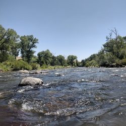
Funny how for years I walked the dog and rode my bike in the area, and never knew this trail was here. Joining a series of Yelp hikes this summer has helped me discover some great area trails. You actually start on the Steamboat Ditch Trail, and that entrance was a bit tricky to find. It's a bike / walking path in a residential neighborhood. Bitteroot Street is the only parking available. Take the paved trail south and follow it to a tunnel under the road. In a bit you exit the neighborhood and paved trail onto a small dirt trail, now your on the Cross Peak section. The paved area and a little of the dirt path are well shaded and have a comfortable temperature since you are alongside a small creek and well shaded. But once you leave that, the temperature rises. It's a beautiful gradual incline of 200 feet for maybe a mile. Then at the base of Cross Peak, you start you a pretty good ascent of 400 feet. The last half involves a little rock climbing. From Bitteroot to the top was about 30 minutes. You've made it to the top, now sit back and enjoy the spectacular view of Reno. We sat on the peak for probably 20 minutes taking in the sights and the cool evening breeze. We did a sunset hike. So in early August we left Bitteroot shortly after 6pm, and was able to watch the sun set behind the Sierras. Yet still have enough light to walk back. Take your time coming down the peak. The trail is narrow and mostly loose dirt and rocks. I would really recommend decent hiking shoes or boots. The round trip was just under a couple of hours. It is an easy hike, and the brief climb was fun. I recommend early morning or evening to do the peak since you are out in the open sun. Water and sunscreen are a must, even for this short hike. Discover the outdoors and your inner mountain goat.

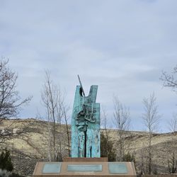
Everything about this hiking trail was beautiful and easy enough to take my kids, with the youngest being 8. Finding where to park and start the hike is the most challenging. I was only able to find it because of other Yelp reviews that gave directions. We started on Bitterroot street and got onto the steam boat ditch trail. We just took our time and enjoyed the journey. It took us two hours but if you don't stop to play and jump in every stream of water you see, it'll probably only take about an hour to the top. The hike to the top has it's rewards! The view is spectacular. There is something about sitting on top of that mountain with crosses and statues of saints that just gives you a great feeling of peace. The top gets a little slippery with the loose gravel so make sure you wear shoes that have a little bit of traction. Enjoy the journey.

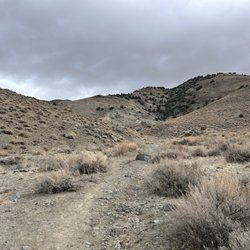
This trail is kind of hard to find if you haven't taken it before. There are many different ways to enter the trail and different ways to reach Cross Peak. Perhaps the most common way to enter the trail is to park on Bitteroot Road in Reno then take the entrance to the Steamboat Ditch Trail. This trail will eventually lead you to a dirt road at the base of some hills. From here, you can look up and you'll see Cross Peak. This is the shortest and most direct way to get to Cross Peak. My favorite route is to start somewhere along Caughlin Ranch Parkway or to start at Mayberry Landing. To the left of Yogurt Beach, there is a small walkway that leads you into Caughlin Ranch. It is flat and paved for a few miles. After walking along that until the road ends, you enter into a valley. The valley is beautiful and you can go really deep back into it. There is a river and there is some interesting foliage and wreckage to see along the path. After about 2 miles in the valley, you take a right up a pretty steep hill, walk around that hill, and you'll be on the top of Cross Peak. From there, you can take the straight path down the hill in the dirt. (This is my favorite route but I wouldn't recommend it unless you were with someone who knew the valley - it's easy to get lost and to keep going deeper into the mountains). Cross Peak is a great hike because there are some steep hills and a beautiful view at the end!

Great trail! It was pretty, I started near the tennis courts and got up to the actual trail after awhile. I hiked it with my pup and she loved it because of the creek that runs along pretty much the entire trail. I passed the turn to reach the crosses by quite a bit, unless you know exactly where to turn it's hard to figure it out for the first time, I had to use the Recreation.gov app. Hard to hike it to actually see the crosses too because they sit on rocks but we had it. Overall beautiful views and a wonderful hike.

The two stars is for the inadequate directions for and general inscrutability of this trail. The pictures posted sure make it look nice! If only I could have found it. I love my fellow Yelpers. So I'm going to be charitable and say none of these reviews was particularly clear and/or useful enough in my unsuccessful attempt to find this trail. My general impression is that these directions included an unwritten assumption that people are already pretty familiar with the area. I'm new in town. First of all, the parking lot for the Caughlin Club is a very clearly and repeatedly marked tow away zone. I took my chances with that, but maybe there's a better place to park? I was able to find the asphalt path (which isn't really at the Club), but after that...using all of these reviews...a trail of tears. So I wound up near this lovely storage facility (see photo) and seemed to be mostly on fire roads and not trails. On the upside, I did find a small hill and so I summited it and took one of the included photos. The next time I will try to follow these instructions: https://www.summitpost.org/cross-peak/501039


My favorite hike in Reno. Easy enough to go by yourself, and a great trail if you are not ready to be crazy physically exhausted that day. When people come into town to visit, i like to take them to this trail as well. Because you can oversee Reno and its such an easy hike. Now, direction can be tricky as indicated in all the other reviews, but i swear by this direction, so easy to remember: 1. Take I-80W and exit on McCarran Blvd 2. Turn left on McCarran Blvd 3.Turn right at the SECOND Caughlin Parkway (you go past 4th street, Mayberry, and the 1st Caughlin Parkway). 4.Keep going straight down Caughlin Parkway, you kinda loop a bit and go down a hill, but when you get to the bottom of the hill you will see ON YOUR LEFT a large black paveway where you can park. This means you will kinda U-turn your car around and park on the street. Once you get off to go into the trailhead. Hike south (dont go under the tunnel), and in the beginning of the hike u will see this beautiful house. This is when you know you are at the right place. yayayyy. Be ready to fall in love.

Cross Peak is a great little hike in Caughlin Ranch that not a lot of people know about, mainly due to the fact that there is no marked trailhead. This makes it difficult to find, but it also keeps the crowds down. I hike this area often, and on weekdays I rarely come across any other people (though I'm sure weekends are more crowded). The key to finding the Cross Peak trail is to find the Alum Creek drainage. There is a wonderful trail that follows Alum Creek from the backside of Caughlin Ranch for a couple of miles into the hills. This trail eventually gets washed out in a deep ravine, and I haven't been past that point, though I think that it may have at some point connected to Hunter Creek...more exploration is needed. ANYWAYS, the Cross Peak trail forks off of the Alum Creek trail at the BACK of the hill. It is NOT signed, and you will have to keep your eyes open for it, but it is a pretty obvious fork. Many people can't find the trail and just hoof it right up the side of the butte from the Caughlin Ranch side, but that makes this hike significantly more difficult. The main trail is well graded and maintained, and will take you right to the top, where a bit of rock scrambling is required to reach the cross itself. Great views and a log book are a nice reward for your effort. Many people follow the route Alyssa Y mentioned, which is to park in Caughlin Ranch and take the Steamboat Ditch to Alum Creek. I can add a couple of other entry points: the end of Pinebluff Trail road is a popular parking spot; there is a fire road that leads you straight down to Alum Creek. With a high-clearance vehicle or OHV you can also drive past the end of Pinehaven Road for vehicle access to the area; the Cross Peak trail actually goes up the other side of the Alum Creek ravine to a staging area near the back of Caughlin Ranch Storage. (All of these roads and trails are clearly visible on Google Earth.) Overall, the area around Cross Peak is webbed with unmarked footpaths and off-road trails, so there is a lot of great exploring to be had out here. There are many other cool buttes and rocky summits with great views, though none have as nice of a trail as Cross Peak. I much prefer this area, with it's shady trees and lack of crowds, to the much more popular Keystone Canyon trails. Oh, and in warmer weather, watch out for snakes.

11 months ago
Some of my favorite hikes start right in our foothills and this is one that I really enjoy. It's only a 2.6 mile hike, but with the hike up the mountain, it really does get your heart pumping. Once at the top, there is a nice view of the city of Reno and beyond. There is a variety of memorials and even a journal where you can write your sentiments, but my favorite thing is to just take in the beauty of the place that I call home. Today's hike was awesome. No pace to keep, no rush to get back, just enjoying being in the moment. read more


Beautifully developed asphalt walkways that meanders through a residential area and beyond to the upper hill. Used the Yelp directions through Google and it will take you directly to the entrance. Park right on the side of the road. If you go left, you can wander through tree covered walkways down the Juniper residential area. It criss-crosses on the main thoroughfare so watch out for cars. If you make a right, you go uphill through magnificent residential homes through to unpaved hike to top of hill. Did not go to top of hill today because it was too hot for me. Can't wait to complete this hike properly. read more


7 years ago
It's not the most adventurous trail in the area, but the trek is a decent challenge, the trail is easily accessible, and the payoff is incredibly scenic! The first part of the trail is paved, and borders a neighborhood, but you quickly get on the dirt as the trail winds up into the Mt. Rose Wilderness. It's tree covered along some short switchbacks until the forest ends, revealing a large rocky meadow and the peak. From there the trail winds steeply upward, at times offering numerous options for traversing your way to the top. One thing remains constant throughout this portion, loose rock and gravel. You will slip, so be extra cautious and aware, as well as prepared to adapt along the way up. The peak seems farther than it is, and the incline can appear daunting in places, but it is not as hard as it looks. It's just challenging enough to be enjoyed by all, and it's off leash dog friendly! Top: go early in the AM to catch the sunrise or the evening for the sunset! Since it's exposed, midday would be HOT! read more


Funny how for years I walked the dog and rode my bike in the area, and never knew this trail was here. Joining a series of Yelp hikes this summer has helped me discover some great area trails. You actually start on the Steamboat Ditch Trail, and that entrance was a bit tricky to find. It's a bike / walking path in a residential neighborhood. Bitteroot Street is the only parking available. Take the paved trail south and follow it to a tunnel under the road. In a bit you exit the neighborhood and paved trail onto a small dirt trail, now your on the Cross Peak section. The paved area and a little of the dirt path are well shaded and have a comfortable temperature since you are alongside a small creek and well shaded. But once you leave that, the temperature rises. It's a beautiful gradual incline of 200 feet for maybe a mile. Then at the base of Cross Peak, you start you a pretty good ascent of 400 feet. The last half involves a little rock climbing. From Bitteroot to the top was about 30 minutes. You've made it to the top, now sit back and enjoy the spectacular view of Reno. We sat on the peak for probably 20 minutes taking in the sights and the cool evening breeze. We did a sunset hike. So in early August we left Bitteroot shortly after 6pm, and was able to watch the sun set behind the Sierras. Yet still have enough light to walk back. Take your time coming down the peak. The trail is narrow and mostly loose dirt and rocks. I would really recommend decent hiking shoes or boots. The round trip was just under a couple of hours. It is an easy hike, and the brief climb was fun. I recommend early morning or evening to do the peak since you are out in the open sun. Water and sunscreen are a must, even for this short hike. Discover the outdoors and your inner mountain goat. read more


5 years ago
Everything about this hiking trail was beautiful and easy enough to take my kids, with the youngest being 8. Finding where to park and start the hike is the most challenging. I was only able to find it because of other Yelp reviews that gave directions. We started on Bitterroot street and got onto the steam boat ditch trail. We just took our time and enjoyed the journey. It took us two hours but if you don't stop to play and jump in every stream of water you see, it'll probably only take about an hour to the top. The hike to the top has it's rewards! The view is spectacular. There is something about sitting on top of that mountain with crosses and statues of saints that just gives you a great feeling of peace. The top gets a little slippery with the loose gravel so make sure you wear shoes that have a little bit of traction. Enjoy the journey. read more


This trail is kind of hard to find if you haven't taken it before. There are many different ways to enter the trail and different ways to reach Cross Peak. Perhaps the most common way to enter the trail is to park on Bitteroot Road in Reno then take the entrance to the Steamboat Ditch Trail. This trail will eventually lead you to a dirt road at the base of some hills. From here, you can look up and you'll see Cross Peak. This is the shortest and most direct way to get to Cross Peak. My favorite route is to start somewhere along Caughlin Ranch Parkway or to start at Mayberry Landing. To the left of Yogurt Beach, there is a small walkway that leads you into Caughlin Ranch. It is flat and paved for a few miles. After walking along that until the road ends, you enter into a valley. The valley is beautiful and you can go really deep back into it. There is a river and there is some interesting foliage and wreckage to see along the path. After about 2 miles in the valley, you take a right up a pretty steep hill, walk around that hill, and you'll be on the top of Cross Peak. From there, you can take the straight path down the hill in the dirt. (This is my favorite route but I wouldn't recommend it unless you were with someone who knew the valley - it's easy to get lost and to keep going deeper into the mountains). Cross Peak is a great hike because there are some steep hills and a beautiful view at the end! read more
5 years ago
Great trail! It was pretty, I started near the tennis courts and got up to the actual trail after awhile. I hiked it with my pup and she loved it because of the creek that runs along pretty much the entire trail. I passed the turn to reach the crosses by quite a bit, unless you know exactly where to turn it's hard to figure it out for the first time, I had to use the Recreation.gov app. Hard to hike it to actually see the crosses too because they sit on rocks but we had it. Overall beautiful views and a wonderful hike. read more


The two stars is for the inadequate directions for and general inscrutability of this trail. The pictures posted sure make it look nice! If only I could have found it. I love my fellow Yelpers. So I'm going to be charitable and say none of these reviews was particularly clear and/or useful enough in my unsuccessful attempt to find this trail. My general impression is that these directions included an unwritten assumption that people are already pretty familiar with the area. I'm new in town. First of all, the parking lot for the Caughlin Club is a very clearly and repeatedly marked tow away zone. I took my chances with that, but maybe there's a better place to park? I was able to find the asphalt path (which isn't really at the Club), but after that...using all of these reviews...a trail of tears. So I wound up near this lovely storage facility (see photo) and seemed to be mostly on fire roads and not trails. On the upside, I did find a small hill and so I summited it and took one of the included photos. The next time I will try to follow these instructions: https://www.summitpost.org/cross-peak/501039 read more


6 years ago
Love this hike easy to do in a hour or two. Pretty view of Reno. Hard to find I put a pin of where it's located read more

My favorite hike in Reno. Easy enough to go by yourself, and a great trail if you are not ready to be crazy physically exhausted that day. When people come into town to visit, i like to take them to this trail as well. Because you can oversee Reno and its such an easy hike. Now, direction can be tricky as indicated in all the other reviews, but i swear by this direction, so easy to remember: 1. Take I-80W and exit on McCarran Blvd 2. Turn left on McCarran Blvd 3.Turn right at the SECOND Caughlin Parkway (you go past 4th street, Mayberry, and the 1st Caughlin Parkway). 4.Keep going straight down Caughlin Parkway, you kinda loop a bit and go down a hill, but when you get to the bottom of the hill you will see ON YOUR LEFT a large black paveway where you can park. This means you will kinda U-turn your car around and park on the street. Once you get off to go into the trailhead. Hike south (dont go under the tunnel), and in the beginning of the hike u will see this beautiful house. This is when you know you are at the right place. yayayyy. Be ready to fall in love. read more

 at the peak - Hiking Near Me - Reno, Nevada")
7 years ago
Cross Peak is a great little hike in Caughlin Ranch that not a lot of people know about, mainly due to the fact that there is no marked trailhead. This makes it difficult to find, but it also keeps the crowds down. I hike this area often, and on weekdays I rarely come across any other people (though I'm sure weekends are more crowded). The key to finding the Cross Peak trail is to find the Alum Creek drainage. There is a wonderful trail that follows Alum Creek from the backside of Caughlin Ranch for a couple of miles into the hills. This trail eventually gets washed out in a deep ravine, and I haven't been past that point, though I think that it may have at some point connected to Hunter Creek...more exploration is needed. ANYWAYS, the Cross Peak trail forks off of the Alum Creek trail at the BACK of the hill. It is NOT signed, and you will have to keep your eyes open for it, but it is a pretty obvious fork. Many people can't find the trail and just hoof it right up the side of the butte from the Caughlin Ranch side, but that makes this hike significantly more difficult. The main trail is well graded and maintained, and will take you right to the top, where a bit of rock scrambling is required to reach the cross itself. Great views and a log book are a nice reward for your effort. Many people follow the route Alyssa Y mentioned, which is to park in Caughlin Ranch and take the Steamboat Ditch to Alum Creek. I can add a couple of other entry points: the end of Pinebluff Trail road is a popular parking spot; there is a fire road that leads you straight down to Alum Creek. With a high-clearance vehicle or OHV you can also drive past the end of Pinehaven Road for vehicle access to the area; the Cross Peak trail actually goes up the other side of the Alum Creek ravine to a staging area near the back of Caughlin Ranch Storage. (All of these roads and trails are clearly visible on Google Earth.) Overall, the area around Cross Peak is webbed with unmarked footpaths and off-road trails, so there is a lot of great exploring to be had out here. There are many other cool buttes and rocky summits with great views, though none have as nice of a trail as Cross Peak. I much prefer this area, with it's shady trees and lack of crowds, to the much more popular Keystone Canyon trails. Oh, and in warmer weather, watch out for snakes. read more


10 years ago
If you hate gym and but like to give work out to your lungs Cross Peak is your destination. Trailhead is located in Caughlin Ranch area, which is surrounded by few of the most beautiful houses in Reno. Hike starts with walk on paved road and it continues on to a dirt and rocky trail. You have two options to hike this peak; 1st one is gradual, which goes around the mountain and 2nd one is the steep one. For best cardio choose 2nd route, which goes straight up and requires class 2 climbing or bouldering. Great after work hike, it takes around 30-45 mins to reach summit. You can see Reno Downtown and Peavine peak from summit. This trail accessible year round, stream crossing can be challenging if streams are running high. I like to hike this peak every season as it gives you chance to see how Reno goes through seasonal changes. This is dog friendly trail, 'poop' box is locate on trailhrad ( Leave no trace). Also there is a SURPRISE on the top! read more


10 years ago
More info about Cross Peak Hiking Trail
Ask the Community - Cross Peak Hiking Trail
Review Highlights - Cross Peak Hiking Trail
You might also consider


Why does Yelp recommend reviews?
2 reviews that are not currently recommended
The reviews below are not factored into the business's overall star rating.
11 months ago
7 years ago
Cross Peak Hiking Trail - hiking - Updated May 2026
Best of Reno
People found Cross Peak Hiking Trail by searching for…
Trending Searches in Reno, NV
Boat Rental near Cross Peak Hiking Trail
Botanical Gardens near Cross Peak Hiking Trail
Bounce House Rentals near Cross Peak Hiking Trail
Campgrounds near Cross Peak Hiking Trail
Cheap Plants near Cross Peak Hiking Trail
Cherry Picking near Cross Peak Hiking Trail
Cliff Jumping near Cross Peak Hiking Trail
Flower Fields near Cross Peak Hiking Trail
Flower Shop near Cross Peak Hiking Trail
Garage Sales near Cross Peak Hiking Trail
Garden Center near Cross Peak Hiking Trail
Lakes & Ponds near Cross Peak Hiking Trail
Nurseries & Gardening near Cross Peak Hiking Trail
Outdoor Activities near Cross Peak Hiking Trail
Outdoor Furniture Stores near Cross Peak Hiking Trail
Parks near Cross Peak Hiking Trail
Party Equipment Rentals near Cross Peak Hiking Trail
Pedicure near Cross Peak Hiking Trail
Photo Spots near Cross Peak Hiking Trail
Picnic Areas near Cross Peak Hiking Trail
Places To Take Pictures near Cross Peak Hiking Trail
Rock Quarry near Cross Peak Hiking Trail
Running Trails near Cross Peak Hiking Trail
Rv Rental near Cross Peak Hiking Trail
Scenic Drive near Cross Peak Hiking Trail
Sunrise View near Cross Peak Hiking Trail
Swimming Holes near Cross Peak Hiking Trail
Table And Chair Rentals near Cross Peak Hiking Trail
Browse Articles
Browse Nearby
BEST of Reno, Nevada Coffee near Cross Peak Hiking Trail
BEST of Reno, Nevada Restaurants near Cross Peak Hiking Trail
BEST of Reno, Nevada Things to Do near Cross Peak Hiking Trail
BEST of Reno, Nevada Parks near Cross Peak Hiking Trail
BEST of Reno, Nevada Breakfast near Cross Peak Hiking Trail
BEST of Reno, Nevada Playgrounds near Cross Peak Hiking Trail
BEST of Reno, Nevada Campgrounds near Cross Peak Hiking Trail
Browse Brands
Related Searches in Reno, NV
Affordable Kayak Rental Services in Reno, Nevada
Best Fishing Locations and Guides in Reno, Nevada
Best Places for Horseback Riding in Reno, Nevada
Best Sledding Spots and Fun in Reno, Nevada
Check Out Off Road Trails in Reno, Nevada
Discover Dog Friendly Trails to Explore in Reno, Nevada
Discover Scenic Bike Paths in Reno, Nevada
Discover Scenic Mountain Bike Trails Near Reno, Nevada
Discover Scenic Walking Paths in Reno, Nevada
Discover Scenic Waterfall Spots in Reno, Nevada
Discover a Hiking Trail in Reno, Nevada
Discover the Best Night Hike Trails in Reno, Nevada
Dog-Friendly Hikes With Dogs in Reno, Nevada
Enjoy Camping Adventures Around Reno, Nevada
Enjoy Exciting Mountain Biking Adventures in Reno, Nevada
Enjoy Kayaking Adventures in Reno, Nevada
Enjoy Tent Camping Spots Around Reno, Nevada
Enjoy a Beautiful Waterfall Hike in Reno, Nevada
Enjoy a Scenic Walk in Reno, Nevada
Enjoy the Best Picnic Spots and Ideas in Reno, Nevada
Enjoy the Best Tubing Experiences in Reno, Nevada
Enjoy the Best Walking Trails in Reno, Nevada
Exciting Cliff Jumping Spots in Reno, Nevada
Experience Thrilling White Water Rafting in Reno, Nevada
Explore Beautiful Parks and Green Spaces in Reno, Nevada
Explore Easy Hikes Perfect for All in Reno, Nevada
Explore Fun Activities to Do in Reno, Nevada
Explore Popular Campgrounds Near Reno, Nevada
Explore the Best Beach Spots in Reno, Nevada
Explore the Best Boating Spots in Reno, Nevada
Explore the Best Swimming Holes Around Reno, Nevada
Explore the Best Trail Options in Reno, Nevada
Family Friendly Hiking With Kids in Reno, Nevada
Find Beautiful Views in Reno, Nevada
Find Popular Ziplining Spots Around Reno, Nevada
Find the Best Parks for Picnics in Reno, Nevada
Find the Best Scenic View Locations in Reno, Nevada
Hiking Trails With Waterfalls in Reno, Nevada
Off Leash Dog Hiking Trails in Reno, Nevada
Plan a Scenic Drive Route Near Reno, Nevada
Popular Outdoor Activities to Try in Reno, Nevada
Popular Picnic Spots to Visit in Reno, Nevada
Safe River Swimming Areas in Reno, Nevada
Safe and Fun Parks for Kids in Reno, Nevada
Top Running Trails to Explore in Reno, Nevada
Top Swimming Lakes to Enjoy in Reno, Nevada
Top Swimming Spots and Pools in Reno, Nevada
Top Things to Do With Kids in Reno, Nevada
People who viewed Cross Peak Hiking Trail also viewed
Hunter Creek Waterfall Trail
74 reviews
Downtown
Huffaker Park and Mountain Trail
45 reviews
South Reno
Erica Greif Memorial Bike Trail
3 reviews
South Reno
Halo Trail
1 review
Ophir Creek Trail
4 reviews
Pah Rah Interpretive Trail
3 reviews
Mayberry Park
57 reviews
Northwest Reno
East Keystone Canyon
10 reviews
Griffith Canyon Petroglyphs
1 review
Rattlesnake Mountain
1 review