
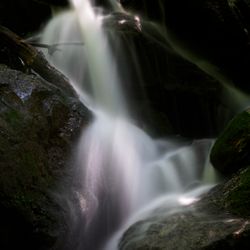
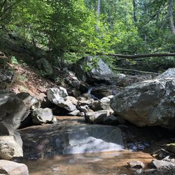
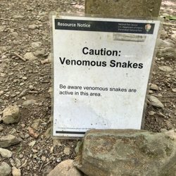
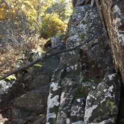
Compton Gap Parking Area Photos


You might also consider
More like Compton Gap Parking Area
Recommended Reviews - Compton Gap Parking Area
Start your review...

7 years ago
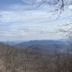
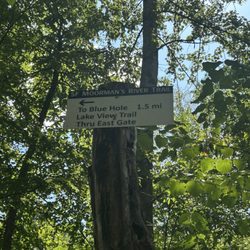
If you're looking for trees, fresh air wilderness and critters in a walking trail form. Well you're in luck buddy! This is a trail for you. It has it all! A path to walk, trees, wilderness, critters and fresh air. If you're looking to stay inside, well then this probably isn't for you. Also if you enjoy going to the bathroom outside then you're set. Downside is this outdoor walking trail is not air conditioned and the trail isn't an escalator so you actually have to use your legs. So there's that. This walrus gives this trail a tusk and a half. read more
11 years ago
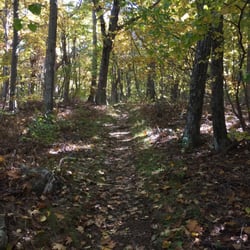
This loop we hiked today at Compton Gap had no vistas but man was it perfect. Walking trail was moderate and the multi-colored leaves littered the ground beautifully. So many great spots to stop and spread a blanket. Most people went to the West side across the road but we took East and loved the tranquility. read more
More info about Compton Gap Parking Area
Skyline Druve
Milepost 11
Front Royal, VA 22630
Directions
(540) 999-3500
Call Now
Hours
Outdoor Amenities


Compton Gap Parking Area - hiking - Updated July 2026
Best of Front Royal
People found Compton Gap Parking Area by searching for…
Hiking Trails in Front Royal, VA
Hiking With Kids in Front Royal, VA
Things to Do in Front Royal, VA
Walking Trails in Front Royal, VA
Scenic Overlook in Front Royal, VA
Scenic View in Front Royal, VA
Fun Things to Do With Kids in Front Royal, VA
Lookout Points in Front Royal, VA
Things to Do at Night in Front Royal, VA
Running Trails in Front Royal, VA
View Points in Front Royal, VA
Hiking Trails Kid Friendly in Front Royal, VA
Off Road Trails in Front Royal, VA
River Swimming in Front Royal, VA
Lakes & Ponds in Front Royal, VA
Swimming Lakes in Front Royal, VA
Swimming Holes in Front Royal, VA
Places to Take Pictures in Front Royal, VA
Trending Searches in Front Royal, VA
Boat Tours near Compton Gap Parking Area
Cliff Jumping near Compton Gap Parking Area
Cruising Spots near Compton Gap Parking Area
Day Trips near Compton Gap Parking Area
Dog Friendly Things To Do near Compton Gap Parking Area
Dog Swimming near Compton Gap Parking Area
Kayak Rental near Compton Gap Parking Area
Kids Activities Indoor near Compton Gap Parking Area
Lakes near Compton Gap Parking Area
Off Road Trails near Compton Gap Parking Area
Outdoor Activities near Compton Gap Parking Area
Peach Picking near Compton Gap Parking Area
Picnic near Compton Gap Parking Area
Public Shower near Compton Gap Parking Area
Rainy Day Activities near Compton Gap Parking Area
River Swimming near Compton Gap Parking Area
Rock Quarry near Compton Gap Parking Area
Scenic Overlook near Compton Gap Parking Area
Swimming Holes near Compton Gap Parking Area
Swimming Lakes near Compton Gap Parking Area
Things To Do On A Rainy Day near Compton Gap Parking Area
Tubing near Compton Gap Parking Area
U Pick Farms near Compton Gap Parking Area
View Points near Compton Gap Parking Area
Watch Sunset near Compton Gap Parking Area
Browse Articles
Browse Nearby
BEST of Front Royal, Virginia Scenic View near Compton Gap Parking Area
BEST of Front Royal, Virginia Restaurants near Compton Gap Parking Area
BEST of Front Royal, Virginia Coffee near Compton Gap Parking Area
BEST of Front Royal, Virginia Things to Do near Compton Gap Parking Area
BEST of Front Royal, Virginia Parks near Compton Gap Parking Area
BEST of Front Royal, Virginia Breakfast near Compton Gap Parking Area
BEST of Front Royal, Virginia Caves near Compton Gap Parking Area
BEST of Front Royal, Virginia Campgrounds near Compton Gap Parking Area
BEST of Front Royal, Virginia Visitor Centers near Compton Gap Parking Area
Browse Brands
Related Searches in Front Royal, VA
Affordable Kayak Rental Services in Front Royal, Virginia
Best Dog Hiking Trails Around Front Royal, Virginia
Best Fishing Locations and Guides in Front Royal, Virginia
Best Places for Horseback Riding in Front Royal, Virginia
Best Waterfalls and Swimming Holes in Front Royal, Virginia
Check Out Off Road Trails in Front Royal, Virginia
Discover Dog Friendly Trails to Explore in Front Royal, Virginia
Discover Easy Hiking Trails Near Front Royal, Virginia
Discover Popular Bike Trails in Front Royal, Virginia
Discover Scenic Mountain Bike Trails Near Front Royal, Virginia
Discover a Hiking Trail in Front Royal, Virginia
Discover the Best Night Hike Trails in Front Royal, Virginia
Dog-Friendly Hikes With Dogs in Front Royal, Virginia
Enjoy Camping Adventures Around Front Royal, Virginia
Enjoy Kayaking Adventures in Front Royal, Virginia
Enjoy Off Leash Dog Hikes in Front Royal, Virginia
Enjoy Tent Camping Spots Around Front Royal, Virginia
Enjoy a Beautiful Waterfall Hike in Front Royal, Virginia
Enjoy the Best Walking Trails in Front Royal, Virginia
Explore Beautiful Parks and Green Spaces in Front Royal, Virginia
Explore Easy Hikes Perfect for All in Front Royal, Virginia
Explore Fun Activities to Do in Front Royal, Virginia
Explore Popular Campgrounds Near Front Royal, Virginia
Explore Popular State Park Destinations in Front Royal, Virginia
Explore Scenic Lakes to Visit in Front Royal, Virginia
Explore Top Dog Parks in Front Royal, Virginia Near You
Explore Top Water Parks in Front Royal, Virginia Today
Explore the Best Boating Spots in Front Royal, Virginia
Explore the Best Swimming Holes Around Front Royal, Virginia
Family Friendly Hiking With Kids in Front Royal, Virginia
Find Popular Ziplining Spots Around Front Royal, Virginia
Find Top Dog Swimming Spots in Front Royal, Virginia
Find Top-Rated Waterfalls in Front Royal, Virginia Now
Find the Best Playgrounds to Visit in Front Royal, Virginia
Hiking Trails With Waterfalls in Front Royal, Virginia
Off Leash Dog Hiking Trails in Front Royal, Virginia
Plan a Scenic Drive Route Near Front Royal, Virginia
Popular Outdoor Activities to Try in Front Royal, Virginia
Popular Picnic Spots to Visit in Front Royal, Virginia
Safe River Swimming Areas in Front Royal, Virginia
Safe and Fun Parks for Kids in Front Royal, Virginia
Top Dog Friendly Things to Do in Front Royal, Virginia
Top Hiking Trails to Explore in Front Royal, Virginia
Top Running Trails to Explore in Front Royal, Virginia
Top Swimming Lakes to Enjoy in Front Royal, Virginia
Top Swimming Spots and Pools in Front Royal, Virginia


