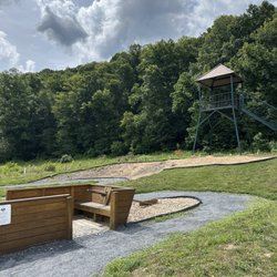
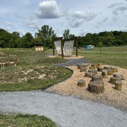
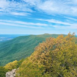
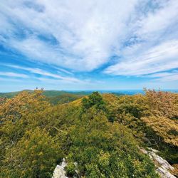
Duncan Knob Photos

You might also consider
More like Duncan Knob
Recommended Reviews - Duncan Knob
Start your review...

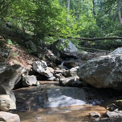
14 years ago
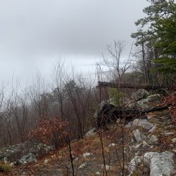
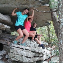
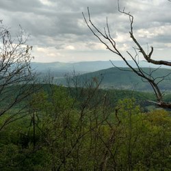
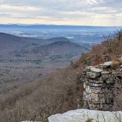
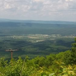
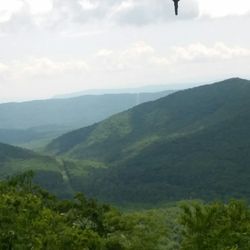
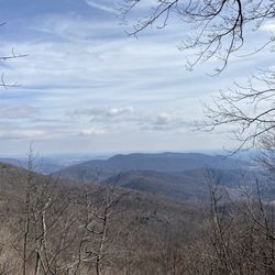
A moderate 5-6 mile hike with a rock scramble and nice views at the summit. Located in the Massanutten Mountains in the GWNF, the trailhead to Scothorn Gap Trail can be easily found off of Crisman Hollow Road. Due to time constraints we were only able to hike out to Duncan Knob and back rather than do the entire loop including Strickler Knob but it was still a pleasant hike. The climb early on reminded me I need to hit the Stairmaster more often at the gym. Parts of the trail are quite overgrown so make sure to check yourselves quite thoroughly during tick season. We found PLENTY on our legs. The climb up the rocks to the summit was a LOT of fun, though maybe not so for those with balance problems or fear of heights. (I have to admit it was kind of intimidating looking up from the bottom - we have to go up THERE??) But once you climb, the view you are greeted with is wonderful and there is a nice flat, albeit small, area on the summit to hang out. Ran into only one group of hikers who patiently waited for us to descend from the rocks for their turn at the summit. Look forward to doing this again in the fall and also taking on Strickler Knob. For more info and a map go here: http://www.hikingupward.com/GWNF/DuncanKnob/index.asp read more
More info about Duncan Knob
Edinburg, VA 22824
Directions
Hours
Outdoor Amenities


Duncan Knob - hiking - Updated July 2026
Best of Edinburg
People found Duncan Knob by searching for…
Off Road Trails in Edinburg, VA
Waterfall Hike in Edinburg, VA
Running Trails in Edinburg, VA
Walking Trails in Edinburg, VA
Swimming Holes in Edinburg, VA
Fun Things to Do at Night in Edinburg, VA
Lookout Points in Edinburg, VA
River Swimming in Edinburg, VA
Places to Take Pictures in Edinburg, VA
Swimming Lakes in Edinburg, VA
Off Leash Dog Hikes in Edinburg, VA
Trending Searches in Edinburg, VA
Browse Articles
Browse Nearby
Browse Brands
Related Searches in Edinburg, VA
Affordable Kayak Rental Services in Edinburg, Virginia
Best Dog Hiking Trails Around Edinburg, Virginia
Best Fishing Locations and Guides in Edinburg, Virginia
Best Fun Things to Do in Edinburg, Virginia
Best Places for Horseback Riding in Edinburg, Virginia
Check Out Off Road Trails in Edinburg, Virginia
Discover Dog Friendly Trails to Explore in Edinburg, Virginia
Discover Popular Photo Spots in Edinburg, Virginia
Discover a Hiking Trail in Edinburg, Virginia
Discover the Best Beaches in Edinburg, Virginia
Discover the Best Night Hike Trails in Edinburg, Virginia
Dog-Friendly Hikes With Dogs in Edinburg, Virginia
Enjoy Off Leash Dog Hikes in Edinburg, Virginia
Enjoy the Best Tubing Experiences in Edinburg, Virginia
Enjoy the Best Walking Trails in Edinburg, Virginia
Explore Beautiful Botanical Gardens in Edinburg, Virginia
Explore Beautiful Parks and Green Spaces in Edinburg, Virginia
Explore Bike Rentals Throughout Edinburg, Virginia
Explore Easy Hikes Perfect for All in Edinburg, Virginia
Explore Family-Friendly Zoos and Wildlife in Edinburg, Virginia
Explore Free Things to Do Around Edinburg, Virginia
Explore Fun Activities to Do in Edinburg, Virginia
Explore Popular Campgrounds Near Edinburg, Virginia
Explore Popular RV Parks Around Edinburg, Virginia
Explore Popular View Points Around Edinburg, Virginia
Explore Scenic Lakes to Visit in Edinburg, Virginia
Explore Top Dog Parks in Edinburg, Virginia Near You
Explore Top Water Parks in Edinburg, Virginia Today
Explore the Best Boating Spots in Edinburg, Virginia
Explore the Best Swimming Holes Around Edinburg, Virginia
Family Friendly Hiking With Kids in Edinburg, Virginia
Find Beautiful Views in Edinburg, Virginia
Find Fun Things to Do With Kids in Edinburg, Virginia
Find Popular Ziplining Spots Around Edinburg, Virginia
Find Top-Rated Disc Golf in Edinburg, Virginia
Find Top-Rated Waterfalls in Edinburg, Virginia Now
Find the Best Playgrounds to Visit in Edinburg, Virginia
Find the Best Scenic View Locations in Edinburg, Virginia
Hiking Trails With Waterfalls in Edinburg, Virginia
Off Leash Dog Hiking Trails in Edinburg, Virginia
Perfect Spots to Watch Sunset in Edinburg, Virginia
Popular Kids Activities in Edinburg, Virginia
Popular Things to Do in Edinburg, Virginia
Top Hiking Trails to Explore in Edinburg, Virginia
Top Running Trails to Explore in Edinburg, Virginia
Top Swimming Lakes to Enjoy in Edinburg, Virginia
Top Things to Do With Kids in Edinburg, Virginia


