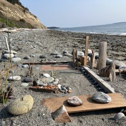
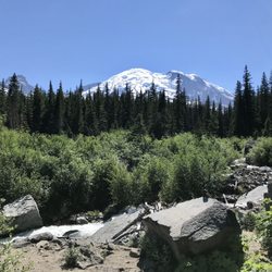
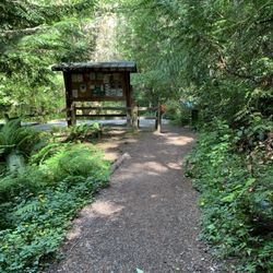
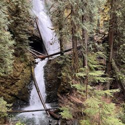
Centennial Trail Photos


You might also consider
More like Centennial Trail
Recommended Reviews - Centennial Trail
Start your review...

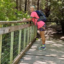
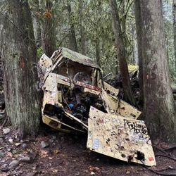
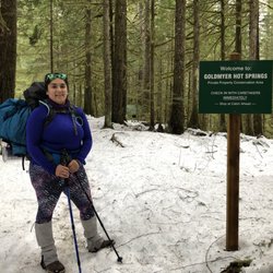
Reviews With Photos

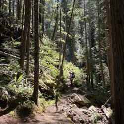
I started this trail in Arlington and set out towards Snohomish. I was on a road bike. I hit several areas along the way where the sidewalks were closed due to construction. There were also lots of tree roots that have upheaved the asphalt. All slightly treacherous on a road bike! The worst spot was at a very dangerous railroad crossing that you don't see coming where I ended up on the ground! Scary! After all this I went approximately 4 miles and the trail was closed! So then I got to turn around and go back through the mess again! I cruised North through Bryant and to the barn. It was much better and truly beautiful! Even saw a black bear on the trail. There was several spots with bathrooms and benches. The area in downtown Arlington had some interesting artwork to see. A few homeless however do seem to hangout here. Parking was great in several locations as well. It was wonderful to see so many people exercising!

This trail is 30 miles long. It starts just north of Arlington and goes all the way to Snohomish. Nice and paved all the way. Mostly flat and easy. You can walk, bike, or even ride your horse on this trail. There are several places to park along the route. Each parking area has porta potties. There are also benches along the route as well for if you need a rest. Just a really nice trail. I love how they repurpose old rail routes and turn them into trails.

Wide, paved trail that is well maintained. Great for all types of activities, walking, running, biking, rollerblading, etc. Family and dog friendly. There are many places aling the trail you can start -- go to the Centennial Trail website for the map. 4 stars because, like people mentioned before, some people just don't understand how to share the trail!

I've biked the thirty miles of this trail a few times and have always enjoyed it. The Pros: It's flat. Used to be a railroad flat. Makes it easy to pedal and pedal for miles and miles. There's real bathrooms at a few stops on the trail that are clean and well-maintained. There's more than a few pretty good restaurants at various points in the trail. The north end trailhead is the Nakashima Heritage Barn which offers an important look at the Japanese American experience in the Pacific NW. It's pretty and peaceful. The Cons: There are a few road crossings and the area drivers don't seem to love or stop for cyclists. It gets busy with both zip through at 20 mph cyclists and kids weaving around, which can be nerve wracking. A number of unshaded areas make it get pretty hot on the trail. Also, watch out for the railroad tracks - they mean it when they say to dismount - I took one of my biggest spills to date here. My fault, not the tracks fault. read more


6 years ago
6 years ago
I started this trail in Arlington and set out towards Snohomish. I was on a road bike. I hit several areas along the way where the sidewalks were closed due to construction. There were also lots of tree roots that have upheaved the asphalt. All slightly treacherous on a road bike! The worst spot was at a very dangerous railroad crossing that you don't see coming where I ended up on the ground! Scary! After all this I went approximately 4 miles and the trail was closed! So then I got to turn around and go back through the mess again! I cruised North through Bryant and to the barn. It was much better and truly beautiful! Even saw a black bear on the trail. There was several spots with bathrooms and benches. The area in downtown Arlington had some interesting artwork to see. A few homeless however do seem to hangout here. Parking was great in several locations as well. It was wonderful to see so many people exercising! read more


This trail is 30 miles long. It starts just north of Arlington and goes all the way to Snohomish. Nice and paved all the way. Mostly flat and easy. You can walk, bike, or even ride your horse on this trail. There are several places to park along the route. Each parking area has porta potties. There are also benches along the route as well for if you need a rest. Just a really nice trail. I love how they repurpose old rail routes and turn them into trails. read more

8 years ago
7 years ago
14 years ago
18 years ago
10 years ago
Wide, paved trail that is well maintained. Great for all types of activities, walking, running, biking, rollerblading, etc. Family and dog friendly. There are many places aling the trail you can start -- go to the Centennial Trail website for the map. 4 stars because, like people mentioned before, some people just don't understand how to share the trail! read more


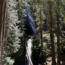
I've been using this trail since my kids were in strollers, about 15 years ago. Back then the trail didn't go much past the Machias station rest stop from its beginning in Snohomish. Now the trail goes uninterrupted all the way to Arlington and is projected to be completed all the way to the Skagit County line sometime this year (2011). This is a gorgeous trail through semi-rural countryside and even a lake, Lake Cassidy. It's paved and the pavement is in great condition, plenty wide for multiple use, even a softer unpaved side for the equestrians. The trail is relatively flat with some gentle grades, almost unnoticeable. The trail has several access points with parking. I just completed a 35 mile bicycle ride (17.5 miles out & back) over Memorial Day weekend and it was not very crowded at all. In fact, at times I saw no one on the trail. It does get more crowded in the summer. Try the Beetle Juice & Java Cafe right there at the very start of the trail in Snohomish for some of the tastiest smoothies ever, a great post-ride refresher. read more


13 years ago
More info about Centennial Trail
Ask the Community - Centennial Trail
Review Highlights - Centennial Trail
You might also consider


Centennial Trail - hiking - Updated July 2026
Best of Snohomish
People found Centennial Trail by searching for…
Lakes in Snohomish, Washington
Parks in Snohomish, Washington
Walking Trails in Snohomish, Washington
Beautiful Views in Snohomish, Washington
Watch Sunset in Snohomish, Washington
Hiking Trails in Snohomish, Washington
Running Trails in Snohomish, Washington
Hiking With Kids in Snohomish, Washington
Dog Friendly Hiking Trails in Snohomish, Washington
Fun Things to Do With Kids in Snohomish, Washington
Easy Hikes in Snohomish, Washington
Scenic View in Snohomish, Washington
Off Road Trails in Snohomish, Washington
Stroller Friendly Hikes in Snohomish, Washington
Parks for Kids in Snohomish, Washington
Lookout Points in Snohomish, Washington
Sunset View in Snohomish, Washington
Bike Paths in Snohomish, Washington
Scenic Overlook in Snohomish, Washington
Off Leash Dog Hiking Trails in Snohomish, Washington
Stroller Walk in Snohomish, Washington
Trails in Snohomish, Washington
Trending Searches in Snohomish, WA
4th Of July Fireworks near Centennial Trail
Black Owned Nail Salons near Centennial Trail
Boat Rental near Centennial Trail
Cliff Jumping near Centennial Trail
Day Trips near Centennial Trail
Dog Friendly Trails near Centennial Trail
Fireworks near Centennial Trail
Jet Ski Rental near Centennial Trail
Kayak Rental near Centennial Trail
Lakes & Ponds near Centennial Trail
Outdoor Activities near Centennial Trail
Parks For Picnics near Centennial Trail
Places To Walk Around near Centennial Trail
Public Pools near Centennial Trail
Public Shower near Centennial Trail
River Swimming near Centennial Trail
Rock Quarry near Centennial Trail
Scenic Night View near Centennial Trail
Scenic Overlook near Centennial Trail
Secluded Spots near Centennial Trail
Soccer Store near Centennial Trail
Splash Pad near Centennial Trail
Strawberry Picking near Centennial Trail
Sunrise View near Centennial Trail
Swimming Holes near Centennial Trail
Swimming Lakes near Centennial Trail
Watch Sunset near Centennial Trail
Browse Articles
Browse Nearby
BEST of Snohomish, Washington Coffee near Centennial Trail
BEST of Snohomish, Washington Restaurants near Centennial Trail
BEST of Snohomish, Washington Things to Do near Centennial Trail
BEST of Snohomish, Washington Breakfast near Centennial Trail
BEST of Snohomish, Washington Walking Trails near Centennial Trail
BEST of Snohomish, Washington Parks near Centennial Trail
BEST of Snohomish, Washington Campgrounds near Centennial Trail
Browse Brands
Related Searches in Snohomish, WA
Affordable Kayak Rental Services in Snohomish, Washington
Best Fishing Locations and Guides in Snohomish, Washington
Best Nature Trails for Hiking in Snohomish, Washington
Best Places for Horseback Riding in Snohomish, Washington
Check Out Off Road Trails in Snohomish, Washington
Discover Dog Friendly Trails to Explore in Snohomish, Washington
Discover Scenic Mountain Bike Trails Near Snohomish, Washington
Discover Top Nature Parks to Visit in Snohomish, Washington
Discover Walking Parks in Snohomish, Washington Near You
Discover a Hiking Trail in Snohomish, Washington
Discover the Best Night Hike Trails in Snohomish, Washington
Dog-Friendly Hikes With Dogs in Snohomish, Washington
Enjoy Camping Adventures Around Snohomish, Washington
Enjoy Exciting Mountain Biking Adventures in Snohomish, Washington
Enjoy Tent Camping Spots Around Snohomish, Washington
Enjoy Water Activities and Fun in Snohomish, Washington
Enjoy a Beautiful Waterfall Hike in Snohomish, Washington
Enjoy the Best Picnic Spots and Ideas in Snohomish, Washington
Enjoy the Best Walking Path in Snohomish, Washington
Enjoy the Best Walking Trails in Snohomish, Washington
Exciting Cliff Jumping Spots in Snohomish, Washington
Explore Beautiful Parks and Green Spaces in Snohomish, Washington
Explore Easy Hikes Perfect for All in Snohomish, Washington
Explore Fun Activities to Do in Snohomish, Washington
Explore Popular Campgrounds Near Snohomish, Washington
Explore the Best Beach Spots in Snohomish, Washington
Explore the Best Boating Spots in Snohomish, Washington
Explore the Best Swimming Holes Around Snohomish, Washington
Find Beautiful Views in Snohomish, Washington
Find Parks and Recreation Activities in Snohomish, Washington
Find Popular Ziplining Spots Around Snohomish, Washington
Find the Best Parks for Picnics in Snohomish, Washington
Find the Best Scenic View Locations in Snohomish, Washington
Hiking Trails With Waterfalls in Snohomish, Washington
Off Leash Dog Hiking Trails in Snohomish, Washington
Picnic Areas With BBQ Pits Available in Snohomish, Washington
Plan a Scenic Drive Route Near Snohomish, Washington
Popular Fishing Spots to Explore in Snohomish, Washington
Popular Outdoor Activities to Try in Snohomish, Washington
Popular Picnic Spots to Visit in Snohomish, Washington
Popular Things to Do in Snohomish, Washington
Safe River Swimming Areas in Snohomish, Washington
Safe and Fun Parks for Kids in Snohomish, Washington
Top Climbing Spots and Gyms in Snohomish, Washington
Top Paddleboarding Activities in Snohomish, Washington
Top Playgrounds for Kids to Enjoy in Snohomish, Washington
Top Running Trails to Explore in Snohomish, Washington
Top Swimming Lakes to Enjoy in Snohomish, Washington