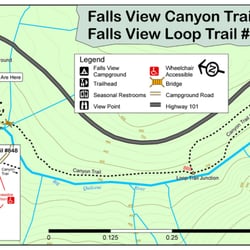
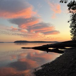
Murhut Falls Photos


More like Murhut Falls
Recommended Reviews - Murhut Falls
Start your review...

1 year ago
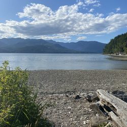
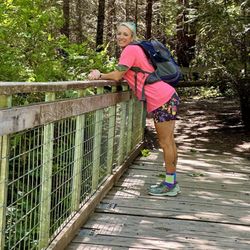
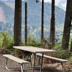
One of my favorite waterfalls in Washington. Great trail and drive up to the trail. You park and turn around, and the trail is right there. I wish there was a sign because you'll get asked a lot, "Is that the trail?" To access the waterfall, if you want to get great shots of the waterfall, you have to climb down to it. We weren't able to because we have an 8-month-old. But we used to climb down to the waterfall years ago. It's a must! Our first time at this hike was 6 years ago, and we've done it a handful of times since then. I do want to say every time we have come there, there are hardly any people on the trail. Most people will scramble down by the waterfall. It's fun. You do see people turn around at the tree/bench because it's a steep climb down. But you are able to still see the waterfall. Parking: There are about maybe 10 cars that can fit, and then parking a couple of feet ahead. Restroom: None read more


3 years ago
Such a nice hike. Very lush foliage and trees, and is a short out and back, roughly 1.6 miles. Very low elevation gain, family and dog friendly. There is some parking available right across from the trailhead. There are a lot of small fallen trees, probably due to that huge windstorm that happened a couple weeks ago. There is one tree you will have to climb over. I'm 5'0 and it was tall enough where I was almost sitting on it when I walked over it. And best of all the waterfall is spectacular! Definitely won't disappoint. I don't know how it is in the summer. There are also smaller water falls you can see on the way there. read more

More info about Murhut Falls
NF-2530
Brinnon, WA 98320
Directions
Hours
Outdoor Amenities


Murhut Falls - hiking - Updated June 2026
Best of Brinnon
People found Murhut Falls by searching for…
Hiking Trails With Waterfalls in Brinnon, Washington
Things to Do in Brinnon, Washington
Dog Friendly Hiking Trails in Brinnon, Washington
Waterfalls and Swimming Holes in Brinnon, Washington
Secret Spots in Brinnon, Washington
Waterfalls in Brinnon, Washington
Hikes With Dogs in Brinnon, Washington
Walking Trails in Brinnon, Washington
Easy Hikes in Brinnon, Washington
Beautiful Views in Brinnon, Washington
Running Trails in Brinnon, Washington
Fun Things to Do With Kids in Brinnon, Washington
Redwood Trees in Brinnon, Washington
Lookout Points in Brinnon, Washington
Off Road Trails in Brinnon, Washington
Scenic Views in Brinnon, Washington
Off Leash Dog Hiking Trails in Brinnon, Washington
View Points in Brinnon, Washington
Hidden Gems in Brinnon, Washington
Secluded Spots in Brinnon, Washington
Trending Searches in Brinnon, WA
Black Owned Nail Salons near Murhut Falls
Cliff Jumping near Murhut Falls
Dog Friendly Trails near Murhut Falls
Fishing Spots near Murhut Falls
Jet Ski Rental near Murhut Falls
Kayak Rental near Murhut Falls
Lakes & Ponds near Murhut Falls
Outdoor Activities near Murhut Falls
Places To Walk Around near Murhut Falls
Public Pools near Murhut Falls
Public Shower near Murhut Falls
River Swimming near Murhut Falls
Scenic Night View near Murhut Falls
Scenic Overlook near Murhut Falls
Secluded Spots near Murhut Falls
Soccer Store near Murhut Falls
Strawberry Picking near Murhut Falls
Sunrise View near Murhut Falls
Swimming Holes near Murhut Falls
Swimming Lakes near Murhut Falls
Browse Brands
Related Searches in Brinnon, WA
Affordable Kayak Rental Services in Brinnon, Washington
Best Fishing Locations and Guides in Brinnon, Washington
Best Places for Horseback Riding in Brinnon, Washington
Best Waterfalls and Swimming Holes in Brinnon, Washington
Check Out Off Road Trails in Brinnon, Washington
Discover Dog Friendly Trails to Explore in Brinnon, Washington
Discover Scenic Mountain Bike Trails Near Brinnon, Washington
Discover Scenic Waterfall Spots in Brinnon, Washington
Discover Top Nature Parks to Visit in Brinnon, Washington
Discover Walking Parks in Brinnon, Washington Near You
Discover a Hiking Trail in Brinnon, Washington
Discover the Best Night Hike Trails in Brinnon, Washington
Dog-Friendly Hikes With Dogs in Brinnon, Washington
Enjoy Camping Adventures Around Brinnon, Washington
Enjoy Kayaking Adventures in Brinnon, Washington
Enjoy Tent Camping Spots Around Brinnon, Washington
Enjoy a Beautiful Waterfall Hike in Brinnon, Washington
Enjoy the Best Picnic Spots and Ideas in Brinnon, Washington
Enjoy the Best Walking Path in Brinnon, Washington
Enjoy the Best Walking Trails in Brinnon, Washington
Exciting Cliff Jumping Spots in Brinnon, Washington
Experience Thrilling White Water Rafting in Brinnon, Washington
Explore Beautiful Parks and Green Spaces in Brinnon, Washington
Explore Easy Hikes Perfect for All in Brinnon, Washington
Explore Fun Activities to Do in Brinnon, Washington
Explore Popular Campgrounds Near Brinnon, Washington
Explore the Best Beach Spots in Brinnon, Washington
Explore the Best Trail Options in Brinnon, Washington
Family Friendly Hiking With Kids in Brinnon, Washington
Find Popular Ziplining Spots Around Brinnon, Washington
Find the Best Parks for Picnics in Brinnon, Washington
Find the Best Scenic View Locations in Brinnon, Washington
Great Places to Walk in Brinnon, Washington
Hike the Popular Waterfall Trail in Brinnon, Washington
Hiking Trails With Waterfalls in Brinnon, Washington
Off Leash Dog Hiking Trails in Brinnon, Washington
Plan a Scenic Drive Route Near Brinnon, Washington
Popular Outdoor Activities to Try in Brinnon, Washington
Popular Picnic Spots to Visit in Brinnon, Washington
Safe River Swimming Areas in Brinnon, Washington
Safe and Fun Parks for Kids in Brinnon, Washington
Top Climbing Spots and Gyms in Brinnon, Washington
Top Paddleboarding Activities in Brinnon, Washington
Top Playgrounds for Kids to Enjoy in Brinnon, Washington
Top Running Trails to Explore in Brinnon, Washington
Top Swimming Lakes to Enjoy in Brinnon, Washington
Top Swimming Spots and Pools in Brinnon, Washington
Top Things to Do With Kids in Brinnon, Washington