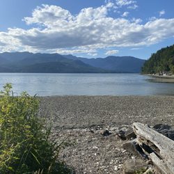
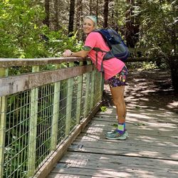
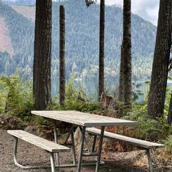
Rocky Brooks Falls Photos


More like Rocky Brooks Falls
Recommended Reviews - Rocky Brooks Falls
Start your review...

Reviews With Photos


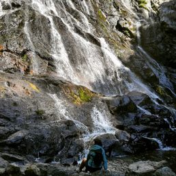
The hike was short on a gravel path. Once you reach the falls, there are large boulders to climb over but it was not difficult. There is a shallow area of water at the base of the falls (perfect for little kids to play in). There is also a deep pool of water where people were swimming that is connected to the shallow area. There are danger signs posted at the trail head so swim at your own risk. Loved it, will definitely go back!


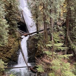
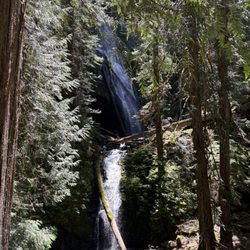
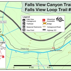
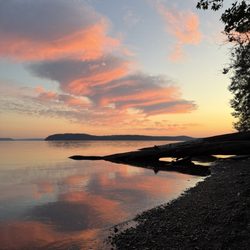
This is my kind of "hike": Drive 3 miles outside of a town, pull off the side of the road, walk two "nature" blocks, enjoy a wonderful waterfall! We visited on a rainy January day and only saw two groups of people visit. It is easy to pass by so read my thorough directions below. The falls appeared much larger than I expected and pictures show. This makes it well worth the mini 15 minute side trip as you drive in Hwy 101 along the Hood Canal. The walk isn't really considered a hike and is doable by all ages. Directions: A mile north of Brinnon and a few streets from Dosewallips State Park, turn westbound of Dosewallips Road. Continue roughly 3 miles until you go over a small bridge (Rocky Brook River) with a Hydroelectric Station to your right. Pull over into the small lot to your left and park your car. Follow the river and your ears to the falls. Warning: Beware of extreme changes in water levels as the signs heed. I would NOT recommend swimming here. The water flow is was visibly changing drastically in front of our eyes. Also be cautious of all the oddly shaped and slippery rocks at the base of the falls.


Pull off the road when you see the Rocky Brook Hydroelectric power building. The "hike" to the waterfall begins there and is about 1 block. Beautiful! Ages-1-100 You could even bring a stroller 90% of the way. Bonus- Tons of rocks to climb on and explore. A possible swimming hole if the weather is hot.

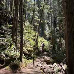
I was staying on the peninsula for work. However, I had the later shift, so I had time to explore during the day. Searching for waterfalls with easy access, I found Rocky Brook Falls! A few minutes drive off of 101 in Brinnon, WA you'll find Rocky Brook Falls. Across the street are a few parking spots, but beware that side is private property and there are a bunch of no trespassing signs. The entrance to the trail was not obvious to me. So I took some photos showing the path. But it's a short walk to the falls, which by the way, was a lot larger than I thought it would be! You will have to climb over some boulders to access the pool at the base of the falls, so just be aware of that. I came on a summer weekday, so there was only another couple with their dog there. You practically had the place to yourself! It has been one of the dryer summers, so I imagine after a good rainfall, the falls would be roaring and serene. Also note, there are no bathroom facilities and no cell service in the immediate area. read more


What an easy hike to an unpopulated waterfall with wading, swimming, and jumping options. I don't think it gets better than this for a hidden treasure. I highly recommend. Bring some Keens or other water shoes as you have to scrabble over some larger boulders at the edge of the pool - but to keep it real, I wore flip flops. There is a dirt parking lot on left side . Cross over the road and hike the trail on the right side. read more


11 months ago
Best day of our trip was here at Rocky Brook Falls! It was so easy to get to, and had beautiful, clean, refreshingly cold water. We stayed and played in the water and the kids wanted to go back the next day! read more


3 years ago
What a relaxing place right off Highway 101. We've visited the falls twice and would highly recommend this oasis. The walk is easy to the falls and parking is sufficient. 5 Stars plus. read more


3 years ago
Short walk to a beautiful waterfall. It gets crowded, and you may wanna consider some good hiking shoes as when you get to the falls, there are slippery rocks and tree roots. read more
4 years ago
Such an amazing location for maternity photos. You pull off the Highway and the spot is maybe a three minute walk from the road. Perfect for anyone who can't handle huge hikes but wants to experience a beautiful waterfall. read more


3 years ago
The hike was short on a gravel path. Once you reach the falls, there are large boulders to climb over but it was not difficult. There is a shallow area of water at the base of the falls (perfect for little kids to play in). There is also a deep pool of water where people were swimming that is connected to the shallow area. There are danger signs posted at the trail head so swim at your own risk. Loved it, will definitely go back! read more


5 years ago
Hidden gem near Dosewalips Campground. Small parking lot. Easy trail to waterfalls. Busy. Beautiful photo ops. Be sure you are ready to have water spraying on you if you get close. Be careful on rocks. read more

This is my kind of "hike": Drive 3 miles outside of a town, pull off the side of the road, walk two "nature" blocks, enjoy a wonderful waterfall! We visited on a rainy January day and only saw two groups of people visit. It is easy to pass by so read my thorough directions below. The falls appeared much larger than I expected and pictures show. This makes it well worth the mini 15 minute side trip as you drive in Hwy 101 along the Hood Canal. The walk isn't really considered a hike and is doable by all ages. Directions: A mile north of Brinnon and a few streets from Dosewallips State Park, turn westbound of Dosewallips Road. Continue roughly 3 miles until you go over a small bridge (Rocky Brook River) with a Hydroelectric Station to your right. Pull over into the small lot to your left and park your car. Follow the river and your ears to the falls. Warning: Beware of extreme changes in water levels as the signs heed. I would NOT recommend swimming here. The water flow is was visibly changing drastically in front of our eyes. Also be cautious of all the oddly shaped and slippery rocks at the base of the falls. read more

 - Hiking Near Me - Brinnon, Washington")


11 years ago
Pull off the road when you see the Rocky Brook Hydroelectric power building. The "hike" to the waterfall begins there and is about 1 block. Beautiful! Ages-1-100 You could even bring a stroller 90% of the way. Bonus- Tons of rocks to climb on and explore. A possible swimming hole if the weather is hot. read more

9 years ago
This is a short, easy walk to beautiful falls! You walk along a stream under the shade of mossy trees. The falls are incredible. It's quite rocky at the base of the falls and you have to do a little climbing to get right next to them. But the falls can be viewed without the climb as well! read more

If you happen to pass through Brinnon, WA or are camping at Dosewallips, be sure to stop at Rocky Brooks. It's a quick little hike (5-10 minutes depending on your group's pace) to get to the bottom of the waterfall. The pros are it is quick and beautiful. Cons, it can be a bit muddy and hard to locate. There are no road signs to tell you that you made it. Look for the location using google maps or GPS and you'll find a place to the left of the road for dirt parking. read more


7 years ago
7 years ago
8 years ago
8 years ago
More info about Rocky Brooks Falls
3000 Dosewallips Road
Brinnon, WA 98320
Directions
Hours
Outdoor Amenities
Ask the Community - Rocky Brooks Falls
Review Highlights - Rocky Brooks Falls


Why does Yelp recommend reviews?
1 review that is not currently recommended
The reviews below are not factored into the business's overall star rating.
6 years ago
Rocky Brooks Falls - hiking - Updated June 2026
Best of Brinnon
People found Rocky Brooks Falls by searching for…
Hiking Trails With Waterfalls in Brinnon, Washington
Things to Do in Brinnon, Washington
River Swimming in Brinnon, Washington
Easy Hikes in Brinnon, Washington
Fishing in Brinnon, Washington
Walking Trails in Brinnon, Washington
Waterfalls in Brinnon, Washington
Photo Spots in Brinnon, Washington
Off Road Trails in Brinnon, Washington
Beautiful Views in Brinnon, Washington
Swimming Lakes in Brinnon, Washington
Places to Take Pictures in Brinnon, Washington
Parks for Kids in Brinnon, Washington
Secret Spots in Brinnon, Washington
Attractions in Brinnon, Washington
Hiking With Kids in Brinnon, Washington
Stroller Friendly Hikes in Brinnon, Washington
Swimming in Brinnon, Washington
Natural Hot Springs in Brinnon, Washington
Tourist Attractions in Brinnon, Washington
State Parks in Brinnon, Washington
Trending Searches in Brinnon, WA
Black Owned Nail Salons near Rocky Brooks Falls
Boat Rental near Rocky Brooks Falls
Cliff Jumping near Rocky Brooks Falls
Creeks near Rocky Brooks Falls
Day Trips near Rocky Brooks Falls
Dog Friendly Trails near Rocky Brooks Falls
Fireworks near Rocky Brooks Falls
Fishing Spots near Rocky Brooks Falls
Jet Ski Rental near Rocky Brooks Falls
Kayak Rental near Rocky Brooks Falls
Lakes & Ponds near Rocky Brooks Falls
Outdoor Activities near Rocky Brooks Falls
Places To Walk Around near Rocky Brooks Falls
Public Pools near Rocky Brooks Falls
Public Shower near Rocky Brooks Falls
River Swimming near Rocky Brooks Falls
Rock Quarry near Rocky Brooks Falls
Scenic Night View near Rocky Brooks Falls
Scenic Overlook near Rocky Brooks Falls
Secluded Spots near Rocky Brooks Falls
Soccer Store near Rocky Brooks Falls
Splash Pad near Rocky Brooks Falls
Strawberry Picking near Rocky Brooks Falls
Sunrise View near Rocky Brooks Falls
Swimming Holes near Rocky Brooks Falls
Swimming Lakes near Rocky Brooks Falls
Watch Sunset near Rocky Brooks Falls
Browse Articles
Browse Nearby
Browse Brands
Related Searches in Brinnon, WA
Affordable Kayak Rental Services in Brinnon, Washington
Best Fishing Locations and Guides in Brinnon, Washington
Best Places for Horseback Riding in Brinnon, Washington
Best Waterfalls and Swimming Holes in Brinnon, Washington
Check Out Off Road Trails in Brinnon, Washington
Discover Dog Friendly Trails to Explore in Brinnon, Washington
Discover Scenic Mountain Bike Trails Near Brinnon, Washington
Discover Scenic Waterfall Spots in Brinnon, Washington
Discover Top Nature Parks to Visit in Brinnon, Washington
Discover Walking Parks in Brinnon, Washington Near You
Discover a Hiking Trail in Brinnon, Washington
Discover the Best Night Hike Trails in Brinnon, Washington
Dog-Friendly Hikes With Dogs in Brinnon, Washington
Enjoy Camping Adventures Around Brinnon, Washington
Enjoy Kayaking Adventures in Brinnon, Washington
Enjoy Tent Camping Spots Around Brinnon, Washington
Enjoy a Beautiful Waterfall Hike in Brinnon, Washington
Enjoy the Best Picnic Spots and Ideas in Brinnon, Washington
Enjoy the Best Walking Path in Brinnon, Washington
Enjoy the Best Walking Trails in Brinnon, Washington
Exciting Cliff Jumping Spots in Brinnon, Washington
Experience Thrilling White Water Rafting in Brinnon, Washington
Explore Beautiful Parks and Green Spaces in Brinnon, Washington
Explore Easy Hikes Perfect for All in Brinnon, Washington
Explore Fun Activities to Do in Brinnon, Washington
Explore Popular Campgrounds Near Brinnon, Washington
Explore the Best Beach Spots in Brinnon, Washington
Explore the Best Trail Options in Brinnon, Washington
Family Friendly Hiking With Kids in Brinnon, Washington
Find Popular Ziplining Spots Around Brinnon, Washington
Find the Best Parks for Picnics in Brinnon, Washington
Find the Best Scenic View Locations in Brinnon, Washington
Great Places to Walk in Brinnon, Washington
Hike the Popular Waterfall Trail in Brinnon, Washington
Hiking Trails With Waterfalls in Brinnon, Washington
Off Leash Dog Hiking Trails in Brinnon, Washington
Plan a Scenic Drive Route Near Brinnon, Washington
Popular Outdoor Activities to Try in Brinnon, Washington
Popular Picnic Spots to Visit in Brinnon, Washington
Safe River Swimming Areas in Brinnon, Washington
Safe and Fun Parks for Kids in Brinnon, Washington
Top Climbing Spots and Gyms in Brinnon, Washington
Top Paddleboarding Activities in Brinnon, Washington
Top Playgrounds for Kids to Enjoy in Brinnon, Washington
Top Running Trails to Explore in Brinnon, Washington
Top Swimming Lakes to Enjoy in Brinnon, Washington
Top Swimming Spots and Pools in Brinnon, Washington
Top Things to Do With Kids in Brinnon, Washington