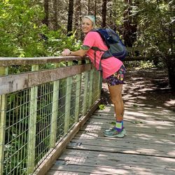
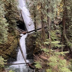
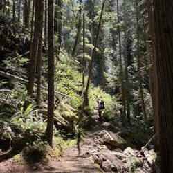
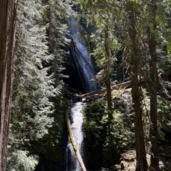
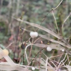
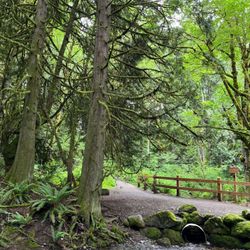
Cancel

    Open app

    Search

    Lunds Gulch

    4.0 (3 reviews)

    Lunds Gulch Photos

    You might also consider

    Recommended Reviews - Lunds Gulch

    Your trust is our priority, so businesses can't pay to alter or remove their reviews. Learn more about reviews.
    Yelp app icon
    Browse more easily on the app
    Review Feed Illustration

    15 years ago

    Helpful 1
    Thanks 0
    Love this 0
    Oh no 0
    Photo of Jan N.
    0
    11
    0

    16 years ago

    Helpful 1
    Thanks 0
    Love this 1
    Oh no 0

    16 years ago

    Helpful 0
    Thanks 0
    Love this 0
    Oh no 0

    You might also consider

    Verify this business for free

    People searched for Hiking 2,742 times last month within 15 miles of this business.

    Verify this business

    Rocky Brooks Falls

    Rocky Brooks Falls

    4.8(18 reviews)
    49.0 km

    I was staying on the peninsula for work. However, I had the later shift, so I had time to explore…read moreduring the day. Searching for waterfalls with easy access, I found Rocky Brook Falls! A few minutes drive off of 101 in Brinnon, WA you'll find Rocky Brook Falls. Across the street are a few parking spots, but beware that side is private property and there are a bunch of no trespassing signs. The entrance to the trail was not obvious to me. So I took some photos showing the path. But it's a short walk to the falls, which by the way, was a lot larger than I thought it would be! You will have to climb over some boulders to access the pool at the base of the falls, so just be aware of that. I came on a summer weekday, so there was only another couple with their dog there. You practically had the place to yourself! It has been one of the dryer summers, so I imagine after a good rainfall, the falls would be roaring and serene. Also note, there are no bathroom facilities and no cell service in the immediate area.

    What an easy hike to an unpopulated waterfall with wading, swimming, and jumping options. I don't…read morethink it gets better than this for a hidden treasure. I highly recommend. Bring some Keens or other water shoes as you have to scrabble over some larger boulders at the edge of the pool - but to keep it real, I wore flip flops. There is a dirt parking lot on left side . Cross over the road and hike the trail on the right side.

    Photos
    Rocky Brooks Falls
    Rocky Brooks Falls - Brooke Falls

    Brooke Falls

    Rocky Brooks Falls - Entrance to the trail

    See all

    Entrance to the trail

    Japanese Gulch Trails and Dog Park

    Japanese Gulch Trails and Dog Park

    4.1(17 reviews)
    10.3 km

    A diamond in the rough that we stumbled on by accident. Plan to spend more time there exploring…read morethe trails.

    These are some nice trails to roll your mountain bike on. I hopped onto the singletrack trail and…read moredang: It was a doozie within seconds. The skinny trail almost immediately points upward. In fact, there were quite a few times, where I just had to pull my feet out of the pedals & walk a little. Overall, I probably had to walk about 10 times going uphill. But---once you turn around. The roller coaster is on! I'm a bit of a fraidy cat, but I barreled down the trail pretty fast. I'm not a veteran of singletrack, so I had to really look out for roots, big rocks, holes, etc.---cuz I didn't want to eat it. So it took about 20min up this trail and about 5min down. It was a workout and hella fun downhill. There are a few ladder bridges and other types of bridges on the single track trail. If you want some serious dirt, give these trails a try. I also took the road/bigger trail which is at the very bottom of the gulch/valley. This is more of a road, and it's fairly straight and it goes up from the trailhead (paralleling the train tracks). So, there is talk of selling off this land for development. That would be a total shame Check out the website for this area and get the lowdown on this trail system's future. Hopefully Mukilteo will by this area and keep it as a cool place to hike and ride.

    Photos
    Japanese Gulch Trails and Dog Park
    Japanese Gulch Trails and Dog Park
    Japanese Gulch Trails and Dog Park - Trail sign

    See all

    Trail sign

    Murhut Falls - Murhut Falls

    Murhut Falls

    5.0(3 reviews)
    56.2 km

    One of my favorite waterfalls in Washington. Great trail and drive up to the trail. You park and…read moreturn around, and the trail is right there. I wish there was a sign because you'll get asked a lot, "Is that the trail?" To access the waterfall, if you want to get great shots of the waterfall, you have to climb down to it. We weren't able to because we have an 8-month-old. But we used to climb down to the waterfall years ago. It's a must! Our first time at this hike was 6 years ago, and we've done it a handful of times since then. I do want to say every time we have come there, there are hardly any people on the trail. Most people will scramble down by the waterfall. It's fun. You do see people turn around at the tree/bench because it's a steep climb down. But you are able to still see the waterfall. Parking: There are about maybe 10 cars that can fit, and then parking a couple of feet ahead. Restroom: None

    Such a nice hike. Very lush foliage and trees, and is a short out and back, roughly 1.6 miles. Very…read morelow elevation gain, family and dog friendly. There is some parking available right across from the trailhead. There are a lot of small fallen trees, probably due to that huge windstorm that happened a couple weeks ago. There is one tree you will have to climb over. I'm 5'0 and it was tall enough where I was almost sitting on it when I walked over it. And best of all the waterfall is spectacular! Definitely won't disappoint. I don't know how it is in the summer. There are also smaller water falls you can see on the way there.

    Photos
    Murhut Falls
    Murhut Falls
    Murhut Falls

    See all

    Lena Lake

    Lena Lake

    4.5(6 reviews)
    67.9 km

    What?! 3-stars? For...nature?…read more Yeah, I did it. If this were a hike in Indiana, or Ohio, or Kansas, it would easily be 5-stars. But, for Washington? Home to THREE National Parks, the largest glaciers in the lower 48, temperate rainforests, and hundreds of miles of coastline? Nah. This is an A-OK hike. It goes to a lake surrounded by forested hills. It looks like many lakes in WA and OR that are surrounded by forested hills. There aren't sweeping views of the Olympic Mountains, there aren't craggy cliffs overhead. There's lots of forest, and a pretty big lake. If you're super into lakes and trees, you'll dig this. But, you can find prettier lakes (Flapjack Lakes) via Staircase: https://www.yelp.com/biz/staircase-area-olympic-national-park-hoodsport And you can find prettier forests via Hoh River Trail: https://www.yelp.com/biz/hoh-rain-forest-visitor-center-forks If you're more into mountains and scenic vistas, Ellinor is much more rewarding and relatively close-by: https://www.yelp.com/biz/mount-ellinor-hoodsport SIDEBAR: this is the trailhead you climb "The Brothers" from. I can't really recommend climbing this mountain. The trail starts to fizzle out past Lena Lake and eventually becomes a full-on bushwhack. Route finding starts to take more time than actually moving. You'll second guess your every move, mutiny will be in the back of the mind for you and your comrades. The route up the mountain is also kind of winding and confusing. In early season, watch out for avalanches! One of our people got swept away by one while on this mountain, luckily she only had a sprung (It's my mission to make this word the past tense of sprang) ankle.

    This hike is perfect for an beginner-intermediate hiker. It's easy to get to & even has a paved…read moreroad up to the trailhead as opposed to the primitive roads often near trailheads. They have vault bathrooms at the beginning of the trailhead near the parking lot. I checked the bulletins and signed the registry and headed up. I instantly noticed a difference from other trails I've been on in that the majority if not all the trail is shaded so even though it was like 85+ degrees when I went, it felt much cooler and there was even a breeze at times so the heat/sun wasn't an annoyance. The trail is a general medium uphill travel. I loved that it was gradual and not just a sharp incline with a huge amount of switchbacks like other trails. It's only about 1200-1300 elevation gain total. This trail allowed me to pace myself and not stop too much to take a breath. I was able to just keep going. I also liked that the trail was wide enough in most places where 2-3 people and pass each other at one time as opposed to having to yield. I also liked that even though I went on a Saturday around 10:45am the trail was practically empty. Such a difference from the trails near Snoqualmie and North Bend. Nobody appears to want to come down toward the Hood Canal to hike. You can hear the water throughout your trek uphill so it's a relaxing hike....is that even possible? I had seen a wooden sign about a mile before the lake that said Lena Lake but what I didn't notice was the word Upper in front of Lena Lake. I actually passed the lake because I didn't see the lookout point to my right and I actually went another 1.5 miles before my intuition told me to stop. Upper Lena lake is about another 7-8 miles past Lower Lena Lake, and I was definitely not ready for that plus the hike down. I will say that the bugs get a lot worse the higher up you go, or at least they did for me. I passed two huge wasp/hornet nests and they just don't leave you alone no matter how much you swat. I also ran into some friendly grouses. No bears or mountain lions this time thankfully. Anyway, on the way back down to the lake I went off the trail a bit toward Lena Creek and there were a lot of campers and people filling up their water. You can also cross a log bridge which I believe takes you to the Brothers trail. FYI: The lake is on your right about 3.5 miles up from the trailhead. Then if you want, you can trek a mile or two down hill to get closer to the ground level of the lake as opposed to peering out over it on the rocks. My hiking app kept telling me the lake is called Olympic National Forest Pond. There were a few rowdy tubers on the lake that were disturbing the peace of the outdoors, but to each his own. Overall though, I will definitely be doing this trail again as it was the perfect length and also has the nice treat of the lake once you get to the end. Definitely take a reasonable amount of water (I took 1.5 Liters) and some food/snacks and even some swimwear. Please take your trash and doggie doo bags out with you. I did notice a few spots where there was dog feces directly on the trail or doo bags throw into the ground cover. Be a responsible dog owner please. Also as of 8/20, there were some downed logs laying across some of the Upper Lena Lake trail so you may need to crawl and climb over wet/muddy areas if you go up further.

    Photos
    Lena Lake
    Lena Lake
    Lena Lake

    See all

    Lunds Gulch - hiking - Updated May 2026

    Loading...
    Loading...
    Loading...