Cascade Falls Hiking Photos


You might also consider
More like Cascade Falls
Recommended Reviews - Cascade Falls
Start your review...

Reviews With Photos

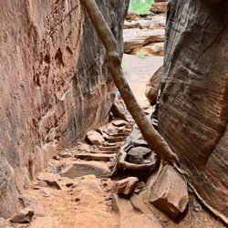
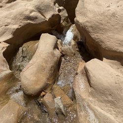
Cascade Falls is a really nice hike and is located inside of Dixie National Forrest. You don't have to be an experienced hiker to finish the trail. It's a fairly short trail but the end result is beautiful. Breathtaking vistas along the entire trail. Although the hike is only about a mile long the elevation is nearly 9,000 so it's slightly harder to breath. Be sure to not wear yourself out, and bring lots of water and inhalers if you have asthma. The trail starts in a covered wooded forrest for almost half a mile and proceeds on a rock path. There are stairs and a paved path to continue the trail. It has some spectacular views along the way, and the end result is a beautiful waterfall coming out of a cave aka Cascade Falls. I highly recommend this trail and it only takes about an hour to hike from start to finish.

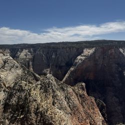
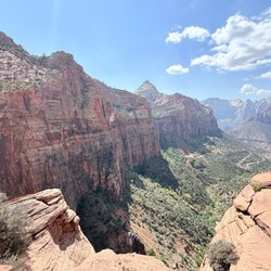
What a beautiful short easy hike located in Duck creek village in Utah. The views on this hike are so pretty and serene. It also looks across toward Zion National park. The hike will lead you along the canyon rim to a beautiful waterfall. There is a nice platform above the waterfall to take some nice scenic pictures. The hike only takes about an hour round trip. Plenty of parking at the parking lot and they also have restrooms as well. Steep drop offs along this hike so please be careful with little children. read more


3 years ago
I really enjoyed this trail. It is the perfect distance to do with kids and older members of the family. It was not too hard of a hike and very scenic. The waterfall at the end was beautiful. The trail on the weekend that we went, was a bit crowded at the end where the waterfall was but nothing too crazy. There were plenty opportunities to photos. read more


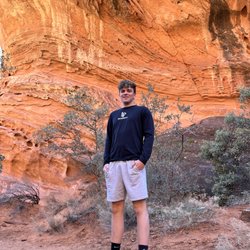
My four kids and I hiked this trail in about an hour on a Thursday late morning in late May. I am sure it can be done much faster but we don't hike for speed in our family - we like to meander and enjoy the adventure. To put everything in perspective - I am over 40, overweight, and out of shape - but based on reviews I felt fairly sure this hike was achievable. My kids are 16, 14, 13, and 11 and are all of average hiking ability for their ages. Overall - it was a little difficult for me in spots but at no point did I think I wouldn't make it there or back. I just took breaks and took my time. My kids had 0 problems at all. Some were skipping and running on the way back. The views were stunning! The waterfall was gorgeous. The path was shaded in parts and had several very cool places to sit and look (and catch your breath if you need to - ahem, cough, cough). We only saw other groups of people twice and everyone was friendly and moving along. The only thing I would say is that if you take young children, you need to be careful - one side of the trail has a steep drop off for almost the whole hike. read more


6 years ago
Cascade Falls is a really nice hike and is located inside of Dixie National Forrest. You don't have to be an experienced hiker to finish the trail. It's a fairly short trail but the end result is beautiful. Breathtaking vistas along the entire trail. Although the hike is only about a mile long the elevation is nearly 9,000 so it's slightly harder to breath. Be sure to not wear yourself out, and bring lots of water and inhalers if you have asthma. The trail starts in a covered wooded forrest for almost half a mile and proceeds on a rock path. There are stairs and a paved path to continue the trail. It has some spectacular views along the way, and the end result is a beautiful waterfall coming out of a cave aka Cascade Falls. I highly recommend this trail and it only takes about an hour to hike from start to finish. read more


6 years ago
This was a great hike to take my little one on... its fairly short, not too strenuous, and the views are amazing! Highly recommend for beginner hikers. read more


7 years ago
13 years ago
12 years ago
8 years ago
6 years ago
More info about Cascade Falls
Dixie National Forest
Duck Creek Village, UT 84762
Directions
Hours
Outdoor Amenities
Ask the Community - Cascade Falls
Review Highlights - Cascade Falls
You might also consider


Cascade Falls - hiking - Updated May 2026
Best of Duck Creek Village
People found Cascade Falls by searching for…
Lakes in Duck Creek Village, UT
Things to Do in Duck Creek Village, UT
Hiking Trails With Waterfalls in Duck Creek Village, UT
Scenic Drive in Duck Creek Village, UT
Parks in Duck Creek Village, UT
Sunset View in Duck Creek Village, UT
Visitor Centers in Duck Creek Village, UT
Canyoneering in Duck Creek Village, UT
Hiking With Kids in Duck Creek Village, UT
Walking Trails in Duck Creek Village, UT
Lookout Points in Duck Creek Village, UT
Scenic Night View in Duck Creek Village, UT
Parks for Kids in Duck Creek Village, UT
Off Road Trails in Duck Creek Village, UT
Running Trails in Duck Creek Village, UT
Easy Hikes in Duck Creek Village, UT
Things to Do on a Rainy Day in Duck Creek Village, UT
Photo Spots in Duck Creek Village, UT
Scenic Overlook in Duck Creek Village, UT
Hikes With Dogs in Duck Creek Village, UT
Waterfalls in Duck Creek Village, UT
Hiking Trails Kid Friendly in Duck Creek Village, UT