Cahuilla Mountain Trail Photos


 on Tripp Flats rd.. - Hiking Near Me - Anza, California")

You might also consider
More like Cahuilla Mountain Trail
Recommended Reviews - Cahuilla Mountain Trail
Start your review...

7 months ago
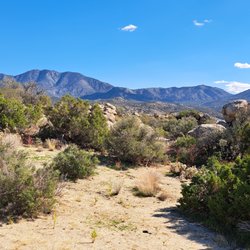
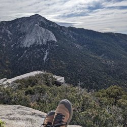
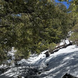
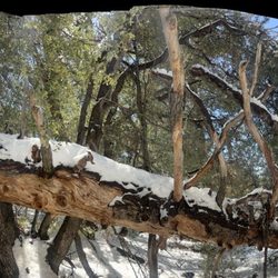
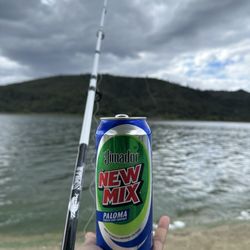
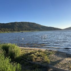
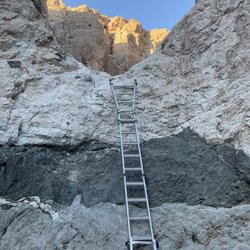
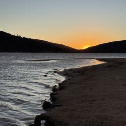
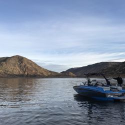
Excellent maintained trail at the trailhead, there is a rough 2 mile drive to get to the trailhead I would suggest a high clearance vehicle or four-wheel-drive. Stunning views of three different lakes and surrounding mountains and valleys from the summit. Well worth the hike approximately 7 miles out and back with a 1350 foot elevation gain read more


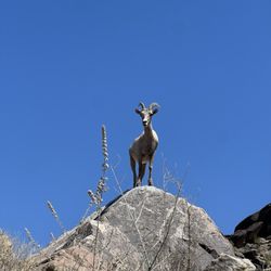
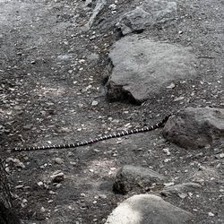
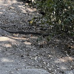
Use my directions to locate the correct dirt road to turn off on. Your GPS might lead you down the wrong roads ( which happened to us). I was looking for a hike that didn't require a wilderness hiking permit and found the Cahuilla Mountain Trail. The hike is 2.5 miles each way, but it seems longer because of the heat and the elevation gain. There are several different eco-zones here from chaparral to high desert to pines. Many cool rocks along the way. Some portions of the trail are overgrown and tight. Directions - Take Hwy 371 till you reach Cary road. Go 3.7 miles, the road eventually turns into Tripp Flats road. Look for the sign on the left hand side of the road indicating the trail road ( I took a picture of it ). From the turn off to the small dirt parking lot is about 2 miles up a small winding dirt road. Don't worry, you don't need a 4x4. The trick is to look for something that looks big enough to park a few cars. What tricked me was there wasn't a trail head sign ( though another review I read said to look for it ). Apparently there was a fire and the sign is gone now. So park in this dirt lot and look to the south. You should see an entrance with a metal gate. BTW, If you pass the parking lot by accident and hit to a fork in the road you'll need to turn back, you've gone too far.. - Several rattlesnakes on the trail.. read more


More info about Cahuilla Mountain Trail
You might also consider


Cahuilla Mountain Trail - hiking - Updated July 2026
Best of Anza
People found Cahuilla Mountain Trail by searching for…
Things to Do in Anza, California
Hiking Trails in Anza, California
Redwood Trees in Anza, California
Waterfall Hike in Anza, California
Lakes & Ponds in Anza, California
Canyoneering in Anza, California
Swimming Holes in Anza, California
Tourist Attractions in Anza, California
Off Road Trails in Anza, California
Dog Friendly Trails in Anza, California
Free Campgrounds in Anza, California
Fun Places to Go in Anza, California
Stroller Walk in Anza, California
Stairs Workout in Anza, California
Flower Field in Anza, California
Things to See in Anza, California
Secluded Spots in Anza, California
Places to Take Pictures in Anza, California
Scenic Overlook in Anza, California
Trending Searches in Anza, CA
4th Of July Fireworks near Cahuilla Mountain Trail
Black Owned Nail Salons near Cahuilla Mountain Trail
Boat Rental near Cahuilla Mountain Trail
Cliff Jumping near Cahuilla Mountain Trail
Day Trips near Cahuilla Mountain Trail
Fireworks near Cahuilla Mountain Trail
Jet Ski Rental near Cahuilla Mountain Trail
Kayak Rental near Cahuilla Mountain Trail
Lakes & Ponds near Cahuilla Mountain Trail
Off Road Trails near Cahuilla Mountain Trail
Outdoor Activities near Cahuilla Mountain Trail
Places To Walk Around near Cahuilla Mountain Trail
Public Pools near Cahuilla Mountain Trail
Public Shower near Cahuilla Mountain Trail
River Swimming near Cahuilla Mountain Trail
Rock Quarry near Cahuilla Mountain Trail
Running Trails near Cahuilla Mountain Trail
Scenic Night View near Cahuilla Mountain Trail
Scenic Overlook near Cahuilla Mountain Trail
Secluded Spots near Cahuilla Mountain Trail
Soccer Store near Cahuilla Mountain Trail
Splash Pad near Cahuilla Mountain Trail
Strawberry Picking near Cahuilla Mountain Trail
Sunrise View near Cahuilla Mountain Trail
Swimming Holes near Cahuilla Mountain Trail
Swimming Lakes near Cahuilla Mountain Trail
Watch Sunset near Cahuilla Mountain Trail
Browse Brands
Related Searches in Anza, CA
Best Fishing Locations and Guides in Anza, California
Best Nature Trails for Hiking in Anza, California
Best Places for Horseback Riding in Anza, California
Best Sledding Spots and Fun in Anza, California
Best Waterfalls and Swimming Holes in Anza, California
Check Out Off Road Trails in Anza, California
Discover Dog Friendly Trails to Explore in Anza, California
Discover Kid Friendly Hiking Trails in Anza, California
Discover Scenic Waterfall Spots in Anza, California
Discover Walking Parks in Anza, California Near You
Discover a Hiking Trail in Anza, California
Discover the Best Night Hike Trails in Anza, California
Dog-Friendly Hikes With Dogs in Anza, California
Enjoy Camping Adventures Around Anza, California
Enjoy Exciting Mountain Biking Adventures in Anza, California
Enjoy Kayaking Adventures in Anza, California
Enjoy Tent Camping Spots Around Anza, California
Enjoy a Beautiful Waterfall Hike in Anza, California
Enjoy the Best Picnic Spots and Ideas in Anza, California
Enjoy the Best Walking Trails in Anza, California
Exciting Cliff Jumping Spots in Anza, California
Explore Beautiful Parks and Green Spaces in Anza, California
Explore Easy Hikes Perfect for All in Anza, California
Explore Fun Activities to Do in Anza, California
Explore Popular Campgrounds Near Anza, California
Explore Top Dog Parks in Anza, California Near You
Explore the Best Beach Spots in Anza, California
Explore the Best Boating Spots in Anza, California
Explore the Best Swimming Holes Around Anza, California
Explore the Best Trail Options in Anza, California
Family Friendly Hiking With Kids in Anza, California
Find Beautiful Views in Anza, California
Find the Best Parks for Picnics in Anza, California
Find the Best Playgrounds to Visit in Anza, California
Great Places to Walk in Anza, California
Hike the Popular Waterfall Trail in Anza, California
Hiking Trails With Waterfalls in Anza, California
Off Leash Dog Hiking Trails in Anza, California
Plan a Scenic Drive Route Near Anza, California
Popular Outdoor Activities to Try in Anza, California
Popular Picnic Spots to Visit in Anza, California
Popular Things to See in Anza, California
Safe and Fun Parks for Kids in Anza, California
Top Climbing Spots and Gyms in Anza, California
Top Playgrounds for Kids to Enjoy in Anza, California
Top Running Trails to Explore in Anza, California
Top Swimming Lakes to Enjoy in Anza, California
Top Swimming Spots and Pools in Anza, California
Browse Articles
People who viewed Cahuilla Mountain Trail also viewed
San Jacinto Via Marion Mountain
21 reviews
Clayton A Record Jr Viewpoint
1 review
South Ridge Trail
5 reviews
Tahquitz Peak via Devil's Slide Trail
22 reviews
Santa Rosa and San Jacinto Mtns Nat'l Monument Visitors Center
21 reviews
Deer Springs Trail To Suicide Rock
27 reviews
Araby Trail
13 reviews
Indian Vista
3 reviews
Massacre Canyon
8 reviews
San Jacinto Ranger Station
18 reviews