
Adventures In Seattle Photos


You might also consider
More like Adventures In Seattle
Recommended Reviews - Adventures In Seattle
Start your review...

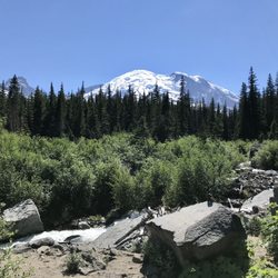
Shoutout to Sophia and our guide Matthew for a great hiking trip! I visited Seattle with the guys and we wanted to take advantage of the city's easy access to scenic landscapes. Adventures In Seattle (AIS) seemed like the best option for a hiking tour. They were fairly priced, provided gear/food/transport, and were led by experienced local guides. That's right! No need for a rental car. They pick you up right from your hotel/Airbnb and also drop you back off. Furthermore, AIS equipped us with technical backpacks, hiking poles, lunch, snacks, and extra water. Our experience was not without challenges. Mainly, we were forced to change plans 1.5 weeks out and pivot away from our 1st choice hike due to poor road conditions. Sophia presented us with some alternative hikes and let us decide. Moreover, we were allowed to tailor the hike somewhat to meet our needs. I was receiving all of my information 2nd hand, so I decided to call up Sophia myself. She was incredibly helpful explaining the situation, answered all of my questions regarding our alternatives as well the services they provided, and offered recommendations/tips to prepare for the hike. Matthew was also a pleasure to work with! He arrived at our AirBnb at our predetermined time (he was actually a tad early, but I will happily take that over tardiness). Matthew drove us from Seattle to a small town for food/rest, and then to Mt. Rainier National Park. When we arrived, he made sure we were all prepared to our hike. Matthew was great at explaining all of the sights and let us take enough rest breaks on our way up. He was an excellent guide. If you're looking for a hiking tour in the area, Adventures In Seattle is a great choice! I highly recommend them and will consider booking another tour next time I'm in Seattle. read more
Sophia is fabulous!!! My friend and I were looking to do an one day outdoor activity not too far away from Seattle and we contacted Sophia based on the review on Yelp and Trip Advisor. We decided to do a day hike to Gold Myer Hot Springs and it was fantastic! Sophia picked us up at 8:30am in the South Lake Union, she had everything ready for us such as lunch and equipment. It wasn't a long drive out of Seattle, we just wasn't lucky with the weather as it was raining the whole day. I was so relieved when she told me she has an extra pair of waterproof pants I can borrow, cuz I was wearing a pair of jeans which would make me miserable walking in the rain. The hike itself was a 6 mile easy hike (one way), mostly flat, even though it was raining, the scenery was gorgeous! At the end of the hike, we arrived at the natural hot springs, we were really lucky that the whole hot springs were for ourselves and we spent quite a bit of time there recharging energy! After hiking another 6 mile back to the car, Sophia drove us back to SLU, the whole trip was hassle free and Sophia was such a great guide, she was so friendly and interesting to talk to, always checking how we are feeling to make sure that we are not too cold or tired. We really enjoyed the day out and will definitely do other activities with Sophia again, highly recommended!!! read more


9 years ago
9 years ago
9 years ago
8 years ago
9 years ago
More info about Adventures In Seattle
8120 256th Ave E
Buckley, WA 98321
Directions
(253) 508-9441
Call Now
Visit Website
http://www.adventuresinseattle.com
Hours
Outdoor Amenities
Other Amenities
From the Business
Ask the Community - Adventures In Seattle
You might also consider


Why does Yelp recommend reviews?
Adventures In Seattle - hiking - Updated July 2026
Best of Buckley
People found Adventures In Seattle by searching for…
Trending Searches in Buckley, WA
Black Owned Nail Salons near Adventures In Seattle
Boat Rental near Adventures In Seattle
Cliff Jumping near Adventures In Seattle
Day Trips near Adventures In Seattle
Jet Ski Rental near Adventures In Seattle
Kayak Rental near Adventures In Seattle
Lakes & Ponds near Adventures In Seattle
Off Road Trails near Adventures In Seattle
Outdoor Activities near Adventures In Seattle
Picnic Spots near Adventures In Seattle
Places To Swim near Adventures In Seattle
Places To Walk Around near Adventures In Seattle
Pool Day Pass near Adventures In Seattle
Public Pools near Adventures In Seattle
Public Shower near Adventures In Seattle
River Swimming near Adventures In Seattle
River Tubing near Adventures In Seattle
Rock Quarry near Adventures In Seattle
Running Trails near Adventures In Seattle
Scenic Night View near Adventures In Seattle
Scenic Overlook near Adventures In Seattle
Soccer Store near Adventures In Seattle
Splash Pad near Adventures In Seattle
Sunrise View near Adventures In Seattle
Swimming Holes near Adventures In Seattle
Swimming Lakes near Adventures In Seattle
Watch Sunset near Adventures In Seattle
Browse Articles
Browse Nearby
BEST of Buckley, Washington Restaurants near Adventures In Seattle
BEST of Buckley, Washington Coffee near Adventures In Seattle
BEST of Buckley, Washington Breakfast near Adventures In Seattle
BEST of Buckley, Washington Things to Do near Adventures In Seattle
BEST of Buckley, Washington Campgrounds near Adventures In Seattle
BEST of Buckley, Washington Thrift Stores near Adventures In Seattle
Browse Brands
Related Searches in Buckley, WA
Affordable Kayak Rental Services in Buckley, Washington
Best Fishing Locations and Guides in Buckley, Washington
Best Places for Horseback Riding in Buckley, Washington
Best Sledding Spots and Fun in Buckley, Washington
Best Waterfalls and Swimming Holes in Buckley, Washington
Check Out Off Road Trails in Buckley, Washington
Discover Dog Friendly Trails to Explore in Buckley, Washington
Discover Scenic Mountain Bike Trails Near Buckley, Washington
Discover Scenic Waterfall Spots in Buckley, Washington
Discover Top Nature Parks to Visit in Buckley, Washington
Discover a Hiking Trail in Buckley, Washington
Discover the Best Night Hike Trails in Buckley, Washington
Enjoy Exciting Mountain Biking Adventures in Buckley, Washington
Enjoy Kayaking Adventures in Buckley, Washington
Enjoy a Beautiful Waterfall Hike in Buckley, Washington
Enjoy the Best Walking Trails in Buckley, Washington
Exciting Cliff Jumping Spots in Buckley, Washington
Experience Thrilling White Water Rafting in Buckley, Washington
Explore Beautiful Parks and Green Spaces in Buckley, Washington
Explore Easy Hikes Perfect for All in Buckley, Washington
Explore Fun Activities to Do in Buckley, Washington
Explore Popular Campgrounds Near Buckley, Washington
Explore Popular Scenic Overlook Points in Buckley, Washington
Explore Scenic Lakes to Visit in Buckley, Washington
Explore the Best Beach Spots in Buckley, Washington
Explore the Best Swimming Holes Around Buckley, Washington
Explore the Best Trail Options in Buckley, Washington
Family Friendly Hiking With Kids in Buckley, Washington
Find Beautiful Views in Buckley, Washington
Find Fun Kids Activities Outdoor in Buckley, Washington
Find Popular Ziplining Spots Around Buckley, Washington
Find the Best Parks for Picnics in Buckley, Washington
Find the Best Playgrounds to Visit in Buckley, Washington
Find the Best Scenic View Locations in Buckley, Washington
Great Places to Walk in Buckley, Washington
Hiking Trails With Waterfalls in Buckley, Washington
Off Leash Dog Hiking Trails in Buckley, Washington
Plan a Scenic Drive Route Near Buckley, Washington
Popular Fishing Spots to Explore in Buckley, Washington
Popular Outdoor Activities to Try in Buckley, Washington
Popular Picnic Spots to Visit in Buckley, Washington
Popular Things to See in Buckley, Washington
Safe River Swimming Areas in Buckley, Washington
Safe and Fun Parks for Kids in Buckley, Washington
Top Playgrounds for Kids to Enjoy in Buckley, Washington
Top Running Trails to Explore in Buckley, Washington
Top Swimming Lakes to Enjoy in Buckley, Washington
Top Swimming Spots and Pools in Buckley, Washington
People who viewed Adventures In Seattle also viewed
Melmont Ghost Town
4 reviews
Grandview Chambers Bay Bike and Hike Trail
33 reviews
Rhododendron Garden
5 reviews
Federation Forest State Park
1 review
Glacier Basin Trail
2 reviews
Dumas Bay Sanctuary
8 reviews
McCormick Forest Park
7 reviews
Nathan Chapman Memorial Trail
12 reviews
Puyallup Trail
3 reviews
Green River Community College Fitness Trail
4 reviews