Cancel

    Open app

    Search

    Silver Falls

    4.5 (12 reviews)

    Silver Falls Photos

    You might also consider

    Recommended Reviews - Silver Falls

    Your trust is our priority, so businesses can't pay to alter or remove their reviews. Learn more about reviews.
    Yelp app icon
    Browse more easily on the app
    Review Feed Illustration

    Reviews With Photos

    Jewel-colored water
    Dawn G.

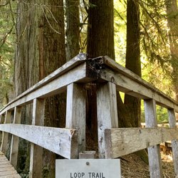
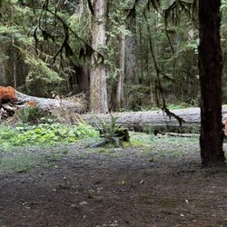
    We hiked the Silver Falls Loop trail in August and really enjoyed it. To get to the trailhead we entered the Ohanapecosh Campground area. There is a building with restrooms and a park ranger to answer questions. We quickly found parking in a small section by the campgrounds. A National Park Pass or America The Beautiful Pass is required. The trail itself is well-marked and easy to follow. Approximately 3 miles round trip with only about 600 feet of elevation gain, making it ideal for new hikers or those who don't want a strenuous workout. The trail is full of a variety of foliage and pretty moss-covered trees. When we reached the waterfalls it was breathtaking. The jewel colors in the river were gorgeous and the sounds of the falls were so relaxing. It's the type of location where you want to stay awhile and enjoy the sights and sounds while reading a book and eating lunch. Highly recommend a visit.

    Loved the shades of green
    Elisabeth P.

    We enjoyed this hike on a perfectly rainy PNW day. Luckily, the forest canopy helps to shield you from the raindrops and the little drizzle really didn't deter us at all. There is a good sized parking lot with reasonably nice bathroom facilities and picnic tables for lunching. It's a very easy 4 mile loop trail with a mild 705 foot elevation gain that was very gradual. The trail is really well maintained and features views of the Ohanapecosh River throughout the hike. The falls themselves are gorgeous and you can get up close and personal with them at the top. There are nice spots for sitting and enjoying the mists. After the falls cascade into the pool below it then transfers into a beautifully deep green river that cuts through the forest. The rest of the hike is also enjoyable with a well maintained trail and a canvas of different shades of green. At the end we settled at the picnic tables for a little snack before our drive back home. Very nice little hike for a variety of hiking levels.

    Rob Y.

    Easy hike. Took just under an hour for round trip and stopping for pictures. Trailhead was immediately across the road from the toilets at the Grove of the Patriarchs trailhead... easy to find using the map that the ranger handed me on entry to the park. We turned around at the bridge that offered beautiful viewpoints.

    Josh B.

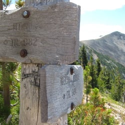
    My friend is on a hiking kick to see hikes with waterfalls, so she decided that we would go to Silver Falls. We kind of made the mistake of coming in the Nisqually entrance and had to drive about 15 miles to the Stevens Canyon Entrance on the other side of the park which can make for some slow driving since the roads are windy. Anyway, once we got to the Patriarch parking lot, the hike can by 2-3 miles round trip. You can park at the Grove of the Patriarchs lot and cross the street at the sign that says Eastside Trail and follow the trail south toward Silver Falls. There are small signs along the way that guide you to the falls so keep your eyes peeled. There are several smaller falls along the way and several spots where people were able to take a cooling dip in the pools of water captured in the rocky slope. I don't know if swimming is sanctioned by the park, but enter at your own risk as there is still rushing water nearby and cliffs where death is probably imminent. I would say keep an eye on your kids as well as several areas lead directly to the water's edge with no barrier and the rocks can be slippery. The trail is very easy though and perfect for kids, but no strollers though. The other way to get to the falls is to park at the Ohanapecosh Visitors center and follow the trail labelled Silver Falls Loop Trail going north toward the falls. I believe Silver Falls is only accessible by the routes I've mentioned in the summer months as parts of Hwy 123, the Ohanapecosh visitors center , & the Stevens Canyon entrance are closed during the winter. You can always check with the park rangers for directions. With that said, the falls can still be reached in the winter by taking the Eastside Trail off of Stevens Canyon Rd at the Grove of the Patriarchs lot. This hike was a lot of fun and almost completely shaded and moderately manicured so it was nice to just hang out by the rushing sounds of the falls and take in the breeze with a few good friends. I'd say maybe one bottle of water would suffice and maybe some bug spray and some decent shoes. It's not a strenuous trail and is a very beginner trail.

    Vladmir T.

    Massively Powerful Water Flow! Only a short hike from the road or about 2.2 miles from the campground. Great nature to be seen; amazing greenery and great trails to travel on. The falls are majestic and powerful for sure. The water is so forceful and volumous that the ground shakes a bit! I imagine the water is less forceful as more of the snow melts later in the year, but in June it was impressive! I wouldn't want to fall into that water or down the fall! All in all Its a great little spot that you shouldn't miss if in the area.

    Silver Falls near Mount Rainier
    Chris H.

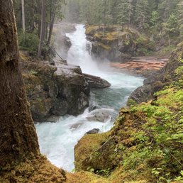
    Silver Falls is a series of short, cascading falls and gorgeous deep cuts through bedrock in the Ohanapecosh River, southeast of Mount Rainier and just inside the entrance to the Park. It's easily accessible via the Silver Falls loop trail, which is roughly 4.5 miles; it runs from the main parking area and trail head just inside the Park to Ohanapecosh Campground and back on either side of the river. The lowest falls have carved out a lovely plunge pool with several good vantage points for viewing...although I was there in the fall, there was still a lot of water going through but it was low enough that we could see and appreciate all of the twists and turns in the channel around the falls. Also, the water was gorgeously clear this late in the season, and the deeper channels in the river ran a beautiful deep turquoise color. Photo opportunities abound, as do riverside resting/picnicking spots. The trail is very well maintained; the hike was pretty easy even for a sluggard like myself but the terrain definitely rolls up and down a fair amount. We saw a few couch potatoes who were struggling a bit. Highlights (aside from the river and the falls) included lots of heavy stands of trees and ferns, wildflowers, a lovely stand of tall grass near a hot springs and occasional bird life...we got to watch a woodpecker do its thing on a dead tree for a good long while. The hot springs is certainly not big enough to luxuriate in, unless you're the size of, say, a G.I. Joe. Final thought: this hike is a great and welcome contrast to the adjacent trail that goes to Grove of the Patriarchs, the stand of 1000-year old firs and cedars. That trail is packed with people and is more or less a short walk along a wide, flat boardwalk with a few stairs and a bridge; hence, it has hundreds of people on it. The Silver Falls trail has 1% as many people, thanks to its slightly higher degree of difficulty and its less-dramatic name ("Grove of the Patriarchs" reminds me of "Clash of the Titans").
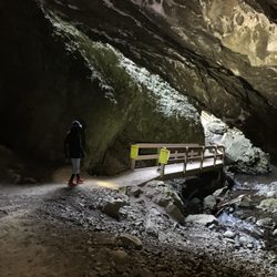
    See all

    9 months ago

    Helpful 0
    Thanks 0
    Love this 0
    Oh no 0

    2 years ago

    Helpful 1
    Thanks 0
    Love this 0
    Oh no 0
    Photo of Kim R.
    180
    1107
    3098

    5 years ago

    Helpful 6
    Thanks 0
    Love this 3
    Oh no 0
    Photo of Dawn G.
    727
    431
    5164

    6 years ago

    Helpful 7
    Thanks 0
    Love this 4
    Oh no 0

    6 years ago

    Helpful 3
    Thanks 0
    Love this 3
    Oh no 0
    Photo of Rob Y.
    0
    20
    4

    5 years ago

    Helpful 2
    Thanks 0
    Love this 1
    Oh no 0
    Photo of Josh B.
    347
    1174
    9128

    11 years ago

    Helpful 3
    Thanks 0
    Love this 4
    Oh no 0
    Photo of Vladmir T.
    1771
    1656
    5085

    9 years ago

    Helpful 4
    Thanks 0
    Love this 6
    Oh no 0

    10 years ago

    Helpful 15
    Thanks 0
    Love this 14
    Oh no 0

    5 years ago

    Helpful 0
    Thanks 0
    Love this 1
    Oh no 0
    Photo of Pamela T.
    58
    50
    209

    10 years ago

    Helpful 1
    Thanks 0
    Love this 0
    Oh no 0

    8 years ago

    Helpful 1
    Thanks 0
    Love this 0
    Oh no 0

    Ask the Community - Silver Falls

    Review Highlights - Silver Falls

    The trail is really well maintained and features views of the Ohanapecosh River throughout the hike.

    Mentioned in 2 reviews

    Read more highlights

    Verify this business for free

    Get access to customer & competitor insights.

    Verify this business

    Grove of the Patriarchs - Grove of the Patriarchs is a round trip loop. You can start in either direction.

    Grove of the Patriarchs

    (6 reviews)

    If you're a tree enthusiast such as myself, you will probably have the Patriarchs on your list of…read morestops while visiting Rainier. We couldn't get to it when visiting, as the road over from the SW entrance was closed already. So we actually went out and around to the SE entrance to take in the Grove and Silver Falls...worth it. Not far past the entrance you'll come to the Grove parking lot, restrooms included. I didn't have much time, so I went at quite a clip down the path, and a pretty cool path it was. You get to walk under the canopy of the beautiful forest along the river for a while...then you come to a verrrry wobbly suspension bridge to cross the river and enter the realm of the Patriarchs. It was pretty muddy when I was there, so I had to bob and weave from the bridge until I reached the boardwalk. From there you just let the boardwalk lead you as you wind through the Patriarchs, with lots of signs along the way to educate you as you take them in. A beautiful and short hike...I'm glad I went out of the way to see the big guys in person.

    Eh, well, Grove of the Patriarchs was my least favorite activity while exploring Mount Rainier…read moreNational Park. I figured walking around and being surrounded by majestically tall trees would be worthwhile, but for me...this area fell flat. But...it could just be the fact that I have visited Sequoia and Kings Canyon National Parks featuring some of the tallest trees in the world over there in California even including Redwood National Park and some statuesque trees there also. I guess what I'm trying to say is that this Grove of the Patriarchs didn't impress me so much. Some details I'd like to mention about Grove of the Patriarchs for those tourists possibly considering this a spot to include within Mount Rainier... - It's a very simple 1.5 mile round trip walk with zero elevation gain. So...it'll basically take you no time to explore and browse through the forest. Maybe I needed an hour while I was there. - It's just fine for families as you walk along a boardwalk throughout. - The trailhead is located right in between the two main sections and most popular areas of Mount Rainier. It sits about 35 miles from the Paradise section and about 35 miles from the Sunrise section. That's why I figured this trail could be worthwhile as it'd give me an opportunity to break up the drive between Paradise and Sunrise. And for those who care...I explored all of Paradise, came here to Grove of the Patriarchs in early morning and then continued onto Sunrise. One thing...when I came here in early morning, the sun was yet to fully rise and there were plenty of dark shadows and overall a dim atmosphere which made my photography not the greatest. I believe you'd be better served to come here (if you choose to) in midday. Another disappointing aspect about this Grove of the Patriarchs is that it's very hidden along the road. Granted it's a simple roadside stop, but there was no sign stating "Grove of the Patriarchs"! I ended up passing it by while driving and had to ask a Park Ranger at an entrance station where the trailhead was. I ultimately I had to turn around and backtrack. Now...the real sign for Grove of the Patriarchs from the road will say....Eastside Trail! Yes this Eastside Trail is the alter name for Grove of the Patriarchs. Keep that in mind as I have no clue why it's called Eastside Trail. Only makes it confusing for tourists. While getting started on the Grove of the Patriarchs Trail you'll first encounter a small suspension bridge which adds a little fun element to the trek as you enter the heart of the forest. Also along the way there'll be a posted sign describing the trail including a small map of the path. After crossing over the suspension bridge, there'll be a sign saying Loop Trail. Since the boardwalk circles around in a loop...you can head in either direction left or right. It makes no difference. In the end you'll finish where you started. Finally, my biggest issue was just the Patriarchs or giant trees or whatever you may call them...they weren't so impressive to me. I wanted to give the benefit of the doubt that this trail would be scenic enough and special for me. But unfortunately I left unfulfilled after completing the 1.5 miles. I believe my real issue or key to being here at Mount Rainier is of course....Mount Rainier itself. Obviously it's the focal point for everything you do. The second most exciting part about Mount Rainier are the waterfalls. There's some incredible, and I mean incredible hikes and roadside stops to witness some of the best waterfalls around, including my favorite...Comet Falls! Yes Comet Falls was unlike anything I had seen until I encountered Multnomah Falls on the Oregon/Washington border, lol. But here at Grove of the Patriarchs I figured having a chance to walk around some massive trees would add a different element to my Mount Rainier experience. Getting to immerse myself in a unique setting and terrain sounded pretty amazing. But I never truly connected to it overall. Still...with all the incredible hiking opportunities at the Paradise and Sunrise sections of Mount Rainier...you can't go wrong with almost anything you do at this Top 10 national park (in my opinion). Of course...how typical is it that here I am writing about my least impressive attraction during my 4 day visit. It's okay I just wanted to give anyone out there a suggestion that if you come here to Grove of the Patriarchs Trail...maybe just temper your expectations.

    Shoe Lake Hike Via Pacific Crest Trail - Old Snowy

    Shoe Lake Hike Via Pacific Crest Trail

    (1 review)

    Had been stalking the White Pass/Shoe Lake area for windows of good weather the last month or two…read more(every weekend, it would conveniently be rainy/snowy up there!). Recently I saw the forecast open up for some sunny conditions---during the work week. I decided to make the trip---isn't that what vacation days are for?? I drove up to White Pass, from the east side, with clear blue skies the entire way. I parked on the highway (across from the Kracker Barrel at the base of the White Pass slopes). I slapped on my 35lb pack, grabbed my dogs, and we scrambled up the slopes. I like going this route (vs. starting at the Trailhead) because there are nice views and it cuts down on distance. It's a bear of a workout though! Once on the PCT, it's a nice, fairly flat, and scenic hike---y'know, the usual. Near the new ski run up on top, I heard/saw workers cutting/burning trees to clear way for the ski run (sometimes I wish I could make them turn the ski lift ON, so I could be taken all the way up to the Miriam Lake Basin....but what fun would that be?? I had seen evidence of recent snow every here and there (1-4" patches of snow). Once at the Miriam Lake Basin/Hogback Ridge, I made my way to Shoe Lake. There's one stretch of this big open piece of trail where there was quite a bit of hard icy snow. Camped above the beautiful Shoe Lake. I heard an elk bugling at around 7pm---it must have been south down the hill. Such a cool sound to hear! But it was also scary, because within seconds I also heard something very big plodding around nearby--definitely an elk. It was so close I could hear it breathing. A wee bit scary! (and cool) Oh, I did spy some huckleberries along the way, amazingly enough---but they weren't as good as the ones I picked 3weeks ago. Such a late season! The night yielded beautiful views of the Milky Way, constellations, Jupiter, satellites, and the like. The hike back was nice for most of the way. I saw a herd of mountain goats in the Miriam Lake Basin. The snow/ice mentioned earlier was pretty scary in the morning. The first clouds of the trip rolled in around 1pm...but I was pretty much done. While unloading at my car, an employee from the Kracker Barrel rode his bike to me. He was wondering where I was and if I was ok. Apparently, I forgot to roll my driver's side window up---so it was open for 24hrs!! Everything was fine, but I sure felt dumb. Anyway, probably my last backpacking trip of 2011. A great way to end the season!

    Tipsoo Lake

    Tipsoo Lake

    (9 reviews)

    This lake has an amazing view of Mount Rainier if you are not looking to go directly to the…read moremountain. We came during the end of July (around 4PM) which is the best time to see all the beautiful wildflowers. It was really hot and there's so many bugs but this area is such a pretty place to take photos. We did leave with at least five mosquito bites so make sure to come prepared with bug spray and sunscreen! This is also right across from Naches Loop Trailhead and has parking as well; can only get down to the lake by staircase so this may be a struggle for those who are disabled. The view of the mountain is so pretty and totally worth it to stop by. The trail is also not hard so very kid friendly!

    Tipsoo Lake is a beautiful location full of wildflowers, evergreens, various hiking trails, and a…read moregorgeous view of Mount Rainier on a clear day. The day we went it was really foggy outside early in the day and it was just starting to clear when we were ready to leave. But check out those Rainier photos from other hikers who were fortunate to have visited on a bright day. Spectacular! Tipsoo Lake is quite small and has a walking path around it that is flat and easy to walk for hikers of all abilities. Along that path you can find a variety of flowers (including those cool Lorax kind) as well as paths leading to other trails such as Naches Peak Loop. If you head up that trail a bit from the lake, you'll come to a bridge that goes over highway 410 and that can be a nice viewing point for kids. There are a small number of parking spaces (10 to 12) in a tiny lot right off of the freeway and you may be fortunate enough to snag a spot if you arrive early. Friendly reminder to mind the signs and stay on the trail to protect the surrounding land and flowers.

    Reflection Lakes Loop Hike - Great reflection of mt Reinier

    Reflection Lakes Loop Hike

    (9 reviews)

    This is a great hike for photographers if you want to get both a nice view of Mount Rainier and of…read moreits reflection in the lake. The best time to come here is on a clear day and when the water is calm. You get stunning views of the alpine lakes and of the mountain peaks in the background. I made two stops here during my trip because the wind had caused ripples on the water and I wasn't able to get a clear shot with my camera. The reflection was much more clearer the second stop. Reflection Lakes is located off of Stevens Canyon Road just south of Paradise in Mount Rainier National Park. After parking, head down to the lake to find the hiking trail. The parking lot can fill up during the busier part of the day. The Lakes Trail is a three mile loop trail that goes around the lake and starts from either end of the parking lot. Wildflowers border the lakes in summer which adds some nice color to your photographs. The park asks that you stay on the trail to protect the meadow around the lake. Pinnacle Peak Trail is another popular trail that starts south of the Reflection Lakes parking lot. I really enjoyed making a stop here. It is one of the best places to get an iconic picture of Mount Rainier. There is no swimming, fishing, or boating in Reflection Lakes. But nearby Louise Lake allows wading and fishing. You can only visit Reflection Lakes in the summer as Stevens Canyon Road closes up during the winter season.

    Made a quick stop here to see the reflection of Mt Rainier…read more Heard it's supposed to be beautiful at sunrise, but it was rainy during our visit so we forewent the early morning visit. Came around 9am-ish on a cloudy day and were able to see a decent reflection - can only imagine how beautiful it would be on a nice, sunny day. We did a bit of the walk around the lakes, and while the walk was nice, the best views come from the overlooks where you park. Definitely worth a quick stop while driving by. If the weather is good, consider sunrise - you might be in for a wonderful surprise.

    Mount Aix Trail - survey marker at aix peak

    Mount Aix Trail

    (1 review)

    Went on first real cascade hike of the summer. Would have loved to do an overnighter, but decided…read moreto make it a day hike. Knew this would be a big slap in the face with a round trip distance of 12 miles and 4000-ft of elevation change, but it was such a nice day, and it WAS my first real hike of the summer. Left the Tri-Cities around 7:30 and basically left the Aix trailhead around 10:00. Before heading up, we were greeted by a Ranger. She was swarmed by my two dogs. She just wanted to remind us that there are no camp fires and that the fire hazard was very high. She was really nice, and we ended up picking her brain about the hike (I hadn't done it in many years). She said it shouldn't be bad and there would be fifteen switchbacks we'd have to contend with, sounding like she was trying to scare us. I was a little scared. We hit the trail--my two short-legged corgis and a couple of co-worker friends. Conditions were great. Wasn't too cold or too hot (although I always sweat even if its -30!). Within the first 10 minutes we hit our first switchback, and another, and another.... Honestly, we hit 15 switchbacks within the first 30min or so--easily. Man! Ranger Lady, why are you messing w/ our heads?! For much of the first hour you walk through a forested area, and cross a few springs /creeks. It was somewhat ho-hum. But within the first hour or so, you start getting little windows between the trees which yield views of "the big one", Mt Rainier. As I said the weather was awesome, and the visibility was infinite. We had great views of Rainier. Kept on hiking and the higher and higher we got the trees started thinning out. This yielded open meadows which were blanketed with light purples, yellows, oranges, and bright reds---wild flowers were doing their thing. The approach to treeline and the opening up of the scenery is when the hike became really interesting. Reached Nelson Ridge around noon-ish (hike up wasn't too bad). Now if we were doing an over-nighter, I'd probably camp somewhere around here. Camped here once before and there was snow, but w/ the weather like it was, it would have been paradise camping up here. You are at a bit of a "crossroads", and can look down into several valleys by taking a few steps in a few directions. Up here we were able to see three volcanoes: Rainier, St. Helens, & Adams. Would liked to have seen a few more (Hood or Baker maybe?), but they were elusive. Saw a group of fellow day-hikers who were getting ready to head down after making the final trek to Aix. So, we had a bit of a hike left to get out up to Aix. The two-leggers weren't too beat, but the four-leggers were looking a bit fatigued. We had a quick snack break, and then decided to head to Aix. At the base of the Aix peak, the climb up the peak looked fairly craggily, and it was decided to have the dogs stay put. We then flipped coins to see who would scramble up, and then went for it. The climb up wasn't too bad, in fact it was pretty fun. The views were awesome. Once up, stood on the highest point and took a panoramic view of the mountains. There's a survey marker up on top on this rock. There is also evidence of Fire Lookout (rock steps, cabling, etc.). It was around 2pm at this point. Decided to start the trek down. Unfortunately, one of my dogs went into "mule mode" and wasn't having it (the other dog was tired, but he'd atleast move. Had to carry one of these guys down. It was totally my fault---this was the longest day hike they'd ever been on by far. The hike down was fairly uneventful, other than carrying a dog. My knees didn't like the hike down either.

    Sand Ridge Trail - Sand Up On The Ridge

    Sand Ridge Trail

    (2 reviews)

    I know my blood is surely super-scrumptious, but the mosquitoes at White Pass…read more(http://www.yelp.com/biz/shoe-lake-hike-via-pacific-crest-trail-naches) wear DEET chemical suits and had at my friend & I with abandon. Because of this, we amscrayed down the road from the Pass (to get away from the skeeter-infested lakes)--we didn't want to get a gory goose egg hikewise. :::::::::: ENTER Sand Ridge Trail :::::::::: We eye-spied this trailhead wile driving up to White Pass. It's a bit nondescript and easily ignorable while driving past it, but it turned out to be a decent gem. The trailhead has a fairly large area with a couple of large areas for parking. There's a portapotty thingie. There's a trailhead board with info about the trail (wish it had a topo map). You need a Wilderness Pass to use the trail (or you could leave $5 in the box). ** Off we went ** The trail quickly slaps you up-side the head with elevation. Now I'm a berry-feasting-fiend, so I was on the prowl. After the first switchback I spotted a some tiny mountain strawberries. They were a tad larger than peas, but they pack some potent punch. So, I made like a bear for a few moments and gorged (sorta like the skeeters from the Pass) ;) Then off we went. The weather was so-so on this summer day, but it was actually perfect hiking weather. It wasn't super hot, and the moments of rain were refreshing. We reached the top of the ridge fairly quickly. Within a few minutes we came across three people on horseback, and made small talk. We then pressed on, and came to a fork. Being Native, I have to claim above-average tracking skills. I was able to determine that the horses came from the trail to our right (which looked to go down the other side of the ridge). We decided to take the left one and continue along the ridge. The ridge went on quite a bit and actually continued gaining in elevation. We were waiting for nice views, but we were too surrounded by pines to sport a window. The trail continues like this for a while--a bit ho-hum. But after about 2.5-3 miles we sorta hit a leveling off of the ridge. I also noticed some sandy conditions on the trail....hence the name: Sandy Ridge. Up on top we managed to find a few views. We also noticed the return of: **drumroll** mosquitoes! So, at this point, we decided to turn around. Going down was no big whoop. Although I must admit to snagging a few more strawberries again. :) *************** EPILOGUE: After getting home, scoured the topo for the area we turned around and sure enough, we happened to be near a few alpine lakes up on top. It woulda been cool to check 'em out. We'll save that for next time, later in the season, when it's cooler, and the mosquitoes are sleeping.

    My fiancé and I along with our small dog enjoyed this trail. We hiked it July 28 and literally…read moredidn't encounter a single mosquito like others have said. The Mosquitos are only a problem in the spring and early summer here I would imagine. The first mile or two of the trail was rather silt-dusty. 3 or so miles into the trail it forks and you can either stay on the trail or take shell rock trail through miss covered stands of old growth pines. There is only a 15 min stretch where you have very good views. We really enjoyed this trail and would recommend it to most. It seems steep and difficult for the first hour but the entire trail is shaded and it levels off after a few miles into a very pleasant and beautiful hike.

    Glacier Basin Trail - Cute little fella

    Glacier Basin Trail

    (2 reviews)

    The Glacier Basin Trail is utterly magical in every sense of the word. I must have taken hundreds…read moreof pictures and several videos while hiking this trail. This hike has everything that your little heart could ever desire! A forest full of giant trees. Vibrantly green shrubs. Waterfalls at practically each turn. Majestic views of not only the snow covered mountains, but the gorgeous aqua hues of the White River down below. The rushing river running parallel. Rampant wildlife. Colorful wildflowers. Inclines and elevation galore. I mean, shall I go on?! Just stunning. Glacier Basin is located near the White River entrance of Mount Rainier National Park. The trail begins just behind the White River Campgrounds. It's starts off mildly inclining through a lush forest, but the incline picks up speed and continues to incline until you reach the camp. It's about roughly 9 miles and 2,000 feet of elevation in total if you add in the the detour to the Emmons Lorraine Trail. Do it! It will add another 1.5/2miles to the hike, BUT... this is where you'll find that incredible view of the Inter Fork White River. It's funny that it's called the "white river" because it's stunningly aqua from the top of Emmons Lorraine. The Emmons Lorraine trail is a turn off that's about a mile into the Glacier Basin Trail and includes a river crossing and a steep incline up a narrow hill. It looks a bit intimidating, but it's really not. Just sit on your bum for the really gnarly parts coming down (at least that's what I did). Continuing on the Glacier Basin Trail, it's basically a straight shot up the hill for another 3 miles until you reach the top. There are a few spots with some switchbacks, but it's mostly a ridge-like trail. AllTrails has rated this hike as moderate, but it's definitely on the harder side of moderate if not difficult. What makes this hike so enjoyable though is the fact that there's so much scenery. Every time I took a break, I was either greeted by a beautiful mini waterfall or vibrant wildflowers. The views are very motivating and it keeps you going. Once you reach Glacier Basin Camp, you'll be met with the most stunning views of snow covered Mount Rainier and the rushing waters of the White River right next to it. This hike took me about 5 hours in total to complete (including breaks, lunch, and detours). It's definitely a day hike, so bring enough food and water to keep yourself nourished. Also, make sure you have some really comfortable hiking shoes/boots and hiking poles for the way down if you have bad knees. Coming down can be just as tough as hiking up because of the steepish downhill for 3 miles straight. This one is definitely going in the books as one of my favorite National Park hikes and my favorite Washington state hike thus far. If you're looking for a challenge and a great way to see the beauty of Mount Rainier National Park, Glacier Basin Trail is a great option.

    As a Seattle native, I can say that this is my favorite hike I've ever been on. The hike has a fork…read moreabout a mile in. If you fork left, there is a relatively short (~30 min) but steep trail that leads to the glacier basin. The water is a bright teal with mountains in the background, one of the best views I've ever seen. My friends and I went swimming in the basin, which was very cold but also very fun. If you stay on the main trail, it is an additional 6 miles that is moderate-difficult and took about 3 hours to get up. At the top, there is a really pretty meadow and campground. You will need a Mt. Ranier National Park pass ($50 annual or $30/week) to enter. I went on a weekday in the morning and had no trouble finding parking. The main trail was quite empty, but the left fork had a couple other groups. However, we more or less had the place to ourselves. Overall, 10/10 would reccomend!

    Pacific Crest Trail at Chinook Pass - Tipsoo before it's a Lake https://www.alwayswanderlust.com/tipsoo-lake/

    Pacific Crest Trail at Chinook Pass

    (3 reviews)

    The Chinook pass has several trails and the part of the Pacific Crest Trail does run through it…read more It's an amazing place to gaze at Mount Rainier with a few lakes to punctuate the view. It does get crowded on the weekends so you'll often see photographers and tourists congregating at Tipsoo Lake. But veer off the parking lot a little and hike around and up the Pass and you'll see a less popular lake that's equally immersive and picturesque. You might even find some solitude.

    On August 27th, took a drive to Chinook Pass which was about 2.5 hours. I left the Tri-Cities at…read moreabout 7:30. Made a quick stop at the Ranger Station in Naches, WA to pick up a Wilderness Pass and find out conditions up in the mountains. Like clockwork, I made it to the trailhead around 10am. This was a new hike. I have a tendency to repeat hikes. Repeat them monthly, annually, cerebrally. This time I was hiking a completely new hike. This was a trail I was entering blindly. I briefly looked at it via Google Earth months ago, but I didn't know what I was in store for. I didn't know where I was going. Surely there would be an awesome lake on the agenda. Fields of wildflowers must be on the menu. Huckleberries? Yeah, they will be sirening me. Gunner & Gomez (my dogs)? They just wanted a new place to go pee. We wanted to hit the trail and get away from the parking area and WA-410 ASAP. It's funny how trails can clear slates. Within a few switchbacks and the passing of a few batches of trees, we were gone. Almost instantly, we stole our first view of a scene subconsciously hoped for all summer: a clear & sunny sky and a sky-blue alpine lake surrounded by craggly mountain ridges. This is the medicine I needed. I don't know the name of this lake, but it offered a nice "welcome back" to the mountains. I lead the dogs down to the water, and they, of course, sauntered into the water. I think they thought we had reached our destination. "Sorry guys, this is just the beginning!" I know they were calling me a "bastard" in their corgi brains. We got back on the trail and continued south. We passed a few hikers just starting their multi-day trips down south and other hikers finishing their long trips north (why can't I be like these people!?). Overnight backcountry trips are nothing. I dream about what a 3-4 day trip would be like, or a 4-6 month trip along the entirety of the PCT---from Mexico to British Columbia. I couldn't even imagine what that would be like. Daydreaming is part of the drill when hiking. Ha! It's funny about hiking. When you're out on your own, your mind has this uncanny ability to wander. It's always nice to think about your life. Think about those you are close to. Think about hikes in the future. Think about all that's happened since the last time you were in the mountains. It's amazing. My brain can hopscotch from topic to topic and before I know it, miles have been walked. Daydreaming is not a bad thing. Ok, so I was at the top of a ridge, and I could see a huge lake below: Dewey Lake--the lunchtime destination. Finally made it down to the lake. This was a huge lake. It was beautiful, and it was big. We sauntered up to the water, and walked along the "beach" for a little. It would have been nice to hike a little more...but it was lunchtime. So, chilled at the lake and had a nice lunch. I then did some huckleberry pickin'. Oh yeah. The huckleberries were yummy, and I could have easily spent hours picking. But I had to get back on the trail. So off I went. All in all this was a nice and quick day hike with spectacular views. Can't wait to extend this day hike into a many-days hike!

    Silver Falls - hiking - Updated May 2026

    Loading...
    Loading...
    Loading...