Mud Mountain Dam Photos


You might also consider
More like Mud Mountain Dam
Recommended Reviews - Mud Mountain Dam
Start your review...

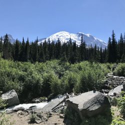
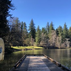
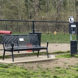
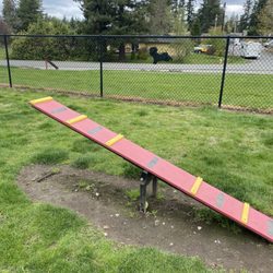
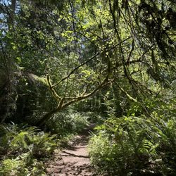
Way, way better than I expected!! Every time I go to Mt Rainier I pass the sign for Mud Mountain Dam, and every time I chuckle at myself that people would want to go there because it sounds super lame. WELL! I had energy left after my Mt Rainier hike, so I decided why not? It's on the way home and the worst thing that happens is I never come back. I was always under the impression that you had to hike in, but after following the road a ways I came to a developed parking lot and what appeared to be a look out point. Nice looking, new playground for the kiddos. Bathrooms are available and a huge props to the people that maintain them!! The buildings were older and a bit run down, but the facilities were *clean*! Even smelled nice, I was really shocked! Lookout point is right off of the parking lot and is ADA accessible. There are several educational signs along the way and in the lookout shelter and some really lovely views! There's also a trail. Pretty short, 1/2 mile? Switchbacks all the way. There's a new chain-link fence for safety and the trail ends at a little lookout point that gets you a lovely view of the dam. Most definitely not worth a special trip, but if it's already on the way it's not a bad idea to stop by and check it out! read more


6 years ago
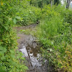
Presently under construction, for the play ground. Once completed though, it looks like it will be fun for little ones. The trail is still open. Beautiful walk. I do not recommend using a bike or a stroller on the trail, lots of cliffs without fencing. A very muddy beautiful walk. read more


More info about Mud Mountain Dam
You might also consider


Mud Mountain Dam - parks - Updated June 2026
Best of Enumclaw
People found Mud Mountain Dam by searching for…
Hiking in Enumclaw, Washington
Playgrounds in Enumclaw, Washington
Things to Do in Enumclaw, Washington
Places to Take Pictures in Enumclaw, Washington
Off Road Trails in Enumclaw, Washington
Hiking Trails in Enumclaw, Washington
Parks for Kids in Enumclaw, Washington
View Points in Enumclaw, Washington
Beautiful Views in Enumclaw, Washington
Hiking With Kids in Enumclaw, Washington
Lookout Points in Enumclaw, Washington
Walking Trails in Enumclaw, Washington
Photo Spots in Enumclaw, Washington
Scenic View in Enumclaw, Washington
Scenic Drive in Enumclaw, Washington
Cliff Diving in Enumclaw, Washington
Picnic Areas in Enumclaw, Washington
Trails in Enumclaw, Washington
Public Bathroom in Enumclaw, Washington
Public Gardens in Enumclaw, Washington
Skyline View in Enumclaw, Washington
Walking at Night in Enumclaw, Washington
Trending Searches in Enumclaw, WA
Baseball Fields near Mud Mountain Dam
Black Owned Nail Salons near Mud Mountain Dam
Boat Rental near Mud Mountain Dam
Cliff Jumping near Mud Mountain Dam
Day Trips near Mud Mountain Dam
Dog Friendly Beaches near Mud Mountain Dam
Fishing Spots near Mud Mountain Dam
Free Picnic Areas near Mud Mountain Dam
Jet Ski Rental near Mud Mountain Dam
Kayak Rental near Mud Mountain Dam
Kids Activities Outdoor near Mud Mountain Dam
Outdoor Basketball Courts near Mud Mountain Dam
Paddle Boat Rentals near Mud Mountain Dam
Pick Your Own Farms near Mud Mountain Dam
Public Beaches near Mud Mountain Dam
River Swimming near Mud Mountain Dam
Soccer Store near Mud Mountain Dam
Splash Pad near Mud Mountain Dam
Strawberry Picking near Mud Mountain Dam
Swimming Holes near Mud Mountain Dam
Swimming Lakes near Mud Mountain Dam
Watch Sunset near Mud Mountain Dam
Browse Articles
Browse Brands
Related Searches in Enumclaw, WA
Best Off Leash Dog Parks in Enumclaw, Washington
Best Parks for Parties and Events in Enumclaw, Washington
Best Water Parks for Kids in Enumclaw, Washington
Check Out Great Playgrounds in Enumclaw, Washington
Discover Baseball Fields Around Enumclaw, Washington
Discover Fun Toddler Parks in Enumclaw, Washington for Your Little One
Discover Lakes & Ponds to Explore in Enumclaw, Washington
Discover Popular Photo Spots in Enumclaw, Washington
Discover Soccer Fields in Enumclaw, Washington Near You
Discover Top Nature Parks to Visit in Enumclaw, Washington
Discover the Best Beaches in Enumclaw, Washington
Discover the Best Kids Park Spots in Enumclaw, Washington
Enjoy the Best Picnic Spots and Ideas in Enumclaw, Washington
Enjoy the Best Walking Trails in Enumclaw, Washington
Explore Beautiful Botanical Gardens in Enumclaw, Washington
Explore Easy Hikes Perfect for All in Enumclaw, Washington
Explore Family-Friendly Zoos and Wildlife in Enumclaw, Washington
Explore Fun Activities to Do in Enumclaw, Washington
Explore Parks With Pull Up Bars in Enumclaw, Washington
Explore Popular Campgrounds Near Enumclaw, Washington
Explore Popular Picnic Areas Around Enumclaw, Washington
Explore Popular RV Parks Around Enumclaw, Washington
Explore Popular Recreation Centers Around Enumclaw, Washington
Explore Scenic Lakes to Visit in Enumclaw, Washington
Explore Top Dog Parks in Enumclaw, Washington Near You
Explore Top Gyms in Enumclaw, Washington Now
Explore Top Water Parks in Enumclaw, Washington Today
Explore the Best Trail Options in Enumclaw, Washington
Find Parks and Recreation Activities in Enumclaw, Washington
Find Top Dog Friendly Parks to Visit in Enumclaw, Washington
Find Top Skate Parks in Enumclaw, Washington for All Skill Levels
Find a Park With BBQ Pits in Enumclaw, Washington
Find the Best Parks BBQ Grills in Enumclaw, Washington
Find the Best Parks for Picnics in Enumclaw, Washington
Find the Best Swimming Pools in Enumclaw, Washington Today
Indoor Playgrounds to Explore in Enumclaw, Washington
Parks With Basketball Courts for Games in Enumclaw, Washington
Picnic Areas With BBQ Pits Available in Enumclaw, Washington
Popular Fishing Spots to Explore in Enumclaw, Washington
Popular Places to Take Pictures in Enumclaw, Washington
Popular Things to See in Enumclaw, Washington
Top Dog Trails for Walking and Hiking in Enumclaw, Washington
Top Hiking Trails to Explore in Enumclaw, Washington
Top Running Trails to Explore in Enumclaw, Washington
Top Swimming Lakes to Enjoy in Enumclaw, Washington
Top-Rated Basketball Courts to Play at in Enumclaw, Washington
Top-Rated Hikes in Enumclaw, Washington to Explore
Visit Popular Museums in Enumclaw, Washington Now
Visit the Best Kids Play Place Options in Enumclaw, Washington