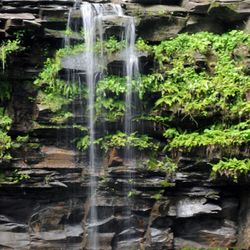
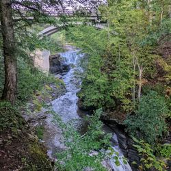
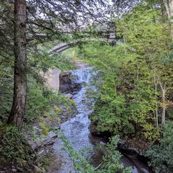
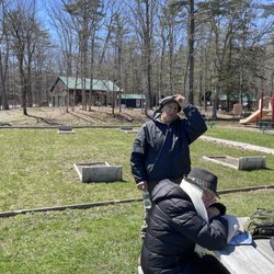
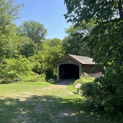
Vroman's Nose Trail Photos


More like Vroman's Nose Trail
Recommended Reviews - Vroman's Nose Trail
Start your review...

I was looking forward to hiking this trail for quite some time. There is a decent size parking lot, although I could see this might fill up on beautiful days. The trail is quick but with decent incline in many spots. It is well worn and there were muddy spots and leaves to watch for. The views are beautiful with large ledges, but you also want to be careful with younger kids. read more


Enjoyed a snowy hike at Vroman's Nose Trail on Friday afternoon. Ended up a bit wetter than expected because of the snow, but worth it for the great views at the top. Quality: A nice hike, which is a bit steep on one end of the loop, but pretty moderate on the other. The views going up are fairly boring, but once you reach the peak there is a lot of cliff to explore. Be cautious in the snow, especially when coming down from the top. Quantity: About a mile and a half hike. Value: Free to park and hike. Ambiance: Vroman's Nose Trial is located in the upstate New York town of Middleburgh. It is a tall hill near a lot of farmland, the peak providing lovely views of the countryside. One half of the loop is very steep and the other is a slow climb. We unknowingly did the slow climb up, which made the steep drop back down quite difficult in the snowy terrain. Not a particularly challenging or long hike, but one impacted by the elements. Crowd: Only one other hiker and for good reason, the snow made it difficult. Service: Well marked and easy to follow even with snow on the path. Parking: Tiny lot near the trailhead. read more


Now I've never been here prior, but recently had found out about this place from a coworker and the AllTrails app (great app too btw). And decided that it would be a great outdoor activity to cure the "stuck inside" blues that have been seemingly plaguing everyone as of late due to current circumstances. Tucked away in the lower region of the Mohawk valley this place is a pure gem! It's set up as a fairly easy loop trial that takes you up a fairly decent incline up the hillside and brings you to these beautiful outlooks in which you can view the valley looking towards the capital district off in the far distance. A decent hike up a moderately rocky terrain; great adventure for both kids and adults! Also dog friendly as well; just don't forget to keep Fido on the leash! Total elevation climb is about 487 feet at the highest point. But it's absolutely worth the view! I'd definitely recommend checking this out and making an afternoon out of it! read more


4 years ago
12 years ago


More info about Vroman's Nose Trail
264 Mill Valley Rd
Middleburgh, NY 12122
Directions
Hours
Outdoor Amenities


Vroman's Nose Trail - hiking - Updated June 2026
Best of Middleburgh
People found Vroman's Nose Trail by searching for…
Things to Do in Middleburgh, New York
Hiking Trails in Middleburgh, New York
Easy Hikes in Middleburgh, New York
Dog Friendly Hiking Trails in Middleburgh, New York
Walking Trails in Middleburgh, New York
Parks in Middleburgh, New York
View Points in Middleburgh, New York
Hikes With Dogs in Middleburgh, New York
Off Leash Dog Hiking Trails in Middleburgh, New York
Fun Things to Do With Kids in Middleburgh, New York
Waterfalls in Middleburgh, New York
Dog Friendly Things to Do in Middleburgh, New York
Running Trails in Middleburgh, New York
Beautiful Views in Middleburgh, New York
Scenic Views in Middleburgh, New York
Trail in Middleburgh, New York
Fishing Spots in Middleburgh, New York
Off Road Trails in Middleburgh, New York
Scenic Overlook in Middleburgh, New York
Views in Middleburgh, New York
Waterfalls and Swimming Holes in Middleburgh, New York
Trending Searches in Middleburgh, NY
Cliff Jumping near Vroman's Nose Trail
Fireworks near Vroman's Nose Trail
Fishing Spots near Vroman's Nose Trail
Lakes near Vroman's Nose Trail
Picnic Areas near Vroman's Nose Trail
Public Pools near Vroman's Nose Trail
River Swimming near Vroman's Nose Trail
Splash Pad near Vroman's Nose Trail
Strawberry Picking near Vroman's Nose Trail
Swimming Holes near Vroman's Nose Trail
Browse Articles
Browse Nearby
Browse Brands
Related Searches in Middleburgh, NY
Best Fishing Locations and Guides in Middleburgh, New York
Best Nature Trails for Hiking in Middleburgh, New York
Best Places for Horseback Riding in Middleburgh, New York
Best Spots for Star Gazing in Middleburgh, New York
Best Waterfalls and Swimming Holes in Middleburgh, New York
Check Out Off Road Trails in Middleburgh, New York
Discover Dog Friendly Trails to Explore in Middleburgh, New York
Discover Popular Bike Trails in Middleburgh, New York
Discover Scenic Mountain Bike Trails Near Middleburgh, New York
Discover Top Boat Tours in Middleburgh, New York for All Ages
Discover Top Nature Parks to Visit in Middleburgh, New York
Discover a Hiking Trail in Middleburgh, New York
Discover the Best Night Hike Trails in Middleburgh, New York
Dog-Friendly Hikes With Dogs in Middleburgh, New York
Effective Stairs Workout Spots in Middleburgh, New York
Enjoy Camping Adventures Around Middleburgh, New York
Enjoy Scenic Night View Experiences in Middleburgh, New York
Enjoy Tent Camping Spots Around Middleburgh, New York
Enjoy the Best Picnic Spots and Ideas in Middleburgh, New York
Enjoy the Best Tubing Experiences in Middleburgh, New York
Enjoy the Best Walking Trails in Middleburgh, New York
Exciting Cliff Jumping Spots in Middleburgh, New York
Experience Stunning Sunset Views in Middleburgh, New York
Explore Beautiful Parks and Green Spaces in Middleburgh, New York
Explore Easy Hikes Perfect for All in Middleburgh, New York
Explore Free Things to Do Around Middleburgh, New York
Explore Popular Campgrounds Near Middleburgh, New York
Explore Popular RV Parks Around Middleburgh, New York
Explore Popular Scenic Overlook Points in Middleburgh, New York
Explore Popular View Points Around Middleburgh, New York
Explore Scenic Lakes to Visit in Middleburgh, New York
Explore the Best Boating Spots in Middleburgh, New York
Explore the Best Swimming Holes Around Middleburgh, New York
Explore the Best Trail Options in Middleburgh, New York
Family Friendly Hiking With Kids in Middleburgh, New York
Find Beautiful Views in Middleburgh, New York
Find Parks and Recreation Activities in Middleburgh, New York
Find the Best Playgrounds to Visit in Middleburgh, New York
Find the Best Scenic View Locations in Middleburgh, New York
Find the Best Swimming Pools in Middleburgh, New York Today
Hiking Trails With Waterfalls in Middleburgh, New York
Must-See Tourist Attractions Around Middleburgh, New York
Off Leash Dog Hiking Trails in Middleburgh, New York
Perfect Spots to Watch Sunset in Middleburgh, New York
Plan a Scenic Drive Route Near Middleburgh, New York
Popular Kids Activities in Middleburgh, New York
Popular Things to Do in Middleburgh, New York
Safe River Swimming Areas in Middleburgh, New York