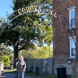
Lisha Kill Natural Area Photos


More like Lisha Kill Natural Area
Recommended Reviews - Lisha Kill Natural Area
Start your review...

Reviews With Photos

Lovely hike, about 2.5 miles with all the side trails. I'd say generally easy but some moderate due to the tree roots and some steep inclines. The side trails were all well marked but the blazes upon entering the main trail were missing and I did overshoot the turnoff. I had to wait and see people coming up the hill so I knew where to go. Gorgeous trees and little streams, and about 1,000 chipmunks. Not crowded at all, saw about 5 people total when I was there.


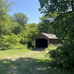
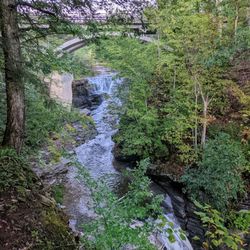
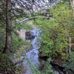
Firstly, I love nature, so any well-intentioned effort to preserve nature gets extra love from me. Lisha Kill Natural Area is one of the best and most beautiful of the many beautiful parks and reserves in the area. And it also more than lives up to the "natural" in its name because there's vast unspoiled natural elements for many to enjoy and appreciate, including streams, unpaved trails, and hills. Speaking of unpaved, this park is largely not wheelchair accessible, and there's no public restroom that I'm aware of, either in the parking lot or within the park. Regardless of which trail you eventually pick, the first about 0.5 mile has steep hills before you cross a bridge over a small creek to climb up to a decision point. The trails are clearly marked with colours on tree trunks, so staying on marked trails has so far been easy. The parking lot has never been full, so parking has never been an issue. Enjoy! read more


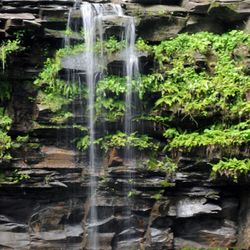
This nature trail is a real treasure. Tucked away off of busy Troy-Schenectady Road, this wooded area offers great hiking. The Lisha Kill is a beautiful creek with easy access. Other reviews said this trail was easy; the exposed roots, steep upgrades and bridges makes me question those reviewers' sanity-I was winded but not exhausted....but I would not think this was easy! I am so happy to have found challenging hiking with a creek. Could not believe all the mushrooms! There a lots of trails to discover so I will be back! read more


Lovely hike, about 2.5 miles with all the side trails. I'd say generally easy but some moderate due to the tree roots and some steep inclines. The side trails were all well marked but the blazes upon entering the main trail were missing and I did overshoot the turnoff. I had to wait and see people coming up the hill so I knew where to go. Gorgeous trees and little streams, and about 1,000 chipmunks. Not crowded at all, saw about 5 people total when I was there. read more


7 years ago
Beautiful spot for hiking with a very "out in the woods" feel for being in the middle of the Capital Region. Just come prepared for some inclines and rough footing in spots. Nice stream flowing through the preserve with a couple good spots for kids to get near the water and play. read more

9 years ago
Great place for a short hike. There is a stream for kids to wade in. Trails are clearly marked. There is a steep incline near the entrance. read more


9 years ago
This place is an average nature trail with small streams. The trails only go so far and then you feel as your hiking in the open woods read more


8 years ago
9 years ago
More info about Lisha Kill Natural Area
Ask the Community - Lisha Kill Natural Area
Review Highlights - Lisha Kill Natural Area


Lisha Kill Natural Area - hiking - Updated May 2026
Best of Niskayuna
People found Lisha Kill Natural Area by searching for…
Places to Take Pictures in Niskayuna, New York
Playgrounds in Niskayuna, New York
Things to Do in Niskayuna, New York
Fun Things to Do With Kids in Niskayuna, New York
Walking Trails in Niskayuna, New York
Hiking Trails in Niskayuna, New York
Off Road Trails in Niskayuna, New York
Beautiful Views in Niskayuna, New York
Running Trails in Niskayuna, New York
Secret Spots in Niskayuna, New York
Swimming Lakes in Niskayuna, New York
Mountain Biking in Niskayuna, New York
State Park in Niskayuna, New York
Scenic Overlook in Niskayuna, New York
Scenic View in Niskayuna, New York
Parks for Kids in Niskayuna, New York
Dog Friendly Hiking Trails in Niskayuna, New York
Picnic Areas in Niskayuna, New York
Secluded Spots in Niskayuna, New York
Trending Searches in Niskayuna, NY
Botanical Gardens near Lisha Kill Natural Area
Bounce House Rentals near Lisha Kill Natural Area
Campgrounds near Lisha Kill Natural Area
Cheap Plants near Lisha Kill Natural Area
Cherry Picking near Lisha Kill Natural Area
Cliff Jumping near Lisha Kill Natural Area
Dog Friendly Things To Do near Lisha Kill Natural Area
Flower Fields near Lisha Kill Natural Area
Flower Shop near Lisha Kill Natural Area
Garage Sales near Lisha Kill Natural Area
Garden Center near Lisha Kill Natural Area
Lakes & Ponds near Lisha Kill Natural Area
Nurseries & Gardening near Lisha Kill Natural Area
Outdoor Activities near Lisha Kill Natural Area
Outdoor Furniture Stores near Lisha Kill Natural Area
Parks near Lisha Kill Natural Area
Party Equipment Rentals near Lisha Kill Natural Area
Pedicure near Lisha Kill Natural Area
Photo Spots near Lisha Kill Natural Area
Picnic Areas near Lisha Kill Natural Area
Places To Take Pictures near Lisha Kill Natural Area
Running Trails near Lisha Kill Natural Area
Rv Rental near Lisha Kill Natural Area
Spray Tanning near Lisha Kill Natural Area
Sunrise View near Lisha Kill Natural Area
Swimming Holes near Lisha Kill Natural Area
Table And Chair Rentals near Lisha Kill Natural Area
Browse Articles
Browse Nearby
BEST of Niskayuna, New York Restaurants near Lisha Kill Natural Area
BEST of Niskayuna, New York Coffee near Lisha Kill Natural Area
BEST of Niskayuna, New York Things to Do near Lisha Kill Natural Area
BEST of Niskayuna, New York Parks near Lisha Kill Natural Area
BEST of Niskayuna, New York Breakfast near Lisha Kill Natural Area
BEST of Niskayuna, New York Horseback Riding near Lisha Kill Natural Area
BEST of Niskayuna, New York Hotels near Lisha Kill Natural Area
Browse Brands
Related Searches in Niskayuna, NY
Best Fishing Locations and Guides in Niskayuna, New York
Best Fun Things to Do in Niskayuna, New York
Best Places for Horseback Riding in Niskayuna, New York
Check Out Off Road Trails in Niskayuna, New York
Discover Popular Photo Spots in Niskayuna, New York
Discover Scenic Mountain Bike Trails Near Niskayuna, New York
Discover Top Boat Tours in Niskayuna, New York for All Ages
Discover a Hiking Trail in Niskayuna, New York
Discover the Best Night Hike Trails in Niskayuna, New York
Dog-Friendly Hikes With Dogs in Niskayuna, New York
Enjoy Exciting Mountain Biking Adventures in Niskayuna, New York
Enjoy the Best Tubing Experiences in Niskayuna, New York
Enjoy the Best Walking Trails in Niskayuna, New York
Exciting Cliff Jumping Spots in Niskayuna, New York
Experience Stunning Sunset Views in Niskayuna, New York
Explore Beautiful Parks and Green Spaces in Niskayuna, New York
Explore Bike Rentals Throughout Niskayuna, New York
Explore Easy Hikes Perfect for All in Niskayuna, New York
Explore Family-Friendly Zoos and Wildlife in Niskayuna, New York
Explore Free Things to Do Around Niskayuna, New York
Explore Popular RV Parks Around Niskayuna, New York
Explore Popular Scenic Overlook Points in Niskayuna, New York
Explore Popular View Points Around Niskayuna, New York
Explore Secret Spots Worth Visiting in Niskayuna, New York
Explore Top Dog Parks in Niskayuna, New York Near You
Explore Top Water Parks in Niskayuna, New York Today
Find Beautiful Views in Niskayuna, New York
Find Popular Ziplining Spots Around Niskayuna, New York
Find Top Dog Swimming Spots in Niskayuna, New York
Find the Best Playgrounds to Visit in Niskayuna, New York
Find the Best Scenic View Locations in Niskayuna, New York
Hiking Trails With Waterfalls in Niskayuna, New York
Locate Tennis Courts Around Niskayuna, New York
Off Leash Dog Hiking Trails in Niskayuna, New York
Plan a Scenic Drive Route Near Niskayuna, New York
Popular Fishing Spots to Explore in Niskayuna, New York
Popular Kids Activities in Niskayuna, New York
Popular Places to Take Pictures in Niskayuna, New York
Popular Things to Do in Niskayuna, New York
Relax at Natural Hot Springs Near Niskayuna, New York
Safe River Swimming Areas in Niskayuna, New York
Safe and Fun Parks for Kids in Niskayuna, New York
Top Paddleboarding Activities in Niskayuna, New York
Top Playgrounds for Kids to Enjoy in Niskayuna, New York
Top Running Trails to Explore in Niskayuna, New York
Top Swimming Lakes to Enjoy in Niskayuna, New York
Top Swimming Spots and Pools in Niskayuna, New York
Top Things to Do With Kids in Niskayuna, New York