Christman Sanctuary Photos


More like Christman Sanctuary
Recommended Reviews - Christman Sanctuary
Start your review...

Reviews With Photos


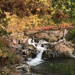
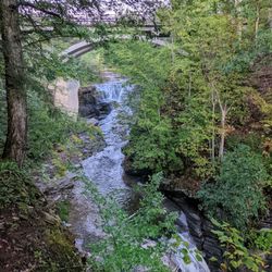
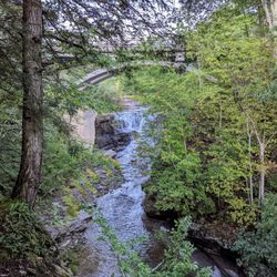
The topography of this place is undulating but not too challenging, even for someone like me, a couch potato. A river runs through it. Along the way, there are some waterfalls of differing levels. Obviously, the volume of water is dependent on recent precipitation. The "mood" of the place depends of that flow. On most occasions, I could hear the rush of water before actually seeing it. It's an added bonus to this place, changing on a daily basis. Like a lot of things upstate, you've got to be informed about a place before you know it exists. If a co-worker hadn't told me about this sanctuary, I doubt I would have found it on my own. There is no fee but the parking lot is small; there's space for about eight vehicles. Check it out. It's a neat place. It'll do some good to get some fresh air. read more


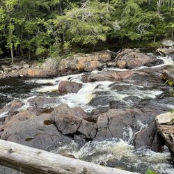
Note to self: September may not be the absolute best time to come here because of the very low flow. Still, there are plenty of things to like about this...once you find it. The falls seem to be commonly known as Bozenkill Falls but the road sign (pictured) says Christman Sanctuary, and the gravel parking lot isn't massive so it may be easy to miss. The first 100+ metres is mostly boardwalks so it's easy enough to navigate. Then comes rocky, uphill trail, but at least markers are readily visible and aplenty. On our first visit I feel like we barely scratched the surface, so will look forward to another visit. Thank you whoever you are, for helping to preserve and maintain this sanctuary! read more


9 months ago


10 years ago
Excellent! 1) The waterfall has lower and upper tier. 2) It is a very short hike to the waterfalls. 3) The lower falls is small and the upper tier is larger. read more


3 years ago
I have been to this trail about 3 times even in the winter. There is 1 waterfall that I know of. During the winter you can see ice spikes running off the waterfall which is pretty cool looking. This is a very small and easy hike which takes about 30 minutes to get to the end where the waterfall is. There are 2 trail ways, green or yellow. The green leads to the bottom of the waterfall which there is only 1 and the yellow leads to the top of the fall. You can also climb up the side of the green trail into the yellow if you are feeling adventurous. Bring bug spray! I've got bitten by mosquitoes numerous times or it could be that are just attracted to me. Parking is very limited. The small lot at the entrance fits about 4-5 cars and the rest would be parking in the side of the road. read more


8 years ago
More info about Christman Sanctuary
3281 Schoharie Turnpike
Delanson, NY 12053
Directions
(518) 690-7878
Call Now
Hours
Outdoor Amenities
Ask the Community - Christman Sanctuary


Christman Sanctuary - hiking - Updated July 2026
Best of Delanson
People found Christman Sanctuary by searching for…
Hiking Trails With Waterfalls in Delanson, New York
Things to Do in Delanson, New York
Attractions in Delanson, New York
Waterfalls and Swimming Holes in Delanson, New York
Places to Take Pictures in Delanson, New York
Walking Trails in Delanson, New York
Waterfalls in Delanson, New York
Running Trails in Delanson, New York
Easy Hikes in Delanson, New York
Things to Do on a Rainy Day in Delanson, New York
Fun Things to Do at Night in Delanson, New York
Off Road Trails in Delanson, New York
Scenic Views in Delanson, New York
Off Leash Dog Hikes in Delanson, New York
Night Hike in Delanson, New York
Fishing Spots in Delanson, New York
Scenic Drive in Delanson, New York
Fun Places to Go in Delanson, New York
Kid Friendly Hiking Trails in Delanson, New York
River Swimming in Delanson, New York
Sunrise View in Delanson, New York
Browse Nearby
BEST of Delanson, New York Restaurants near Christman Sanctuary
BEST of Delanson, New York Things to Do near Christman Sanctuary
BEST of Delanson, New York Beaches near Christman Sanctuary
BEST of Delanson, New York Coffee near Christman Sanctuary
BEST of Delanson, New York Lakes near Christman Sanctuary
BEST of Delanson, New York Breakfast near Christman Sanctuary
Browse Brands
Related Searches in Delanson, NY
Best Fishing Locations and Guides in Delanson, New York
Check Out Off Road Trails in Delanson, New York
Discover the Best Running Track in Delanson, New York
Explore Beautiful Parks and Green Spaces in Delanson, New York
Explore Scenic Lakes to Visit in Delanson, New York
Explore the Best Boating Spots in Delanson, New York
Find Fun Kids Activities Outdoor in Delanson, New York
Find the Best Swimming Pools in Delanson, New York Today
Hiking Trails With Waterfalls in Delanson, New York
Popular Things to Do in Delanson, New York