Central Park Photos


More like Central Park
Recommended Reviews - Central Park
Start your review...


10 months ago


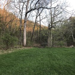
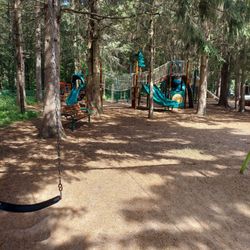
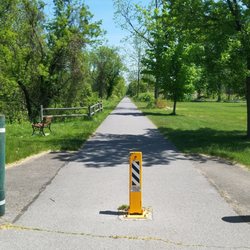
It's pointless to compare this Central Park to THE Central Park. Instead, I give it full marks food all the things it offers residents and visitors - a children's playground with multiple swing sets for all ages across the parking lot from the playground, recently open new public pool, trails, steam, amenities for disc golf, community garden compete with a Period Pantry, dog park, a pond, and more. Each of the several entry points has its own parking lots and parking has never been an issue, and I'm glad we have this space for all to enjoy and help stay active. read more


3 years ago
5 years ago
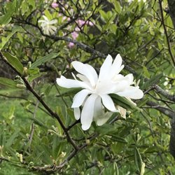
Love this park so much. It's big, has a few playgrounds, a few baseball fields, a disc golf course, a pool, a huge pond, lots of geese and ducks, a dog park, picnic and bbq areas, a music pavilion, a rose garden and I'm sure more. It's so peaceful and family fun. read more


More info about Central Park
Ask the Community - Central Park


Central Park - parks - Updated June 2026
Best of Schenectady
People found Central Park by searching for…
Lakes in Schenectady, New York
Fireworks in Schenectady, New York
Playgrounds in Schenectady, New York
Things to Do in Schenectady, New York
Fun Things to Do With Kids in Schenectady, New York
Picnic Areas in Schenectady, New York
Flower Fields in Schenectady, New York
Baseball Fields in Schenectady, New York
Places to Take Pictures in Schenectady, New York
Disc Golf in Schenectady, New York
Community Gardens in Schenectady, New York
Walking Trails in Schenectady, New York
Lakes & Ponds in Schenectady, New York
Places to Swim in Schenectady, New York
Public Indoor Swimming Pools in Schenectady, New York
Picnic Spots in Schenectady, New York
Scenic Drive in Schenectady, New York
Photo Spots in Schenectady, New York
Fun Things to Do at Night in Schenectady, New York
Hiking Trails With Waterfalls in Schenectady, New York
Playgrounds for Kids in Schenectady, New York
State Park in Schenectady, New York
Trending Searches in Schenectady, NY
Black Owned Nail Salons near Central Park
Cliff Jumping near Central Park
Dog Friendly Beaches near Central Park
Fishing Spots near Central Park
Free Picnic Areas near Central Park
Jet Ski Rental near Central Park
Kayak Rental near Central Park
Outdoor Basketball Courts near Central Park
Public Pools near Central Park
River Swimming near Central Park
Soccer Store near Central Park
Strawberry Picking near Central Park
Swimming Holes near Central Park
Swimming Lakes near Central Park
Browse Articles
Browse Nearby
Browse Brands
Related Searches in Schenectady, NY
Best Nature Trails for Hiking in Schenectady, New York
Best Off Leash Dog Parks in Schenectady, New York
Check Out Great Playgrounds in Schenectady, New York
Discover Baseball Fields Around Schenectady, New York
Discover Free Parking Options in Schenectady, New York
Discover Lakes & Ponds to Explore in Schenectady, New York
Discover Popular Photo Spots in Schenectady, New York
Discover Soccer Fields in Schenectady, New York Near You
Discover Top Nature Parks to Visit in Schenectady, New York
Discover Top Scenic Spots to Visit in Schenectady, New York
Discover the Best Beaches in Schenectady, New York
Enjoy the Best Walking Trails in Schenectady, New York
Explore Beautiful Botanical Gardens in Schenectady, New York
Explore Easy Hikes Perfect for All in Schenectady, New York
Explore Family-Friendly Zoos and Wildlife in Schenectady, New York
Explore Free Picnic Areas Around Schenectady, New York
Explore Fun Activities to Do in Schenectady, New York
Explore Popular Campgrounds Near Schenectady, New York
Explore Popular Picnic Areas Around Schenectady, New York
Explore Popular RV Parks Around Schenectady, New York
Explore Popular Recreation Centers Around Schenectady, New York
Explore Popular Scenic Views Near Schenectady, New York
Explore Scenic Lakes to Visit in Schenectady, New York
Explore Top Dog Parks in Schenectady, New York Near You
Explore Top Gyms in Schenectady, New York Now
Explore Top Water Parks in Schenectady, New York Today
Explore the Best Swimming Holes Around Schenectady, New York
Find Beautiful Views in Schenectady, New York
Find Parks and Recreation Activities in Schenectady, New York
Find Top Dog Friendly Parks to Visit in Schenectady, New York
Find Top Skate Parks in Schenectady, New York for All Skill Levels
Find a Park With BBQ Pits in Schenectady, New York
Find the Best Parks for Picnics in Schenectady, New York
Find the Best Swimming Pools in Schenectady, New York Today
Great Places to Swim in Schenectady, New York
Have Fun at a Splash Pad in Schenectady, New York
Hiking Trails With Waterfalls in Schenectady, New York
Indoor Playgrounds to Explore in Schenectady, New York
Locate Tennis Courts Around Schenectady, New York
Parks With Basketball Courts for Games in Schenectady, New York
Picnic Areas With BBQ Pits Available in Schenectady, New York
Popular Fishing Spots to Explore in Schenectady, New York
Popular Outdoor Activities to Try in Schenectady, New York
Popular Places to Take Pictures in Schenectady, New York
Popular Things to See in Schenectady, New York
Top Dog Trails for Walking and Hiking in Schenectady, New York
Top Hiking Trails to Explore in Schenectady, New York
Top Running Trails to Explore in Schenectady, New York