Hannacroix Preserve Hiking Photos


More like Hannacroix Preserve
Recommended Reviews - Hannacroix Preserve
Start your review...

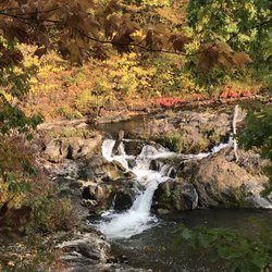
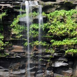
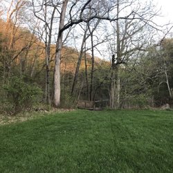
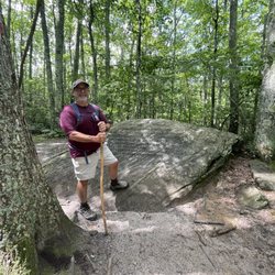
The Hannacroix Ravine, a Nature Conservancy Preserve. It is located in Clarksville, NY, off Cass Road, and we had no problems finding the preserve using the directions on the Nature Conservancy website and Google Maps. There are signs along the road and a small parking lot that holds two cars. I've heard it doesn't really get busy, so parking shouldn't be a concern, but just what I was told. (Note that the Hannacroix Ravine is different from the Hannacroix Preserve in New Baltimore, NY). We started off at the trailhead. There isn't a kiosk at the beginning of the trail, so you might want to save a copy of the trail map to your phone beforehand. The trail meanders through woods, and is mostly flat or only a slight elevation change. My knees have been bothering me lately, so this was a great trail for me. The kids only complained moderately, so overall a success. There isn't a whole lot to do as far as exploring until you come to the creek. We had fun checking out the creek and wandering both up and downstream. We found some fish, newts, crayfish, and more. Being September, the stream was very low. Once we were done exploring the creek, we headed back the way we came. You can also do a loop, which puts you out to the road, and then you have to walk back a bit on the road. I don't think the road is too busy, but we figured the rest of the loop was similar to the first half, so we just went back how we had come in. I would say it was a couple miles from the trailhead to the creek. Overall, a pleasant hike with some nice exploring along the creek. read more


More info about Hannacroix Preserve
373 Cass Hill Rd
Voorheesville, NY 12186
Directions
Hours
Outdoor Amenities


Hannacroix Preserve - hiking - Updated May 2026
Best of Voorheesville
People found Hannacroix Preserve by searching for…
Fishing in Voorheesville, New York
Walking Trails in Voorheesville, New York
Hiking Trails in Voorheesville, New York
Things to Do in Voorheesville, New York
Off Road Trails in Voorheesville, New York
Running Trails in Voorheesville, New York
Waterfalls in Voorheesville, New York
Scenic Views in Voorheesville, New York
Hiking Trails Kid Friendly in Voorheesville, New York
Fishing Spots in Voorheesville, New York
Nature Reserves in Voorheesville, New York
Trail in Voorheesville, New York
Creeks in Voorheesville, New York
Watch Sunset in Voorheesville, New York
Off Leash Dog Hikes in Voorheesville, New York
Waterfalls and Swimming Holes in Voorheesville, New York
Nature Center in Voorheesville, New York
Secluded Spots in Voorheesville, New York
Trending Searches in Voorheesville, NY
Boat Rental near Hannacroix Preserve
Botanical Gardens near Hannacroix Preserve
Bounce House Rentals near Hannacroix Preserve
Campgrounds near Hannacroix Preserve
Cherry Picking near Hannacroix Preserve
Cliff Jumping near Hannacroix Preserve
Dog Friendly Things To Do near Hannacroix Preserve
Flower Fields near Hannacroix Preserve
Flower Shop near Hannacroix Preserve
Garage Sales near Hannacroix Preserve
Lakes & Ponds near Hannacroix Preserve
Nurseries & Gardening near Hannacroix Preserve
Outdoor Activities near Hannacroix Preserve
Outdoor Furniture Stores near Hannacroix Preserve
Parks near Hannacroix Preserve
Party Equipment Rentals near Hannacroix Preserve
Pedicure near Hannacroix Preserve
Pick Your Own Farms near Hannacroix Preserve
Picnic Areas near Hannacroix Preserve
Places To Take Pictures near Hannacroix Preserve
Running Trails near Hannacroix Preserve
Scenic Drive near Hannacroix Preserve
Secret Spots near Hannacroix Preserve
Strawberry Picking near Hannacroix Preserve
Sunrise View near Hannacroix Preserve
Swimming Holes near Hannacroix Preserve
Table And Chair Rentals near Hannacroix Preserve
Browse Articles
Browse Nearby
BEST of Voorheesville, New York Restaurants near Hannacroix Preserve
BEST of Voorheesville, New York Things to Do near Hannacroix Preserve
BEST of Voorheesville, New York Coffee near Hannacroix Preserve
BEST of Voorheesville, New York Lakes near Hannacroix Preserve
BEST of Voorheesville, New York Hotels near Hannacroix Preserve
BEST of Voorheesville, New York Shopping near Hannacroix Preserve
BEST of Voorheesville, New York Dinner near Hannacroix Preserve
Browse Brands
Related Searches in Voorheesville, NY
Best Fishing Locations and Guides in Voorheesville, New York
Best Fun Things to Do in Voorheesville, New York
Best Places for Horseback Riding in Voorheesville, New York
Best Spots for Star Gazing in Voorheesville, New York
Best Waterfalls and Swimming Holes in Voorheesville, New York
Check Out Off Road Trails in Voorheesville, New York
Discover Dog Friendly Trails to Explore in Voorheesville, New York
Discover Scenic Mountain Bike Trails Near Voorheesville, New York
Discover a Hiking Trail in Voorheesville, New York
Discover the Best Night Hike Trails in Voorheesville, New York
Discover the Best Running Track in Voorheesville, New York
Dog-Friendly Hikes With Dogs in Voorheesville, New York
Enjoy Camping Adventures Around Voorheesville, New York
Enjoy Exciting Mountain Biking Adventures in Voorheesville, New York
Enjoy Kayaking Adventures in Voorheesville, New York
Enjoy River Tubing Adventures in Voorheesville, New York
Enjoy Tent Camping Spots Around Voorheesville, New York
Enjoy the Best Family Activities in Voorheesville, New York
Enjoy the Best Picnic Spots and Ideas in Voorheesville, New York
Enjoy the Best Walking Trails in Voorheesville, New York
Exciting Cliff Jumping Spots in Voorheesville, New York
Explore Beautiful Parks and Green Spaces in Voorheesville, New York
Explore Easy Hikes Perfect for All in Voorheesville, New York
Explore Free Things to Do Around Voorheesville, New York
Explore Fun Activities to Do in Voorheesville, New York
Explore Popular Campgrounds Near Voorheesville, New York
Explore Popular Scenic Overlook Points in Voorheesville, New York
Explore Scenic Lakes to Visit in Voorheesville, New York
Explore the Best Beach Spots in Voorheesville, New York
Explore the Best Swimming Holes Around Voorheesville, New York
Family Friendly Hiking With Kids in Voorheesville, New York
Find Popular Ziplining Spots Around Voorheesville, New York
Find the Best Playgrounds to Visit in Voorheesville, New York
Find the Best Scenic View Locations in Voorheesville, New York
Hiking Trails With Waterfalls in Voorheesville, New York
Off Leash Dog Hiking Trails in Voorheesville, New York
Perfect Spots to Watch Sunset in Voorheesville, New York
Plan a Scenic Drive Route Near Voorheesville, New York
Popular Fishing Spots to Explore in Voorheesville, New York
Popular Outdoor Activities to Try in Voorheesville, New York
Popular Picnic Spots to Visit in Voorheesville, New York
Popular Things to Do in Voorheesville, New York
Safe River Swimming Areas in Voorheesville, New York
Safe and Fun Parks for Kids in Voorheesville, New York
Top Playgrounds for Kids to Enjoy in Voorheesville, New York
Top Running Trails to Explore in Voorheesville, New York
Top Swimming Lakes to Enjoy in Voorheesville, New York
Top Swimming Spots and Pools in Voorheesville, New York
People who viewed Hannacroix Preserve also viewed
Hollyhock Hollow Sanctuary
2 reviews
Lisha Kill Natural Area
10 reviews
Hannacroix Creek Preserve
9 reviews
Fisher Trail/Five Rivers
1 review
Vroman's Nose Trail
5 reviews
Plotter Kill Preserve
18 reviews
Schodack Town Park
5 reviews
Max V Shaul State Park
4 reviews
Burden Pond Preserve
2 reviews
Albany County Helderberg-Hudson Rail Trail
3 reviews